Taapaca facts for kids
Quick facts for kids Taapaca, Tara Paka |
|
|---|---|

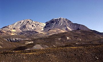
Nevados de Putre, Taapaca volcano (right)
|
|
| Highest point | |
| Elevation | 5,860 m (19,230 ft) |
| Geography | |
| Parent range | Andes |
| Geology | |
| Mountain type | Complex volcano |
| Last eruption | 320 BCE ± 50 years |
| Climbing | |
| First ascent | Inca, pre-Columbian |
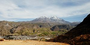
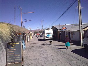
Taapaca is a large volcano in northern Chile. It is located in the Andes mountains. The town of Putre is found right at the base of this volcano.
Like many volcanoes, Taapaca formed when one huge piece of Earth's crust, called the Nazca Plate, slid under another, the South American Plate. This process is called subduction. Taapaca mainly erupted a type of rock called dacite. It formed many lava domes, which are like rounded hills of thick lava.
Volcanic activity at Taapaca started a very long time ago. Sometimes, these lava domes would collapse, causing huge avalanches of rock and ash. Scientists first thought the volcano stopped erupting long ago. But later, they found out it erupted until about 2,300 years ago. The last known eruption was around 320 BCE.
The Chilean Geological Service watches Taapaca. This is because future eruptions could be dangerous for Putre. They could also affect roads and even areas as far away as Bolivia.
Contents
What's in a Name?
The name Taapaca comes from the Aymara language. It means "two-headed eagle" or "winter (prey) bird." In the Quechua language, it means "Andean eagle."
Sometimes, the volcano is also called Nevados de Putre. "Nevados de Putre" can refer to the whole group of volcanoes, while "Taapaca" is used for the highest peak. The name Taapaca might even be linked to an old Aymara god named Viracocha. The name Putre means "sound of falling water" in Aymara.
Where is Taapaca?
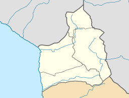
Taapaca is in the Parinacota province of the Arica y Parinacota Region in Chile. Northern Chile doesn't have many recent volcano eruptions. Most of the eruptions happened at volcanoes like Guallatiri, Lascar, and Parinacota.
Taapaca, along with Guallatiri and Parinacota, is part of the Lauca National Park. You can reach Taapaca from the main road that connects Tambo Quemado and Arica.
How Volcanoes Form in the Andes
Volcanoes in the Andes mountains form because the Nazca Plate and the Antarctic Plate are sliding under the South America Plate. This happens in a deep ocean trench called the Peru-Chile Trench. As these plates slide, they create heat and pressure. This causes melted rock, called magma, to rise and form volcanoes.
Not all places where plates slide create volcanoes. In some areas, the plate slides more flatly, and no volcanoes form. Volcanoes have been active in the Andes for about 185 million years. Today, the Andes has about 178 volcanoes that have been active in the last 10,000 years. About 60 of these have erupted in recorded history.
Taapaca's Neighborhood
Taapaca is part of the Central Volcanic Zone of the Andes. This is one of four main volcanic belts in the Andes. This zone has about 44 active volcanoes. Many older volcanoes here are still well-preserved because the climate is very dry.
The Central Volcanic Zone has some of the world's highest volcanoes. They can reach heights of 5,000–7,000 metres (16,000–23,000 ft). The biggest eruption in this zone happened at Huaynaputina in 1600. Lascar is the most active volcano in the area. Most volcanoes here are far from towns, so their eruptions are not well recorded.
Taapaca is on the edge of a high plateau called the Altiplano. The rocks beneath Taapaca are older volcanic and sedimentary layers. Other volcanoes like Condoriri, Pomerape, Larancagua, and Parinacota are to the east of Taapaca.
What Taapaca Looks Like
Taapaca is 5,860 metres (19,230 ft) tall. It is a volcanic complex, which means it's made of many overlapping volcanoes and lava domes. It stretches from west to east. Larancagua volcano is just to its east.
Taapaca mostly has many overlapping lava domes. These domes can be round or oval shaped. Lava flows are not very common here. The volcano has also created large piles of rock and ash, especially on its western, southwestern, and eastern sides. These piles have filled up valleys. There is also an andesitic stratovolcano within the complex. The whole volcano is about 35 cubic kilometres (8.4 cu mi) in size. Its volcanic material covers an area of 250 square kilometres (97 sq mi).
The main peak of Taapaca is a younger lava dome. Another older dome is just to its west. Taapaca is usually covered in snow. It does not have large glaciers, but it does have block glaciers, which are like frozen rivers of rock.
The Lluta River starts on Taapaca mountain. It flows through a valley west of the volcano. Other parts of the mountain drain into the Rio Lauca to the east. Putre, the main town in this part of Chile, is southwest of Taapaca.
What Taapaca is Made Of
Taapaca is mostly made of a type of rock called dacite. Early in its history, it also erupted andesite. One small amount of rhyolite has also been found. The rocks from Taapaca have been quite similar over time.
You can see minerals like amphibole, biotite, hornblende, magnetite, plagioclase, quartz, and sanidine in the rocks. The dacite rocks often have darker pieces inside them. These pieces are called mafic inclusions.
These inclusions show that different types of melted rock (magma) mix inside Taapaca. When new, hot magma pushes into the existing magma chambers, it can trigger new eruptions. The main magma chamber seems to be very deep, about 15–20 kilometres (9.3–12.4 mi) underground. The magma also interacts with the Earth's crust as it rises. This changes the magma's makeup.
Climate and Nature
Taapaca has a tropical alpine climate. This means temperatures can change a lot between day and night. It can even frost at night any time of year. Temperatures usually range between 0–20 °C (32–68 °F).
Unlike most of Chile, it rains mostly in the summer here. Snow can fall in June and July. But overall, the climate is very dry, so there isn't a lot of plant life.
On the south side of Taapaca, you'll find Puna shrubs and steppe. Further west, it becomes shrubland. You can also see cushion plants like Azorella compacta and Polylepis trees. There are also wetlands called bofedales. In the past, there were more forests in this area.
Animals living here include birds, flamingos, guanacos, huemuls, rheas, vicuñas, and viscachas. You might also spot pumas and rodents. Much of this area, including Taapaca, is protected as part of the Lauca National Park.
Eruptions of Taapaca
Scientists first thought Taapaca had three main periods of activity over the last 1.5 million years. Later, a fourth period was found. Some rocks are even older than 1.5 million years.
Eruptions at Taapaca often involved forming lava domes. These domes would then collapse, causing explosive avalanches of blocks and ash. This has been seen at other volcanoes like Soufriere Hills and Unzen. Taapaca has only had one large explosive eruption, and its ash deposits are not widespread. Over time, the eruptions at Taapaca have moved about 4–5 kilometres (2.5–3.1 mi) to the south-southwest.
The volcano has also experienced large landslides. These happen when parts of the volcano collapse. This can be due to the volcano becoming unstable or weakened by hot water activity.
Stages of Eruption
The oldest eruptions happened a very long time ago. They formed andesite lava flows. This early volcano was likely a wide stratovolcano.
Later, between 1.5 and 0.5 million years ago, dacitic lava flows and lava domes built up most of the northern and eastern sides of the volcano. Large avalanches of blocks and ash also covered areas up to 13 kilometres (8.1 mi) long. These often had mudflows (called lahars) with them. During this time, Taapaca was probably a large stratovolcano with steep lava domes.
The third stage of activity was similar. It built up the central, eastern, and southwestern parts of the volcano. More lava domes formed, some looking like "pancakes." Both the second and third stages were affected by glacial erosion. This, along with later collapses, removed much of the volcano's original shape.
The fourth stage includes activity from the last 450,000 years up to today. This stage started with a large debris avalanche. This avalanche happened when an older part of the volcano collapsed. Later, more lava flows and domes formed on the southern and western slopes. Another large debris avalanche happened between 25,000 and 9,000 years ago. The town of Putre is built on these old avalanche deposits.
Even though Taapaca was once thought to be an extinct volcano, later research found eruptions during the last 10,000 years (the Holocene period). These eruptions created new lava domes and layers of ash and rock on the southern and southwestern sides. At least three explosive eruptions happened within the last 8,000 years. The last eruption was about 2,300 years ago, around 320 BCE.
In the early 1900s, people reported seeing steam (called fumaroles) coming from Taapaca. But there have been no recorded eruptions in modern history. Today, the only activity is from hot springs.
Dangers and Safety
Most volcanoes in northern Chile are far from towns, so they don't pose a big risk to people. But Taapaca is different. Putre, the main town nearby, is built on old volcanic deposits from Taapaca. This means it could be in danger from future eruptions.
A major highway that connects Bolivia to the Pacific Ocean also runs near the volcano. Other towns like Socoroma and Zapahuira, and even parts of Bolivia, could be affected. The danger is greater because recent eruptions have mostly affected the southwestern side, where Putre is located. On average, Taapaca erupts about every 450 years.
Future eruptions could cause more parts of the volcano to collapse. If new lava domes form, they could create dangerous avalanches of rock and ash. If eruptions happen between April and November, when the volcano is covered in snow, they could cause large mudflows (lahars). Heavy rain during the wet season (December to March) can also cause lahars. These mudflows often damage roads.
The Chilean geological service, SERNAGEOMIN, watches Taapaca. They have a volcano hazard level for it. They also publish a map that shows areas at risk from falling rocks, ash clouds, and ashfall.
History and Mining
People in the Andes still practice Mountain worship. In 2002, climbers found a small figurine made of a seashell on Taapaca's summit. These figurines were very important to the Inkan people for rain rituals. The figurine was found inside a circle of rocks. More Inkan ruins were found nearby. The figurine was likely placed there to ask for water, as the Inkans believed mountains controlled weather and helped plants and animals grow. Taapaca was an Inkan mountain sanctuary, and people still say the mountain protects the community of Putre.
Taapaca also has deposits of sulfur near its top. Starting in the 1930s, a company called Empresa Azufrera Taapaca mined sulfur on the volcano. Taapaca's crater became a mining camp. This mining activity provided many jobs for people in Putre.
See also
 In Spanish: Volcán Taapacá para niños
- List of volcanoes in Chile
- Tacora
 | Roy Wilkins |
 | John Lewis |
 | Linda Carol Brown |


