
Arlington County, Virginia facts for kids
Quick facts for kids
Arlington County
|
|||||
|---|---|---|---|---|---|
      |
|||||
|
|||||

Location within the U.S. state of Virginia
|
|||||
 Virginia's location within the U.S. |
|||||
| Country | |||||
| State | |||||
| Founded | February 27, 1801 | ||||
| Named for | Arlington House | ||||
| Area | |||||
| • Total | 26 sq mi (70 km2) | ||||
| • Land | 26 sq mi (70 km2) | ||||
| • Water | 0.2 sq mi (0.5 km2) 0.4% | ||||
| Population
(2020)
|
|||||
| • Total | 238,643 | ||||
| • Density | 9,180/sq mi (3,540/km2) | ||||
| Time zone | UTC−5 (Eastern) | ||||
| • Summer (DST) | UTC−4 (EDT) | ||||
| Congressional district | 8th | ||||


Arlington County, often called Arlington, is a county in the state of Virginia. It's located in Northern Virginia, right across the Potomac River from Washington, D.C., our nation's capital.
Arlington County is the same area as the U.S. Census Bureau's "census-designated place" of Arlington. In 2020, it had a population of 238,643 people. This makes it the eighth-most populated county in the Washington metropolitan area. If Arlington County were a city, it would be the third-largest in Virginia. It's also the smallest self-governing county in the United States, with a land area of only 26 square miles (67 km2).
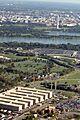
Arlington County is home to some very important places. These include the Pentagon, which is the headquarters of the U.S. Department of Defense. Other key spots are Reagan National Airport and Arlington National Cemetery. Many colleges and universities also have campuses here, like Marymount University and parts of George Mason University. Big companies like Amazon (with one of its main headquarters), Boeing, and Raytheon Technologies also have offices in Arlington.
Contents
History of Arlington County
Early Days and Naming
Present-day Arlington County was once part of Fairfax County in the Colony of Virginia. Land was given to important Englishmen during this time. One of these people was Thomas Fairfax, who gave his name to Fairfax County.
Arlington County got its name from Arlington House. This famous house was part of a large plantation along the Potomac River. George Washington Parke Custis, who was the grandson of First Lady Martha Washington, bought this land in 1802. Later, the estate went to Mary Anna Custis Lee, who was the wife of Robert E. Lee. He was a general during the American Civil War. The U.S. government later took the property, and it became Arlington National Cemetery.
Becoming Part of Washington, D.C.
In 1790, the U.S. Congress decided to move the nation's capital from Philadelphia to a new spot on the Potomac River. President George Washington chose the location. This new area included what is now Arlington County and part of Alexandria.
The new federal district was a square, 10 miles (16 km) on each side. In 1791 and 1792, Andrew Ellicott and his team placed special stones to mark the district's borders. Many of these stones are still standing today.
In 1801, Congress officially organized the District of Columbia. The land west of the Potomac River, which included most of present-day Arlington County, became "Alexandria County." People living in this area were no longer considered residents of Virginia. This meant they lost their right to vote for representatives in Congress.
Returning to Virginia
Over time, people in Alexandria County felt that being part of the federal district wasn't helping them. They hoped for economic growth, but it didn't happen as expected. Congress also didn't allow federal offices to be built in Alexandria.
There were also disagreements about slavery. Some people in Virginia wanted Alexandria to return to the state. They believed it would help their cause. In 1846, Congress voted to return all the land south of the Potomac River back to Virginia. President James K. Polk signed this law. People in Alexandria voted for this change. After some debate, Virginia officially accepted Alexandria County back in 1847.
In 1852, the City of Alexandria became a separate city from Alexandria County.
Arlington During the Civil War

When the American Civil War began in 1861, Virginia decided to leave the Union. While the City of Alexandria mostly supported leaving, many people in the rural parts of Alexandria County remained loyal to the Union.
During the war, the U.S. government took over the Abingdon estate, which is now near Ronald Reagan Washington National Airport. This happened because the owner, who was fighting for the Confederacy, couldn't pay his property taxes in person.
The government also took over Arlington House, the home of General Robert E. Lee's family. Lee's wife, Mary Anna Custis Lee, owned the property. She tried to pay the taxes through an agent, but Union officials refused. The property was then turned into a military cemetery.
After the war, Lee's eldest son, George Washington Custis Lee, went to court to get the property back. In 1882, the U.S. Supreme Court agreed that the government had taken the land illegally. The property was returned to Custis Lee. However, in 1883, Congress bought the property from him for $150,000. It then officially became a military cemetery, which is now Arlington National Cemetery. Today, Arlington House is a memorial to Robert E. Lee.
Even though there were some small battles, the area that is now Arlington never fell under Confederate control.
Renaming and Growth

In 1870, the City of Alexandria officially separated from Alexandria County. This caused confusion because both had the same name. So, in 1920, the Virginia legislature renamed Alexandria County to Arlington County. The new name honored Arlington House.
The early 1900s saw new electric trolley lines built, which helped the county grow. In the 1930s, places like Buckingham and Colonial Village apartment communities opened. World War II brought a big increase in people moving to Arlington.
In 1959, Arlington Public Schools began to end racial segregation at Stratford Junior High School. This happened after the U.S. Supreme Court ruled in 1954 that "separate but equal" schools were not fair. Arlington was one of the first places in Virginia to integrate its schools.
During the 1960s, Arlington faced challenges with its growing population. The county decided to focus on public transportation. They worked to bring the Washington Metro rail system to Arlington. This led to the creation of the Orange and Blue Metro lines in 1977. These lines helped develop areas like Rosslyn, Ballston, and Crystal City. Property values near Metro stations increased a lot. This growth changed the county, bringing in many new residents and businesses.
Arlington in the 21st Century

On September 11, 2001, terrorists crashed American Airlines Flight 77 into the Pentagon. This terrible event killed many people in the building and on the plane. It was a very sad day in world history.
In recent years, Arlington has continued to grow. In 2018, Amazon announced it would build one of its main headquarters in the Crystal City neighborhood. This area was then renamed National Landing.
In 2023, Arlington County made a change to its zoning laws. This change would allow more types of housing, like six-unit buildings, in areas that used to only allow single-family homes. This was meant to help create more affordable housing. However, a judge later overturned this change.
Geography of Arlington

Arlington County is in Northern Virginia. It borders Fairfax County and Falls Church to the west. To the southeast is the city of Alexandria. To the northeast, across the Potomac River, is Washington, D.C.. The Potomac River forms Arlington's northern border.
Arlington County is the smallest self-governing county in the United States. About 17.6% of the county is federal property, meaning it belongs to the U.S. government. The county's main government offices are in the Courthouse neighborhood.
Arlington has a plan to focus new buildings and growth near public transportation, like Metro stations. This helps create "urban village" communities where people can walk or use public transit easily. Some of these communities include:
In 2002, Arlington won an award for its "Smart Growth" efforts. This means the county plans its growth in a way that is good for the environment and the community. Many of Arlington's neighborhoods are listed on the National Register of Historic Places.
Arlington is often divided into North Arlington and South Arlington. These areas have some differences in how they developed and the types of services they receive.
Arlington is known for its parks. In 2018, it ranked fourth in the nation for park access and quality.
Climate in Arlington
Arlington County has hot, humid summers and mild to moderately cold winters. Spring and fall are usually pleasant. The county gets about 41.82 inches (106 cm) of rain each year. Snowfall averages about 13.7 inches (35 cm) per year, mostly in January and February.
People of Arlington
| Historical population | |||
|---|---|---|---|
| Census | Pop. | %± | |
| 1800 | 5,949 | — | |
| 1810 | 8,552 | 43.8% | |
| 1820 | 9,703 | 13.5% | |
| 1830 | 9,573 | −1.3% | |
| 1840 | 9,967 | 4.1% | |
| 1850 | 10,008 | 0.4% | |
| 1860 | 12,652 | 26.4% | |
| 1870 | 16,755 | 32.4% | |
| 1880 | 17,546 | 4.7% | |
| 1890 | 18,597 | 6.0% | |
| 1900 | 6,430 | −65.4% | |
| 1910 | 10,231 | 59.1% | |
| 1920 | 16,040 | 56.8% | |
| 1930 | 26,615 | 65.9% | |
| 1940 | 57,040 | 114.3% | |
| 1950 | 135,449 | 137.5% | |
| 1960 | 163,401 | 20.6% | |
| 1970 | 174,284 | 6.7% | |
| 1980 | 152,599 | −12.4% | |
| 1990 | 170,936 | 12.0% | |
| 2000 | 189,453 | 10.8% | |
| 2010 | 207,627 | 9.6% | |
| 2020 | 238,643 | 14.9% | |
| U.S. Decennial Census 1790-1960 1900-1990 1990-2000 2010-2020 2010 2020 |
|||
Population Facts
In 2020, Arlington County had 238,643 people. The population density was high, with about 8,853 people per square mile.
Arlington is a very diverse place. In 2020, about 58.5% of residents were White (not Hispanic), 8.5% were Black, 11.4% were Asian, and 15.7% were Hispanic or Latino (of any race). Many residents were born outside the United States.
Arlington has a high percentage of people living alone. In 2009, about 70.9% of people in Arlington were single.
Arlington is known for having a highly educated population. In 2006, CNN Money ranked Arlington as the most educated city, with many residents holding advanced degrees. It also ranks among the counties with the highest average household income in the U.S.
For six years in a row, the American College of Sports Medicine has named Arlington the "Fittest City in America."
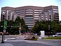
Economy of Arlington
Arlington usually has one of the lowest unemployment rates in Virginia. In July 2023, the unemployment rate was very low at 1.9%. A large part of the jobs in Arlington are with government agencies or companies that work for the government.
In 2008, there were about 205,300 jobs in the county. About 28.7% of these jobs were with federal, state, or local governments. Many other jobs are in technology, professional services, and hospitality.
In March 2024, the average cost of a home in Arlington was $881,925. Many homes are worth over $1 million. Most people who work in Arlington commute from other areas.
Companies and Organizations in Arlington
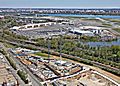
_at_1800_North_Nash_Street_November_2013.jpg)
Many important companies have their headquarters or major offices in Arlington. These include Amazon (with its second headquarters), Boeing, RTX Corporation (formerly Raytheon), and Nestlé USA. Many consulting firms and defense industry companies are also located here.
Several well-known organizations are based in Arlington, such as The Nature Conservancy, the Public Broadcasting Service (PBS), and United Service Organizations (USO).
Some media companies like Politico and Axios also have their main offices in Arlington.
Top Employers
Here are some of the largest employers in Arlington County:
| # | Employer |
|---|---|
| 1 | Federal government |
| 2 | Local government & schools |
| 3 | Amazon |
| 4 | Deloitte |
| 5 | Accenture |
| 6 | Virginia Hospital Center |
| 7 | Lidl |
| 8 | Bloomberg BNA |
| 9 | Nestlé |
| 10 | Booz Allen Hamilton |
Famous Places in Arlington


Arlington National Cemetery
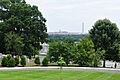
Arlington National Cemetery is a military cemetery. It was created during the American Civil War on the land of Arlington House, which was once the home of Confederate General Robert E. Lee. The cemetery is located across the Potomac River from Washington, D.C., near the Pentagon. It is the second-largest national cemetery in the U.S., with about 400,000 graves across 639 acres.
Arlington House was built by George Washington Parke Custis, the grandson of George Washington. It was home to the Lee family for 30 years. After the Civil War began, the Lee family left. The U.S. government took the land and made it a military cemetery in 1864. Later, the government bought the land from the Lee family.
Veterans from all of America's wars are buried here, from the American Revolution to more recent conflicts. The Tomb of the Unknowns is a special memorial for unknown soldiers. President John F. Kennedy is buried here with an eternal flame marking his grave. His brothers, Robert F. Kennedy and Edward M. Kennedy, are also buried nearby. William Howard Taft is the only other U.S. President buried at Arlington.
Other important sites near the cemetery include the U.S. Marine Corps War Memorial (Iwo Jima Memorial) and the U.S. Air Force Memorial.
The Pentagon


The Pentagon is the headquarters of the United States Department of Defense. It was finished in 1943 and is the world's second-largest office building. Even though it's in Arlington County, mail sent to the Pentagon uses "Washington, D.C." as the city name.
The building is shaped like a pentagon (a five-sided shape). It has five floors and five ring-shaped hallways on each floor. About 24,000 military and civilian employees work there. It has 17.5 miles (28 km) of hallways, but you can walk between any two points in about seven minutes!
The Pentagon was built during World War II using a lot of sand and gravel from the nearby Potomac River. Very little steel was used because it was needed for the war effort.
The open area in the middle of the Pentagon is the world's largest "no-salute, no-cover" area for U.S. service members. The Pentagon Memorial, which remembers the victims of the September 11 attacks, is located outside the building and is a popular place to visit.
Transportation in Arlington
_from_the_overpass_for_U.S._Route_1_southbound_(Richmond_Highway)_in_Arlington_County,_Virginia.jpg)
Roads and Paths
Arlington has two major interstate highways: I-66 in the north and I-395 in the east. Both have special lanes for cars with multiple passengers. The George Washington Memorial Parkway also runs through the county. Arlington County manages 376 miles (605 km) of roads.
Street names in Arlington usually follow a pattern. North-south streets are often in alphabetical order. Many east-west streets are numbered. U.S. Route 50 divides Arlington County. Streets north of Route 50 are usually "North," and streets south are "South."
Arlington has over 100 miles (160 km) of bike paths. These paths follow rivers, old railroad lines, or major highways. Popular trails include the Four Mile Run Trail, the Custis Trail, and the Washington & Old Dominion Railroad Trail.
Public Transportation
_-_02.jpg)
Arlington is a major hub for public transportation in Virginia. Most transit trips in Virginia start or end in Arlington, often at Washington Metro rail stations.
Arlington has stations on the Blue, Orange, Silver, and Yellow lines of the Washington Metro rail system. The county is also served by the regional Metrobus service. This includes Metroway, a fast bus system that works like a train.
Arlington also has its own bus system called Arlington Transit (ART). This system adds to the Metrobus service with routes within the county. The Virginia Railway Express (VRE) commuter train also has a station in Crystal City.
Other Transportation


Capital Bikeshare, a bike-sharing system, started in Arlington in 2010. You can rent bikes from many locations, especially near Metro stations.
Ronald Reagan Washington National Airport is located in Arlington County. It provides flights for the Washington, D.C., area. In 2009, readers of Condé Nast Traveler voted it the country's best airport.
Arlington is also known for its "green" transportation efforts. In 2007, it became the first place in the U.S. to have an all-hybrid taxi fleet. Arlington has a higher than average number of households that do not own a car, showing its focus on public transit and walking.
Education in Arlington
Schools for Kids

Arlington Public Schools runs the public school system for students from kindergarten to 12th grade. There are 22 elementary schools, six middle schools, and three high schools. These high schools are Wakefield High School, Washington-Liberty High School, and Yorktown High School. Arlington also has alternative public schools like H-B Woodlawn and Arlington Tech.
Arlington County spends about half of its local money on education. The school board has five members who are elected to four-year terms.
Colleges and Universities
Marymount University is the only university with its main campus in Arlington County. It was founded in 1950.
George Mason University has a campus in the Virginia Square area. This campus is home to its law school and schools for policy and government.
In 2011, Virginia Tech opened a research center in Ballston. This center helps graduate students with computer research and engineering. The University of Virginia also has some business programs in Rosslyn. Other schools like DeVry University and Strayer University also have campuses in Arlington.
Sister Cities
The Arlington Sister City Association (ASCA) helps Arlington connect with cities around the world. This group works to improve education, business, and culture through different activities. Since 1993, ASCA has supported Arlington County's five sister cities:
 Aachen, Germany
 Coyoacán (Mexico City), Mexico
 Ivano-Frankivsk, Ukraine
 Reims, France
 San Miguel, El Salvador
Notable People from Arlington


Many famous people have lived in Arlington County, including:
- Sandra Bullock, actress
- Katie Couric, television journalist
- Roberta Flack, musician
- John Glenn, former U.S. Senator and astronaut
- Al Gore, former U.S. Vice President
- Grace Hopper, U.S. Navy rear admiral
- Robert E. Lee, Civil War general
- Shirley MacLaine, actress
- Jim Morrison, singer for The Doors
- George S. Patton, U.S. Army general during World War II
Images for kids
-
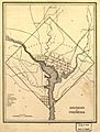
An 1835 map of the District of Columbia, before Alexandria County returned to Virginia.
-
Arlington National Cemetery, located on land taken from Confederate General Robert E. Lee during the American Civil War.
-
The former Arlington County seal used from 1983 to 2007.
-
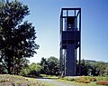
The Netherlands Carillon.
-
The former Navy Annex and Air Force Memorial.
-
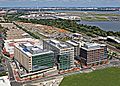
Arlington County National Gateway.
-
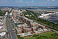
Arlington County IDA Potomac Yard.
-
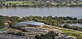
Arlington County Aquatic and Fitness Center.
-
Arlington County Virginia Tech Innovative Campus Project.
-
Park Four, a building in Crystal City.
-
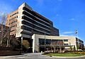
Virginia Hospital Center in Arlington County.
-
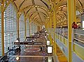
Ronald Reagan Washington National Airport in Crystal City.
-

Hybrid taxis in Pentagon City.
-

USS Arlington (LPD-24), a U.S. Navy ship named for Arlington.


.svg)


_underway_in_August_2014.JPG)
See also
 In Spanish: Condado de Arlington para niños
