
Vermilion County, Illinois facts for kids
Quick facts for kids
Vermilion County, Illinois
|
||
|---|---|---|
 Vermilion County Courthouse
|
||
|
||

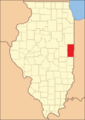
Location within Illinois
|
||

Illinois' location within the United States
|
||
| Country | United States | |
| State | Illinois | |
| Region | Central Illinois | |
| Metro area | Danville Micropolitan | |
| Incorporated | January 18, 1826 | |
| Named for | Vermilion River | |
| County seat and largest city | Danville | |
| Area | ||
| • Total | 901.28 sq mi (2,334.3 km2) | |
| • Land | 898.37 sq mi (2,326.8 km2) | |
| • Water | 2.91 sq mi (7.5 km2) | |
| Area rank | 7th largest county in Illinois | |
| Population | ||
| • Total | 74,188 | |
| • Density | 82.3140/sq mi (31.7816/km2) | |
| Time zone | UTC−6 (Central) | |
| • Summer (DST) | UTC−5 (Central) | |
| ZIP Code prefixes |
60932, 60942, 60960, 60963, 61810, 61811, 61812, 61814, 61817, 61831, 61832, 61833, 61834, 61841, 61844, 61846, 61848, 61849, 61850, 61857, 61858, 61859, 61862, 61865, 61870, 61876, 61883
|
|
| Area codes | 217/447 | |
| Congressional district | 2nd, 15th | |
| Website | www.vercounty.org | |

Vermilion County is a county located in the eastern part of Illinois, a state in the United States. It sits right between the Indiana border and Champaign County. The county was officially created in 1826. It was the 45th county out of Illinois's 102 counties.
In 2020, about 74,188 people lived here. Vermilion County has 21 towns and villages. The biggest city and the main government center is Danville. Vermilion County is part of the Danville Micropolitan Statistical Area. It's also part of the larger Champaign–Urbana–Danville Combined Statistical Area.
Contents
History of Vermilion County
Vermilion County gets its name from the Vermilion River. This river flows through the county and into the Wabash River in Indiana. The river was called "Vermilion" because of the reddish color of the earth along its banks.
Early Control and Formation
From 1682 to 1763, the area that is now Vermilion County was part of New France, controlled by France. After the French and Indian War, Great Britain took control for 15 years.
After the American Revolutionary War, the land became part of the American colonies. It was first part of Virginia, then the Indiana Territory, and later the Illinois Territory. Finally, it became part of the state of Illinois. Vermilion County was officially created on January 18, 1826. It was formed from a part of Edgar County. Over time, other counties like Champaign, Iroquois, and Ford were formed from land that was once connected to Vermilion County.
Salt Springs and First Settlements
Early explorers were very interested in the county's natural salt springs. These springs were mentioned as early as 1801. Making salt from the spring water was profitable from 1822 to 1829. After that, salt became cheaper to buy, so it was no longer worth making it there.
The first settlement in the area was made in 1819 near these salt springs. Later, in 1820, James Butler started a settlement near what is now Catlin. This area became known as "Butler's Point." In the southern part of the county, Henry Johnson built a cabin. This area was called "Johnson's Point." Many early settlers in Vermilion County came from the southern United States. They often moved because they were against slavery.
Some of the first settlers were Quakers. They founded a community called Vermilion Grove in the southern part of the county. This was one of the county's first settlements. It was also the site of the county's second public school.
Abraham Lincoln's Connection
Vermilion County has strong ties to Abraham Lincoln. He practiced law in Danville from 1841 to 1859 with his partner, Ward Hill Lamon. Lamon later became Lincoln's bodyguard. Lincoln even gave a speech in Danville in 1858 during his campaign for the U.S. Senate. He spoke from the balcony of Dr. William Fithian's home. The Fithian home is now a museum called the Vermilion County Museum. Visitors can see items related to Lincoln, including a bed where he slept.
County's Changing Borders
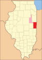
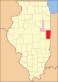
The county's shape and size changed several times over the years. The pictures below show how Vermilion County looked at different times.
-
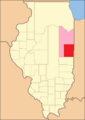
Vermilion County from 1826 to 1831, including a large area temporarily attached to it.
-
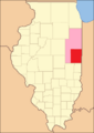
Vermilion County between 1831 and 1833.
-

The county between 1833 and 1836, after Champaign and Iroquois Counties were created.
-
Vermilion County between 1836 and 1837.
-
Vermilion County between 1837 and 1853.
-

Vermilion County after 1853, when the attached territory was made smaller.
-
In 1859, the extra territory became Ford County, making Vermilion County its current size.


Geography of Vermilion County

Vermilion County is located on the eastern edge of Illinois. Its northern border is about 95 miles (153 km) south of Chicago. Vermilion County in Illinois and Vermillion County in Indiana are two of the few counties in the U.S. with the same name that border each other across state lines.
The county covers about 901.28 square miles (2,334.3 km²). Most of this area, about 898.37 square miles (2,326.8 km²), is land. Only a small part, 2.91 square miles (7.5 km²), is water. The land in Vermilion County is mostly made of rich, fertile soil called silt loam. Lake Vermilion is the county's largest body of water. It is a man-made lake of 1,000 acres (400 ha) located northwest of Danville. This lake provides drinking water for Danville and is also a popular spot for recreation.
Neighboring Counties
Vermilion County shares borders with these counties:
- Iroquois County – north
- Benton County, Indiana – northeast
- Warren County, Indiana – east
- Vermillion County, Indiana – southeast
- Edgar County – south
- Douglas County - southwest
- Champaign County – west
- Ford County – northwest
Cities in Vermilion County
- Danville (This is the county seat, where the main government offices are located)
- Hoopeston
- Georgetown
Villages in Vermilion County
Unincorporated Communities
These are smaller communities that are not officially organized as cities or villages:
Former Settlements
Some towns that once existed in Vermilion County are no longer there. For example, when railroads were built, some towns were left behind because the new train lines didn't pass through them. Also, when Lake Vermilion was created, the town of Denmark was flooded and now lies at the bottom of the lake.
- Archie
- Blue Grass City
- Butler's Point
- Conkeytown
- Denmark
- Ellis
- Franklin
- Geneva
- Gilbert
- Humrick
- Johnsonville
- Munroe
- Myersville
- Pellsville
- Prospect City
- Reilly
- Shepherd's Town
- Watkins Grove (or Watkins Glen)
- Weaver City
Townships
Vermilion County is divided into smaller government areas called townships. This system was started on November 5, 1850, with eight original townships:
- Carroll
- Danville
- Elwood
- Georgetown
- Middlefork
- Newell (first called Richland)
- Pilot
- Ross
Over the next few decades, eleven more townships were created:
- Blount
- Butler
- Catlin
- Grant
- Jamaica
- Love
- McKendree
- Oakwood
- Sidell
- South Ross
- Vance
Parks and Natural Areas
The Vermilion County Conservation District manages four parks where people can enjoy nature:
- Forest Glen Preserve
- Heron County Park
- Kennekuk Cove County Park
- Lake Vermilion County Park
The Illinois Department of Natural Resources also looks after three important natural areas in the county:
- Kickapoo State Recreation Area
- Harry "Babe" Woodyard State Natural Area
- Middle Fork State Fish and Wildlife Area
Population and People
| Historical population | |||
|---|---|---|---|
| Census | Pop. | %± | |
| 1830 | 5,836 | — | |
| 1840 | 9,303 | 59.4% | |
| 1850 | 11,492 | 23.5% | |
| 1860 | 19,800 | 72.3% | |
| 1870 | 30,388 | 53.5% | |
| 1880 | 41,588 | 36.9% | |
| 1890 | 49,905 | 20.0% | |
| 1900 | 65,635 | 31.5% | |
| 1910 | 77,996 | 18.8% | |
| 1920 | 86,162 | 10.5% | |
| 1930 | 89,339 | 3.7% | |
| 1940 | 86,791 | −2.9% | |
| 1950 | 87,079 | 0.3% | |
| 1960 | 96,176 | 10.4% | |
| 1970 | 97,047 | 0.9% | |
| 1980 | 95,222 | −1.9% | |
| 1990 | 88,257 | −7.3% | |
| 2000 | 83,919 | −4.9% | |
| 2010 | 81,625 | −2.7% | |
| 2020 | 74,188 | −9.1% | |
| 2023 (est.) | 71,652 | −12.2% | |
| US Decennial Census |
|||
In 2010, there were 81,625 people living in Vermilion County. The population density was about 90.9 people per square mile. Most of the people (82.5%) were white. About 13.0% were black or African American. People of Hispanic or Latino origin made up 4.2% of the population.
The average age of people in the county was 39.8 years. About 31.4% of households had children under 18 living with them.
Climate and Weather
| Weather chart for Danville, Illinois | |||||||||||||||||||||||||||||||||||||||||||||||
|---|---|---|---|---|---|---|---|---|---|---|---|---|---|---|---|---|---|---|---|---|---|---|---|---|---|---|---|---|---|---|---|---|---|---|---|---|---|---|---|---|---|---|---|---|---|---|---|
| J | F | M | A | M | J | J | A | S | O | N | D | ||||||||||||||||||||||||||||||||||||
|
2.1
34
17
|
2
40
22
|
3.2
52
32
|
3.9
65
41
|
4.5
75
51
|
4.7
84
60
|
4.4
86
64
|
3.9
84
63
|
3
78
55
|
3
67
43
|
3.5
52
34
|
2.8
39
23
|
||||||||||||||||||||||||||||||||||||
| temperatures in °F precipitation totals in inches source: The Weather Channel |
|||||||||||||||||||||||||||||||||||||||||||||||
|
Metric conversion
|
|||||||||||||||||||||||||||||||||||||||||||||||
Vermilion County has a humid continental climate. This means it has cold winters and hot, humid summers. In Danville, average temperatures range from about 17°F (-8°C) in January to 86°F (30°C) in July. The lowest temperature ever recorded was -26°F (-32°C) in January 1994. The highest was 112°F (44°C) in July 1936. The county gets between 1.99 inches (5.1 cm) of rain in February and 4.70 inches (11.9 cm) in June.
Transportation
Danville Mass Transit provides bus services for public transportation in the Danville area.
Major Roads
- Interstate 74: This highway enters Vermilion County from the west. It passes near Fithian, Muncie, and Oakwood. It then goes through Kickapoo State Park and the edges of Tilton and Danville. It continues east out of the state towards Indianapolis.
- U.S. Route 136: This route enters the county from the west. It goes through Armstrong, Potomac, and Henning. It then joins Illinois Route 1 through Danville before heading east out of the county.
- U.S. Route 150: This road enters from the west, running near Interstate 74. It passes through Fithian, Muncie, and Oakwood. In Danville, it meets Illinois Route 1 and U.S. Route 136. It then goes south through Belgium, Westville, Georgetown, and Ridge Farm.
- Illinois Route 1: This highway runs north to south through the county. It passes through Hoopeston, Rossville, Danville, Belgium, Westville, Georgetown, and Ridge Farm.
- Illinois Route 9: This route runs west to east near the northern edge of the county. It goes through Rankin and Hoopeston. At the Indiana border, it becomes Indiana State Road 26.
- Illinois Route 49: This is a north-south highway near the western edge of the county. It passes through Rankin and near Armstrong. It briefly shares a route with U.S. Route 150 before leaving the county.
- Illinois Route 119: This is a short 8-mile (13 km) road that connects Illinois Route 1 and U.S. Route 136 with Indiana State Road 28 at the state line.
Railroads
Four main railroad lines pass through or into Vermilion County. They all meet in the Danville area, which means there are many railroad crossings in the city.
- Norfolk Southern Railway: This line enters from the southwest and goes through Danville on its way to Lafayette, Indiana.
- CSX Transportation: This line runs north-south through the county, connecting Chicago and Terre Haute, Indiana.
- Kankakee, Beaverville and Southern Railroad: This line also runs north-south, east of the CSX line. It starts in northern Iroquois County and goes south through Danville.
- Vermilion Valley Railroad: This is a short 6-mile (9.7 km) line that connects a factory near Covington, Indiana, with the CSX line in Danville.
Airport
The Vermilion Regional Airport is located northeast of Danville.
Economy
In 2014, Vermilion County had a workforce of 35,643 people. Most of these people (32,584) were employed, while 3,059 (8.6%) were unemployed.
Education
There are 12 school districts in Vermilion County that provide education from kindergarten through high school. The county also has two colleges:
- Danville Area Community College: This is a public two-year college.
- Lakeview College of Nursing: This is a four-year private college.
Both colleges are located in Danville.
See also
 In Spanish: Condado de Vermilion (Illinois) para niños
