Bennington County, Vermont facts for kids
Quick facts for kids
Bennington County
|
|
|---|---|

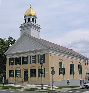
Bennington County courthouse in Manchester
|
|

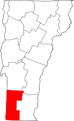
Location within the U.S. state of Vermont
|
|
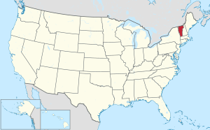
 Vermont's location within the U.S. |
|
| Country | |
| State | |
| Founded | 1778 |
| Named for | Benning Wentworth |
| Shire Town | Bennington & Manchester |
| Largest town | Bennington |
| Area | |
| • Total | 678 sq mi (1,760 km2) |
| • Land | 675 sq mi (1,750 km2) |
| • Water | 2.7 sq mi (7 km2) 0.4%% |
| Population
(2020)
|
|
| • Total | 37,347 |
| • Density | 55.08/sq mi (21.268/km2) |
| Time zone | UTC−5 (Eastern) |
| • Summer (DST) | UTC−4 (EDT) |
| Congressional district | At-large |
Bennington County is a county in the state of Vermont. It's located in the southwestern part of the state. In 2020, about 37,347 people lived here. The county has two main towns where the government offices are: Bennington (often called "The Southshire") and Manchester (known as "The Northshire"). Bennington is also the largest town in the county. Bennington County was created in 1778, making it a very old part of Vermont's history.
Contents
History of Bennington County
Bennington County is the oldest county in Vermont that is still around today. It was officially created on March 17, 1778, by Vermont's first general assembly. At that time, Vermont was divided into just two original counties: Bennington in the west and Unity (which soon became Cumberland) in the east.
Over the years, the county's shape changed a bit. For example, in 1781, Rutland County was formed from part of Bennington County. Later that year, Bennington County gained a small piece of land from Windham and Windsor Counties. This area is now known as Landgrove.
For a short time, from 1781 to 1782, Vermont tried to add a part of New York to its territory. This area was east of the Hudson River. People there liked Vermont's way of organizing towns. Vermont hoped this would give them more power. However, New York kept control of its land. So, for about seven months, Bennington County briefly overlapped with a part of Albany County, New York.
More changes happened in the late 1700s and early 1800s. In 1787, Windham County took the town of Stratton from Bennington County. Then, in 1805, Rutland County gained the town of Mount Tabor from Bennington County. But Bennington County also gained a small area from Mount Tabor in 1825, which went to the town of Dorset.
Geography of Bennington County
Bennington County covers a total area of about 678 square miles. Most of this is land, about 675 square miles. The rest, about 2.7 square miles (or 0.4%), is water.
Counties Nearby
Bennington County shares its borders with several other counties:
- To the north: Rutland County
- To the northeast: Windsor County
- To the east: Windham County
- To the southeast: Franklin County, Massachusetts
- To the south: Berkshire County, Massachusetts
- To the southwest: Rensselaer County, New York
- To the northwest: Washington County, New York
Protected Natural Areas
Part of the beautiful Green Mountain National Forest is located in Bennington County. Also, a section of the White Rocks National Recreation Area is here. These areas offer great opportunities for outdoor activities and enjoying nature.
People of Bennington County
| Historical population | |||
|---|---|---|---|
| Census | Pop. | %± | |
| 1790 | 12,206 | — | |
| 1800 | 14,617 | 19.8% | |
| 1810 | 15,893 | 8.7% | |
| 1820 | 16,125 | 1.5% | |
| 1830 | 17,468 | 8.3% | |
| 1840 | 16,872 | −3.4% | |
| 1850 | 18,589 | 10.2% | |
| 1860 | 19,436 | 4.6% | |
| 1870 | 21,325 | 9.7% | |
| 1880 | 21,950 | 2.9% | |
| 1890 | 20,448 | −6.8% | |
| 1900 | 21,705 | 6.1% | |
| 1910 | 21,378 | −1.5% | |
| 1920 | 21,577 | 0.9% | |
| 1930 | 21,655 | 0.4% | |
| 1940 | 22,286 | 2.9% | |
| 1950 | 24,115 | 8.2% | |
| 1960 | 25,088 | 4.0% | |
| 1970 | 29,282 | 16.7% | |
| 1980 | 33,345 | 13.9% | |
| 1990 | 35,845 | 7.5% | |
| 2000 | 36,994 | 3.2% | |
| 2010 | 37,125 | 0.4% | |
| 2020 | 37,347 | 0.6% | |
| U.S. Decennial Census 1790–1960 1900–1990 1990–2000 2010–2018 |
|||
In 2010, there were 37,125 people living in Bennington County. Most of the people (about 96.6%) were white. Other groups included Black (0.8%), Asian (0.7%), and American Indian (0.3%). About 1.4% of the population was of Hispanic or Latino background.
Many families live in Bennington County. In 2010, about 27.4% of households had children under 18 living with them. The average age of people in the county was about 45 years old.
Education in Bennington County
Bennington County is home to several colleges and high schools. Bennington College is a well-known college located here. The Community College of Vermont and Vermont Technical College also have campuses in downtown Bennington, offering different study programs.
Here are some of the high schools in Bennington County:
- Mount Anthony Union High School in Bennington
- Burr & Burton Academy in Manchester
- Arlington Memorial School in Arlington
- Long Trail School in Dorset
- Grace Christian School in Bennington, Vermont
Law Enforcement
Several police departments and sheriff's offices help keep Bennington County safe. Local police departments include:
- Bennington Police Department
- Manchester Police Department
- Winhall Police Department
The Bennington County Sheriff's Department and the Vermont State Police also provide law enforcement services throughout the county, especially in towns that don't have their own local police.
Transportation
Main Roads
Many important roads run through Bennington County, connecting its towns and linking it to other areas. These include:
 US 7
US 7 VT 7A
VT 7A VT 8
VT 8 VT 9
VT 9 VT 11
VT 11 VT 30
VT 30 VT 67
VT 67 VT 67A
 VT 100
 VT 153
 VT 279
 VT 313
 VT 315
 VT 346
div col end}}
Bus Services
The Green Mountain Community Network provides bus services in Bennington County. Their "Green Mountain Express" buses have routes in and around Bennington. They also have commuter routes connecting Bennington to Manchester, Wilmington, and even Williamstown, Massachusetts. Another bus service, the "MOOver" bus, serves Readsboro.
You can also find regional bus lines that connect Bennington to Albany, New York. There are also buses that link Manchester to Rutland. For longer trips, "Vermont Translines" (a partner of Greyhound) stops in Bennington and Manchester on its route between Albany and Burlington. The Shires Connector bus also connects Manchester and Bennington to Albany, New York's train station and airport.
Air Travel
For air travel, William H. Morse State Airport is a small airport near downtown Bennington. It's mainly used for private planes. For bigger flights, people usually go to Albany International Airport in New York or Rutland Southern Vermont Regional Airport in Rutland County.
Communities in Bennington County
Bennington County is made up of many different towns and villages.
Towns
- Arlington
- Bennington (one of the county seats)
- Dorset
- Glastenbury
- Landgrove
- Manchester (one of the county seats)
- Peru
- Pownal
- Readsboro
- Rupert
- Sandgate
- Searsburg
- Shaftsbury
- Stamford
- Sunderland
- Winhall
- Woodford
Villages
Census-Designated Places
These are specific areas identified by the census for data collection.
- Arlington
- Bennington
- Dorset
- East Dorset
- Manchester Center
- North Pownal
- Pownal
- Pownal Center
- Readsboro
- South Shaftsbury
- Stamford
- Stratton Mountain (partly in Windham County)
Other Communities
- Bondville
See also
 In Spanish: Condado de Bennington para niños


