Broome County, New York facts for kids
Quick facts for kids
Broome County
|
|||
|---|---|---|---|

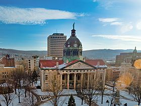
Broome County Courthouse
|
|||
|
|||

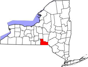
Location within the U.S. state of New York
|
|||
 New York's location within the U.S. |
|||
| Country | |||
| State | |||
| Founded | 1806 | ||
| Named for | John Broome | ||
| Seat | Binghamton | ||
| Largest city | Binghamton | ||
| Area | |||
| • Total | 715.52 sq mi (1,853.2 km2) | ||
| • Land | 705.77 sq mi (1,827.9 km2) | ||
| • Water | 9.7 sq mi (25 km2) 1.4% | ||
| Population
(2020)
|
|||
| • Total | 198,683 | ||
| • Density | 281.6/sq mi (108.7/km2) | ||
| Time zone | UTC−5 (Eastern) | ||
| • Summer (DST) | UTC−4 (EDT) | ||
| Congressional district | 19th | ||
Broome County is a place in New York. It's like a big district or area within the state. In 2020, about 198,683 people lived here. The main city and government center is Binghamton.
The county got its name from John Broome. He was the lieutenant governor of New York when the county was created. Broome County is part of a region in New York called the Southern Tier. It's also part of the larger Binghamton metropolitan area.
One important place in Broome County is Binghamton University. It's a big college and one of the main universities in the State University of New York (SUNY) system.
Contents
History of Broome County
When New York first created counties in 1683, the area that is now Broome County was part of a huge county called Albany County. This original Albany County was enormous. It covered a large part of New York State. It even included all of what is now the state of Vermont.
Over many years, Albany County was made smaller. In 1772, it was split into three parts. One new part was called Tryon County. This county covered the western part of New York. It was named after William Tryon, who was the governor at the time.
After the American Revolutionary War ended in 1784, the name of Tryon County was changed. It became Montgomery County. This new name honored General Richard Montgomery. He was a hero who fought in the war.
More changes happened over time. In 1791, Tioga County was created from part of Montgomery County. At first, Tioga County was much larger than it is today. It included the land that would later become Broome County.
Finally, on March 28, 1806, Broome County was officially formed. It was created by taking several towns from Tioga County. A few small changes to its borders happened in the following years. By 1822, Broome County had its current shape and size.
Geography of Broome County

Broome County is located on the southern edge of New York State. Its southern border touches the state of Pennsylvania. The Susquehanna River flows through the eastern part of the county. It then goes into Pennsylvania before coming back into Broome County. The river then flows northwest to meet the Chenango River in Binghamton.
The western part of the county has many hills and wide valleys. These valleys are where Binghamton and its nearby towns are located. In the northern part, Interstate 81 runs through a wide valley shaped by glaciers. The eastern part of the county is more rugged. The land there rises towards the Catskill Mountains.
The highest point in Broome County is about 2,087 feet (636 meters) above sea level. It's on an unnamed hill in the Town of Sanford. The lowest point is 864 feet (263 meters) above sea level. This is along the Susquehanna River at the Pennsylvania border.
The county covers a total area of about 716 square miles (1,850 square kilometers). Most of this is land, with about 9.7 square miles (25 square kilometers) being water.
Neighboring Counties
- Chenango County – northeast
- Delaware County – east
- Wayne County, Pennsylvania – southeast
- Susquehanna County, Pennsylvania – south
- Tioga County – west
- Cortland County – northwest
Protected Natural Areas
Broome County has several protected natural areas. These are places where nature is kept safe. They include:
- Aqua-Terra Wilderness Area
- Beaver Flow State Forest (part)
- Beaver Pond State Forest
- Cascade Valley State Forest
- Cat Hollow State Forest
- Chenango Valley State Park
- Dorchester County Park
- Greenwood County Park (part)
- Hawkins Pond State Forest
- Marsh Pond State Forest
- Nathaniel Cole County Park
- Oquaga Creek State Park (part)
- Skyline Drive State Forest
- Triangle State Forest
- Whitney Point Multiple Use Area (part)
- Whittacker Swamp State Forest
Lakes in Broome County
You can find many lakes in Broome County. Some of them are:
- Agwaterra Pond
- Blueberry Lake
- Chenango Lake
- Deer Lake
- Fly Pond
- Hawkins Pond
- Hust Pond
- Laurel Lake
- Lily Lake
- Nanticoke Lake
- Oquaga Lake
- Otselic River
- Potato Creek
- Sky Lake
- Summit Lake
Main Roads
Many important roads run through Broome County. These highways help people travel around the area and to other states.
Population Changes
The number of people living in Broome County has changed a lot over the years. Here's how the population has grown and changed since 1810:
| Historical population | |||
|---|---|---|---|
| Census | Pop. | %± | |
| 1810 | 8,130 | — | |
| 1820 | 14,343 | 76.4% | |
| 1830 | 17,579 | 22.6% | |
| 1840 | 22,338 | 27.1% | |
| 1850 | 30,660 | 37.3% | |
| 1860 | 35,906 | 17.1% | |
| 1870 | 44,103 | 22.8% | |
| 1880 | 49,483 | 12.2% | |
| 1890 | 62,973 | 27.3% | |
| 1900 | 69,149 | 9.8% | |
| 1910 | 78,809 | 14.0% | |
| 1920 | 113,610 | 44.2% | |
| 1930 | 147,022 | 29.4% | |
| 1940 | 165,749 | 12.7% | |
| 1950 | 184,698 | 11.4% | |
| 1960 | 212,661 | 15.1% | |
| 1970 | 221,815 | 4.3% | |
| 1980 | 213,648 | −3.7% | |
| 1990 | 212,160 | −0.7% | |
| 2000 | 200,536 | −5.5% | |
| 2010 | 200,600 | 0.0% | |
| 2020 | 198,683 | −1.0% | |
| U.S. Decennial Census 1790–1960 1900–1990 1990–2000 2010 2020 |
|||
2020 Census Information
In 2020, the population of Broome County was 198,683 people. The census also collects information about different groups of people living in the county.
| Race / Ethnicity | Pop 2010 | Pop 2020 | % 2010 | % 2020 |
|---|---|---|---|---|
| White alone (NH) | 173,074 | 156,173 | 86.28% | 78.60% |
| Black or African American alone (NH) | 8,850 | 11,547 | 4.41% | 5.81% |
| Native American or Alaska Native alone (NH) | 328 | 413 | 0.16% | 0.21% |
| Asian alone (NH) | 7,019 | 9,337 | 3.50% | 4.70% |
| Pacific Islander alone (NH) | 60 | 64 | 0.03% | 0.03% |
| Some other race alone (NH) | 242 | 864 | 0.12% | 0.43% |
| Mixed race/multi-racial (NH) | 4,249 | 10,000 | 2.12% | 5.03% |
| Hispanic or Latino (any race) | 6,778 | 10,285 | 3.38% | 5.18% |
| Total | 200,600 | 198,683 | 100.00% | 100.00% |
Note: The US census counts Hispanic/Latino people as an ethnic group. This means they can be of any race.
Climate
Broome County has a climate with warm summers. It's known as a humid continental climate. This means it has four distinct seasons. The area is mainly in hardiness zone 5b, which helps gardeners know what plants can grow there.
| Weather chart for Binghamton, New York | |||||||||||||||||||||||||||||||||||||||||||||||
|---|---|---|---|---|---|---|---|---|---|---|---|---|---|---|---|---|---|---|---|---|---|---|---|---|---|---|---|---|---|---|---|---|---|---|---|---|---|---|---|---|---|---|---|---|---|---|---|
| J | F | M | A | M | J | J | A | S | O | N | D | ||||||||||||||||||||||||||||||||||||
|
2.5
29
16
|
2.3
32
17
|
3
41
25
|
3.4
54
36
|
3.6
66
46
|
4.3
74
55
|
3.7
78
60
|
3.5
77
58
|
3.6
68
51
|
3.3
57
40
|
3.3
45
31
|
2.8
33
21
|
||||||||||||||||||||||||||||||||||||
| temperatures in °F precipitation totals in inches |
|||||||||||||||||||||||||||||||||||||||||||||||
|
Metric conversion
|
|||||||||||||||||||||||||||||||||||||||||||||||
Education
Broome County has several places for higher education. These are colleges and universities where students can continue their learning after high school.
- Binghamton University (about 18,500 students)
- Broome Community College (also known as BCC or SUNY Broome)
- Davis College – This was a private Christian college in Johnson City, but its campus is now closed.
Communities
Broome County is made up of many different communities. These include cities, villages, and towns.
Largest Communities
Here are some of the biggest places to live in Broome County by population:
| # | Location | Population | Type | Area |
|---|---|---|---|---|
| 1 | †Binghamton | 47,376 | City | Greater Binghamton |
| 2 | Johnson City | 15,174 | Village | Greater Binghamton |
| 3 | Endicott | 13,392 | Village | Greater Binghamton |
| 4 | Endwell | 11,446 | CDP | Greater Binghamton |
| 5 | Chenango Bridge | 2,883 | Hamlet/CDP | Greater Binghamton |
| 6 | ‡Deposit | 1,663 | Village | East |
| 7 | Port Dickinson | 1,641 | Village | Greater Binghamton |
| 8 | Whitney Point | 964 | Village | North |
| 9 | Windsor | 916 | Village | East |
| 10 | Glen Aubrey | 485 | CDP | North |
| 11 | Lisle | 320 | Village | North |
† – This is the county seat, where the main government offices are.
‡ – This community is not entirely within Broome County.
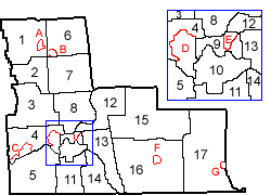
Towns in Broome County
Broome County is divided into several towns:
Notable People from Broome County
Many interesting people have come from or lived in Broome County. Here are a few:
- John Allen, a dentist who invented a new way to make dentures.
- Ira Cook (1821–1902), a land surveyor and businessman.
- Daniel S. Dickinson (1800–1866), who was a US Senator.
- John Ducey (born 1969), an actor.
- Johnny Hart (1931–2007), a famous cartoonist. He created the comic strips B.C. and The Wizard of Id.
- George F. Johnson (1857–1948), a business leader and giver to charity. He helped start the Endicott-Johnson Co.
- Edwin A. Link (1904–1981), an inventor.
- Ron Luciano (1937–1995), a baseball umpire and author.
- Billy Martin (1928–1989), a baseball player and manager.
- Camille Paglia (born 1947), a writer and thinker.
- Alice Freeman Palmer (1855–1902), an important educator.
- Amy Sedaris (born 1961), an actress and writer.
- David Sedaris (born 1956), a comedian and writer.
- Rod Serling (1924–1975), a famous screenwriter and playwright. He created The Twilight Zone.
- Jack Sharkey (1902–1994), a world heavyweight boxing champion.
See also
 In Spanish: Condado de Broome para niños
 | Madam C. J. Walker |
 | Janet Emerson Bashen |
 | Annie Turnbo Malone |
 | Maggie L. Walker |


