Butler County, Kansas facts for kids
Quick facts for kids
Butler County
|
|
|---|---|

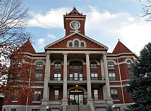
Butler County Courthouse in El Dorado (2011)
|
|

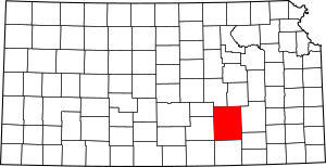
Location within the U.S. state of Kansas
|
|
 Kansas's location within the U.S. |
|
| Country | |
| State | |
| Founded | August 25, 1855 |
| Named for | Andrew Pickens Butler |
| Seat | El Dorado |
| Largest city | Andover |
| Area | |
| • Total | 1,447 sq mi (3,750 km2) |
| • Land | 1,430 sq mi (3,700 km2) |
| • Water | 17 sq mi (40 km2) 1.2% |
| Population
(2020)
|
|
| • Total | 67,380 |
| • Estimate
(2021)
|
67,889 |
| • Density | 47.1/sq mi (18.2/km2) |
| Time zone | UTC−6 (Central) |
| • Summer (DST) | UTC−5 (CDT) |
| Area code | 316 |
| Congressional district | 4th |
Butler County is a large county in the state of Kansas, USA. It's the biggest county in Kansas by total land area. The main city, or county seat, is El Dorado. The city with the most people is Andover. In 2020, about 67,380 people lived here. The county was named after Andrew Butler, a U.S. Senator. He helped write an important law called the Kansas–Nebraska Act.
Contents
History of Butler County
How Butler County Started
For thousands of years, Native Americans lived on the Great Plains. They moved around a lot. In the 16th to 18th centuries, France claimed much of North America. Later, France gave some land to Spain.
In 1803, the United States bought a huge area of land from France. This was called the Louisiana Purchase. It included most of what is now Kansas. Later, in 1848, more land was added after a war with Spain. In 1854, the area became the Kansas Territory. Kansas officially became the 34th U.S. state in 1861.
Butler County in the 1800s
Butler County was created in 1855. It was named after Andrew Butler, a U.S. Senator from South Carolina. He was important in creating the Kansas-Nebraska Act of 1854. This law allowed people in new territories to decide if they wanted slavery. Senator Butler wanted Kansas to be a state where slavery was allowed.
In the late 1800s, railroads started to connect towns. In 1877, a train line was built from Florence to El Dorado. It later went to Douglass and Arkansas City. This helped people and goods travel easily. Another big railroad, the "Rock Island," also built lines through the county. These trains were very important for growing towns and businesses.
Butler County in the 2000s
In 2010, a large oil pipeline called the Keystone-Cushing Pipeline was built. It runs through Butler County. There were some worries about its impact on the environment.
A funny tech story happened in Butler County too. For a while, a farm near Potwin became the default location for millions of internet addresses. This was due to a small mistake by a digital mapping company. It meant that if an internet address couldn't be pinpointed, it would show up as this farm!
Geography of Butler County
Butler County covers about 1,447 square miles. Most of this is land (1,430 square miles). A small part, about 17 square miles, is water. This makes it the largest county in Kansas by land area.
Neighboring Counties
Butler County shares borders with these counties:
- Chase County (to the northeast)
- Greenwood County (to the east)
- Elk County (to the southeast)
- Cowley County (to the south)
- Sumner County (to the southwest)
- Harvey County (to the west)
- Sedgwick County (to the west)
- Marion County (to the northwest)
Main Roads
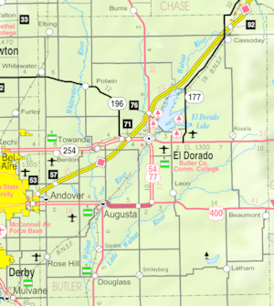
Several important highways run through Butler County. These roads help people travel and connect communities.
- Interstate 35
- U.S. Route 54
- U.S. Route 77
- Kansas Highway 96
- Kansas Highway 177
- Kansas Highway 196
- Kansas Highway 254
Population of Butler County
The population of Butler County has grown a lot over the years. Here's how it has changed:
| Historical population | |||
|---|---|---|---|
| Census | Pop. | %± | |
| 1860 | 437 | — | |
| 1870 | 3,035 | 594.5% | |
| 1880 | 18,586 | 512.4% | |
| 1890 | 24,055 | 29.4% | |
| 1900 | 23,363 | −2.9% | |
| 1910 | 23,059 | −1.3% | |
| 1920 | 43,842 | 90.1% | |
| 1930 | 35,904 | −18.1% | |
| 1940 | 32,013 | −10.8% | |
| 1950 | 31,001 | −3.2% | |
| 1960 | 38,395 | 23.9% | |
| 1970 | 38,658 | 0.7% | |
| 1980 | 44,782 | 15.8% | |
| 1990 | 50,580 | 12.9% | |
| 2000 | 59,482 | 17.6% | |
| 2010 | 65,880 | 10.8% | |
| 2020 | 67,380 | 2.3% | |
| 2023 (est.) | 68,632 | 4.2% | |
| U.S. Decennial Census 1790-1960 1900-1990 1990-2000 2010-2020 |
|||
Butler County is part of the Wichita Metropolitan Statistical Area. This means it's part of a larger area that includes Wichita and nearby counties.
Education in Butler County
Colleges
- Butler County Community College in El Dorado offers higher education.
Public School Districts
These are the public school districts that serve students in Butler County:
- Bluestem USD 205
- Remington USD 206
- Circle USD 375
- Andover USD 385
- Rose Hill USD 394
- Douglass USD 396
- Augusta USD 402
- El Dorado USD 490
- Flinthills USD 492
Some school districts have offices in neighboring counties but also serve parts of Butler County:
- Peabody–Burns USD 398
- Central USD 462
Private Schools
- Berean Academy in Elbing is a private school option.
Communities in Butler County
Butler County has many different types of communities, from busy cities to small, quiet areas.
Cities
- Andover
- Augusta
- Benton
- Cassoday
- Douglass
- Elbing
- El Dorado (This is the county seat, where the main government offices are.)
- Latham
- Leon
- Potwin
- Rose Hill
- Towanda
- Whitewater
Unincorporated Communities
These are smaller communities that are not officially organized as cities. Some are called Census-Designated Places (CDP), which means the U.S. Census Bureau tracks their population.
Ghost Towns
These are places where communities once existed but are now mostly abandoned.
- Aikman
- Alki
- Amador
- Browntown
- Chelsea (now under El Dorado Lake)
- Durachen
- Frazier
- Lorena
- Magna City
- Midian
- Oil Hill
- Oil Valley
- Ophir
- Plum Grove
- Providence
- Ramsey
- Salter
- Vanora
- Wingate
Townships
Butler County is divided into 29 townships. Townships are smaller areas within a county. The cities of Augusta and El Dorado are separate and not included in the township populations.
| Township | Population center |
Population |
|---|---|---|
| Augusta | 1,405 | |
| Benton | Benton | 2,211 |
| Bloomington | 544 | |
| Bruno | Andover | 9,744 |
| Chelsea | 190 | |
| Clay | 83 | |
| Clifford | 259 | |
| Douglass | Douglass | 2,306 |
| El Dorado | 1,700 | |
| Fairmount | Elbing | 511 |
| Fairview | 491 | |
| Glencoe | 239 | |
| Hickory | 90 | |
| Lincoln | 317 | |
| Little Walnut | Leon | 1,002 |
| Logan | 154 | |
| Milton | Whitewater | 1,136 |
| Murdock | 378 | |
| Pleasant | Rose Hill (part) | 4,649 |
| Plum Grove | Potwin | 661 |
| Prospect | 2,033 | |
| Richland | Rose Hill (part) | 2,399 |
| Rock Creek | 299 | |
| Rosalia | 589 | |
| Spring | 1,566 | |
| Sycamore | Cassoday | 333 |
| Towanda | Towanda | 2,727 |
| Union | Latham | 226 |
| Walnut | 760 |
See also
 In Spanish: Condado de Butler (Kansas) para niños
 | Kyle Baker |
 | Joseph Yoakum |
 | Laura Wheeler Waring |
 | Henry Ossawa Tanner |


