
Calvià facts for kids
Quick facts for kids
Calvià
|
||
|---|---|---|

|
||
|
||

Calvià shown within Majorca
|
||

Calvià
Location in Majorca

Calvià
Location in Balearic Islands

Calvià
Location in Spain
|
||
| Sovereign state | ||
| Autonomous community | ||
| Province | ||
| Island | ||
| Comarca | Serra de Tramuntana | |
| Administrative HQ | Calvià Vila | |
| Government | ||
| • Type | Municipal corporation | |
| • Body | Ajuntament de Calvià | |
| Area | ||
| • Total | 145.02 km2 (55.99 sq mi) | |
| Elevation | 154 m (505 ft) | |
| Population
(2018)
|
||
| • Total | 49,333 | |
| • Density | 340.181/km2 (881.06/sq mi) | |
| Time zone | UTC+1 (Central European Time) | |
| • Summer (DST) | UTC+2 (Central European Summer Time) | |
| Website | www.calvia.com | |
_2.svg)
Calvià is a town and a municipality (like a county) on the island of Majorca. Majorca is part of the Balearic Islands, which is an autonomous community of Spain. Calvià is located in the southwest of Majorca. It sits between two mountain ranges, the Serra de Tramuntana and the Serra de Na Burguesa. The main town where the local government is located is Calvià Vila.
Calvià covers about 145 square kilometers (56 square miles). To the north, it borders the towns of Puigpunyent and Estellencs. To the east, it's next to Palma de Mallorca, the island's capital. Andratx is to the west, and the Mediterranean Sea is to the south.
In 2008, about 50,777 people lived here. Many of them (over 18,000) were from other countries. Today, Calvià is the second most populated area in the Balearic Islands, after Palma. It also welcomes the most tourists on the islands. Its people live in different towns that grew because of tourism.
A very important event in Calvià's history was when King James I of Aragon landed in Santa Ponça on September 10, 1229. He then conquered the Muslims who had taken over the island in 903. Since 1248, Calvià has had its own church, Sante Ihoannes Caviano. Calvià uses an official shield, but it does not have its own flag.
Contents
What's in a Name?
The name Calvià probably comes from a Latin word, calvianum. This word might be from a personal name, Calvius. Some experts think it comes from the word Caluus, meaning "burn" or "be hot." This could describe the dry land without much plant life. The official name is Calvià (with a grave accent), but in Spanish, it's often written as Calviá (with an acute accent).
People from Calvià are officially called calvianenc (male) or calvianenca (female). However, in both Catalan and Spanish, people often say calvianer or calvianera.
Calvià's Coat of Arms
Calvià does not have a flag, but it has a special coat of arms. This shield is blue and shows a lamb holding a flag with a St George's Cross. A crown sits on top of the shield. This coat of arms was officially approved on June 25, 1976.
A Look Back: Calvià's History
Early Times

Calvià first appears in history as a village about 2,000 years before Christ. However, people lived in this area even earlier, during the Neolithic Era (New Stone Age). Later, sailors from the east visited the Balearic Islands on their way to Spain. They were looking for metals. These sailors came from Italy, other Mediterranean islands, and the Near East. They built small settlements along the coast.
Historians call this time the "Cave Culture" because people often lived and buried their dead in caves. You can still see some signs of this time at the Puig de sa Morisca Archaeological Park. This park has remains of an old tower called a talaiot, which was about 9 meters (30 feet) wide. It's on a small hill in Calvià's Santa Ponsa area.
The Roman Empire ruled from 123 BCE until the 4th century CE. Not many Roman remains are left. Some include a Roman villa in Santa Ponça called Sa Mesquida, which had an oven for making ceramics.
In 425 CE, the Vandals invaded and settled in the area. Not much is known about this time. The Byzantine general Flavius Belisarius conquered the islands in 534 CE, ending the Vandal rule. The first Muslims arrived in 707 CE. They quickly took over from the Byzantines. Until 903 CE, the island was part of the Umayyad Caliphate.
The Middle Ages

In 903 CE, the general Isam al-Jawlani conquered the island for the Caliphate of Córdoba. Calvià was part of an area called Juz' d' Ahwaz al-Madina.
In 1229, King James I of Aragon conquered Majorca. New settlers brought the Catalan language and culture, which are still present today. Calvià was given to Berenguer de Palou, the Bishop of Barcelona. This meant it became part of the Bishop's land.
Most of the new settlers came from Catalonia. This is why the local language, Mallorquí, is a dialect of eastern Catalan. Since 1248, Calvià has had its own church, Sante Ihoannes Caviano, dedicated to John the Baptist. In 1285, during the reign of James II of Aragon, Calvià became a villa (a town with its own mayor). The mayor would carry out orders from the king and keep public order.

During the Middle Ages, many watchtowers were built along the coast. These towers helped defend against pirates from the Mediterranean Sea.
Modern Times

From the 1200s until the mid-1900s, the Calvià region was mostly farmland. People lived off the land, which was often dry and not very fertile. Even though there was a long coastline, people didn't rely on the sea for their living. Most of the land was owned by a few wealthy families. In 1863, about 66% of the land was owned by just four people.
In the 16th century, Calvià mostly avoided the plague that affected other areas. However, people still suffered from other illnesses like malaria. In the 18th century, a bad drought and poor harvests led to a long period of famine. Life was very hard for many people.
In the late 1800s, hunger and poverty caused many people to move away. They went to places like Cuba, Argentina, France, and Algeria to find a better life. Calvià didn't have many factories back then, only some for cement and plaster.
In 1923, workers in Calvià formed unions to improve their lives. The Spanish Socialist Workers' Party even opened a community center. The labor movement was important during the Second Spanish Republic, but it was stopped during the Spanish Civil War.
Recent History


The start of modern tourism began in 1838 when steamboat service started from Barcelona to Palma. This made it easier for people to visit Mallorca. Some came to see the beautiful coves and beaches. Mallorca became a popular place for travelers, artists, and geographers.
In 1962, Calvià was a small town with basic shops and services. Its few industries included cement factories and some farming businesses. The first tourist areas started to grow in 1920. By 1960, much of the coast was quickly developed with hotels and resorts. Some of the last big landowners became involved in building these new tourist areas. By 1986, Calvià had 10,000 holiday homes called chalets.
On July 30, 2009, there was a bomb attack in the Palmanova area by a group called ETA. Two members of the Civil Guard were killed.
Exploring Calvià's Geography
Where is Calvià?

Calvià is in the western part of Majorca, near the Serra de Tramuntana mountains. It also stretches to the Sierra de Na Burguesa. Calvià covers about 145 square kilometers. Most of this land (81%) is protected countryside. About 18% is developed urban land.
The highest point in Calvià is the Puig de Galatzó, which is 1,026 meters (3,366 feet) above sea level. The second highest is the Mola del Esclop, at 926 meters (3,038 feet). This area has many valleys and ravines.
Calvià's coastline is about 54 kilometers (34 miles) long. It's very rocky but has 34 beaches and coves. There are also 10 small islands nearby. The most important islands for nature are the Malgrats and El Toro. They are protected as marine reserves and special areas for birds.
Towns and Villages

The municipality of Calvià has eighteen towns and villages. The most well-known are the tourist resorts. Palma Nova was one of the first resorts built on the island. It started as a plan for a garden city. Today, it is one of Majorca's most important tourist areas. Next to it is Magaluf, which has many hotels and services for tourists.
Santa Ponsa is important historically because King James I of Aragon landed there. Portals Nous is a popular meeting spot for business people, celebrities, and even members of the Spanish Royal Family during their summer visits. Another main tourist area is Peguera, popular with German tourists. Other notable areas include El Toro, which has a marina and a small beach, and Son Ferrer.
| Settlement | Population | Coordinates |
|---|---|---|
| Calvià Vila | 2434 | 39°33′50.33″N 2°30′16.31″E / 39.5639806°N 2.5045306°E |
| Es Capdellà | 1012 | 39°34′44.19″N 2°28′10.37″E / 39.5789417°N 2.4695472°E |
| Peguera | 3988 | 39°32′15.47″N 2°27′1.69″E / 39.5376306°N 2.4504694°E |
| Santa Ponsa | 10736 | 39°31′0.56″N 2°28′52.30″E / 39.5168222°N 2.4811944°E |
| Galatzó | 1598 | 39°31′25.42″N 2°29′53.09″E / 39.5237278°N 2.4980806°E |
| El Toro | 2321 | 39°29′20.73″N 2°28′51.29″E / 39.4890917°N 2.4809139°E |
| Portals Vells | 32 | 39°29′44.57″N 2°28′19.36″E / 39.4957139°N 2.4720444°E |
| Son Ferrer | 5666 | 39°29′41.24″N 2°30′7.24″E / 39.4947889°N 2.5020111°E |
| La Porrassa | 128 | 39°30′2.21″N 2°30′59.32″E / 39.5006139°N 2.5164778°E |
| Sol de Mallorca | 589 | 39°28′55.10″N 2°31′36.50″E / 39.4819722°N 2.5268056°E |
| Magaluf | 3981 | 39°30′29.97″N 2°32′6.33″E / 39.5083250°N 2.5350917°E |
| Palma Nova | 6906 | 39°31′14.03″N 2°32′10.34″E / 39.5205639°N 2.5362056°E |
| Portals Nous | 2650 | 39°31′59.68″N 2°34′12.08″E / 39.5332444°N 2.5700222°E |
| Castell de Bendinat | 521 | 39°32′0″N 2°32′10.08″E / 39.53333°N 2.5361333°E |
| Cas Català Ses Illetes | 3533 | 39°32′27.04″N 2°35′36.18″E / 39.5408444°N 2.5933833°E |
| Costa de la Calma | 1623 | 39°31′30.79″N 2°28′30.12″E / 39.5252194°N 2.4750333°E |
| Costa de Blanes | 2094 | 39°32′24.41″N 2°33′41.12″E / 39.5401139°N 2.5614222°E |
Mountains and Land
The land in Calvià is a mix of mountains in the north and flatter areas elsewhere. The main mountain range is the Serra de Na Burguesa. It has an average height of 500 meters (1,640 feet) and is covered in pine forests and scrubland. These hills are made of limestone and dolomite.
The rest of Calvià is mostly flat, with wide valleys and small hills. The coastline is made of calcareous materials.
Weather in Calvià
Calvià has a mild Mediterranean climate. The average yearly temperature is 19°C (66°F). It gets about 410 mm (16 inches) of rain each year. Summers are hot and dry, while winters are cool and wet. January is the coldest month, and August is the hottest. It rains about 51 days a year, and there are about 2,756 hours of sunshine. The average summer temperature is 27°C (81°F), and in winter, it's 14°C (57°F).
The sea temperature changes by about 15°C (27°F) throughout the year. In winter, it drops to about 13°C (55°F). In summer, the top layer of water can reach over 25°C (77°F).
Water Sources
Calvià gets a lot of rain, about 4.9 million cubic meters (6.4 million cubic yards) per year. There's also water from irrigation and treated wastewater. About 6.7 million cubic meters (8.8 million cubic yards) of water are pumped each year for people to use.
Ravines
Majorca has many ravines, which are narrow channels that carry rainwater to the sea, especially after heavy rains in October and November. Some of these include the Torrente des Gorg, which starts in Es Capdellà and flows into the sea at Peguera. The Torrente de Galatzó is one of the longest, running for 23 kilometers (14 miles). It starts in the mountains and reaches the sea at Santa Ponsa Bay.
Plants and Animals


More than 49% of Calvià's land is covered in woods and garrigues (low, bushy scrubland). Pine trees are the most common trees. About 32% of the land is farmed. The main crops are almonds, carobs, olives, and figs. Some cereals and grains are also grown.
Even though many people live here, Calvià has some interesting wild animals. The rocky shores and islands like Cala Figuera and the Malgrats are important for wildlife. The European Commission recognizes this area as a Special Protection Area for birds. In 2008, a very rare monk seal was seen here. There are only about 500 monk seals left in the world. The local government is thinking about bringing more monk seals back to the islands.
Common native plants include holm oak and different types of pine trees. There are over 1,000 animal species. You can see seabirds like Cory's shearwater and cormorants. There are also many reptiles, such as the unique Lilford's wall lizard found on the small islands. These islets are also home to one of Spain's few groups of Hermann's tortoise.
The cliffs have special plants like the Hippocrepis balearica and the "cliff carnation". These cliffs are also home to raptors like Eleonora's falcon and osprey. The world's only remaining island cinereous vultures (black vultures) also live here. You can also find two types of snails, Cornu aspersum and Helix pomatia.
After the autumn rains, many mushrooms grow. One special mushroom is Lactarius sangifluus, known locally as esclata-sang. It's very popular in local cooking because of its unique taste.
The forest plants in Calvià can be divided into four groups:
- Herbaceous plants: These include nettles, fiddle dock, fennel, and heather. There are also five unique types of Limonium plants in the salty soils of Magaluf.
- Shrubs: Common shrubs are the Mediterranean buckthorn, rosemary, thyme, and different types of asparagus. Protected species include the Mediterranean fan palm and myrtles.
- Ferns: You can find ferns in cooler, shaded areas.
- Trees: The most common tree is the Aleppo pine. These trees sometimes get a moth called the pine processionary. Special teams work to control these moths. In the northern part of Calvià, you can also find holm oak, white poplar, and strawberry trees.
Who Lives in Calvià?
Most people living in Calvià are either Spaniards from mainland Spain (especially from Andalusia) or their descendants. Many of them moved to the island in the early 1960s. There are also many foreign immigrants. In 2008, Calvià had 50,777 residents. About 25,548 were male and 25,229 were female. Calvià has the second-highest population in the Balearic Islands, after Palma.
In 2017, the population was 49,063, including 14,822 non-Spanish people. The total population reached over 50,000 in 2008 but has been slightly decreasing since 2015.
Age Groups in Calvià
| Population pyramid 2008 | ||||
| % | Males | Age | Females | % |
| 0.35 | 85+ | 0.63 | ||
| 0.49 | 80–84 | 0.72 | ||
| 0.80 | 75–79 | 0.89 | ||
| 1.35 | 70–74 | 1.37 | ||
| 1.88 | 65–69 | 1.79 | ||
| 2.71 | 60–64 | 2.49 | ||
| 3.30 | 55–59 | 3.11 | ||
| 3.87 | 50–54 | 3.57 | ||
| 4.32 | 45–49 | 4.22 | ||
| 4.35 | 40–44 | 4.60 | ||
| 4.41 | 35–39 | 4.38 | ||
| 4.57 | 30–34 | 4.51 | ||
| 4.23 | 25–29 | 4.20 | ||
| 3.15 | 20–24 | 3.01 | ||
| 2.76 | 15–19 | 2.59 | ||
| 2.57 | 10–14 | 2.63 | ||
| 2.70 | 5–9 | 2.67 | ||
| 2.48 | 0–4 | 2.29 | ||
Looking at the population pyramid, we can see:
- About 21% of the people are under 20 years old.
- About 32% are between 20 and 39 years old.
- Another 32% are between 40 and 59 years old.
- About 15% are 60 years old or older.
This shows that Calvià's population is slowly getting older, which is common in many parts of Western Europe.
Tourism in Calvià
Calvià is home to many of Majorca's main tourist areas. These include Magaluf, Santa Ponsa, El Toro, Peguera, Illetes, Portals Nous, and Palmanova. The area has six tourist zones with 60 kilometers (37 miles) of coastline, 27 beaches, 4 sports ports, and 120,000 tourist accommodations.
Because Palma is close and has good roads, you can reach the city center in about 15 minutes. Calvià welcomes about 1.6 million tourists each year. It is considered one of the wealthiest municipalities in Europe based on how much money is spent on public services per person. In the early 1960s, Calvià began building a full infrastructure for tourism, including many hotels. Later, more attractions were added, such as four professional golf courses, water parks, and a modern walkway called Paseig Calvià.
The 2004 World Chess Olympiad (a big chess tournament) was held in Calvià.

Images for kids
-
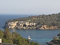
Cala de Portals Vells (cove), where stone blocks for La Seu Cathedral were sourced.

See also
 In Spanish: Calviá para niños
