
Cameron County, Texas facts for kids
Quick facts for kids
Cameron County
|
|||
|---|---|---|---|

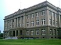
The Cameron County Courthouse in Brownsville Administration Building
|
|||
|
|||

Location within the U.S. state of Texas
|
|||
 Texas's location within the U.S. |
|||
| Country | |||
| State | |||
| Founded | 1848 | ||
| Named for | Ewen Cameron | ||
| Seat | Brownsville | ||
| Largest city | Brownsville | ||
| Area | |||
| • Total | 1,276 sq mi (3,300 km2) | ||
| • Land | 891 sq mi (2,310 km2) | ||
| • Water | 386 sq mi (1,000 km2) 30% | ||
| Population
(2020)
|
|||
| • Total | 421,017 | ||
| • Density | 329.95/sq mi (127.39/km2) | ||
| Time zone | UTC−6 (Central) | ||
| • Summer (DST) | UTC−5 (CDT) | ||
| Congressional district | 34th | ||

Cameron County is the southernmost county in Texas. It is also officially known as the County of Cameron. In 2020, about 421,017 people lived there. The main city, or county seat, is Brownsville.
The county was started in 1848. It is named after Captain Ewen Cameron. He was a soldier in the Texas Revolution. Later, a place called Fort Brown helped the city of Brownsville grow.
Cameron County is part of the larger Rio Grande Valley region. The second-largest city in the county is Harlingen.
The county is home to the SpaceX Starbase spaceport. This spaceport is located in Boca Chica.
Contents
Where is Cameron County?
Cameron County covers a total area of about 1,276 square miles. About 891 square miles of this is land. The other 386 square miles (30%) are covered by water. To the east, the county touches the Gulf of Mexico.
Main Roads and Highways
Many important roads run through Cameron County. These include:
 Interstate 2
 Interstate 69E/U.S. Highway 77
 Interstate 169/State Highway 550
 U.S. Highway 83
 U.S. Highway 281
 State Highway 4
 State Highway 48
 State Highway 100
 State Highway 107
 State Highway 345
Neighboring Areas
Cameron County shares borders with:
- Willacy County (to the north)
- Gulf of Mexico (to the east)
- Matamoros Municipality, Tamaulipas, Mexico (to the south)
- Hidalgo County (to the west)
Protected Natural Areas
Some parts of Cameron County are protected natural areas. These include:
- Laguna Atascosa National Wildlife Refuge
- Lower Rio Grande Valley National Wildlife Refuge
- Palo Alto Battlefield National Historical Park
People of Cameron County
| Historical population | |||
|---|---|---|---|
| Census | Pop. | %± | |
| 1850 | 8,541 | — | |
| 1860 | 6,028 | −29.4% | |
| 1870 | 10,999 | 82.5% | |
| 1880 | 14,959 | 36.0% | |
| 1890 | 14,424 | −3.6% | |
| 1900 | 16,095 | 11.6% | |
| 1910 | 27,158 | 68.7% | |
| 1920 | 36,662 | 35.0% | |
| 1930 | 77,540 | 111.5% | |
| 1940 | 83,202 | 7.3% | |
| 1950 | 125,170 | 50.4% | |
| 1960 | 151,098 | 20.7% | |
| 1970 | 140,368 | −7.1% | |
| 1980 | 209,680 | 49.4% | |
| 1990 | 260,120 | 24.1% | |
| 2000 | 335,227 | 28.9% | |
| 2010 | 406,220 | 21.2% | |
| 2020 | 421,017 | 3.6% | |
| U.S. Decennial Census 1850–2010 2010 2020 |
|||
In 2010, there were 406,220 people living in Cameron County. The population density was about 370 people per square mile. Most people in the county are of Hispanic or Latino background.
The average household had about 3.36 people. The average family had about 3.80 people. About 33% of the people were under 18 years old. The median age was 30.6 years.
In recent years, some northern cities in the county have grown faster. This suggests that more people might want to live away from the busiest city centers. For example, Los Fresnos grew by over 42% from 2010 to 2018. Other cities like Indian Lake and Primera also grew a lot.
Education in Cameron County
Several school districts serve the students of Cameron County. These include:
- Brownsville Independent School District
- Harlingen Consolidated Independent School District
- La Feria Independent School District
- Los Fresnos Consolidated Independent School District
- Lyford Consolidated Independent School District (partially)
- Point Isabel Independent School District
- Rio Hondo Independent School District
- San Benito Consolidated Independent School District
- Santa Maria Independent School District
- Santa Rosa Independent School District
Students can also apply to special magnet schools run by the South Texas Independent School District. All areas of the county are served by Texas Southmost College for higher education.
Economy and Space Exploration
Cameron County has been known as one of the poorer urban counties in the U.S. However, new projects are bringing changes.
The FAA (Federal Aviation Administration) approved a private spaceport for SpaceX here. It is located east of Brownsville on the Gulf Coast. This site is called the SpaceX South Texas Launch Site. It is expected to create many full-time jobs. In 2014, SpaceX bought more land near Boca Chica. They named this area "Mars Crossing".
Media
Radio Stations
- KFRQ 94.5FM
- KKPS 99.5FM
- KNVO 101.1FM
- KVLY 107.9FM
- KVMV 96.9FM
Newspapers
- The Brownsville Herald
- Valley Morning Star
- El Nuevo Heraldo
Communities
Cities
- Brownsville (county seat)
- Harlingen
- La Feria
- Los Fresnos
- Palm Valley
- Port Isabel
- Rio Hondo
- San Benito
Towns
Village
Census-Designated Places (CDPs)
These are areas identified by the census bureau for statistical purposes.
- Arroyo Colorado Estates
- Arroyo Gardens
- Bixby
- Bluetown
- Cameron Park
- Chula Vista
- Del Mar Heights
- El Camino Angosto
- Encantada-Ranchito-El Calaboz
- Green Valley Farms
- Iglesia Antigua
- Juarez
- La Feria North
- La Paloma
- La Tina Ranch
- Lago
- Laguna Heights
- Las Palmas II
- Lasana
- Laureles
- Lozano
- Olmito
- Orason
- Palmer
- Ratamosa
- Reid Hope King
- Rice Tracts
- San Pedro
- Santa Maria
- Solis
- South Point
- Tierra Bonita
- Villa del Sol
- Villa Pancho
- Yznaga
Other Communities (Unincorporated)
- Adams Gardens
- Arroyo Alto
- Arroyo City
- Boca Chica (to be incorporated as "Starbase")
- Buena Vista
- Carricitos
- Cavazos
- Holly Beach
- La Penusca
- Landrum
- Lantana
- Las Yescas
- Los Cuates
- Monte Grande
- Russelltown
- Villa Nueva
Ghost Towns
These are towns that no longer have people living in them.
- Del Mar
- La Leona
- Las Rusias
- Santa Rita
- Stuart Place
Images for kids
-
A picture of the Cameron County Courthouse (1912), the Dancy Building, in Brownsville, Texas. It was the County Courthouse until a new one was built. It was restored in 2006.

See also
 In Spanish: Condado de Cameron (Texas) para niños
