
Collingwood, Queensland facts for kids
Quick facts for kids CollingwoodQueensland |
|
|---|---|

Collingwood
Location in Queensland
|
|
| Population | <-- no census available 2016, 2021 --> |
| Established | ~1878 |
| Abolished | ~1900 |
| Elevation | 252 m (827 ft) |
| Time zone | AEST (UTC+10:00) |
| LGA(s) | Shire of Winton |
Collingwood was once a small town in the Channel Country of Central West Queensland, Australia. It's located in the Shire of Winton. The town started in the 1870s. People hoped it would grow into a big center for raising animals in the Diamantina area. This industry is still very important there today. However, Collingwood didn't succeed and was abandoned after only about 20 years. It is now known as a ghost town.
Exploring Collingwood's Location
Where Was Collingwood Located?
Collingwood was about 11 km up the Western River from where it joins the Diamantina River. This spot is about 52 km west of Winton. Both rivers here are braided, meaning they split into many smaller streams that weave together. This is why the Channel Country got its name. Wokingham Creek also meets the Diamantina here, feeding the Conn Waterhole (22°17′56″S 142°28′44″E / 22.299°S 142.479°E). This waterhole is shaped like a hook and changes size depending on the rain. Drought (very dry weather) is common in this area.
The land around Collingwood is mostly flat grassland with Mitchell grass. There are a few small hills nearby, like Mount Booka Booka and Mount Munro. The old townsite is still shown on many maps. It's on the Diamantina River Road, and there's a short road leading to what was once the Collingwood Cemetery. Many sheep and cattle stations are within 70 km of Collingwood, some of which existed when the town was active.
- Satellite Views of Collingwood's Location
-
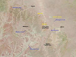
This picture from December 2008 shows the Collingwood area looking dry.
-
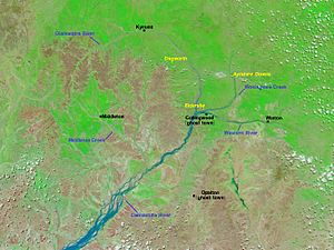
Just two months later, in February 2009, the area looks wetter and greener. This happened after a drought.
-
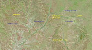
Flooding in January 2010 made the land green, especially near the rivers. The colors are stronger because NASA used both visible and infrared light.


Rocks, Fossils, and Ancient Life
Collingwood was also located in the Great Artesian Basin, a huge underground water supply. The area's geology includes the Cretaceous Winton Formation. This rock layer has given up many fossils. For example, in 2005, scientists found Early Cretaceous dinosaur remains of Australovenator and Diamantinasaurus matildae at the "Matilda site" near the old town, on Elderslie Station (roughly 22°12′S 142°30′E / 22.2°S 142.5°E).
A "major fault" (a crack in the Earth's crust) called the Cork Fault passes southeast of Collingwood. It runs from northeast to southwest. Robert Logan Jack, a government geologist, wrote a report in 1892. He noted that the area near Collingwood had grey sandstones and silicified wood (wood turned to stone). He also found coal seams in the region.

Could an Asteroid Have Struck Here?
Scientists have noticed something interesting about the Diamantina River's shape. In 2015, Geoscience Australia reported that the river flows along the edge of a huge circular area, about 130 km wide. This area might be an impact structure from an asteroid impact that happened about 300 million years ago. The Collingwood site is right on its eastern edge.
Natural Environment of Collingwood
The Collingwood site is part of the Galilee subregion, which is within the larger Lake Eyre Basin bioregion. This means it shares similar plants, animals, and climate with these areas.
Collingwood's Past
First Peoples of the Land
Before Europeans arrived, the Diamantina River was like a natural highway for Indigenous Australians. Groups like the Maiawali and Karuwali used it for trade. They exchanged things like boomerangs, shields, and pituri for yellow ochre and stone for tools.
The Collingwood area has a semi-arid climate, meaning it's often dry. Early European attempts to settle here sometimes failed because of droughts. However, Indigenous people have lived in the Channel Country for thousands of years. They survived thanks to "permanent waterholes and periodic pulses of substantial water" from rain. The Conn Waterhole, which doesn't dry up, was important for them.
In 2015, the Koa people (also known as Goamalku) made a native title claim. They wanted their traditional rights to be recognized in an area that included Winton, Elderslie Station, and the Conn Waterhole (Collingwood's old site). Their claim showed how their ancestors used the land for food, resources, and trade. For example, they traded gidgee wood spears and boomerangs with other tribes. Even though Collingwood is a ghost town, it's marked on the map of the Koa people's ancestral homeland.
Early European Journeys

It's possible that Burke and Wills passed near Collingwood's future site in 1860 during their famous expedition. However, other accounts suggest they took a different route.
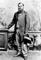
What's more certain is that John McKinlay's expedition, which was looking for Burke and Wills, came very close to Collingwood's future site in 1862. His Camp 32 was near the Conn Waterhole, which he called "Kell's Creek" and noted had "plenty of water."
William Landsborough also explored the Western and Diamantina rivers in the 1860s. He likely visited their meeting point.
The first non-Indigenous person to find the Conn Waterhole was William Conn in the early 1860s. The waterhole was named after him. Sadly, he and his wife were later murdered by Indigenous Australians in another part of Queensland.
In 1876, William Hodgkinson led an expedition that passed by the future townsite. By this time, much of the land west to the Diamantina was already known to White settlers. Hodgkinson's goal was to find out how much land was good for grazing in the area.
In 1877, a Mr. Shives surveyed the "Diamantina Country." He suggested reserving land for a "township" near Conn's Waterhole. This recommendation likely led to Collingwood being established. He also praised the area, saying "Large stations are being taken up daily."
- Explorers and mappers in the Collingwood area
-
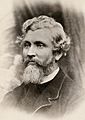
John McKinlay
-
William Landsborough
-
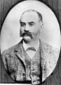
William Hodgkinson
-
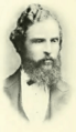
Robert Logan Jack


Starting the Town
The idea for Collingwood didn't quite work out from the start. William Henry Corfield, who later became the mayor of Winton, explained this. He and his friends planned to open a business in Collingwood. But when they arrived, they decided it would be better to start a town further east, near the Pelican Waterholes. This new town became Winton, which would eventually become Collingwood's rival and win.
Corfield mentioned that Collingwood was also known as the Conn Waterhole. He said the government surveyor had laid out the town about 64 km west of Winton. Another businessman, Thomas Lynett, also went to Collingwood to set up a shop. But he decided the land was too likely to flood. He turned back, and he, Corfield, and others decided to start Winton instead. This was the beginning of Winton and the end of Collingwood's hopes.
Newspapers also reported concerns about flooding at Collingwood. One writer said people didn't want to build there because it was "twenty feet below flood-mark." They correctly predicted that Winton would become the main business center.
The pastoral industry in the Collingwood area focused on sheep and cattle. In 1879, a news article reported good lambing on local stations, thanks to a "most splendid" season. Another article from 1877 said that within two years of the first animals arriving, "every mile of available country has been secured and partially stocked." These positive reports likely encouraged the decision to found Collingwood.
Collingwood's Beginning and Challenges
In its early days, not many people knew about Collingwood. One writer in 1878 was confused to hear that mail service was planned for "Conn's Waterhole," a place he thought was uninhabited. However, plans for the new town were moving forward.
More definite news came in March 1878, saying a township would be officially declared at Conn Waterhole. The official proclamation came in October 1878. It simply stated a "reserve" for township purposes on the Western River, named Collingwood. This date is different from the Collingwood Cemetery Marker, which says the town started in 1874.
By early 1880, buildings were definitely going up in Collingwood. A news item mentioned that Winton was growing fast with hotels, stores, and butchers. It also said Collingwood was "going ahead" with three houses almost finished, planned as hotels. The writer thought the two towns would help each other. However, Winton clearly had a head start.
The 1881 census showed Collingwood had only nine people (eight male, one female). Winton had 146 people. In 1882, land was put up for sale in Collingwood, but the sale was held in Winton, which showed Winton's growing importance.
Heavy rains in 1881 caused floods, washing out some dams, including one at Elderslie, "near the township of Collingwood." This made travel difficult.
A map from 1885 showed Collingwood's name in italics, while Winton's name was handwritten, suggesting it was not on the official maps at first. However, Cobb and Co's stagecoach route went to Winton, bypassing Collingwood. Collingwood did get a weekly horse-borne mail service between Winton and Boulia that year. A postal receiving office was set up in Collingwood in April 1885.
The 1886 Queensland Census did not report a population for Collingwood, suggesting it was already struggling.
In 1887, a man named Mr. Roydell had an accident while trying to swim across the Western River at Collingwood. His horse was swept away and drowned.
A happier story happened in 1895 when a boy named Fleetwood, thought to have drowned in floods near Elderslie, was found alive near Collingwood. He had survived for eleven days without food, spending seven of them up a tree.
By 1890, the postal service to Collingwood was still weekly and by horse. The Australian native police post nearby had been abandoned by 1882.
The Great Shearers' Strike affected the wool industry in 1891. Many stations in the Collingwood area were declared "non-union." Later, the woolshed at nearby Elderslie Station was burned down.
In January 1894, a major storm brought much-needed rain, causing the Western and Diamantina rivers to flow strongly. News reported "Splendid rain has fallen... particularly in the vicinity of Collingwood."
Later in 1894, the Second Shearers' Strike brought more trouble. A large haystack at Elderslie Station was set on fire, and the shearing shed at Dagworth Station was burned down by strikers. This strike likely hurt Collingwood's economy.
In 1893, a man named Harry Ward was convicted of killing a 16-year-old Indigenous boy named Charlie near Elderslie after drinking in Collingwood. A constable tracked Ward for 256 km. Ward was found guilty of manslaughter and sentenced to 15 years of hard labor.
The 1901 census listed Collingwood as having a population under 100, but didn't say it was abandoned yet.
People of Collingwood
We know little about Collingwood's residents, mostly from the eight burial records at the cemetery. Two babies named Tranby were buried there. Their parents, Peter and Bridget Tranby, were mentioned in an 1890 newspaper report about a horse and buggy accident on the road from Winton to Collingwood. The buggy crashed, throwing everyone out, but no one was badly hurt. This suggests Peter Tranby was in Winton for business, showing Winton was already becoming the main business center.
The Tranby children, Reginald Francis and James Patrick, died as infants. Reginald was born in Collingwood, while James was born at nearby Ayrshire Downs. Another baby, an unnamed son of Thomas and Sarah Jane Toombs, lived only seven hours.
Some people buried in Collingwood came from far away. Thomas Gravestock and Richard Fitzgerald were from England. James Driscoll and Patrick Phair were from Ireland.
William Paget died in December 1891 but wasn't buried until May 1892, with no explanation. The cemetery plaque suggests there are likely more unknown burials.
In 1897, a newspaper mentioned Mr. Louis Webber, "formerly of the Western Hotel at Collingwood," had left for the south. Peter Tranby also moved to Cairns and died there in 1918. His wife, Bridget, died in 1898 from burns. They had six children, but only two lived to adulthood.
A storyteller named Hazelton Brock claimed that Collingwood had at least one Indigenous inhabitant named Boomerang Jack. Brock said he had kidnapped Jack as a boy after a massacre at Skull Hole in the 1870s and raised him.
W. T. Strutton planned to open The St. Helen's Hotel in Collingwood in 1879, but it's unknown if he ever did. Historical records mention two hotels in Collingwood, but not that name. One was the Western Hotel, and Mrs. G. Martin ran the Bushman's Arms Hotel. Mick Cunningham was also said to be a hotel owner in Collingwood. "Old Crawley" from Aramac was an innkeeper who may have chosen the town's location even before the official survey.
Collingwood Horse Races
Collingwood held horse races that attracted small crowds, even with some people coming from Winton. The first races were held at "Conn Hole" on October 1 and 2, 1878, by the "Never Never Amateur Jockey Club." Attendance was "pretty good," especially since many station workers were busy sheep shearing.
In 1885, races were held again on October 1 and 2. About 60 to 70 people attended, including some from Winton and Elderslie. The town had two hotels and a small store, with only a few "calico houses" (tents or simple fabric structures). The event ended with a camel race, which was very popular. The winning bets were settled at Mrs. G. Martin's Bushman's Arms Hotel.
Races were also held on Saint Patrick's Day in 1887. The main race was won by Anonyma, owned by Mr. Macpherson of Dagworth. He was a big fan of horse racing and is often linked to the famous song "Waltzing Matilda".
Another Saint Patrick's Day race meeting in 1889 had few spectators and horses, possibly due to dry weather. The settling-up was done at the Welcome Hotel. The weather was "very hot and dry," with the land "completely bare for miles." One of the horses, Disraeli, was owned by P. Tranby, likely the same Peter Tranby mentioned earlier.
In 1890, there was trouble at the Collingwood races. A newspaper reported "plenty of rowdyism" and many "drunks," leading to several arrests, despite police presence. This happened after recent flooding had made travel difficult for racegoers.
Collingwood's End
Drought was a constant problem. In 1895, a geologist named Robert Logan Jack thought Winton might run out of water. He suggested moving Winton's entire population and their animals to the Conn Waterhole at Collingwood. This never happened.
Even though an atlas in 1901 called the land around Collingwood "Excellent Country," the town never became a major center. This was mainly because of competition from Winton to the east. The railway reached Winton in 1899. Collingwood, which had never truly thrived, became a ghost town around 1900. Interestingly, a 1925 map showed a railway extension from Winton to Collingwood "under construction," but it was never built. If it had been, it might have saved Collingwood.
Collingwood Today
Today, no buildings are left standing at Collingwood. Satellite views show only natural Channel Country scenery. The old town is now part of the locality of Middleton, which is also a very small town.
Collingwood is remembered by the Collingwood Cemetery Marker. This stone with a plaque lists eight people known to be buried there. It's almost the only physical sign left of the town.
Even though Collingwood is gone, its location still appears on some maps and online mapping services. Some even show a small street grid with names. The Gazetteer of Australia still lists Collingwood as a "parish" and an "unbounded locality."
Collingwood's site is not completely forgotten. Tourist information for the Winton area suggests angling (fishing) at the Conn Waterhole, calling it a "pretty picnic spot." A 2010 study found fish like bony bream, silver tandan, and golden perch in the waterhole.
The name Collingwood is still used locally. The old townsite and Conn Waterhole are part of a pastoral property called the Collingwood Reserve. A local grazier (rancher) also owns a nearby property with the same name.
| Name | Position | Dist. (km) | Bearing | Remarks |
|---|---|---|---|---|
| Albrighton | 22°00′00″S 142°24′00″E / 22.000000000°S 142.399993896°E |
|
|
|
| Aldingham | 22°16′47″S 143°12′20″E / 22.279583757°S 143.205422279°E |
|
|
|
| Alni | 22°09′00″S 142°29′00″E / 22.149999618°S 142.483337402°E |
|
|
Sauropodomorpha fossils found here. |
| Amelia Downs | 22°03′00″S 142°33′00″E / 22.049999237°S 142.550003051°E |
|
|
|
| Apache Downs | 21°50′35″S 142°43′16″E / 21.843089388°S 142.721052382°E |
|
|
|
| Ascot | 21°44′00″S 142°31′00″E / 21.733329772°S 142.516662597°E |
|
|
|
| Athlestane | 22°47′00″S 142°57′00″E / 22.783330917°S 142.949996948°E |
|
|
|
| Ayrshire Downs | 21°58′00″S 142°43′00″E / 21.966669082°S 142.716674804°E |
|
|
James Patrick Tranby's birthplace. |
| Balranald | 22°21′00″S 142°43′00″E / 22.350000381°S 142.716674804°E |
|
|
|
| Belfield | 21°50′00″S 142°56′00″E / 21.833330154°S 142.933334350°E |
|
|
|
| Bendemeer | 21°54′00″S 142°25′00″E / 21.899999618°S 142.416671752°E |
|
|
|
| Bernfels | 21°56′00″S 142°38′00″E / 21.933330535°S 142.633331298°E |
|
|
|
| Bladensburg | 22°31′00″S 143°02′00″E / 22.516666412°S 143.033340454°E |
|
|
Now a national park. |
| Boolbie House | 22°10′24″S 141°55′41″E / 22.173300000°S 141.928000000°E |
|
|
|
| Brooklyn | 21°47′00″S 142°49′00″E / 21.783330917°S 142.816665649°E |
|
|
|
| Camara | 22°09′00″S 143°03′00″E / 22.149999618°S 143.050003051°E |
|
|
|
| Carella | 22°13′00″S 142°56′00″E / 22.216669082°S 142.933334350°E |
|
|
|
| Carisbrooke | 22°39′00″S 142°31′00″E / 22.649999618°S 142.516662597°E |
|
|
Site of Lyndon B. Johnson's 1942 emergency landing. |
| Castle Hill | 22°07′48″S 142°17′02″E / 22.129900000°S 142.283800000°E |
|
|
|
| Cathedral Hill | 22°00′00″S 142°12′00″E / 22.000000000°S 142.199996948°E |
|
|
|
| Colane | 22°25′00″S 142°44′00″E / 22.416669845°S 142.733337402°E |
|
|
|
| Collingwood | 22°21′00″S 142°33′00″E / 22.350000381°S 142.550003051°E |
|
|
A property near the old townsite. |
| Colston | 22°47′00″S 142°43′00″E / 22.783330917°S 142.716674804°E |
|
|
|
| Congewoi | 21°48′00″S 142°17′00″E / 21.799999237°S 142.283325195°E |
|
|
|
| Cooinda | 21°55′00″S 142°52′00″E / 21.916669845°S 142.866668701°E |
|
|
Site of an early, successful artesian bore (1896). |
| Cork | 22°55′31″S 142°18′40″E / 22.925296588°S 142.3110472848°E |
|
|
|
| Cotswold Hills | 22°33′00″S 142°40′00″E / 22.549999237°S 142.666671752°E |
|
|
|
| Dagworth | 21°52′00″S 142°09′00″E / 21.866670608°S 142.149993896°E |
|
|
Famous for Waltzing Matilda. |
| Donald Downs | 21°45′19″S 142°27′20″E / 21.755234860°S 142.455586746°E |
|
|
|
| Elderslie | 22°17′00″S 142°28′00″E / 22.283330917°S 142.466674804°E |
|
|
Existed when Collingwood was active. |
| Farewell | 21°56′00″S 142°20′00″E / 21.933330535°S 142.333328247°E |
|
|
|
| Gallipoli | 22°31′00″S 142°36′00″E / 22.516700000°S 142.600000000°E |
|
|
|
| Glenusk | 22°15′00″S 142°45′00″E / 22.250000000°S 142.750000000°E |
|
|
|
| Goolma | 22°22′00″S 142°35′00″E / 22.366670608°S 142.583328247°E |
|
|
|
| The Grove | 22°20′00″S 142°38′00″E / 22.333330154°S 142.633331298°E |
|
|
|
| Gurley Out Station | 22°13′00″S 142°24′00″E / 22.216700000°S 142.400000000°E |
|
|
|
| Hexham | 22°05′00″S 143°07′00″E / 22.083330154°S 143.116668701°E |
|
|
|
| Jarvisfield | 22°31′00″S 142°35′00″E / 22.516670227°S 142.583328247°E |
|
|
|
| Kalkadoon | 22°30′00″S 142°22′00″E / 22.500000000°S 142.366668701°E |
|
|
|
| Karoola | 22°05′00″S 142°30′00″E / 22.083330154°S 142.500000000°E |
|
|
|
| Lana Downs | 22°00′00″S 143°06′00″E / 22.000000000°S 143.100006103°E |
|
|
|
| Leeson | 22°11′00″S 142°45′00″E / 22.183330535°S 142.750000000°E |
|
|
|
| Lilford | 21°52′00″S 142°54′00″E / 21.866670608°S 142.899993896°E |
|
|
|
| Lovelle Downs | 22°09′00″S 142°32′00″E / 22.149999618°S 142.533325195°E |
|
|
Site of an exploratory oil well. |
| Mountain View | 22°27′00″S 143°09′00″E / 22.450000762°S 143.149993896°E |
|
|
|
| Mount Campbell | 21°58′00″S 142°29′00″E / 21.966669082°S 142.483337402°E |
|
|
|
| Myrall | 22°05′00″S 142°46′00″E / 22.083330154°S 142.766662597°E |
|
|
|
| Nadjayamba | 22°23′00″S 142°50′05″E / 22.383291656°S 142.834701828°E |
|
|
Site of a plane crash in 1966. |
| Namarva | 22°49′59″S 142°43′59″E / 22.833000000°S 142.733000000°E |
|
|
|
| Narangie | 22°16′00″S 142°39′00″E / 22.266670227°S 142.649993896°E |
|
|
|
| Nareen House | 22°47′00″S 142°28′00″E / 22.783330917°S 142.466674804°E |
|
|
|
| Nuken | 21°50′00″S 142°22′00″E / 21.833330154°S 142.366668701°E |
|
|
|
| Oondooroo | 22°10′00″S 143°09′00″E / 22.166669845°S 143.149993896°E |
|
|
Location for the film Banjo & Matilda. |
| Owens Creek | 22°23′00″S 142°26′00″E / 22.383329391°S 142.433334350°E |
|
|
|
| Prubi | 22°05′03″S 143°07′53″E / 22.084133148°S 143.131439208°E |
|
|
A railway station with a homestead nearby. |
| Rangelands | 22°16′00″S 143°03′00″E / 22.266670227°S 143.050003051°E |
|
|
|
| Robins | 22°10′00″S 142°20′00″E / 22.166669845°S 142.333328247°E |
|
|
|
| Strathbowen | 21°52′00″S 142°16′00″E / 21.866670608°S 142.266662597°E |
|
|
|
| Strathfillan | 22°07′00″S 142°51′00″E / 22.116670608°S 142.850006103°E |
|
|
|
| Suvla | 22°34′00″S 142°32′00″E / 22.566669464°S 142.533325195°E |
|
|
Named after a World War I battle. |
| Talkara | 21°55′00″S 142°45′00″E / 21.916669845°S 142.750000000°E |
|
|
|
| Tatong | 22°55′00″S 142°43′00″E / 22.916669845°S 142.716674804°E |
|
|
|
| Teviot | 22°14′00″S 142°47′00″E / 22.233329772°S 142.783325195°E |
|
|
|
| Thymania | 22°49′00″S 142°43′00″E / 22.816669464°S 142.716674804°E |
|
|
|
| Tranby | 22°40′00″S 142°24′00″E / 22.666669845°S 142.399993896°E |
|
|
|
| Tulmur | 22°39′00″S 142°15′00″E / 22.649999618°S 142.250000000°E |
|
|
|
| Warnambool Downs | 22°49′00″S 142°50′00″E / 22.816669464°S 142.833328247°E |
|
|
Once had opal mines. |
| Webb | 22°01′44″S 142°56′36″E / 22.028815631°S 142.943391292°E |
|
|
|
| Werna | 21°50′00″S 142°43′00″E / 21.833330154°S 142.716674804°E |
|
|
|
| Weston | 22°06′00″S 142°39′00″E / 22.100000381°S 142.649993896°E |
|
|
|
| Whyrallah | 22°46′00″S 142°22′00″E / 22.766670227°S 142.366668701°E |
|
|
|
| Winderere | 22°23′00″S 142°50′00″E / 22.383329391°S 142.833328247°E |
|
|
|
| Wongan | 21°48′00″S 142°33′00″E / 21.799999237°S 142.550003051°E |
|
|
|
| Woodstock | 22°16′00″S 141°57′00″E / 22.266670227°S 141.949996948°E |
|
|
|
| Wybenia | 21°48′00″S 142°36′00″E / 21.799999237°S 142.600006103°E |
|
|
See also
 In Spanish: Collingwood (Queensland) para niños
