Cumberland County, New Jersey facts for kids
Quick facts for kids
Cumberland County
|
|||
|---|---|---|---|
|
|||
|
|||
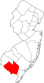
Location within the U.S. state of New Jersey
|
|||
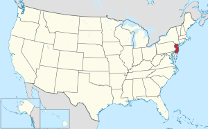 New Jersey's location within the U.S. |
|||
| Country | |||
| State | |||
| Founded | 1748 | ||
| Named for | Prince William, Duke of Cumberland | ||
| Seat | Bridgeton | ||
| Largest municipalities | Vineland (population) Maurice River Township (area) |
||
| Area | |||
| • Total | 677.85 sq mi (1,755.6 km2) | ||
| • Land | 483.36 sq mi (1,251.9 km2) | ||
| • Water | 194.49 sq mi (503.7 km2) 28.7% | ||
| Population
(2020)
|
|||
| • Total | 154,152 | ||
| • Estimate
(2023)
|
152,326 |
||
| • Density | 227.4131/sq mi (87.8047/km2) | ||
| Time zone | UTC−5 (Eastern) | ||
| • Summer (DST) | UTC−4 (EDT) | ||
| Congressional district | 2nd | ||
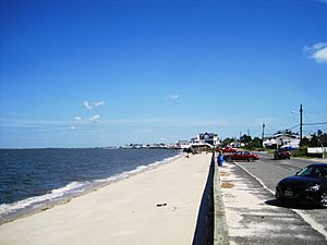
Cumberland County is a coastal county in New Jersey, located on the Delaware Bay. It is part of the Southern Shore Region of the state. In 2020, about 154,152 people lived here. This makes it the 16th most populated county in New Jersey.
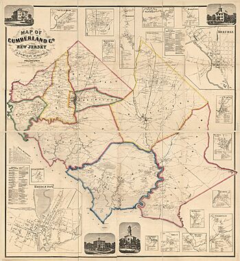
The county seat, which is like its main government town, is Bridgeton. Cumberland County was named after Prince William, Duke of Cumberland. It was officially created on January 19, 1748, from parts of Salem County.
The biggest city by population is Vineland, with over 60,000 people in 2020. The largest area is covered by Maurice River Township. This county is also part of a larger area called the Delaware Valley.
Contents
History of Cumberland County
Why the Name?
Cumberland County is named after Prince William, Duke of Cumberland. He was a famous British prince. He was well-known for helping to end a big uprising in Britain in 1746. This made him very popular in many places.
Early People and Life
The first people to live in Cumberland County were the Lenape. They are also known as the Delaware people. They are Native American people who have lived in New Jersey for a very long time.
Rivers like the Cohansey River and Maurice River made Cumberland County a great place to live. Early native groups used these water sources for food and travel. Scientists have found old tools and pottery in places like Bridgeton and Fairfield. These items show how people lived long ago.
Some of the oldest tools found are spear points from about 10,000 to 8,000 BC. Later, as the climate changed, the Lenape's ancestors started using axes. They also began making pottery. The time before Europeans arrived ended when new technologies came to the area. Today, many Lenape people still live in Cumberland County. This includes the Nanticoke tribe.
European Settlement and Growth
Europeans first settled here with the Swedish in the 1600s. They called the area New Sweden. Before the United States became independent, Cumberland County was separated from Salem County in 1748. It was then named after the Duke of Cumberland.
Cumberland County's economy was based on farming and making things. Farmers grew lots of fruits and vegetables. Factories made glass and preserved foods. Southern New Jersey became famous for glassmaking in the 1700s. Later, in the 1850s, John Landis Mason from Vineland invented the Mason jar. This jar helped people store and preserve food at home.
The county's population has always been diverse. In 1790, about 120 enslaved people lived here. By 1830, this number had dropped to two. Cumberland County had towns settled by Black Americans, many of whom had escaped slavery. Parts of the county were used as a safe route on the Underground Railroad. Famous people like Harriet Tubman helped others find freedom here.
Life on the Water
Besides farming and glass, Cumberland County was known for its water-based industries. Oysters were a major product until the 1950s. A disease then harmed the oyster population. With the oyster business, shipbuilding also started in 1780.
Later, the Industrial Revolution and railroads helped more ships to be built. By the late 1800s, ships changed from sloops to schooners. This made them better for oyster fishing.
Whaling was also an industry here until 1775. After that, settlers focused on raising animals, farming, and trapping. Caviar was a short-lived industry from the 1860s to 1925. This ended because too many sturgeon fish were caught. You can see old ship models, tools, and plans at the John Dubois Maritime Museum in Bridgeton.
Cumberland County's Geography
Cumberland County covers about 677 square miles. About 483 square miles are land, and 194 square miles are water. This means about 28.7% of the county is water.
Cumberland is a flat county near the coast. It has many salt marshes close to the Delaware Bay. The highest point is about 140 feet above sea level. The lowest point is at sea level.
Weather and Climate
| Weather chart for Bridgeton, New Jersey | |||||||||||||||||||||||||||||||||||||||||||||||
|---|---|---|---|---|---|---|---|---|---|---|---|---|---|---|---|---|---|---|---|---|---|---|---|---|---|---|---|---|---|---|---|---|---|---|---|---|---|---|---|---|---|---|---|---|---|---|---|
| J | F | M | A | M | J | J | A | S | O | N | D | ||||||||||||||||||||||||||||||||||||
|
3.6
41
25
|
2.9
44
28
|
4.3
52
34
|
4
63
43
|
3.8
73
53
|
4.2
82
63
|
4.1
87
68
|
4.1
85
66
|
4.3
78
59
|
3.6
67
47
|
3.3
56
39
|
4
45
30
|
||||||||||||||||||||||||||||||||||||
| temperatures in °F precipitation totals in inches source: The Weather Channel |
|||||||||||||||||||||||||||||||||||||||||||||||
|
Metric conversion
|
|||||||||||||||||||||||||||||||||||||||||||||||
In Bridgeton, the average temperature in January is about 25°F (about -4°C). In July, it's about 87°F (about 31°C). The coldest temperature ever recorded was -13°F (-25°C) in January 1985. The hottest was 101°F (38°C) in July 1966.
The county gets about 2.94 inches (7.5 cm) of rain in February. It gets the most rain in March, with about 4.30 inches (10.9 cm). Cumberland has a humid subtropical climate. This means it has hot, humid summers and mild winters.
People of Cumberland County
| Historical population | |||
|---|---|---|---|
| Census | Pop. | %± | |
| 1790 | 8,248 | — | |
| 1800 | 9,529 | 15.5% | |
| 1810 | 12,670 | 33.0% | |
| 1820 | 12,668 | 0.0% | |
| 1830 | 14,093 | 11.2% | |
| 1840 | 14,374 | 2.0% | |
| 1850 | 17,189 | 19.6% | |
| 1860 | 22,605 | 31.5% | |
| 1870 | 34,665 | 53.4% | |
| 1880 | 37,687 | 8.7% | |
| 1890 | 45,438 | 20.6% | |
| 1900 | 51,193 | 12.7% | |
| 1910 | 55,153 | 7.7% | |
| 1920 | 61,348 | 11.2% | |
| 1930 | 69,895 | 13.9% | |
| 1940 | 73,184 | 4.7% | |
| 1950 | 88,597 | 21.1% | |
| 1960 | 106,850 | 20.6% | |
| 1970 | 121,374 | 13.6% | |
| 1980 | 132,866 | 9.5% | |
| 1990 | 138,053 | 3.9% | |
| 2000 | 146,438 | 6.1% | |
| 2010 | 156,898 | 7.1% | |
| 2020 | 154,152 | −1.8% | |
| 2023 (est.) | 152,326 | −2.9% | |
| Historical sources: 1790-1990 1970-2010 2010 2020 |
|||
Census Information (2020)
In 2020, Cumberland County had 154,152 people. There were 51,360 households. The population density was about 318.7 people per square mile.
The people living here were from many different backgrounds:
- 45.4% White
- 18.0% African American
- 0.9% Native American
- 1.2% Asian
- 2.6% from two or more races
- 34.4% were Hispanic or Latino
About 26.8% of households had children under 18. The average household had 2.68 people. The average family had 3.30 people.
About 23.8% of the population was under 18. About 15.7% were 65 or older. The average age was 38.1 years. There were slightly more males than females.
The median household income was $54,587. This means half of the households earned more, and half earned less. About 13.2% of the people lived below the poverty line.
Economy
In 2021, the total value of goods and services produced in Cumberland County was about $5.9 billion. This was a 3.8% increase from the year before. This shows that the county's economy is growing.
Towns and Cities
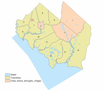
Cumberland County has 14 different towns and cities. Here is a list of them with some facts from the 2010 Census:
| Municipality (with map key) |
Map key | Municipal type |
Population | Housing Units |
Total Area |
Water Area |
Land Area |
Pop. Density |
Housing Density |
School District | Communities |
|---|---|---|---|---|---|---|---|---|---|---|---|
| Bridgeton | 3 | city | 27,263 | 6,782 | 6.43 | 0.25 | 6.18 | 4,102.5 | 1,097.6 | Bridgeton | |
| Commercial Township | 13 | township | 4,669 | 2,115 | 34.44 | 2.31 | 32.13 | 161.2 | 65.8 | Millville (9-12) (S/R) Commercial Township (PK-8) |
Buckshutem Laurel Lake CDP (2,861) Mauricetown CDP (403) Money Island CDP (22) Newport CDP (487) Port Norris CDP (1,111) |
| Deerfield Township | 9 | township | 3,136 | 1,143 | 16.80 | 0.03 | 16.76 | 186.1 | 68.2 | Cumberland Regional (9-12) Deerfield Township (PK-8) |
Rosenhayn CDP (1,150) |
| Downe Township | 12 | township | 1,399 | 996 | 54.27 | 5.66 | 48.61 | 32.6 | 20.5 | Bridgeton (9-12) (S/R) Downe Township (PK-8) |
Dividing Creek CDP (345) Fortescue CDP (189) Gandys Beach CDP (25) Newport |
| Fairfield Township | 10 | township | 5,546 | 2,058 | 43.95 | 2.69 | 41.26 | 152.6 | 49.9 | Cumberland Regional (9-12) Fairfield Township (PK-8) |
Fairton CDP (1,060) Gouldtown CDP (1,601) Sea Breeze |
| Greenwich Township | 6 | township | 771 | 369 | 18.83 | 1.00 | 17.84 | 45.1 | 20.7 | Cumberland Regional (9-12) Greenwich Township (K-8) |
Greenwich CDP (251) Othello CDP (132) Sheppards Mill CDP (part; 131) Springtown |
| Hopewell Township | 7 | township | 4,391 | 1,741 | 30.83 | 0.95 | 29.87 | 153.0 | 58.3 | Cumberland Regional (9-12) Hopewell Township (K-8) |
Bowentown Dutch Neck CDP (123) Lakeside-Beebe Run CDP (403) Roadstown CDP (part; 155) Sheppards Mill CDP (part; 131) West Park CDP (1,506) |
| Lawrence Township | 11 | township | 3,087 | 1,221 | 38.33 | 1.41 | 36.92 | 89.1 | 33.1 | Bridgeton (9-12) (S/R) Millville (9-12) (S/R) Lawrence Township (PK-8) |
Cedarville CDP (702) Centre Grove CDP (1,281) |
| Maurice River Township | 14 | township | 6,218 | 1,506 | 95.76 | 2.65 | 93.11 | 85.7 | 16.2 | Millville (9-12) (S/R) Maurice River Township (PK-8) |
Cumberland Cumberland-Hesstown CDP (315) Delmont CDP (122) Dorchester CDP (291) Heislerville CDP (227) Hesstown Leesburg CDP (601) Milmay CDP (part; 919) Port Elizabeth CDP (290) |
| Millville | 2 | city | 27,491 | 11,435 | 44.49 | 2.49 | 42.00 | 676.2 | 272.3 | Millville | |
| Shiloh | 4 | borough | 444 | 214 | 1.21 | 0.00 | 1.21 | 427.3 | 177.2 | Cumberland Regional (9-12) Hopewell Township (K-8) (S/R) |
|
| Stow Creek Township | 5 | township | 1,312 | 568 | 18.85 | 0.55 | 18.30 | 78.2 | 31.0 | Cumberland Regional (9-12) Stow Creek (K-8) |
Arrowhead Lake CDP (126) Jericho Marlboro CDP (127) Roadstown CDP (part; 155) |
| Upper Deerfield Township | 8 | township | 7,645 | 3,025 | 31.27 | 0.18 | 31.10 | 246.3 | 97.3 | Cumberland Regional (9-12) Upper Deerfield Township (PK-8) |
Carlls Corner CDP (911) Deerfield Deerfield Street CDP (230) Laurel Heights CDP (380) Seabrook Seabrook Farms CDP (1,508) Seeley CDP (152) Silver Lake CDP (1,435) Sunset Lake CDP (494) |
| Vineland | 1 | city | 60,780 | 22,661 | 69.03 | 0.61 | 68.42 | 887.5 | 331.2 | Vineland | |
| Cumberland County | county | 154,152 | 55,834 | 677.62 | 193.92 | 483.70 | 324.4 | 115.4 |
Getting Around Cumberland County
Airports
There are three public airports in Cumberland County:
- Bucks Airport (00N) in Bridgeton
- Millville Municipal Airport (MIV) in Millville
- Kroelinger Airport (29N) in Vineland
Roads and Highways
As of 2010, Cumberland County had over 1,271 miles of roads. Local towns maintained about 643 miles. The county itself took care of 539 miles. The state of New Jersey maintained about 88 miles.
Major county roads include County Route 540, 548, 550, 552, 553, and 555. State routes include Route 47, 49, 55, 56, 77, and 347. Route 55 is the only highway with limited exits. It connects the county to Interstate 76, Interstate 295, and the Philadelphia area.
Fun and Education
Parks and Recreation
The only YMCA in the county is the Cumberland Cape Atlantic YMCA in Vineland. In 2001, its name was changed. This was to include members from Atlantic County and Cape May County.
Wineries
- Cedar Rose Vineyards is a place where wine is made.
Schools in the County
Cumberland County has several school districts:
Schools for All Grades (K-12)
- Bridgeton Public Schools
- Millville Public Schools
- Salem County Special Services School District
- Vineland Public Schools
High Schools
- Cumberland County Vocational School District
- Cumberland Regional School District
Elementary Schools
- Commercial Township School District
- Deerfield Township School District
- Downe Township School District
- Fairfield Township School District
- Greenwich Township School District
- Hopewell Township School District
- Maurice River Township School District
- Stow Creek School District
- Upper Deerfield Township Schools
See also
 In Spanish: Condado de Cumberland (Nueva Jersey) para niños


