
Visalia, California facts for kids
Quick facts for kids
Visalia, California
|
||
|---|---|---|
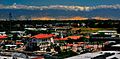
.jpg) .jpg) .jpg)  Clockwise: View of Visalia; Bank of Italy Tower; Visalia Transit Center; Fox Theatre
|
||
|
|
||
| Nickname(s):
Gateway to the Sequoias
|
||

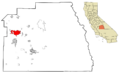
Location within Tulare County in the state of California
|
||

Visalia, California
Location in California

Visalia, California
Location in the United States
|
||
| Country | United States | |
| State | California | |
| County | Tulare | |
| Region | San Joaquin Valley | |
| Incorporated | February 27, 1874 | |
| Government | ||
| • Type | Council–manager | |
| Area | ||
| • Total | 37.94 sq mi (98.25 km2) | |
| • Land | 37.91 sq mi (98.20 km2) | |
| • Water | 0.02 sq mi (0.05 km2) 0.05% | |
| Elevation | 331 ft (101 m) | |
| Population
(2020)
|
||
| • Total | 141,384 | |
| • Rank | 40th in California 192nd in the United States |
|
| • Density | 3,726.52/sq mi (1,439.02/km2) | |
| Demonym(s) | Visalian | |
| Time zone | UTC−8 (PST) | |
| • Summer (DST) | UTC−7 (PDT) | |
| ZIP code |
93277-93279, 93290-93292
|
|
| Area code(s) | 559 | |
| FIPS code | 06-82954 | |
| GNIS feature IDs | 1652807, 2412160 | |
Visalia is a city in California, located in the agricultural San Joaquin Valley. In 2020, about 141,384 people lived there. Visalia is the fifth-largest city in the San Joaquin Valley. It is also the 40th most populated city in California and the 192nd in the United States. As the main city of Tulare County, Visalia is an important center for business and government. This county is one of the best for farming in the country.
Contents
History of Visalia
The area where Visalia is now was first home to the Yokuts and Mono Native American tribes. This was many hundreds of years ago. The first European to write about the area was Pedro Fages in 1722.
.jpg)
When California became a state in 1850, Tulare County did not yet exist. The land was part of a much larger area called Mariposa County. In 1852, some pioneers settled in the area, which they called Four Creeks. It got this name because of the many creeks and rivers flowing from the Sierra Nevada Mountains. All this water created a large swampy area with many oak trees.
The settlers asked the state government to make their area a county. On July 10, 1852, Tulare County was officially created.

One of the first people to live in a fort built by the settlers was Nathaniel Vise. He was in charge of mapping the new settlement. In November 1852, he wrote that the town had 60-80 people, including 30 children ready for school. He also said the town was on a branch of the Kaweah River and would become the county seat of Tulare. In 1853, his prediction came true. Visalia has been the county seat ever since. The city is named after Nathaniel Vise's family home, Visalia, Kentucky.
Visalia grew quickly because of the gold rush near the Kern River. Many gold miners passed through Visalia. When they didn't find gold, many came back to Visalia to live and raise families. In 1859, Visalia became a stop on John Butterfield's Overland Stage route. This route went from St. Louis to San Francisco. You can find a marker for this spot at 116 East Main Street.
The telegraph arrived in 1860. This allowed people in Visalia to get news faster from the East Coast. This news included updates about the Civil War. During the war, people in Visalia had different opinions about which side to support. There was even a small conflict on Main Street. In 1862, the government built Camp Babbitt to keep order and stop support for the Southern side. During these years, Visalia officially became an incorporated town, which gave it new rights.
In 1874, Visalia became a city with a city council and a mayor. In 1893, two train robbers, John Sontag and Chris Evans, were caught near Visalia. Sontag died later, and Evans was sent to prison. In 1904, the Visalia Electric Railroad was started.
In 1933, Visalia was part of an investigation into labor issues during a cotton strike. Later, in the mid-1970s, the area was known for a series of unsolved burglaries. More recently, Visalia hosted the Amgen Tour of California bike race in 2009 and 2010.
Geography and Climate
Visalia is shaped unevenly and covers about 36.3 square miles (94 square kilometers). Most of this area is land. Visalia is located at 36°19'27" North and 119°18'26" West.
The highest point in the Visalia area is Mount Whitney. It is about 58 miles (93 km) east of the city in the Sierra Nevada mountains. Mount Whitney is 14,505 feet (4,421 meters) tall. The hilliest parts near Visalia are the Venice Hills and the Sierra Nevada foothills.
Four main streams flow through the city. The largest is the St. John's River, which is mostly seasonal. Other streams include Mill Creek, Cameron Creek, and Packwood Creek. The Friant-Kern Canal runs just east of the city.
City Layout
Visalia is divided into different neighborhoods. Some of these used to be separate towns or communities. Other nearby cities are often thought of as part of the Visalia area. Generally, the city has these main parts: Downtown Visalia, North Visalia, the Eastside, Southwest Visalia, the Industrial Area, Mooney, and the Westside.
Weather in Visalia
Visalia has a semi-arid climate, which means it's usually dry. The city gets a lot of sunshine all year. On average, there are only 26 days with rain each year.
Visalia gets about 10.32 inches (262 mm) of rain annually. Most of this rain falls during winter and spring (November to April). It's usually light rain, but sometimes there are heavy rains or thunderstorms. Snowfall is very rare in Visalia. The most snow ever recorded was 2 inches (5 cm) on January 25, 1999.
| Climate data for Visalia, California, 1991–2020 normals, extremes 1898–present | |||||||||||||
|---|---|---|---|---|---|---|---|---|---|---|---|---|---|
| Month | Jan | Feb | Mar | Apr | May | Jun | Jul | Aug | Sep | Oct | Nov | Dec | Year |
| Record high °F (°C) | 80 (27) |
89 (32) |
90 (32) |
103 (39) |
108 (42) |
113 (45) |
115 (46) |
115 (46) |
110 (43) |
104 (40) |
94 (34) |
86 (30) |
115 (46) |
| Mean maximum °F (°C) | 66.7 (19.3) |
71.8 (22.1) |
78.8 (26.0) |
87.5 (30.8) |
94.5 (34.7) |
101.0 (38.3) |
101.9 (38.8) |
101.1 (38.4) |
97.7 (36.5) |
89.9 (32.2) |
77.0 (25.0) |
67.0 (19.4) |
103.4 (39.7) |
| Mean daily maximum °F (°C) | 55.3 (12.9) |
61.3 (16.3) |
66.9 (19.4) |
72.7 (22.6) |
80.6 (27.0) |
88.8 (31.6) |
93.8 (34.3) |
93.2 (34.0) |
88.3 (31.3) |
77.8 (25.4) |
64.4 (18.0) |
55.4 (13.0) |
74.9 (23.8) |
| Daily mean °F (°C) | 46.9 (8.3) |
51.4 (10.8) |
56.2 (13.4) |
60.6 (15.9) |
68.0 (20.0) |
75.1 (23.9) |
80.2 (26.8) |
79.0 (26.1) |
74.2 (23.4) |
65.1 (18.4) |
53.9 (12.2) |
46.6 (8.1) |
63.1 (17.3) |
| Mean daily minimum °F (°C) | 38.4 (3.6) |
41.6 (5.3) |
45.4 (7.4) |
48.6 (9.2) |
55.4 (13.0) |
61.5 (16.4) |
66.7 (19.3) |
64.9 (18.3) |
60.1 (15.6) |
52.3 (11.3) |
43.3 (6.3) |
37.9 (3.3) |
51.3 (10.8) |
| Mean minimum °F (°C) | 30.8 (−0.7) |
34.3 (1.3) |
37.6 (3.1) |
40.4 (4.7) |
47.7 (8.7) |
53.0 (11.7) |
61.1 (16.2) |
59.4 (15.2) |
52.8 (11.6) |
44.2 (6.8) |
35.4 (1.9) |
30.6 (−0.8) |
29.3 (−1.5) |
| Record low °F (°C) | 13 (−11) |
24 (−4) |
22 (−6) |
26 (−3) |
29 (−2) |
35 (2) |
40 (4) |
40 (4) |
32 (0) |
25 (−4) |
23 (−5) |
20 (−7) |
13 (−11) |
| Average precipitation inches (mm) | 1.96 (50) |
1.64 (42) |
1.82 (46) |
0.97 (25) |
0.36 (9.1) |
0.13 (3.3) |
0.00 (0.00) |
0.00 (0.00) |
0.07 (1.8) |
0.55 (14) |
0.99 (25) |
1.83 (46) |
10.32 (262.2) |
| Average snowfall inches (cm) | 0.1 (0.25) |
0.0 (0.0) |
0.0 (0.0) |
0.0 (0.0) |
0.0 (0.0) |
0.0 (0.0) |
0.0 (0.0) |
0.0 (0.0) |
0.0 (0.0) |
0.0 (0.0) |
0.0 (0.0) |
0.0 (0.0) |
0.1 (0.25) |
| Average precipitation days (≥ 0.01 in) | 7.5 | 6.9 | 6.6 | 3.7 | 2.1 | 0.7 | 0.0 | 0.1 | 0.4 | 1.9 | 3.6 | 6.4 | 39.9 |
| Average snowy days (≥ 0.1 in) | 0.0 | 0.0 | 0.0 | 0.0 | 0.0 | 0.0 | 0.0 | 0.0 | 0.0 | 0.0 | 0.0 | 0.0 | 0.0 |
| Source 1: NOAA | |||||||||||||
| Source 2: National Weather Service | |||||||||||||
Protecting Valley Oak Trees
Visalia has a special rule called the Valley Oak Ordinance, started in 1971. This rule helps protect valley oak trees. These trees were once very common in the area. The city wants to keep its healthy "urban forest." One way they do this is by protecting Mooney Grove Park. It is one of the biggest groups of valley oak trees in California.
Just outside the city, the Kaweah Oaks Preserve is a 322-acre (1.3 km²) nature area. It helps protect one of the last remaining valley oak forests near a river in the San Joaquin Valley.
The Visalia Rawhide Baseball Team
The Visalia Rawhide is a Minor League Baseball team. They play in the California League and are connected to the Arizona Diamondbacks. They have played their home games at Valley Strong Ballpark since 1946.
The team has had nine different names over the years. Most of these names changed when their main league team changed. They became the Rawhide in 2009.
Air Quality and the Environment
Visalia can have problems with air pollution like smog and tiny particles. This is because of its geography. The San Joaquin Valley often has "atmospheric inversions." This means a layer of warm air traps pollution from cars, planes, factories, and other sources close to the ground. Unlike other cities that get a lot of rain to clear the air, Visalia only gets about 11 inches (279 mm) of rain each year. This means pollution can build up for many days.
Because of air quality issues, laws like the Clean Air Act were created. California has also worked to reduce pollution by requiring cars to have low emissions. Pollution from particles can be high in winter due to these inversions. These inversions also cause thick fog, known as Tule fog.
Even with these challenges, pollution levels have improved a lot. The number of serious smog alerts has gone down from over 100 per year in the 1970s to almost zero now. Still, reports have ranked Visalia as one of the most polluted cities in the country for particle pollution.
People of Visalia
| Historical population | |||
|---|---|---|---|
| Census | Pop. | %± | |
| 1860 | 548 | — | |
| 1870 | 913 | 66.6% | |
| 1880 | 1,412 | 54.7% | |
| 1890 | 2,885 | 104.3% | |
| 1900 | 3,085 | 6.9% | |
| 1910 | 4,550 | 47.5% | |
| 1920 | 5,753 | 26.4% | |
| 1930 | 7,263 | 26.2% | |
| 1940 | 8,904 | 22.6% | |
| 1950 | 11,749 | 32.0% | |
| 1960 | 15,791 | 34.4% | |
| 1970 | 27,130 | 71.8% | |
| 1980 | 49,729 | 83.3% | |
| 1990 | 75,636 | 52.1% | |
| 2000 | 91,565 | 21.1% | |
| 2010 | 124,442 | 35.9% | |
| 2020 | 141,384 | 13.6% | |
| U.S. Decennial Census 1850–1870 1880-1890 1900 1910 1920 1930 1940 1950 1960 1970 1980 1990 2000 2010 |
|||
Population in 2020
In 2020, Visalia had a population of 141,384 people. The city is very diverse. About 35.76% of the people were White (not Hispanic or Latino). About 52.75% of the people were Hispanic or Latino (of any race). Other groups included Asian (5.41%), Black or African American (1.70%), and Native American (0.58%).
Population in 2010
In 2010, Visalia had 124,442 people. About 98.9% of the people lived in homes. The average household had 2.98 people. About 30.1% of the population was under 18 years old. The median age was 31.6 years. For every 100 females, there were about 95.2 males.
Religions in Visalia
Many different religions are practiced in Visalia. There are about 233,293 Christians in the Visalia area. This includes churches of the Catholic, Methodist, Presbyterian, Lutheran, Baptist, and other Christian groups. St. Charles Borromeo is the largest Catholic church in North America.
Visalia also has people practicing Judaism, Islam, Buddhism, Hinduism, and other faiths. Immigrants from Southeast Asia have built the Lao Buddhist Temple of Visalia.
Economy and Jobs
Visalia's economy is mainly based on agriculture. Important crops include grapes, olives, cotton, and citrus fruits. Raising livestock is also a big part of the economy. The city also has many distribution and manufacturing businesses. These include electronics and paper products. Light manufacturing and industrial distribution are the fastest-growing job areas in Visalia.
Top Employers in Visalia
Here are some of the largest employers in Visalia as of June 2023:
- Kaweah Delta Medical Center (4,550 employees)
- Tulare County (4,311 employees)
- Visalia Unified School District (2,988 employees)
- Visalia Mall (1,200 employees)
- VF Outdoor (1,012 employees)
- Walmart (840 employees)
- Graphic Packaging (757 employees)
- College of the Sequoias (705 employees)
- City of Visalia (676 employees)
- UPS (600 employees)
Arts and Culture
The Tulare County Public Library has its biggest branch, the Visalia Branch, in Downtown Visalia. There are also smaller libraries, like the Visalia Learning Center.
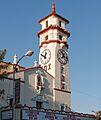
Historic buildings in Visalia include the Bank of Italy and the Visalia Town Center Post Office. Both are listed on the National Register of Historic Places. The Fox Theatre is another historic building. It is used for music and stage shows.
Sports in Visalia
Visalia is home to the Visalia Rawhide baseball team. They are a "single-A" team connected to the Arizona Diamondbacks. The Rawhide play in the California League at Recreation Park.
The city is also home to the Visalia Vapor Trailers. This is the longest-running official car club of the National Hot Rod Association (NHRA).

Education in Visalia
Colleges and Universities

College of the Sequoias is a community college located in Visalia. It is the only public college in the city.
Other universities have smaller campuses in Visalia:
- Fresno State
- Chapman University
- Fresno Pacific University
- Brandman University
Private colleges in Visalia include:
- San Joaquin Valley College
- University of Phoenix
Visalia is the only large city in the Central Valley with over 100,000 people that does not have its own four-year university.
Schools in Visalia
The Visalia Unified School District serves all of Visalia and some nearby communities. About 30,000 students attend schools in this district.
Media in Visalia
The main daily newspaper in Visalia is the Visalia Times-Delta.
Transportation in Visalia
Roads and Highways
California State Route 99 is a major highway that runs north and south. It connects Visalia to Fresno (north) and Bakersfield (south). California State Route 198 goes east to Sequoia National Park and west to San Lucas. California State Route 63 (Mooney Boulevard) goes north to Orosi and Kings Canyon National Park, and south to Tulare. California State Route 216 (Lovers Lane) goes east to Woodlake.

Public Transportation
Visalia Transit (formerly Visalia City Coach) provides bus services within Visalia and to nearby towns like Goshen, Farmersville, and Exeter. They also offer a Dial-A-Ride service for people who need door-to-door rides.
Tulare County Area Transit (TCaT) connects Visalia to smaller communities in the wider area. These services run Monday through Saturday.
Orange Belt Stages has a bus stop in Visalia for Amtrak train passengers. The Amtrak Thruway bus also connects Visalia to the nearest Amtrak station in Hanford.
The Sequoia Shuttle offers rides from Visalia and Three Rivers to Sequoia National Park.
The Loop is a free bus service for school-aged children. It helps them get to community and recreation centers in Visalia for activities.
In late 2015, the V-Line bus started running. This bus connects Visalia and Fresno. It stops at the Visalia Transit Center, Visalia Municipal Airport, Fresno Yosemite International Airport, Fresno State University, and the Fresno Courthouse. The bus ride costs $10 each way, with discounts for students, seniors, and disabled riders. The V-Line also has free WiFi and charging ports.
The California High-Speed Rail Authority plans to build a high-speed rail station about 20 miles west of Visalia. This station, called Kings–Tulare Regional Station, will serve both Hanford and Visalia.

Air Travel
The Visalia Municipal Airport is located in the city.
Train Transportation
Current Train Services

Visalia is currently served by the San Joaquin Valley Railroad. This line connects to the Union Pacific in Goshen, California. The railroad mainly serves the Visalia Industrial Park on the west side of the city.
Former Train Services
The Visalia Electric Railroad used to run east from the city. It had lines that went to Woodlake and Strathmore. This electric line operated from 1906 to 1990.
Visalia also used to have a station on the Atchison, Topeka and Santa Fe Railway line. This part of the rail line through Visalia was removed in 1994.
In 1887, the Visalia and Tulare railroad was created. It ran between Visalia and Tulare. This railroad stopped running by October 1900.

Sister Cities
Visalia has two sister cities:
 Putignano, Italy
 Miki, Japan
Images for kids
-
Visalia Transit Center
-
Visalia Fox Theatre
-
Visalia Bus Transit Center
-
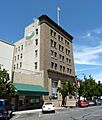
Bank of Italy Tower
-
Location within Tulare County
-

A view of East Visalia from Rocky Hill
See also
 In Spanish: Visalia (California) para niños
