
Geography of North Carolina facts for kids

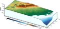
The geography of North Carolina is super interesting! This state has three main parts, each with its own special features. Imagine dividing North Carolina into three big slices:
- The Appalachian Mountains in the west, which include the famous Blue Ridge and Great Smoky Mountains.
- The central Piedmont area, which is like a plateau.
- The eastern Coastal Plain, which is flat and next to the ocean.
North Carolina is a pretty big state, covering about 53,821 square miles (139,391 km2). It stretches about 503 miles (810 km) long and 150 miles (241 km) wide. The land changes a lot from one side to the other. In the west, you'll find tall mountains like the Great Smoky Mountains, reaching almost 7,000 feet (2,134 m) high. But if you travel east, you'll reach the sandy beaches of the Atlantic Ocean, which are at sea level.
Contents
Mountains of North Carolina

North Carolina's western part is home to several mountain ranges. They are all part of the larger Appalachian Mountains system. Here are the main ones:
Great Smoky Mountains
These mountains are often called the "Smokies" because of the misty, blue haze that often covers them. They are a very famous and beautiful part of the state.
Blue Ridge Mountains
The Blue Ridge Mountains are North Carolina's largest mountain range. They have some of the highest peaks in the eastern United States. A part of the Blue Ridge is called the Black Mountains. Here, you'll find Mount Mitchell, which is the tallest mountain east of the Mississippi River. It stands at 6,684 feet (2,037.3 m) above sea level!
Brushy Mountains
The Brushy Mountains are a smaller and lower mountain range. They are found only within North Carolina.
Uwharrie Mountains
The Uwharrie Mountains are the easternmost mountain range in North Carolina. They are named after a Native American tribe that used to live in that area.
Piedmont Plateau
The Piedmont plateau makes up the middle section of North Carolina. This is where many of the state's biggest cities are located, like Charlotte and Raleigh. These cities are growing fast, with more people moving to new areas around them.
The land in the Piedmont is generally between 300 feet and 1,100 feet above sea level. There are a few small mountains, especially on the western side of this region. The Piedmont is also known for its many forests.
Historically, Tobacco has been a very important crop in the Piedmont. The first people to live in this area were the Catawba people. Europeans started to settle here in the 1700s.
Coastal Plain

The Coastal Plain is the largest part of North Carolina, covering about 45% of the state. It starts where the Piedmont Plateau ends, at a place called the fall line. Here, rivers often have waterfalls as the land drops. East of this line, the Coastal Plain is mostly flat. It has sandy soils that are great for growing crops like tobacco, cotton, soybeans, and melons. The rivers in this area are wider, deeper, and flow much slower than those in the Piedmont or mountains.
North Carolina doesn't have a very large natural harbor, so it never developed a major port city. A big part of its coastline is made up of the Outer Banks. These are sandy islands that are always changing their shape because they don't have coral reefs to hold them in place. The Outer Banks are sometimes called the "Graveyard of the Atlantic." This is because many ships have been wrecked there over the years due to strong storms and tides.
The Coastal Plain has three important capes: Cape Hatteras, Cape Lookout, and Cape Fear. The Cape Fear River often needs to be dredged (made deeper) so that large ships can travel on it.
Farming in North Carolina

Farming is a big part of North Carolina's economy. Different parts of the state grow different things.
Mountain Farming
In the mountain areas, farmers grow crops like sweet corn, wheat, oats, barley, hay, and tobacco. They also grow many different fruits and vegetables. More recently, growing Christmas Trees has become popular. Farmers in the mountains also raise Cattle and chickens to sell.
Piedmont and Coastal Plain Farming
The Piedmont region grows many of the same products as the mountains. Cotton is grown a lot in the southern half of the Piedmont. In the past, Longleaf pine forests were used to make products like tar, pitch, and turpentine. Now, these forests have mostly been replaced with loblolly pine trees. These trees are used to make paper pulp, plywood, and lumber.
North Carolina is also special because four types of grapes are native to the state. These are the Catawba, Isabella, Lincoln, and Scuppernong grapes.
River Systems


North Carolina has seventeen major river basins. A river basin is the area of land where all the water drains into a single river. These river systems can be grouped into three main types:
- Some rivers in the very western part of North Carolina flow northwest. These rivers eventually join the Mississippi River, which then flows into the Gulf of Mexico.
- In central North Carolina, rivers generally flow south towards South Carolina. From there, they eventually drain into the Altantic Ocean.
- Most rivers in eastern North Carolina flow east or southeast. They empty into one of the "sounds" that separate the mainland from the Outer Banks. A sound is a small body of water that connects to the ocean.
The line that separates rivers flowing to the Atlantic Ocean from those flowing to the Gulf of Mexico is called the Eastern Continental Divide. This important line runs along the Blue Ridge Mountains.
Lakes
North Carolina doesn't have many large natural lakes. However, you can find some oval-shaped lakes or ponds in the eastern part of the state, which are called Carolina bays.
The state does have many large reservoirs. These are artificial lakes built along major river systems. Many reservoirs provide drinking water for cities. They are also popular places for fun activities like boat ramps, fishing, and swimming at beaches.
Climate
North Carolina's climate is generally humid, warm, and stable. This is because of its location in the middle of the Northern Hemisphere. Most of the state is east of the Appalachian Mountains, which act like a shield. They protect the state from cold winter winds coming from the northwest. Also, the warm Gulf Stream ocean current near the coast helps keep the ocean side warmer during winter.
| Cities | Jan | Feb | Mar | Apr | May | Jun | Jul | Aug | Sep | Oct | Nov | Dec |
|---|---|---|---|---|---|---|---|---|---|---|---|---|
| Asheville | 46/26 | 50/28 | 58/35 | 66/42 | 74/51 | 80/58 | 83/63 | 82/62 | 76/55 | 67/43 | 57/35 | 49/29 |
| Cape Hatteras | 54/39 | 55/39 | 60/44 | 68/52 | 75/60 | 82/68 | 85/73 | 85/72 | 81/68 | 73/59 | 65/50 | 57/43 |
| Charlotte | 51/32 | 56/34 | 64/42 | 73/49 | 80/58 | 87/66 | 90/71 | 88/69 | 82/63 | 73/51 | 63/42 | 54/35 |
| Greensboro | 47/28 | 52/31 | 60/38 | 70/46 | 77/55 | 84/64 | 88/68 | 86/67 | 79/60 | 70/48 | 60/39 | 51/31 |
| Raleigh | 50/30 | 54/32 | 62/39 | 72/46 | 79/55 | 86/64 | 89/68 | 87/67 | 81/61 | 72/48 | 62/40 | 53/33 |
| Wilmington | 56/36 | 60/38 | 66/44 | 74/51 | 81/60 | 86/68 | 90/72 | 88/71 | 84/66 | 76/54 | 68/45 | 60/38 |
Fun Facts About North Carolina's Geography
- Fog is common, especially during the summer months.
- Frost usually doesn't appear until mid-October along the coast.
- Ice forms on surfaces at least once every winter near the ocean, and much more often in the mountains.
- Snowfall is usually light and doesn't stay on the ground for long, except in higher elevations.
- North Carolina gets about 5 inches (130 mm) of snow each winter season on average.
- The average rainfall is about fifty-three inches per year.
- North Carolina is the 14th wettest state in the United States when it comes to precipitation (rain and snow).
- The hottest temperature ever recorded in North Carolina was 110 °F (43.3 °C) on August 21st, 1983.
- The coldest temperature ever recorded was -34 °F (-36.7 °C) on January 21st, 1985.
- Average temperatures in the summer are around 80 °F (27 °C).
- Average temperatures in the winter are around 50 °F (10 °C).
Images for kids
-
3D Topographical Map of North Carolina

