
Great Flood of 1913 facts for kids

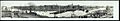
Main Street in Dayton, Ohio, during the flood
|
|
| Date | March 23–26, 1913 |
|---|---|
| Location | Alabama, Arkansas, Connecticut, Illinois, Indiana, Kentucky, Louisiana, Maryland, Massachusetts, Mississippi, Missouri, New Hampshire, New Jersey, New York, North Carolina, Ohio, Pennsylvania, Tennessee, Vermont, and Virginia |
| Deaths | est. 650 |
| Property damage | $333,000,000 |
The Great Flood of 1913 was a huge natural disaster that happened between March 23 and March 26, 1913. Major rivers in the central and eastern United States overflowed their banks. This happened after several days of very heavy rain.
The flood caused widespread damage and many deaths across the country. About 650 people died in Ohio, Indiana, and eleven other states. Ohio had between 422 and 470 deaths. Indiana had an estimated 100 to 200 deaths. More than 250,000 people lost their homes. This flood was one of the deadliest in U.S. history, second only to the Johnstown Flood of 1889. It remains Ohio's biggest weather disaster ever.
The flood caused over $333 million in damages across the Midwest. Dayton, Ohio, alone suffered over $73 million in damage. Indiana had about $25 million in damages. Further south, along the Mississippi River, damages were over $200 million. This huge flood, and others that followed, changed how the U.S. manages its rivers. It led to more federal support for flood prevention. For example, Ohio passed the Ohio Conservancy Act in 1914. This law allowed areas to create special districts to build flood control projects.
Contents
How the Flood Started
The storm system that caused the flood began like a normal winter storm. But it quickly became much stronger. Strong winds from Canada trapped a high-pressure system near Bermuda. This stopped the usual movement of a low-pressure system. At the same time, moist air from the Gulf of Mexico moved into the Midwest. This air traveled through the Mississippi River valley.
Another high-pressure system from Canada arrived from the west. This created a long area of low pressure stretching from southern Illinois, across central Indiana, and into northern Ohio. At least two low-pressure systems moved along this path. They caused very heavy rain for four days, from March 23 to March 26.
The Storm's Path
On Sunday, March 23, the storm grew stronger. High winds, hail, sleet, and tornadoes hit the Great Plains, the Southern, and Midwestern United States. Big tornadoes struck Omaha, Nebraska; Lone Peach, Arkansas; and Terre Haute, Indiana.
On Monday and Tuesday, March 24 and 25, between 3 and 8 inches of rain fell in Ohio, Indiana, and southern Illinois. Major rivers in Indiana and Ohio quickly filled up. Downstream, where the Ohio River meets the Mississippi River, water levels broke all previous records.
By Tuesday, March 25, the Ohio River and its smaller rivers flooded many cities. These included Indianapolis, Indiana, Cincinnati, Youngstown, and Columbus, Ohio. Dayton, Ohio, was hit especially hard. On Wednesday, March 26, the storm moved east into Pennsylvania and New York. Heavy rain continued in the Ohio River valley. The heaviest rain, 6 to 9 inches or more, covered an area from southern Illinois to northwestern Pennsylvania. As the storm moved east, flooding also began in New York, Massachusetts, Vermont, and Virginia. The Potomac River overflowed its banks in Maryland.
Areas Hit by the Flood
The storms that caused the 1913 floods lasted for several days. They produced record-breaking amounts of rain. This event is still Ohio's "largest weather disaster." It also caused Indiana's worst flood ever recorded.
More than a dozen states were affected by the storm-related flooding. These included Alabama, Arkansas, Connecticut, Illinois, Indiana, Kentucky, Louisiana, Maryland, Massachusetts, Mississippi, Missouri, New Hampshire, New Jersey, New York, North Carolina, Ohio, Pennsylvania, Tennessee, Vermont, and Virginia. The same weather system also caused major tornadoes. These tornadoes hit the Great Plains, the South, and the Midwest. The most notable ones were in Omaha, Nebraska; Lone Peach, Arkansas; and Terre Haute, Indiana.

Dayton, Ohio Flooding

.jpg)
Between March 23 and 25, heavy rains and rising waters hit Dayton. The Great Miami River burst its levees (protective walls) on Dayton's south side. This flooded 14 square miles of the city. Water was 10 feet deep in downtown Dayton streets. On March 26, as the floodwaters reached their highest point, Dayton's business area suffered more damage. An early morning fire and gas explosion made things worse. About 123 people died in Dayton. Downstream in nearby Hamilton, Ohio, about 100 people died. Water was 10 to 18 feet deep in its neighborhoods.
Columbus, Ohio Flooding
In Columbus, the Near West Side and parts of downtown were severely flooded. About 93 people died in the flooding. A historian named Ed Lentz called it "the worst catastrophe in the history of Columbus."
Indianapolis, Indiana Flooding

About 6 inches of rain fell on Indianapolis from March 23 to March 26. This flooded nearly a 6-square-mile area. Five known deaths occurred. On March 26, floodwaters were 19.5 feet above flood stage. They destroyed Indianapolis's Washington Street bridge. This was the main connection over the White River. High water forced 4,000 people to leave their homes. This happened when an earthen levee broke. A 25-foot wall of water flooded an area almost half a mile wide. The city's transportation and water supply were cut off for nearly four days. As many as 7,000 Indianapolis families lost their homes.
Factors That Caused the Flood
Several things contributed to the widespread flooding.
Weather Conditions
The weather pattern that caused the heavy rains in the Midwest started when strong Canadian winds stopped a high-pressure system near Bermuda. This prevented a low-pressure system from moving east as it normally would. Meanwhile, moist air from the Gulf of Mexico moved into the Midwest through the Mississippi River valley. A second Canadian high-pressure system arrived from the west. This squeezed the low-pressure system into a trough (a long, narrow area of low pressure). This trough stretched from southern Illinois, across central Indiana, and into northern Ohio.
At least two low-pressure systems moved quickly along this trough. They dumped one rainstorm after another. The weather pattern stayed almost the same for four days, from March 23 to March 26. This caused very heavy rain over the Ohio River valley. The heaviest rainfall, 6 to 9 inches or more, covered an area from southern Illinois to northwestern Pennsylvania. Louisville, Kentucky, had the heaviest recorded rainfall rate. It received 1.05 inches in just twenty-eight minutes on March 25.
Other factors that made the flooding worse were the storm's size, how long it lasted, and the ground conditions. Rivers and streams were at normal or even low levels just two days before the major flooding in Indiana and Ohio. Some experts believe the ground quickly became soaked. This led to water running off the surface and causing flash floods. Others think that frozen ground in smaller river areas also added to the flooding along the main rivers. Up to 8 inches of snow fell after the heavy rain in northern Indiana. In some places, thawed ground and no snow on the ground might have helped reduce the damage from runoff and flooding.
River Basins
Rivers rose many feet above their previous high-water marks in Ohio and Indiana. This happened after heavy rains fell at the start of the region's rivers. The rivers in the area experienced a lot of runoff. This was especially true along the Muskingum, Scioto, Great Miami, and Wabash rivers.
The Scioto River basin in central Ohio recorded a flood level of 21 feet. This is still a record, almost 4 feet higher than its other recorded floods. The Great Miami River and its smaller rivers, including the Whitewater River in Indiana, rose at least 10 feet higher than previous flood levels in many places. Downstream from Indiana and Ohio, where the Ohio River enters the Mississippi River at Cairo, Illinois, the water level reached 54.7 feet. This broke all records up to that time. High waters continued to flow south to the Gulf of Mexico. This caused some levees to break in Arkansas, Kentucky, Louisiana, Mississippi, and Missouri. Water from the flooded rivers flowing into the Mississippi River in April set new height records further downriver. This made cities like Memphis, Tennessee; Natchez, Mississippi; and New Orleans, Louisiana prepare for flooding.
Timeline of Events
The storm system that caused the flood in late March started like a typical winter storm. But it quickly developed special features that led to very heavy rain.
Friday, March 21
- A series of nine tornadoes hit the Gulf States of Alabama, Georgia, and Mississippi. They destroyed towns, killed 48 people, and injured 150.
- A blizzard (heavy snowstorm) hit twenty states and killed 21 people.
- Temperatures dropped below freezing in the Midwest. Hurricane-force winds moved into Ontario, Canada. Record-setting winds reached 60 mph in Indianapolis, Indiana; 66 mph in Louisville, Kentucky; 84 mph in Toledo, Ohio; 86 mph in Detroit, Michigan; and 90 mph in Buffalo, New York.
Sunday, March 23
- The storm gained strength. High winds and sleet in the Midwest knocked down buildings, telephone poles, and power lines. This cut off electricity and made communication very difficult.
- The storm prevented the U.S. Weather Bureau from getting and sharing weather warnings in time.
- A high-pressure system moved northeast over New England. A low-pressure system was over Colorado. Strong southerly winds increased between the two systems. Warm, moist air entered the Great Plains and the Ohio River valley.
- Gusty winds caused a dust storm in Kansas. Missouri was hit with hail and heavy rain. A series of funnel clouds moved across Nebraska, Iowa, Illinois, Missouri, Michigan, and Indiana. At least six tornadoes struck the Midwest, killing about 221 people and injuring 761.
- Major tornadoes hit Omaha, Nebraska. A tornado also hit Terre Haute, Indiana, that same evening.
Monday, March 24
- The first low-pressure system from the storm weakened. It moved northeast from the Great Lakes into eastern Canada and New England.
- The system stalled over the Ohio River basin, causing more rain and thunderstorms.
- A second low-pressure system developed in Colorado. It merged with a third low that formed over western Texas.
- Rainfall totals from Sunday through Monday, March 23 and 24, measured 3 to 8 inches in Ohio, Indiana, and southern Illinois. This was more than the normal monthly rainfall in less than two days. Rain continued, averaging 3 to 6 inches in southern Indiana and western Ohio.
- Flooding moved into central Indiana. Water levels were at or near their highest points along the Wabash River, the White River near Indianapolis, and the East Fork of the White River. Eastern Indiana flooded after the Maumee, Whitewater, and upper parts of the Wabash and White Rivers reached record high levels.
- Heavy rain fell at Dayton. The Great Miami River reached a high level and continued to rise.
Tuesday, March 25
- The Ohio River and its smaller rivers flooded cities like Indianapolis, Indiana, Cincinnati, Columbus, Ohio, and Fort Wayne, Indiana.
- Rising water overflowed and then broke levees in Dayton. This flooded its downtown business area. Water levels continued to rise.
Wednesday, March 26
- The center of the low-pressure system moved east over New York. Rain continued in the Ohio River valley.
- Floodwaters reached their highest point in Dayton. Its downtown business area suffered more damage from fires and a gas explosion.
Thursday, March 27
- Flooding in south-central and southwest Indiana damaged or destroyed areas near Bedford, Shoals, Terre Haute, Vincennes, and Washington. This happened after the Wabash, White, and East Fork of the White Rivers reached their highest points.
- Rainfall measured 2 to 5 inches over Kentucky and Tennessee.
- The storm trough moved eastward into Pennsylvania and New York. This slowly ended the heavy rain over the Ohio River valley. In some areas, snow replaced the rain. Up to 8 inches of snow fell in central and northern Indiana.
- Ohio governor James M. Cox created a Dayton Relief Commission.
Friday, March 28
- A cold system brought frost to the Gulf States. Heavy rains over the northeast caused flooding in New York, Massachusetts, Vermont, and Virginia.
- The Potomac River overflowed its banks in Maryland. It reached a high of 18 feet and flooded Hagerstown. Other communities like Cumberland, Maryland, also felt the effects of the floods. They caused damage but no deaths.
Relief Efforts After the Flood
Right after the floods, businesses and factories closed. Schools shut down, and government services were disrupted. Train travel was delayed or stopped across the Midwest. Many newspapers could not be published during the storm. Within weeks, theaters across the country were showing pictures of the flood damage in Dayton and other Ohio cities. They also showed tornado damage in Omaha, Nebraska.
In 1913, the federal government did not provide much disaster relief. So, state and local communities handled most of their own disaster response and help. Cleanup efforts were very difficult. There were increased risks of fire and health problems. Communication systems were damaged, and transportation networks were broken. Streets were full of debris, and utility systems were flooded.
The American Red Cross was a small organization in March 1913. It had only a few full-time employees and about sixty volunteer chapters. President Woodrow Wilson named it "the official disaster-relief agency for the federal government." Newspapers across the country asked people to donate to the Red Cross to help flood victims.
President Wilson also sent messages to the governors of Ohio and Indiana. He asked how the federal government could help. Indiana governor Samuel M. Ralston did not get President Wilson's message because of damaged communication lines. Ohio governor James M. Cox asked the president for tents, food, supplies, and doctors. He also asked the Red Cross for help in Dayton and nearby communities. Red Cross agents and nurses focused their efforts in 112 of Ohio's hardest-hit communities. These were mainly along Ohio's major rivers. The Red Cross had less presence in Indiana. There, it set up a temporary office in Indianapolis and helped the six hardest-hit counties.
Governor Cox asked the Ohio legislature to set aside $250,000 for emergency aid. He also declared a 10-day bank holiday. Cox, who also owned the Dayton Daily News, gave daily updates to the press. He also asked for donations. Governor Ralston asked Indiana cities and other states for help and donations. He appointed someone to receive relief funds and arrange for supplies to be given out. About half of Indiana's counties took care of their own flood victims. Railroads, like the "Big Four, the Pennsylvania Lines, and the Vandalia," offered their equipment to the Indiana governor. They also had work crews rebuild the state's rail network.
Many organizations contributed funds for flood relief. The Chicago Association of Commerce sent $100,000 to the Red Cross on March 26. Rotary clubs across the United States gave over $25,000 to a Rotary Relief Fund. This fund was set up for flood relief in Indiana and Ohio. It was the organization's "first cooperative disaster relief effort." In some areas, local groups helped with relief efforts. The Rotary Club of Indianapolis and the Rotary Club of Dayton helped provide medical support, transportation, and shelter. Other Rotary clubs in the U.S. and Canada donated funds, supplies, and medicine. In Colorado, actress Sarah Bernhardt and actor John Drew, Jr. gave a special performance. This raised $5,000 for a $41,000 relief fund already collected by Colorado residents for flood victims.
Deaths from the Flood
The exact number of deaths from the flood may never be known. One estimate of storm-related deaths from March 21 to March 28 is more than 900. Flood deaths in Ohio, Indiana, and eleven other states are estimated at about 650. This makes the 1913 flood the second deadliest in the country. The Johnstown Flood of 1889 killed more than 2,200 people.
Official reports of flood deaths are not always consistent. Some victims' bodies were never found. Not all deaths were reported to agencies collecting flood information. Some deaths from injuries or illness after the flood were not counted in official reports. About 467 flood deaths have been reported for Ohio. The official death toll range is between 422 and 470. Dayton's official death toll was not certain. Ohio's Bureau of Statistics listed 82 people, while one flood historian says 98. Others reported Dayton's death toll at nearly 300. This figure might have included other neighborhoods and cities. Estimated deaths for flood victims in Indiana are 100 to 200. Flooding in the Great Miami River basin caused at least 260 deaths. This was more than in any other river basin. About 17 people died in flooding in the Whitewater River basin.
Health Issues After the Flood
After the flood, there were outbreaks of diseases like diphtheria and typhus in some flooded areas. One such area was north-central Dayton, Ohio. It is thought that about 2,000 more people had to go to the hospital because of these outbreaks. This was in addition to the direct damage from the flood itself. While information for Indiana is not fully available, it's estimated that another 1,000 people in that state were affected by these health issues.
Estimated Damages

The damage from the flood was widespread and very extensive. The storm destroyed hundreds of bridges and railroad tracks. It also took down 12,000 telegraph and telephone poles. Flooding stopped communications between Chicago and New York for a day and a half. It also disrupted road and rail transportation and slowed mail delivery. More than 38,000 homes and other buildings were damaged or destroyed. Thousands of schools, businesses, and city streets were also affected. Over 250,000 people were left without homes.
In the Midwest alone, damage estimates were over "a third of a billion dollars." One flood historian suggests these numbers were actually lower than the real cost. The Dayton Citizens' Relief Committee reported over $73 million in damage in Dayton. Damage in Indiana was estimated at $25 million in 1913 dollars. Cairo, Illinois, knew high water was coming a week after the Dayton flood. So, it reported no deaths. But damage estimates there and in smaller communities like Shawneetown, Illinois, were over $5 million. Along the Mississippi River, damages were over $200 million.
Long-Term Impact of the Flood
The huge damage from the 1913 flood, and later floods along the Mississippi River in 1917, 1927, 1936, and 1937, changed how the country managed its waterways. It led to more support from Congress for national flood control measures. This went beyond just emergency help.
New Laws for Flood Control
After the 1913 flood, people and government officials became more interested in preventing floods. They wanted to manage flood-prone areas and fund projects to control floods. These projects would limit damage and save lives. Before this, Congress thought floods were local problems. They believed flood control was up to state and local governments.
The Flood Control Act of 1917 was the first of several laws. These laws eventually led to the creation of the National Flood Insurance Program in 1968. They also led to the Federal Emergency Management Agency (FEMA) in 1979, and the Robert T. Stafford Disaster Relief and Emergency Assistance Act of 1988. Federal funding for national flood control projects started slowly in 1917. Congress approved money for flood control studies in the Mississippi River. By 1925, this funding was expanded to include other major rivers in the United States.
State and Local Flood Programs
The Dayton Relief Committee started soon after the 1913 flood. It aimed to raise $2 million to create a full flood protection system. This system would prevent another disaster of the same size. The committee hired Arthur Ernest Morgan and his Morgan Engineering Company. They designed a plan that used levees and dams.
On March 17, 1914, the governor of Ohio signed the Ohio Conservancy Act. This law allowed areas to create special "conservancy districts." These districts had the power to carry out flood control projects. Ohio's Upper Scioto Conservancy District was the first to form in February 1915. The Miami Conservancy District (MCD), which includes Dayton and nearby communities, was the second. It formed in June 1915. The MCD began building its flood control system in 1918. The project was finished in 1922. It cost over $32 million. This system has prevented Dayton from flooding as severely as it did in 1913. The Ohio Conservancy Act became a model for other states, such as Indiana, New Mexico, and Colorado.
Images for kids
-
Flooding in Delaware, Ohio on March 29, 1913
