
List of bridges on the National Register of Historic Places in Texas facts for kids
Did you know that many old and important bridges in Texas are special? They are listed on something called the National Register of Historic Places. This is like a hall of fame for buildings, places, and objects that are important to American history. When a bridge is on this list, it means it's worth protecting and remembering because of its history or how it was built.
Texas has many such bridges. They show us how people traveled and built things long ago. Let's explore some of these amazing historic bridges!
Contents
- Historic Bridges Across Texas
- Bridges in Houston and Surrounding Areas
- Almeda Road Bridge over Brays Bayou
- Hill Street Bridge over Buffalo Bayou
- McKee Street Bridge
- Sabine Street Bridge over Buffalo Bayou
- San Jacinto Street Bridge over Buffalo Bayou
- State Highway 35 Bridge at the West Fork of the San Jacinto River
- Telephone Road Bridge over Brays Bayou
- Washburn Tunnel
- Yale Street Bridge over White Oak Bayou
- Bridges in Central Texas
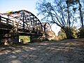
- Brazoria Bridge
- Bunton Branch Bridge
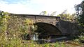
- Colorado River Bridge at Bastrop
- Faust Street Bridge
- Iron Bridge (Bastrop, Texas)
- Lamar Boulevard Bridge
- Montopolis Bridge
- Moore's Crossing Bridge
- Mueller Bridge
- Nolan River Bridge 303-A of the Gulf, Colorado and Santa Fe Railway
- Paddock Viaduct
- Regency Suspension Bridge
- Riverside Swinging Bridge
- State Highway 19 Bridge at Trinity River
- State Highway 27 Bridge at Johnson Fork
- State Highway 27 Bridge at the Guadalupe River
- State Highway 27 Bridge at the South Llano River
- State Highway 29 Bridge at the Colorado River
- State Highway 3 Bridge at the Colorado River
- State Highway 3 Bridge at the Nueces River
- State Highway 3 Bridge at the Trinity River
- State Highway 3-A Bridge at Cibolo Creek
- State Highway 3-A Bridge at Plum Creek
- State Highway 53 Bridge at the Leon River
- State Highway 71 Bridge at the Colorado River
- State Highway 89 Bridge at the Brazos River
- State Highway 9 Bridge at the Llano River
- Third Street Railroad Trestle
- US 190 Bridge at the Colorado River
- US 281 Bridge at the Brazos River
- Waco Suspension Bridge
- Washington Avenue Bridge (Waco, Texas)
- West Fifth Street Bridge at Shoal Creek
- West Sixth Street Bridge at Shoal Creek
- Bridges in East Texas
- Bridges in West Texas and the Panhandle
- Beaver Creek Bridge
- Bedstead Truss Bridge
- Bluff Dale Suspension Bridge
- Colorado River Bridge (Wharton, Texas)
- Cummins Creek Bridge
- East Navidad River Bridge
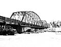
- Fort Griffin Brazos River Bridge
- Gregory Road Bridge at Duck Creek
- Hubbard Creek Bridge
- Kansas City, Mexico and Orient Railway and Gulf, Colorado and Santa Fe Railway Overpass
- Lone Wolf Crossing Bridge
- Medio Creek Bridge
- Mulberry Creek Bridge
- Rector Road Bridge at Clear Creek
- Roma-San Pedro International Bridge
- Route 66 Bridge over the Chicago, Rock Island and Gulf Railroad
- State Highway 16 Bridge at the Brazos River
- State Highway 23 Bridge at the Clear Fork of the Brazos River
- State Highway 34 Bridge at the Trinity River
- State Highway 5 Bridge at High Creek
- State Highway 78 Bridge at the Red River
- State Highway 79 Bridge at the Red River
- State Highway Bridge 5 at Big Pine Creek
- Texas and New Orleans Railroad Bridge
- US 83 Bridge at the Salt Fork of the Red River
- Other Notable Bridges
- Bridges in Houston and Surrounding Areas
- Images for kids
Historic Bridges Across Texas
Texas is a big state with many rivers and bayous. Because of this, bridges have always been super important for people to travel and move goods. The bridges on this list are not just old; they are special because of their unique designs, their age, or the role they played in local history.
Bridges in Houston and Surrounding Areas
Houston, a large city in Texas, has several historic bridges. These bridges helped the city grow by connecting different areas.
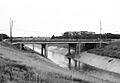
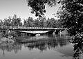
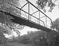
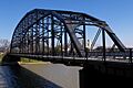
Almeda Road Bridge over Brays Bayou
- Built: 1931
- Location: Houston
- Type: This bridge is a continuous span concrete beam bridge. This means it's made of strong concrete beams that stretch across the water.
- What makes it special: It's a great example of how bridges were built in the early 20th century to handle more traffic as cities grew.
Hill Street Bridge over Buffalo Bayou
- Built: 1938
- Location: Houston
- Type: A steel beam bridge.
- What makes it special: This bridge is a good example of how steel was used to create strong and lasting bridges.
McKee Street Bridge
- Built: 1932
- Location: Houston
- Type: A continuous span concrete beam bridge.
- What makes it special: Like the Almeda Road Bridge, this one shows the popular concrete beam design used in the 1930s.
Sabine Street Bridge over Buffalo Bayou
- Built: 1924
- Location: Houston
- Type: A concrete span bridge.
- What makes it special: This bridge is an early example of concrete construction in Houston.
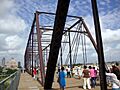
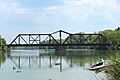
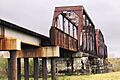
San Jacinto Street Bridge over Buffalo Bayou
- Built: 1914
- Location: Houston
- Type: A concrete arch bridge.
- What makes it special: Arch bridges are known for their strength and beauty, and this one is a fine example from the early 1900s.
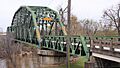
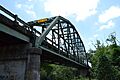
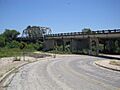
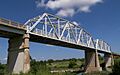
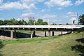
State Highway 35 Bridge at the West Fork of the San Jacinto River
- Built: 1930-1931
- Location: Humble
- Type: A Parker through truss bridge.
- What makes it special: Truss bridges use a framework of triangles to support the weight, making them very strong.
Telephone Road Bridge over Brays Bayou
- Built: 1931
- Location: Houston
- Type: A continuous span concrete bridge.
- What makes it special: This bridge is another example of the common concrete designs used in the Houston area during the 1930s.
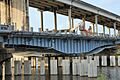
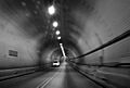
Washburn Tunnel
- Built: 1947
- Location: Houston
- Type: A subaqueous tunnel.
- What makes it special: While not a bridge, this tunnel is also listed as a historic structure because it goes under the water, which was a big engineering feat!
Yale Street Bridge over White Oak Bayou
- Built: 1931
- Location: Houston
- What makes it special: This bridge is part of Houston's historic transportation network.
Bridges in Central Texas
Central Texas, including cities like Austin and Waco, also has many old bridges that are important to history.
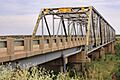
Brazoria Bridge
- Built: 1939
- Location: Brazoria
- Type: A Parker through truss bridge.
- What makes it special: This bridge is a good example of the Parker truss design, which was popular for its strength.
Bunton Branch Bridge
- Built: 1915, 1917, 1932
- Location: Kyle
- Type: A concrete arch bridge.
- What makes it special: Arch bridges are known for their classic look and durability.
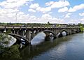
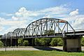
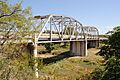
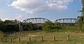
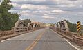
Colorado River Bridge at Bastrop
- Built: 1923
- Location: Bastrop
- Type: A Parker through truss bridge.
- What makes it special: This bridge helped connect communities across the Colorado River.
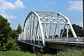
Faust Street Bridge
- Built: 1887
- Location: New Braunfels
- What makes it special: This is a very old bridge, showing how people built crossings over a century ago.
Iron Bridge (Bastrop, Texas)
- Built: 1883
- Location: Bastrop
- Type: A truss type bridge.
- What makes it special: One of the oldest bridges on the list, it's a testament to early bridge building in Texas.
Lamar Boulevard Bridge
- Built: 1941-1942
- Location: Austin
- Type: A continuous span concrete arch bridge.
- What makes it special: This bridge is a key part of Austin's history and transportation.
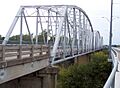
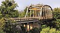
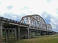
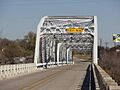
Montopolis Bridge
- Built: 1937-1938
- Location: Austin
- Type: A Parker through truss bridge.
- What makes it special: This bridge is a well-known landmark in Austin.
Moore's Crossing Bridge
- Built: 1922
- Location: Austin
- Type: A Parker through truss bridge.
- What makes it special: It's part of a larger historic district, showing how important it was to the area.
Mueller Bridge
- Built: 1915
- Location: La Vernia
- Type: A Warren polygonal chord truss.
- What makes it special: This type of truss bridge uses a unique zigzag pattern for strength.
Nolan River Bridge 303-A of the Gulf, Colorado and Santa Fe Railway
- Built: 1903
- Location: Cty. Rd. 1127 at Nolan R.
- What makes it special: This railway bridge is an important piece of railroad history.
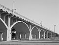
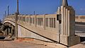
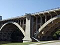
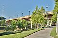
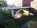
Paddock Viaduct
- Built: 1912-1914
- Location: Fort Worth
- Type: A continuous span concrete arch.
- What makes it special: Viaducts are long bridges that carry roads or railways over valleys or other obstacles.
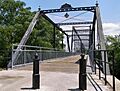
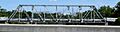
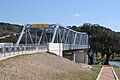
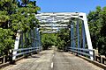
Regency Suspension Bridge
- Built: 1939
- Location: Regency
- Type: A suspension bridge.
- What makes it special: Suspension bridges are famous for their long main spans, held up by cables. This one is a beautiful example.
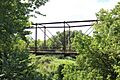
Riverside Swinging Bridge
- Built: 1904
- Location: Riverside
- Type: A Pratt through truss.
- What makes it special: This bridge is known for its "swinging" motion, which makes it unique!
State Highway 19 Bridge at Trinity River
- Built: 1940
- Location: Riverside
- Type: A Parker through truss.
- What makes it special: This bridge is another example of the strong Parker truss design.
State Highway 27 Bridge at Johnson Fork
- Built: 1937-1938
- Location: Junction
- Type: A Parker through truss.
State Highway 27 Bridge at the Guadalupe River
- Built: 1937-1938
- Location: Cuero
- Type: A Parker through truss.
State Highway 27 Bridge at the South Llano River
- Built: 1936-1937
- Location: Junction
- Type: A Warren through truss.
State Highway 29 Bridge at the Colorado River
- Built: 1937
- Location: Buchanan Dam
- Type: A Parker through truss.
State Highway 3 Bridge at the Colorado River
- Built: 1931-1932
- Location: Columbus
- Type: A Parker through truss.
State Highway 3 Bridge at the Nueces River
- Built: 1932, 1933, 1935
- Location: Uvalde
- Type: A Parker through truss.
State Highway 3 Bridge at the Trinity River
- Built: 1929-1930
- Location: Liberty
- Type: A Parker through truss.
State Highway 3-A Bridge at Cibolo Creek
- Built: 1932-1933
- Location: Schertz
- Type: A Parker through truss.
State Highway 3-A Bridge at Plum Creek
- Built: 1930-1931
- Location: Luling
- Type: A Parker through truss.
State Highway 53 Bridge at the Leon River
- Built: 1938-1939
- Location: Belton
- Type: A Parker through truss.
State Highway 71 Bridge at the Colorado River
- Built: 1940-1941
- Location: La Grange
- Type: A Parker through truss.
State Highway 89 Bridge at the Brazos River
- Built: 1933-1934
- Location: Millsap
- Type: A Parker through truss.
State Highway 9 Bridge at the Llano River
- Built: 1936
- Location: Mason
- Type: A Warren polygonal chord truss.
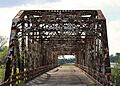
Third Street Railroad Trestle
- Built: Around 1922
- Location: Austin
- Type: A trestle bridge.
- What makes it special: Trestle bridges use a series of short spans supported by frames, often used for railroads.
US 190 Bridge at the Colorado River
- Built: 1939-1940
- Location: Lometa
- Type: A Warren polygonal chord truss.
US 281 Bridge at the Brazos River
- Built: 1938-1939
- Location: Santo
- Type: A Warren polygonal chord truss.
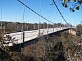
Waco Suspension Bridge
- Built: 1870
- Location: Waco
- Type: A suspension bridge.
- What makes it special: This is one of the oldest and most famous suspension bridges in Texas, a true landmark!
Washington Avenue Bridge (Waco, Texas)
- Built: 1902
- Location: Waco
- Type: A Pennsylvania through truss.
West Fifth Street Bridge at Shoal Creek
- Built: 1931
- Location: Austin
- Type: A cantilever girder.
West Sixth Street Bridge at Shoal Creek
- Built: 1887
- Location: Austin
- Type: A masonry arch.
- What makes it special: This bridge is a beautiful example of older construction using stone or brick arches.
Bridges in East Texas
East Texas is home to bridges that cross major rivers and connect Texas with neighboring states.
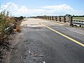
Angelina River Bridge
- Built: 1935
- Location: Lufkin
- Type: A span concrete beam.
- What makes it special: This bridge was unfortunately demolished around 1998, but it was once a historic crossing.
Burr's Ferry Bridge
- Built: 1936-1937
- Location: Burkeville
- Type: A Parker through truss.
- What makes it special: This bridge connects Texas and Louisiana across the Sabine River.
Cow Bayou Swing Bridge
- Built: 1940
- Location: Bridge City
- What makes it special: Swing bridges can rotate to allow boats to pass through, which is a cool feature!
Deweyville Swing Bridge
- Built: 1936
- Location: Deweyville
- What makes it special: Another swing bridge, important for both road and river traffic.
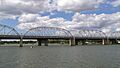
Port Arthur-Orange Bridge
- Built: 1936-1938
- Location: Groves
- Type: A cantilever through truss.
- What makes it special: Cantilever bridges are built using structures that project horizontally into space, supported only at one end.
US 190 Bridge at the Neches River
- Built: 1941-1943
- Location: Jasper
- Type: A Parker through truss.
Bridges in West Texas and the Panhandle
The western parts of Texas also have important historic bridges, often crossing wide rivers or canyons.
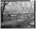
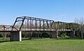
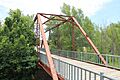
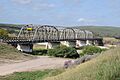
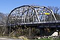
Beaver Creek Bridge
- Built: 1925
- Location: Electra
- Type: A Warren pony truss.
- What makes it special: Pony truss bridges have their trusses on the sides, but they don't connect overhead.
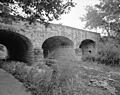
Bedstead Truss Bridge
- Built:
- Location: Schulenburg
- What makes it special: This bridge has a unique "bedstead" design.
Bluff Dale Suspension Bridge
- Built: Around 1895, with changes in 1925 and 1934
- Location: Bluff Dale
- Type: A Cable-stayed bridge.
- What makes it special: Cable-stayed bridges use cables directly connected to the towers to support the bridge deck.
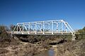
Colorado River Bridge (Wharton, Texas)
- Built: 1930
- Location: Wharton
- Type: A Parker through truss.
Cummins Creek Bridge
- Built: 1890
- Location: Round Top
- Type: A Pratt through truss.
- What makes it special: The Pratt truss is a very common and effective truss design.
- Built: 1923
- Location: Schulenburg
- What makes it special: This bridge is part of the historic crossings in the Schulenburg area.
Fort Griffin Brazos River Bridge
- Built: 1885
- Location: Fort Griffin
- Type: A Pratt through truss.
- What makes it special: This old iron bridge is a great example of 19th-century engineering.
Gregory Road Bridge at Duck Creek
- Built: 1923
- Location: Sanger
- Type: A Warren pony truss.
Hubbard Creek Bridge
- Built: 1928-1929
- Location: Albany
- Type: A Pratt through truss.
Kansas City, Mexico and Orient Railway and Gulf, Colorado and Santa Fe Railway Overpass
- Built: 1935
- Location: Sweetwater
- Type: A concrete arched-girder.
- What makes it special: This overpass is part of a historic commercial district.
Lone Wolf Crossing Bridge
- Built: 1922
- Location: San Angelo
- Type: A Pratt through truss.
Medio Creek Bridge
- Built: 1897, with changes in 1923
- Location: Normanna
- Type: A Pratt through truss.
Mulberry Creek Bridge
- Built: 1888
- Location: Schulenburg
- Type: A Pratt pony truss.
- What makes it special: This bridge was removed from the National Register in 2013, but it was once considered historic.
Rector Road Bridge at Clear Creek
- Built: 1907-1908
- Location: Sanger
- Type: A Pratt through truss.
- What makes it special: This bridge was moved to a new location to preserve it.
Roma-San Pedro International Bridge
- Built: 1927-1928
- Location: Roma-Los Saenz
- Type: A suspension bridge.
- What makes it special: This bridge connects the United States with Mexico, making it an international landmark!
Route 66 Bridge over the Chicago, Rock Island and Gulf Railroad
- Built: 1932
- Location: Shamrock
- What makes it special: This bridge is part of the famous historic Route 66, a legendary highway across America.
State Highway 16 Bridge at the Brazos River
- Built: 1938-1939
- Location: Benjamin
- Type: A Warren through truss.
State Highway 23 Bridge at the Clear Fork of the Brazos River
- Built: 1929
- Location: Albany
- Type: A Parker through truss.
State Highway 34 Bridge at the Trinity River
- Built: 1933-1934
- Location: Rosser
- Type: A Parker through truss.
- What makes it special: This bridge was demolished around 1996, but it was once a historic crossing.
State Highway 5 Bridge at High Creek
- Built: 1920, 1921, 1935
- Location: Brookston
- Type: A Warren pony truss.
State Highway 78 Bridge at the Red River
- Built: 1937-1938
- Location: Ravenna
- Type: A K through truss.
- What makes it special: The K-truss design is a specific type of truss that looks like a series of "K" shapes.
State Highway 79 Bridge at the Red River
- Built: 1939
- Location: Byers
- Type: A Camelback pony truss.
State Highway Bridge 5 at Big Pine Creek
- Built: 1920, 1921, 1935
- Location: Brookston
- Type: A Warren pony truss.
Texas and New Orleans Railroad Bridge
- Built: 1903
- Location: Wharton
- Type: A Camelback/Pratt through truss.
US 83 Bridge at the Salt Fork of the Red River
- Built: 1939
- Location: Wellington
- Type: A Parker through truss.
- What makes it special: This bridge was demolished around 2012, but it was once a historic part of the area.
Other Notable Bridges
Allen Water Station
- Built: 1910
- Location: Allen
- What makes it special: This isn't a bridge itself, but it's part of a historic district that includes important structures from the past.
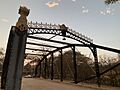
Brackenridge Park Bridge
- Built: 1890
- Location: San Antonio
- Type: A Lenticular truss bridge.
- What makes it special: This bridge is part of the historic Brackenridge Park. Lenticular truss bridges have a unique lens-like shape.
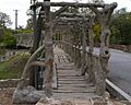
Dionicio Rodriguez Bridge in Brackenridge Park
- Built: Around 1926
- Location: San Antonio
- Type: Faux Bois sculpture.
- What makes it special: This bridge is famous for its artistic design, made to look like natural wood, but it's actually concrete!
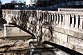
Galveston Causeway
- Built: 1912, with changes in 1922
- Location: Galveston
- Type: A concrete arch.
- What makes it special: This causeway is a long bridge that connects Galveston Island to the mainland.
Hays Street Bridge
- Built: 1908
- Location: San Antonio
- Type: A truss bridge.
- What makes it special: This bridge is part of a group of historic bridges in Texas.
Houston Street Viaduct
- Built: 1910-1911
- Location: Dallas
- Type: A continuous span concrete arch.
- What makes it special: This viaduct is a major historic crossing in Dallas.
These bridges are more than just ways to get from one place to another. They are important parts of Texas history, showing us how people built things, traveled, and connected communities over many years.
Images for kids
-
Almeda Road Bridge
-
Beaver Creek Bridge
-
Bedstead Truss Bridge
-
Bluff Dale Suspension Bridge
-
Brackenridge Park Bridge
-
Brazoria Bridge
-
Bunton Branch Bridge
-
Burr's Ferry Bridge
-
Colorado River Bridge
-
Colorado River Bridge at Bastrop
-
Cow Bayou Swing Bridge
-
Cummins Creek Bridge
-
Deweyville Swing Bridge
-
Dionicio Rodriguez Bridge in Brackenridge Park
-
East Navidad River Bridge
-
Faust Street Bridge
-
Fort Griffin Brazos River Bridge
-
Galveston Causeway
-
Hays Street Bridge
-
Hill Street Bridge
-
Houston Street Viaduct
-
Hubbard Creek Bridge
-
Iron Bridge
-
Kansas City, Mexico and Orient Railway and Gulf, Colorado and Santa Fe Railway Overpass
-
Lamar Boulevard Bridge
-
Lone Wolf Crossing Bridge
-
McKee Street Bridge
-
Medio Creek Bridge
-
Montopolis Bridge
-
Moore's Crossing Bridge
-
Mulberry Creek Bridge
-
Nolan River Bridge 303-A
-
Paddock Viaduct
-
Port Arthur-Orange Bridge
-
Rector Road Bridge at Clear Creek
-
Regency Suspension Bridge
-
Riverside Swinging Bridge
-
Route 66 Bridge over the Chicago, Rock Island and Gulf Railroad
-
Sabine Street Bridge over Buffalo Bayou
-
San Jacinto Street Bridge over Buffalo Bayou
-
State Highway 16 Bridge at the Brazos River
-
State Highway 19 Bridge at Trinity River
-
State Highway 23 Bridge at the Clear Fork of the Brazos River
-
State Highway 27 Bridge at Johnson Fork
-
State Highway 27 Bridge at the Guadalupe River
-
State Highway 27 Bridge at the South Llano River
-
State Highway 29 Bridge at the Colorado River
-
State Highway 3 Bridge at the Colorado River
-
State Highway 3 Bridge at the Nueces River
-
State Highway 3 Bridge at the Trinity River
-
State Highway 35 Bridge at the West Fork of the San Jacinto River
-
State Highway 3-A Bridge at Cibolo Creek
-
State Highway 3-A Bridge at Plum Creek
-
State Highway 53 Bridge at the Leon River
-
State Highway 71 Bridge at the Colorado River
-
State Highway 78 Bridge at the Red River
-
State Highway 79 Bridge at the Red River
-
State Highway 89 Bridge at the Brazos River
-
State Highway 9 Bridge at the Llano River
-
Texas and New Orleans Railroad Bridge
-
Third Street Railroad Trestle
-
US 190 Bridge at the Colorado River
-
US 281 Bridge at the Brazos River
-

Waco Suspension Bridge
-
Washburn Tunnel
-
Washington Avenue Bridge
-
West Fifth Street Bridge at Shoal Creek
-
West Sixth Street Bridge at Shoal Creek
-
Yale Street Bridge over White Oak Bayou


.jpg)


.jpg)
.jpg)


.jpg)


_side.jpg)


.jpg)


