
Niigata (city) facts for kids
Quick facts for kids
Niigata
新潟市
|
|||||||||||||
|---|---|---|---|---|---|---|---|---|---|---|---|---|---|
| Niigata City | |||||||||||||
|
|||||||||||||
|
|||||||||||||

Location of Niigata in Niigata Prefecture
|
|||||||||||||

Niigata
Location in Japan
|
|||||||||||||
| Country | Japan | ||||||||||||
| Region | Chūbu (Kōshin'etsu) (Hokuriku) | ||||||||||||
| Prefecture | Niigata | ||||||||||||
| City Status | April 1, 1889 city incorporation ) | ||||||||||||
| Area | |||||||||||||
| • Designated city | 726.45 km2 (280.48 sq mi) | ||||||||||||
| Population
(July 1, 2019)
|
|||||||||||||
| • Designated city | 797,591 | ||||||||||||
| • Density | 1,097.930/km2 (2,843.625/sq mi) | ||||||||||||
| • Metro
(2015)
|
1,060,013 (17th) | ||||||||||||
| Time zone | UTC+9 (Japan Standard Time) | ||||||||||||
| Phone number | 025-243-4894 | ||||||||||||
| Address | 1-602-1 Gakkōchō-dōri, Chūō-ku, Niigata-shi, Niigata-ken 951-8550 | ||||||||||||
| Climate | Cfa | ||||||||||||
|
|||||||||||||


| Niigata | |||||
|---|---|---|---|---|---|
.svg)
"Niigata" in kanji
|
|||||
| Japanese name | |||||
| Kanji | 新潟 | ||||
|
|||||
Niigata (新潟市 (Niigata-shi, [niːɡata])) is a big city in the northern part of Niigata Prefecture, Japan. It is the capital and largest city of Niigata Prefecture. Niigata is also one of Japan's special "designated cities," which means it has more power to govern itself.
The city is located in the Chūbu region of Japan. It is the most populated city on the west coast of Honshu, Japan's main island. Niigata faces the Sea of Japan and is close to Sado Island. As of September 1, 2022, about 779,049 people lived there. The city covers an area of 726.45 square kilometers. Niigata is known for its large farming areas, especially for rice.
Contents
- Discovering Niigata City
- Niigata's Natural Environment
- Niigata's Past: A Brief History
- Niigata's Global Connections
- Learning in Niigata: Colleges and Universities
- Getting Around Niigata: Transportation Hubs
- Fun Things to See and Do in Niigata
- Niigata's Culture and Traditions
- Famous People from Niigata
- Images for kids
- See also
Discovering Niigata City
Niigata became an official city on April 1, 1889. It has a long history as an important port town. It connected sea travel with river systems like the Shinano and Agano rivers. In 1858, it was chosen as one of five "free treaty ports" for international trade. It officially opened for trade in 1869.
The city government was set up in 1889. In 2005, Niigata grew much larger by joining with nearby towns. This made its population jump to over 810,000 people. It also gave the city the most rice fields in Japan. On April 1, 2007, Niigata became the first "government-designated city" on the Sea of Japan coast of Honshu. The city is divided into eight smaller areas called wards.
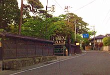
Until the 1950s, Niigata had many canals lined with willow trees in its downtown area. Because of this, people sometimes call it the "City of Water" or "City of Willows." Niigata is also famous for its many manga artists. The city has a large network of bypass roads. Important landmarks include the Bandai Bridge, NEXT21, Toki Messe, Denka Big Swan Stadium, and Niigata Nippo Media Ship.
What Does "Niigata" Mean?
The name "Niigata" was first written down in 1520. In Japanese, "Niigata" (新潟) means "new" (新) and "lagoon" (潟).
No one knows for sure how the name came about, so there are many ideas:
- Some think "Niigata" was a big lagoon at the mouth of the Shinano River.
- Others believe it was an inland bay where the river entered the sea.
- Another idea is that it was the name of a village on an island in the river's mouth.
- Finally, some say it referred to a settlement that moved to the Furumachi district. This settlement then gave its name to a nearby lagoon.
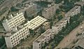
City Views: Niigata's Landscape

-
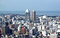
Downtown Niigata City (2012)
-
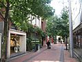
Downtown Furumachi (2013)
-
Toki Messe (2021)
-
River Front Park (2021)
-
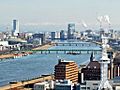
A view of Niigata City and Shinano River from the Niigata Prefecture Building (2022)
-
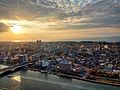
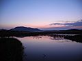
Sunset in Niigata City (2022)


Niigata's Natural Environment
Niigata is located on a flat, fertile plain along the Sea of Japan coast. It faces Sado Island. Two major rivers, the Shinano River and Agano River, flow through the city.
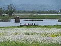
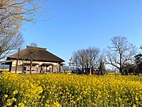
The city has many wetlands, like the Fukushimagata wetlands. The Sakata lagoon is even recognized as an important wetland worldwide. Because Niigata is low and has a lot of water, controlling floods and creating new land have always been important tasks for the city.
Niigata is often called the "City of Water" (水の都 (Mizu-no-miyako)). This is because of its two rivers, its location by the sea, its many wetlands, and the old canals. It's also known as the "City of Willows" (柳の都 (Yanagi-no-miyako) or Ryuto (柳都)) because of the willow trees that once lined the canals. Today, the city also calls itself a "Designated City of Food and Flowers" (食と花の政令市 (Shoku to hana no seireishi)). This highlights its rich agricultural areas outside the city center.
-
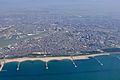
Aerial photo of Niigata
-
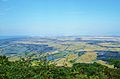
View of Echigo Plain from Mount Kakuda
-
Lake Fukushimagata
-
Lake Sakata


Niigata's Weather and Climate
Niigata City has a humid subtropical climate. This means it has hot, humid summers and mild winters. However, it gets a lot of snow each year, even more than some cities with colder climates. Winters are often very humid with strong winds from the Sea of Japan. Even though other parts of Niigata Prefecture get heavy snow, Niigata City usually gets less. This is because it's low to the ground and Sado Island helps block some snow.
On average, Niigata City has about 269 days of rain or snow each year. The rainy season in July brings a lot of rain. November and December also have much precipitation. In summer, warm winds can make the weather quite hot. Sometimes, strong winds from typhoons can make temperatures even higher than in other parts of Japan.
| Climate data for Niigata (1991−2020 normals, extremes 1881−present) | |||||||||||||
|---|---|---|---|---|---|---|---|---|---|---|---|---|---|
| Month | Jan | Feb | Mar | Apr | May | Jun | Jul | Aug | Sep | Oct | Nov | Dec | Year |
| Record high °C (°F) | 15.3 (59.5) |
21.3 (70.3) |
25.1 (77.2) |
30.7 (87.3) |
32.9 (91.2) |
35.0 (95.0) |
38.5 (101.3) |
39.9 (103.8) |
38.8 (101.8) |
33.3 (91.9) |
27.2 (81.0) |
23.6 (74.5) |
39.9 (103.8) |
| Mean daily maximum °C (°F) | 5.3 (41.5) |
6.4 (43.5) |
10.3 (50.5) |
16.1 (61.0) |
21.3 (70.3) |
24.8 (76.6) |
28.7 (83.7) |
30.8 (87.4) |
26.4 (79.5) |
20.7 (69.3) |
14.3 (57.7) |
8.7 (47.7) |
17.8 (64.0) |
| Daily mean °C (°F) | 2.5 (36.5) |
3.1 (37.6) |
6.2 (43.2) |
11.3 (52.3) |
16.7 (62.1) |
20.9 (69.6) |
24.9 (76.8) |
26.5 (79.7) |
22.5 (72.5) |
16.7 (62.1) |
10.5 (50.9) |
5.3 (41.5) |
13.9 (57.0) |
| Mean daily minimum °C (°F) | 0.1 (32.2) |
−0.1 (31.8) |
2.4 (36.3) |
7.0 (44.6) |
12.7 (54.9) |
17.7 (63.9) |
21.8 (71.2) |
23.3 (73.9) |
19.0 (66.2) |
12.8 (55.0) |
6.9 (44.4) |
2.4 (36.3) |
10.5 (50.9) |
| Record low °C (°F) | −11.7 (10.9) |
−13.0 (8.6) |
−6.4 (20.5) |
−2.5 (27.5) |
2.0 (35.6) |
6.7 (44.1) |
11.4 (52.5) |
14.5 (58.1) |
7.9 (46.2) |
3.0 (37.4) |
−1.8 (28.8) |
−9.5 (14.9) |
−13.0 (8.6) |
| Average precipitation mm (inches) | 180.9 (7.12) |
115.8 (4.56) |
112.0 (4.41) |
97.2 (3.83) |
94.4 (3.72) |
121.1 (4.77) |
222.3 (8.75) |
163.4 (6.43) |
151.9 (5.98) |
157.7 (6.21) |
203.5 (8.01) |
225.9 (8.89) |
1,845.9 (72.67) |
| Average snowfall cm (inches) | 63 (25) |
48 (19) |
8 (3.1) |
0 (0) |
0 (0) |
0 (0) |
0 (0) |
0 (0) |
0 (0) |
0 (0) |
0 (0) |
19 (7.5) |
139 (55) |
| Average precipitation days (≥ 0.5 mm) | 23.3 | 19.0 | 17.4 | 13.3 | 11.3 | 10.6 | 13.6 | 10.9 | 13.5 | 15.2 | 19.2 | 24.1 | 191.4 |
| Average relative humidity (%) | 72 | 74 | 68 | 66 | 69 | 74 | 79 | 75 | 73 | 72 | 74 | 74 | 72 |
| Mean monthly sunshine hours | 56.4 | 74.3 | 136.8 | 177.7 | 202.8 | 179.2 | 162.1 | 205.2 | 156.2 | 138.2 | 91.5 | 62.9 | 1,639.6 |
| Source: Japan Meteorological Agency | |||||||||||||
| Climate data for Nishikan-ku (1991−2020 normals, extremes 1978−present) | |||||||||||||
|---|---|---|---|---|---|---|---|---|---|---|---|---|---|
| Month | Jan | Feb | Mar | Apr | May | Jun | Jul | Aug | Sep | Oct | Nov | Dec | Year |
| Record high °C (°F) | 14.8 (58.6) |
21.6 (70.9) |
23.2 (73.8) |
29.2 (84.6) |
32.2 (90.0) |
33.2 (91.8) |
36.9 (98.4) |
38.9 (102.0) |
38.6 (101.5) |
32.4 (90.3) |
24.8 (76.6) |
18.9 (66.0) |
38.9 (102.0) |
| Mean daily maximum °C (°F) | 5.2 (41.4) |
5.9 (42.6) |
9.9 (49.8) |
16.0 (60.8) |
21.4 (70.5) |
24.8 (76.6) |
28.3 (82.9) |
30.2 (86.4) |
26.4 (79.5) |
20.4 (68.7) |
14.2 (57.6) |
8.2 (46.8) |
17.6 (63.6) |
| Daily mean °C (°F) | 2.1 (35.8) |
2.2 (36.0) |
5.3 (41.5) |
10.7 (51.3) |
16.4 (61.5) |
20.4 (68.7) |
24.3 (75.7) |
25.6 (78.1) |
21.6 (70.9) |
15.6 (60.1) |
9.7 (49.5) |
4.6 (40.3) |
13.2 (55.8) |
| Mean daily minimum °C (°F) | −0.7 (30.7) |
−1.1 (30.0) |
1.0 (33.8) |
5.6 (42.1) |
12.1 (53.8) |
16.8 (62.2) |
21.0 (69.8) |
21.9 (71.4) |
17.7 (63.9) |
11.2 (52.2) |
5.6 (42.1) |
1.4 (34.5) |
9.4 (48.9) |
| Record low °C (°F) | −13.1 (8.4) |
−12.0 (10.4) |
−7.5 (18.5) |
−3.2 (26.2) |
4.0 (39.2) |
8.8 (47.8) |
13.4 (56.1) |
12.7 (54.9) |
7.1 (44.8) |
1.8 (35.2) |
−5.4 (22.3) |
−12.2 (10.0) |
−13.1 (8.4) |
| Average precipitation mm (inches) | 165.2 (6.50) |
99.8 (3.93) |
99.9 (3.93) |
90.9 (3.58) |
85.2 (3.35) |
117.0 (4.61) |
213.3 (8.40) |
154.2 (6.07) |
130.4 (5.13) |
136.1 (5.36) |
190.2 (7.49) |
222.8 (8.77) |
1,704.1 (67.09) |
| Average precipitation days (≥ 1.0 mm) | 20.1 | 16.2 | 15.9 | 11.8 | 10.3 | 9.9 | 12.5 | 10.1 | 11.7 | 13.6 | 17.5 | 20.6 | 170.2 |
| Mean monthly sunshine hours | 47.9 | 71.2 | 129.9 | 171.5 | 195.0 | 174.9 | 157.8 | 182.4 | 139.1 | 126.0 | 85.4 | 49.6 | 1,530.7 |
| Source: Japan Meteorological Agency | |||||||||||||
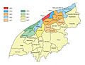
Niigata's Wards: How the City is Divided
Niigata is divided into eight special areas called "wards" (ku). Each ward has its own special "image color."
| Wards of Niigata | ||||
|---|---|---|---|---|
| Place Name | Map of Niigata | |||
| Rōmaji | Kanji | Color | ||
| 1 | Akiha Ward | 秋葉区 | ■ Floral green |
 |
| 2 | Chuo Ward (administrative center) | 中央区 | ■ Waterfront blue | |
| 3 | Higashi Ward | 東区 | ■ Aqua blue | |
| 4 | Kita Ward | 北区 | ■ Nature green | |
| 5 | Konan Ward | 江南区 | ■ Spring green | |
| 6 | Minami Ward | 南区 | ■ Breeze blue | |
| 7 | Nishi Ward | 西区 | ■ Sunset orange | |
| 8 | Nishikan Ward | 西蒲区 | ■ Harvest yellow | |

Niigata's Past: A Brief History
Early Times and Middle Ages
People have lived in the Niigata area since the Jōmon period, which was a very long time ago. Back then, much of the land we see today was still under the sea. A fort was built in the area around the year 647 AD.
In the 1500s, a port called Niigata was created where the Shinano River met the sea. Another port town, Nuttari, grew at the mouth of the Agano River. The area did very well under the rule of Uesugi Kenshin during the Sengoku Period.
Modern History and Growth
In the 1600s, a system of canals was built in downtown Niigata. Over time, the Shinano and Agano rivers changed their paths and both flowed into the Sea of Japan at the same spot. This helped Niigata become a busy port town. It was a stop for Japanese trade ships traveling along the Sea of Japan.
In 1730, the Matsugasaki Canal was built to help drain the Agano River area. But in 1731, a flood destroyed the canal, and it became the main path for the Agano River. This change meant less water flowed into Niigata's port, which allowed for new land to be created and more rice fields to be developed.
- Gallery
-
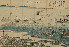
Nishiki-e "Niigata Minato no Shinkei" (View of Niigata Port), 1859
-
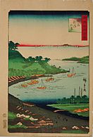
Niigata drawn by Utagawa Hiroshige in 1859


In 1858, Niigata was chosen as one of five ports to open for international trade by the Japan–U.S. Treaty of Amity and Commerce. However, the port was too shallow for large foreign ships, so it didn't fully open until 1869. The port was also important for fishermen who traveled far north to catch fish.
The first Bandai Bridge was built across the Shinano River in 1886. It connected the towns of Niigata and Nuttari. Niigata then took over Nuttari in 1914. During World War II, Niigata was a key location for moving people and soldiers to other parts of Asia.
Recent Times and Challenges
In 1945, near the end of World War II, Niigata was considered a possible target for atomic bombs. However, it was not bombed. This might have been due to bad weather, its distance from air bases, or other reasons. After the second atomic bombing in Nagasaki, the governor of Niigata ordered everyone to leave the city. The city was empty for days until the war ended.
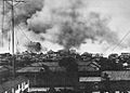
A big typhoon and fire in 1955 destroyed much of downtown Niigata. But the city recovered. In 1958, the new Niigata Station was finished, expanding the downtown area. In 1964, the old canals in the city were filled in to make more roads.
On June 16, 1964, a strong earthquake hit Niigata. It caused a lot of damage and changed the ground in a process called liquefaction. In 1965, the Agano River became polluted with a chemical called methylmercury. This caused a health problem known as Niigata Minamata disease.
- Gallery
-
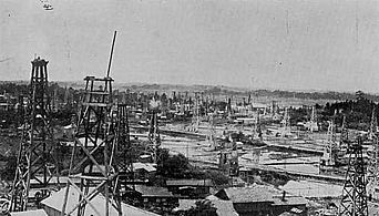
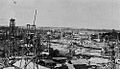
Niitsu Oil Field (1930s)
-

The 1955 fire of Niigata
-
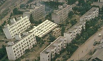
Some effects of liquefaction during the 1964 Niigata earthquake


In 1982, the Jōetsu Shinkansen (bullet train) started running between Niigata and Omiya. It was later extended to Tokyo in 1991. The Big Swan Stadium in Niigata hosted three games during the 2002 FIFA World Cup. In 2004 and 2007, earthquakes hit the Niigata Prefecture. Niigata City itself had little damage and was able to help other affected areas.
Niigata City grew in size and population between 2001 and 2005 by joining with more towns. In 2008, the city hosted a meeting for G8 Labor Ministers. On March 12, 2011, a large earthquake off Japan's east coast also caused a strong shake in Niigata.
How Niigata Grew: City Mergers
Niigata City has grown over the years by merging with many smaller towns and villages. Here are some key mergers:
- April 1, 1889: The village of Sekiya joined the town of Niigata to form the city of Niigata.
- April 1, 1914: The town of Nuttari merged into Niigata City.
- 2001-2005: Many more towns and villages joined Niigata City, making it much larger.
- October 10, 2005: The town of Maki merged into the expanded city of Niigata.
Niigata's Global Connections
Niigata has "sister city" relationships with six cities around the world. These partnerships help build friendships and cultural exchange.
Sister Cities
| City | Country | State | Since |
|---|---|---|---|
| Galveston | Texas | January 28, 1965 | |
| Khabarovsk | Khabarovsk Krai | April 23, 1965 | |
| Vladivostok | Primorsky Krai | February 28, 1991 | |
| Birobidzhan | Jewish Autonomous Oblast | August 6, 1992 (once a sister city of Toyosaka, Niigata assumed the sister city honors in 2005) | |
| Nantes | Pays de la Loire | January 31, 2009 (shifted from friendship city since 1999) |
Friendship Cities
| City | Country | State | since |
|---|---|---|---|
| Harbin | Heilongjiang | December 17, 1979 |
Partnership Cities
Niigata also has special exchange agreements with other cities:
 Kingston upon Hull, United Kingdom
 Ulsan, South Korea (since September 2007)
National Partnerships in Japan
Niigata also partners with cities within Japan:
| City | Prefecture | region | Since |
|---|---|---|---|
| Hakodate | Hokkaidō region | 1993 (Treaty ports Partnership) | |
| Yokohama | Kantō region | 1993 (Treaty ports Partnership) | |
| Kobe | Kansai region | 1993 (Treaty ports Partnership) | |
| Nagasaki | Kyushu region | 1993 (Treaty ports Partnership) | |
| Sado | Chūbu region | August 1, 2008 | |
| Aizuwakamatsu | Tōhoku region | July 22, 2012 | |
| Kyoto | Kansai region | March 26, 2013 |
Learning in Niigata: Colleges and Universities

Niigata is home to several colleges and universities, offering many study options:
- Niigata University
- University of Niigata Prefecture
- Niigata Seiryo University
- The Nippon Dental University School of Life Dentistry at Niigata
- Niigata University of Pharmacy and Applied Life Sciences
- International University of Japan
- Niigata University of International and Information Studies
- Niigata University of Health and Welfare
- Graduate Institute for Entrepreneurial Studies
- College of Biomedical Technology Niigata University
- Niigata Agro-Food University
Getting Around Niigata: Transportation Hubs


Air Travel: Niigata Airport
Niigata Airport is about 6 kilometers north of the city center. It has flights to other cities in Japan and some international destinations. As of October 2016, you could fly to places like Osaka, Sapporo, Fukuoka, Okinawa, Nagoya, Narita, and Sado Island. International flights went to Harbin, Seoul, Shanghai, and Vladivostok.
Train Travel: Niigata Station
Niigata Station is the biggest train station in the city. It's in the Bandai area, a main shopping district. About 37,000 people use the station every day. The Jōetsu Shinkansen (bullet train) starts here and goes to Tokyo. Other train lines like the Shin'etsu Main Line and Hakushin Line also stop at Niigata Station. These lines connect Niigata to many other cities.
High-Speed Rail
- East Japan Railway Company (JR East)
- Jōetsu Shinkansen: - Niigata
Local Train Lines
- East Japan Railway Company (JR East)
- Shin'etsu Main Line: - Niigata - Echigo-Ishiyama - Kameda - Ogikawa - Satsukino - Niitsu - Furutsu - Yashiroda
- Hakushin Line: Niigata - Higashi-Niigata - Ōgata - Niizaki - Hayadōri - Toyosaka - Kuroyama
- Echigo Line: Niigata - Hakusan - Sekiya - Aoyama - Kobari - Terao - Niigata University - Uchino - Uchino-Nishigaoka - Echigo-Akatsuka - Echigo-Sone - Maki - Iwamuro - Yoshida
Bus Services
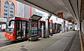
A special bus rapid transit (BRT) line called "Bandai-bashi Line" runs through the main business and shopping areas of central Niigata. It connects Niigata Station, Bandai Bridge, Furumachi, the City Hall, Hakusan Station, and Aoyama.
Roads and Highways
Expressways
 Nihonkai-Tōhoku Expressway
 Hokuriku Expressway
 Ban-etsu Expressway
Japan National Route
 National Route 7
 National Route 9
 National Route 49
 National Route 113
 National Route 116
 National Route 289
 National Route 345
 National Route 350
 National Route 402
 National Route 403
 National Route 459
 National Route 460
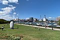
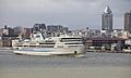
Sea Travel: Port of Niigata
The Port of Niigata has been important for sea trade for hundreds of years. It was one of the five ports opened for international trade in 1858. The port has areas for both passengers and cargo. It is considered an "international hub port" by the government. You can take ferries from Niigata to Sado Island, Otaru, Akita, and Tsuruga.
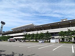
-
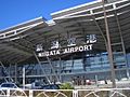
Niigata Airport
-
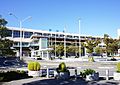
Niigata Station
-
Bandai-bashi Line (BRT)
-
Port of Niigata


Fun Things to See and Do in Niigata
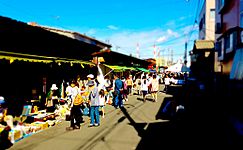
- Furumachi and Bandai City are popular downtown shopping areas.
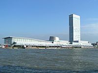
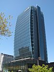
- Toki Messe, Next21, Niigata Nippo Media Ship, and Niigata Prefectural Government Office are tall buildings with observation decks where you can see great views of the city.
- Nuttari Terrace is a charming area with unique shops.
- Pier Bandai is a lively market by the water.
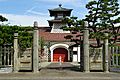
- Visit the Niigata City History Museum (Minatopia) to learn about the city's past.
- The Northern Culture Museum shows traditional Japanese architecture and gardens.
- See marine life at Marinepia Nihonkai Aquarium.
- Explore nature at Fukushimagata Lagoon Park.
- Relax at Iwamuro Onsen, a hot spring resort.
- Enjoy beautiful plants at the Niigata Prefectural Botanical Garden.
- The Nature Aquarium Gallery displays amazing underwater landscapes.
-
Toki Messe
-
Niigata Nippo Media Ship
-
Nuttari Terrace
-
Fukushimagata Lagoon Park
-
Iwamuro Onsen


Niigata's Culture and Traditions

Niigata has its own geisha culture that started over 200 years ago during the Edo period. This tradition grew because the city was a busy port. In Niigata, these performers are called geigi. Many ochaya (places where geigi perform) are in the Furumachi neighborhood, like the famous Nabechaya.
Exciting Events in Niigata
- Niigata Festival happens every August.
- Kambara Festival is another popular local festival.
- Niigata Comic Market is a big event for comic and manga fans.
- The Niigata Manga Competition celebrates new manga artists.
- The Kurosaki Festival is a fun local celebration.
Delicious Foods to Try in Niigata
Niigata is known for its tasty local dishes:
- Tare Katsudon: A bowl of rice topped with a deep-fried pork cutlet and a special sauce.
- Noppe: A traditional Japanese stew with vegetables and sometimes seafood.
- Kakinomoto: A type of edible chrysanthemum.
- Sasa Dango: A sweet dumpling wrapped in bamboo leaves.
- Mikazuki Italian Noodle: A unique local noodle dish.
- Assari-Shōyu Ramen: A light soy sauce flavored ramen.


Sports Teams in Niigata
Niigata is home to several professional sports teams:
| Club | Sport | League | Venue | Established |
|---|---|---|---|---|
| Albirex Niigata | Football | J.League | Denka Big Swan Stadium | 1955 |
| Niigata Albirex BB | Basketball | B.League | Niigata City Higashi General Sports Center, City Hall Plaza Aore Nagaoka, Toki Messe | 2000 |
| Albirex Niigata Ladies | Women's soccer | WE.League | Niigata Athletic Stadium | 2002 |
| Niigata Albirex Baseball Club | Baseball | BC.League | Niigata Prefectural Baseball Stadium | 2005 |
-
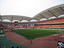
Denka Big Swan Stadium
-
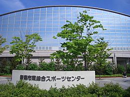
Niigata City Higashi General Sports Center
-
Niigata Athletic Stadium
-
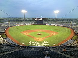
Niigata Prefectural Baseball Stadium


Famous People from Niigata
Many talented people come from Niigata, including artists, writers, actors, and musicians.
Artists and Writers
- Yaichi Aizu, a poet and historian.
- Koichi Endo, a manga artist.
- Shu Fujisawa, a writer.
- Makoto Kobayashi, a manga artist.
- Mineo Maya, a manga artist.
- Shinji Mizushima, a manga artist.
- Tadashi Nakayama, a woodblock artist.
- Takeshi Obata, a manga artist.
- One, a manga artist.
- Ango Sakaguchi, an author.
- Rumiko Takahashi, a famous manga artist.
Actors and Voice Actors
- Fumika Baba, actress.
- Mina Fujii, actress.
- Toshihito Ito, actor.
- Masashi Mikami, actor.
- Bin Shimada, a voice actor.
- Keiko Yokozawa, a voice actor.
Musicians
- coba, an accordion player and composer.
- Double, a singer.
- Yoko Ishida, a singer.
- Katsutaro Kouta, a singer.
- Közi, a guitarist from the bands Malice Mizer and Eve of Destiny.
- NGT48, an idol group.
- Rina Sawayama, a singer-songwriter and model.
- Akira Yamaoka, a composer.
- samfree, a vocaloid music composer.
Other Notable People
- Takashi Amano, a professional aquarist and cyclist.
- Kunio Maekawa, an architect.
- SANADA (Seiya Sanada), a professional wrestler.
- Tadao Sato, a film critic.
- Megumi Sato, a high jumper.
- Meiko Satomura, a professional wrestler.
- Yujiro Takahashi, a professional wrestler.
- Yutakayama Ryota, a sumo wrestler.
Images for kids
-
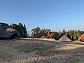
Furutsu Hachimanyama Site
-
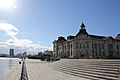
Niigata City History Museum (Minatopia)
-
Old Niigata Customs Government Building
-
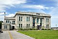
Former Daishi Bank Sumiyoshi-cho Branch
-
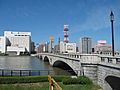
Bandai Bridge
-
Niitsu Oil Field (1930s)
-
The 1955 fire of Niigata
-
Some effects of liquefaction during the 1964 Niigata earthquake
-
Mergers of Niigata


See also
 In Spanish: Niigata (Niigata) para niños
