Norfolk County, Massachusetts facts for kids
Quick facts for kids
Norfolk County
|
|||
|---|---|---|---|
|
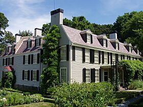
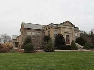
Images, from top down, left to right: Former residence of John Adams in Quincy; Trail in the Blue Hills Reservation; MBTA station in Brookline; Green Hall at Wellesley College
|
|||
|
|||
| Motto(s):
Antiquity, Perseverance, History, Industry
|
|||
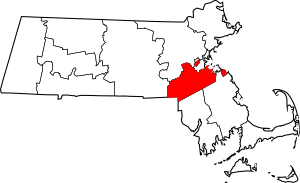
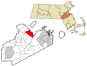
Location within the U.S. state of Massachusetts
|
|||
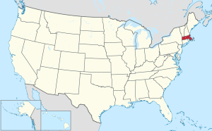 Massachusetts's location within the U.S. |
|||
| Country | |||
| State | |||
| Founded | 1793 | ||
| Named for | Norfolk | ||
| Seat | Dedham | ||
| Largest city | Quincy | ||
| Area | |||
| • Total | 444 sq mi (1,150 km2) | ||
| • Land | 396 sq mi (1,030 km2) | ||
| • Water | 48 sq mi (120 km2) 11%% | ||
| Population
(2020)
|
|||
| • Total | 725,981 | ||
| • Estimate
(2023)
|
727,473 |
||
| • Density | 1,635.1/sq mi (631.3/km2) | ||
| Time zone | UTC−5 (Eastern) | ||
| • Summer (DST) | UTC−4 (EDT) | ||
| Congressional districts | 2nd, 4th, 7th, 8th | ||
Norfolk County is a county located in the U.S. state of Massachusetts. In 2020, about 725,981 people lived there. Its main town, or county seat, is Dedham. Norfolk County is special because its county seat, Dedham, is a town, not a city. It is the second most populated county in the U.S. with a town as its seat.
The county got its name from the English county of Norfolk. Two towns, Cohasset and Brookline, are "exclaves." This means they are part of Norfolk County but are separated from the main part of the county. Norfolk County is also part of the larger Boston area. It is known as the wealthiest county in Massachusetts.
Contents
History of Norfolk County
Norfolk County was officially created on March 26, 1793. This happened after Governor John Hancock signed a new law. Most of the towns that became part of Norfolk County were originally from Suffolk County, Massachusetts.
Some towns like Dorchester and Roxbury were first in Norfolk County. But as the city of Boston grew and took over these towns, they became part of Suffolk County again. This left Brookline separated from the rest of Norfolk County. Also, Hingham and Hull were supposed to be in Norfolk County. However, they asked to stay in Suffolk County. Later, in 1803, they moved to Plymouth County, Massachusetts. This made Cohasset an "exclave" too.
Norfolk County is famous for being the birthplace of four U.S. Presidents: John Adams, John Quincy Adams, John F. Kennedy, and George H. W. Bush. Because of this, it's often called the "County of Presidents."
Jails in Norfolk County
After the county was formed, officials decided to build a jail. The first jail was built in 1795 next to a place called Gay's Tavern.
This first jail was replaced by a new one in 1817. The new jail was a two-story stone building. Over time, it was changed and made bigger. In 1992, a new and modern jail, the Norfolk County Correctional Center, was opened. This new center is located in Dedham and has space for 502 people.
Courthouses in Norfolk County
When Norfolk County was new, the courts first met in Dedham's meetinghouse. It was so cold there in the winter that they sometimes had to move to a warmer place like the Woodward Tavern.
A new courthouse was finished in 1795. However, it was soon found to be too small. So, a famous architect named Charles Bulfinch was hired to add a tower. Paul Revere even made a bell for the building!
Later, county leaders decided they needed an even newer, bigger courthouse. Land was bought for this new building in 1825. The new courthouse was designed by Solomon Willard and opened in 1827. It was a large granite building with tall pillars. The bell made by Paul Revere was moved to this new building.
Even though it looked nice, the new courthouse wasn't very comfortable inside. It didn't have good heating or water.
Registry of Deeds Building
The Registry of Deeds is where important property documents are kept. It was first located in the home of the first registrar, Eliphalet Pond. Later, it moved to the first Norfolk County Courthouse.
As the county grew, more space was needed for these important records. So, a new building was built just for the Registry of Deeds in 1905. This building is made of Indiana limestone and granite.
Geography of Norfolk County
Norfolk County covers about 444 square miles. About 396 square miles are land, and 48 square miles (11%) are water. It is the third-smallest county in Massachusetts by total area.
As mentioned, Norfolk County is not all connected. The towns of Brookline and Cohasset are part of the county but are separated from the main area. This happened because some towns that were originally part of Norfolk County later joined other counties or Boston.
Neighboring Counties
- Middlesex County (to the northwest)
- Suffolk County (to the north)
- Plymouth County (to the southeast)
- Bristol County (to the south)
- Providence County, Rhode Island (to the southwest)
- Worcester County (to the west)
Special Protected Areas
Norfolk County is home to several important national protected areas:
- Adams National Historical Park
- Boston Harbor Islands National Recreation Area (part of it)
- Frederick Law Olmsted National Historic Site
- John Fitzgerald Kennedy National Historic Site
Main Roads and Highways
Population and People
| Historical population | |||
|---|---|---|---|
| Census | Pop. | %± | |
| 1800 | 27,216 | — | |
| 1810 | 31,245 | 14.8% | |
| 1820 | 36,471 | 16.7% | |
| 1830 | 41,972 | 15.1% | |
| 1840 | 53,140 | 26.6% | |
| 1850 | 78,892 | 48.5% | |
| 1860 | 109,950 | 39.4% | |
| 1870 | 89,443 | −18.7% | |
| 1880 | 96,507 | 7.9% | |
| 1890 | 118,950 | 23.3% | |
| 1900 | 151,539 | 27.4% | |
| 1910 | 187,506 | 23.7% | |
| 1920 | 219,081 | 16.8% | |
| 1930 | 299,426 | 36.7% | |
| 1940 | 325,180 | 8.6% | |
| 1950 | 392,308 | 20.6% | |
| 1960 | 510,256 | 30.1% | |
| 1970 | 605,051 | 18.6% | |
| 1980 | 606,587 | 0.3% | |
| 1990 | 616,087 | 1.6% | |
| 2000 | 650,308 | 5.6% | |
| 2010 | 670,850 | 3.2% | |
| 2020 | 725,981 | 8.2% | |
| 2023 (est.) | 727,473 | 8.4% | |
| U.S. Decennial Census 1790-1960 1900-1990 1990-2000 2010-2020 |
|||
How Many People Live Here?
In 2010, there were 670,850 people living in Norfolk County. The county had about 257,914 households. The population density was about 1,693 people per square mile.
Most people in the county (82.3%) were white. About 8.6% were Asian, and 5.7% were black or African American. People of Hispanic or Latino origin made up 3.3% of the population.
Many people in Norfolk County have Irish (31.8%), Italian (15.5%), or English (11.0%) backgrounds. Other common backgrounds include German, French, and Chinese.
About 32.2% of households had children under 18 living with them. The average age of people in the county was 40.7 years old. The median income for a household was about $81,027. This means half the households earned more than this, and half earned less.
Communities in Norfolk County
Cities
Towns
Some towns that were once part of Norfolk County, like West Roxbury, Roxbury, Dorchester, Hyde Park, Hingham, and Hull, later became part of Boston or Plymouth County.
Census-Designated Places
These are areas that are identified for census purposes but are not officially incorporated towns or cities.
Education in Norfolk County
Norfolk County has many school districts. Here are some of them:
K-12 School Districts
These districts offer schooling from kindergarten all the way through 12th grade.
- Avon School District
- Bellingham School District
- Braintree School District
- Brookline School District
- Canton School District
- Cohasset School District
- Dedham School District
- Foxborough School District
- Franklin School District
- Holbrook School District
- Medfield School District
- Medway School District
- Millis School District
- Milton School District
- Needham School District
- Norwood School District
- Quincy School District
- Randolph School District
- Sharon School District
- Stoughton School District
- Walpole School District
- Wellesley School District
- Westwood School District
- Weymouth School District
High School Districts
These districts focus on high school education.
- Dover-Sherborn School District
- King Philip School District
Elementary School Districts
These districts focus on elementary school education.
- Dover School District
- Norfolk School District
- Plainville School District
- Wrentham School District
Regional Vocational High Schools
These schools offer special training for jobs and trades.
- Blue Hills Regional Technical
- Norfolk County Agricultural
- Tri-County Regional Vocational Technical
Images for kids
See also
 In Spanish: Condado de Norfolk (Massachusetts) para niños


