Ontonagon County, Michigan facts for kids
Quick facts for kids
Ontonagon County
|
|
|---|---|
|
|
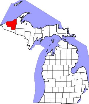
Location within the U.S. state of Michigan
|
|
 Michigan's location within the U.S. |
|
| Country | |
| State | |
| Founded | March 9, 1843 1848 organized |
| Named for | Ontonagon River |
| Seat | Ontonagon |
| Largest village | Ontonagon |
| Area | |
| • Total | 3,741 sq mi (9,690 km2) |
| • Land | 1,311 sq mi (3,400 km2) |
| • Water | 2,430 sq mi (6,300 km2) 65%% |
| Population
(2020)
|
|
| • Total | 5,816 |
| • Density | 5.2/sq mi (2.0/km2) |
| Time zone | UTC−5 (Eastern) |
| • Summer (DST) | UTC−4 (EDT) |
| Congressional district | 1st |
| Website | http://ontonagoncounty.org/ |
Ontonagon County is a county in the Upper Peninsula of Michigan. In 2020, about 5,816 people lived here. This makes it Michigan's third smallest county by population. The main town, called the county seat, is Ontonagon.
The county was first created in 1843. It was officially organized in 1848. Before that, its land was part of Chippewa and Mackinac counties. As more people moved in, new counties were formed. Later, part of Ontonagon County was used to create Gogebic County. Ontonagon County is also the westernmost county in the United States that is entirely in the Eastern Time Zone.
Contents
History of Ontonagon County
In 1843, Michigan's Upper Peninsula was divided into several counties. These included Mackinac, Chippewa, Marquette, Schoolcraft, Delta, and Ontonagon Counties.
In 1845, a piece of Ontonagon County became part of Houghton County. The village of Ontonagon was chosen as the county seat in 1846.
Ontonagon County is part of a region called Copper Country. This area was famous for copper mining from 1845 until the late 1960s. Long before Europeans arrived, local Native American groups mined copper here. Europeans first tried to mine copper in the Ontonagon River area in 1771. A large copper rock, known as the Ontonagon Copper Boulder, was taken from the river in 1842. It weighed 3,708 pounds and is now at the Smithsonian Institution. The last copper mine in Copper Country, the White Pine mine, closed in 1995.
What Does Ontonagon Mean?
The county is named after the Ontonagon River. The name is thought to come from an Ojibwe language word. Noojitoon ziibi means "hunting river." A French map from 1670 showed the river as Nantounagon. Another idea is that it comes from the Ojibwa word onagon, which means "dish" or "bowl."
Geography of Ontonagon County
The US Census Bureau says the county covers a total area of 3,741 square miles. About 1,311 square miles are land, and 2,430 square miles (65%) are water. This makes it the third-largest county in Michigan by total area.
Ontonagon County is in the western part of the Upper Peninsula. It sits along the shore of Lake Superior. It is the westernmost county in the United States that is completely within the Eastern Time Zone.
Important Geographic Features
- Porcupine Mountains
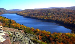
- Lake of the Clouds
- Lake Superior
- Lake Gogebic is the largest lake in the Upper Peninsula.
- Ontonagon River
- Firesteel River
- Flintsteel River
Neighboring Counties
By land
- Houghton County (east)
- Iron County (southeast; Central Time Zone border)
- Gogebic County (south, southwest; Central Time Zone border)
By water
- Ashland County, Wisconsin (west; Central Time Zone border)
- Cook County, Minnesota (northwest; Central Time Zone border)
- Keweenaw County (northeast)
Protected Natural Areas
- Keweenaw National Historical Park (part of it is in the county)
- Ottawa National Forest (part of it is in the county)
Transportation in Ontonagon County
Major Highways
 US 45 – This highway runs north and south through the eastern-central part of the county. It enters from Watersmeet in the south. It passes through Paulding, Bruce Crossing, and Rockland, ending in Ontonagon.
 M-26 – This highway enters the county from the east. It runs southwest, going through Mass City and Lake Mine. It meets M-38 east of Rockland.
 M-28 – This highway runs east and west through the southern part of the county. It then continues west into Gogebic County.
 M-38 – This highway enters the county from the east, near Mass City. It runs west to Lake Mine, then northwest to Ontonagon.
 M-64 – This highway runs north and south through the middle of the county. It enters from the south, on the west side of Lake Gogebic. It runs north to the Lake Superior shoreline. Then it goes northeast along the shoreline to Ontonagon.
Airport
 The Ontonagon County Airport (KOGM) serves the county and nearby towns.
Population and People
| Historical population | |||
|---|---|---|---|
| Census | Pop. | %± | |
| 1850 | 389 | — | |
| 1860 | 4,568 | 1,074.3% | |
| 1870 | 2,845 | −37.7% | |
| 1880 | 2,565 | −9.8% | |
| 1890 | 3,756 | 46.4% | |
| 1900 | 6,197 | 65.0% | |
| 1910 | 8,650 | 39.6% | |
| 1920 | 12,428 | 43.7% | |
| 1930 | 11,114 | −10.6% | |
| 1940 | 11,359 | 2.2% | |
| 1950 | 10,282 | −9.5% | |
| 1960 | 10,584 | 2.9% | |
| 1970 | 10,548 | −0.3% | |
| 1980 | 9,861 | −6.5% | |
| 1990 | 8,854 | −10.2% | |
| 2000 | 7,818 | −11.7% | |
| 2010 | 6,780 | −13.3% | |
| 2020 | 5,816 | −14.2% | |
| 2023 (est.) | 5,906 | −12.9% | |
| US Decennial Census 1790-1960 1900-1990 1990-2000 2010-2018 |
|||
In 2010, the 2010 United States census showed Ontonagon County had 6,780 people. There were 3,258 households and 1,954 families. The population density was about 6 people per square mile. There were 5,672 housing units.
In 2010, most people (97.3%) were White. About 1.1% were Native American. A small number were Asian (0.2%), Black (0.1%), or from other races. About 1.3% were of two or more races. About 0.9% were Hispanic or Latino. By 2020, the population had gone down to 5,816 people.
In 2010, about 15.8% of households had children under 18. About 50.3% were married couples. About 6.0% were female householders without a husband. And 40.0% were not families. Many households (34.8%) were made up of single people. About 17.0% had someone living alone who was 65 or older. The average household had 2.06 people, and the average family had 2.61 people.
The population's age breakdown in 2010 was:
- 15.8% under 18
- 4.1% from 18 to 24
- 16.7% from 25 to 44
- 37.0% from 45 to 64
- 26.3% 65 or older
The average age was 52.7 years. The population was 51.6% male and 48.4% female.
In 2010, the average income for a household was $34,786. For a family, it was $46,845. The income per person was $22,195. About 9.0% of families and 14.3% of the population lived below the poverty line. This included 22.2% of those under 18 and 6.7% of those 65 or older. By 2021, the average household income had grown to $44,605.
Towns and Communities
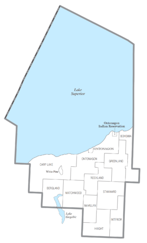
Village
- Ontonagon (This is the county seat, the main town)
Townships
- Bergland Township
- Bohemia Township
- Carp Lake Township
- Greenland Township
- Haight Township
- Interior Township
- Matchwood Township
- McMillan Township
- Ontonagon Township
- Rockland Township
- Stannard Township
Census-Designated Places
These are areas the census bureau defines for statistics.
- Bergland
- Bruce Crossing
- Ewen
- Greenland
- Lake Gogebic
- Mass City
- Rockland
- White Pine
Other Communities
These are smaller, unincorporated places.
- Agate
- Algonquin
- Calderwood
- Carp Lake
- Craigsmere
- Maple Grove
- Matchwood
- Paulding
- Paynesville
- Robbins
- Trout Creek
- Victoria
Ghost Town
Indian Reservation
- The Ontonagon Indian Reservation is a part of the Lake Superior Chippewa tribe. It is located in the northeastern part of Ontonagon Township, along Lake Superior. The reservation covers about 3.775 square miles of land.
See also
 In Spanish: Condado de Ontonagon para niños


