
Parinacota (volcano) facts for kids
Quick facts for kids ParinacotaParina Quta |
|
|---|---|
com.jpg)
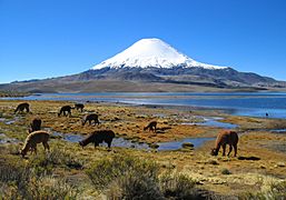
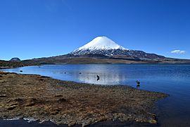
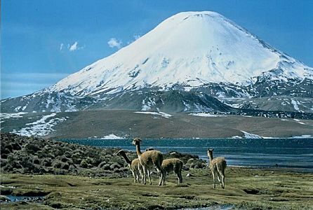
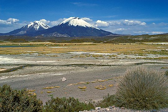
Parinacota and Chungará Lake
|
|
| Highest point | |
| Elevation | 6,380 m (20,930 ft) |
| Listing | Ultra |
| Geography | |

Parinacota
Parina Quta Location in Bolivia
|
|
| Location | Bolivia – Chile border |
| Parent range | Andes |
| Geology | |
| Mountain type | Stratovolcano |
| Volcanic arc/belt | Central Volcanic Zone |
| Last eruption | 290 CE ± 300 years |
| Climbing | |
| First ascent | 1928 |
| Easiest route | snow/rock scramble |
Parinacota (also called Parina Quta or Parinaquta) is a huge, cone-shaped dormant volcano (a stratovolcano). It sits right on the border between Bolivia and Chile. Parinacota is part of the Andes mountain range.
This volcano is 6,380 meters (about 20,932 feet) tall. It has a large summit crater at its top. On its lower southern slopes, there are three smaller cones called Ajata cones. These cones have produced lava flows. Parinacota is part of a volcanic chain called the Nevados de Payachata, which it forms with its neighbor, Pomerape.
Long ago, a huge part of Parinacota's side collapsed. This caused a giant volcanic landslide. The landslide created or made Lake Chungará bigger. Many other lakes also formed in the area. After this collapse, the volcano rebuilt itself.
Parinacota has erupted many times in the past. The last eruption was about 200 years ago. Local Aymara people have old stories that might describe an eruption they saw. It's possible Parinacota could erupt again in the future. However, not many people live very close to the volcano.
Contents
What's in a Name?
The name "Parinacota" comes from the Aymara language. Parina means "flamingo" and quta means "lake." So, Parinacota means "flamingo lake."
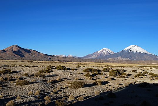
Parinacota and its neighbor, Pomerape, are also known as the Nevados de Payachata. This name means "twins." It refers to how similar the two volcanoes look.
Where is Parinacota Located?
Parinacota is on the western edge of the Altiplano, a high plateau in the Andes. The border between Bolivia and Chile goes right through the volcano. Most of the volcano is in Chile. It is in the Putre area of the Arica y Parinacota Region. In Bolivia, it's in the Oruro Department.
The towns of Ajata and Parinacota are located southwest and west of the volcano. This area is very high up and hard to reach. This makes it challenging for scientists to study the volcanoes here.
Volcanoes in the Andes

The Nazca Plate and Antarctic Plate are huge pieces of Earth's crust. They are slowly sliding (or subducting) under the South America Plate. This movement causes volcanoes to form in the Andes mountains.
There are four main groups of volcanoes in the Andes. Parinacota is part of the Central Volcanic Zone (CVZ). This zone has about 44 active volcanoes. Many of these volcanoes are very tall, over 5,000 meters (16,400 feet) high.
The Earth's crust is very thick in the CVZ. This affects how the magma (melted rock) forms and moves. Volcanic activity has been happening in this region for about 200 million years. Over time, the volcanoes have slowly moved westward. Today, they are located along the Bolivia-Chile border.
Parinacota's Shape and Rocks

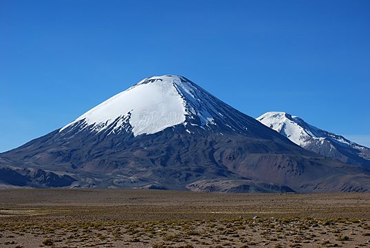
Parinacota has a very classic, symmetrical cone shape. It is 6,380 meters (20,932 feet) tall. The volcano has both chunky lava flows and scoria flows. Some lava flows are very fresh and can be up to 7 kilometers (4.3 miles) long. They can be 10 to 40 meters (33 to 131 feet) thick.
The top of the volcano has a large summit crater. It is about 1 kilometer (0.6 miles) wide and 300 meters (984 feet) deep. This crater looks very new and untouched. Pumice flows have come from this crater. They can reach up to 2 kilometers (1.2 miles) away. Ash from Parinacota has spread up to 15 kilometers (9.3 miles) to the east.
The main volcano sits on a thick platform of andesitic lava. This platform is called the "Chungará Andesites." On top of this platform are several lava domes. These domes can be up to 150 meters (492 feet) thick.
-
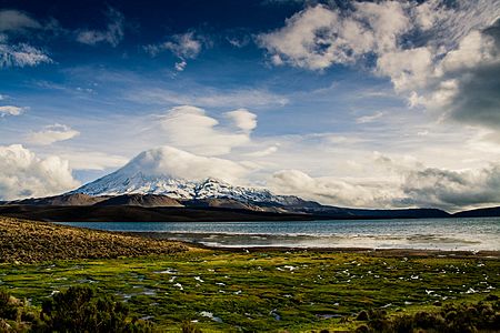
Parinacota volcano
-
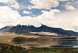
The white lava domes and a black lava flow are visible above the lake
-
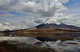
The domes at the foot of Parinacota are well visible. In the middle right of the image, one of the Ajata lava flows is recognizable
-
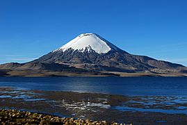
The grey lava domes and a black Ajata lava flow are clearly visible
-
A black lava flow almost reaches the lake


South of the main volcano are the Ajata cones. These are smaller, parasitic vents. They formed along a crack in the ground. These cones are up to 250 meters (820 feet) wide and 70 meters (230 feet) high. They have produced dark, chunky lava flows. The longest of these flows is about 3 kilometers (1.8 miles) long.
Older lava flows, called "Border Dacites," are on the southeast side of Parinacota. These are about 4 by 2 kilometers (2.5 by 1.2 miles) in size. In total, Parinacota rises 1,768 meters (5,800 feet) from its base. The entire volcano has a volume of about 40.6 cubic kilometers (9.7 cubic miles).
To the north, Parinacota partly overlaps with Pomerape. These two volcanoes, along with others to the south, form the eastern edge of the Lauca basin. This basin is a flat plain drained by the Rio Lauca.
Glaciers and Ice
Parinacota used to have much larger glaciers. You can still see traces of where these glaciers eroded the rocks. There are old piles of rock and dirt, called moraines, at 4,500 meters (14,764 feet) elevation. These were formed during a past ice age.

Today, a large ice cap covers the top of the volcano. It is about 4 to 12 square kilometers (1.5 to 4.6 square miles) in size. This ice cap reaches down to about 5,600 meters (18,373 feet) elevation. There is also a large glacier on the southern side.
However, the ice on Parinacota is shrinking. Between 1987 and 2016, the ice area decreased by almost 2% each year. Most of the remaining ice is on the western side of the mountain.
The Giant Collapse

Parinacota had a massive sector collapse. This means a huge part of its side broke off and slid away. This event removed about 5 to 6 cubic kilometers (1.2 to 1.4 cubic miles) of rock from the volcano. The landslide traveled 23 kilometers (14 miles) west. It covered an area of 110 to 253 square kilometers (42 to 98 square miles) with debris.
As the volcano grew, its weight pressed down on weaker rocks below. These rocks eventually gave way. Glaciers might have also weakened the western side of the volcano. The collapse was like a giant avalanche of rocks. It moved incredibly fast, perhaps 25 to 60 meters per second (56 to 134 miles per hour).
This collapse was similar to the one at Mount St. Helens in 1980. However, the Parinacota collapse was three times larger! Such collapses are common on volcanoes.

The avalanche created a unique landscape. It left behind many hills and bumps, called "hummocks." These hummocks can be up to 500 meters (1,640 feet) wide and 80 meters (262 feet) high. The avalanche deposit is mostly made of large blocks of rock.

The collapse also created Lake Chungará. The avalanche flowed across a river valley. It formed a 40-meter (131-foot) high natural dam. This dam held back about 0.4 cubic kilometers (0.1 cubic miles) of water, forming the lake.

Many other lakes and wet areas formed within the hummocky landslide deposit. These are known as the Lagunas Cotacotani. They are an important place for birds. Some of these lakes might be "kettle holes." These form when large blocks of ice, carried by the avalanche, melt.
These lakes eventually feed into the Rio Lauca. The river used to flow across the area now covered by the avalanche. The landslide material is very coarse, so water seeps through it instead of carving a new river channel. This means Lake Chungará has grown deeper and wider over time.
Scientists believe an eruption might have happened at the same time as the collapse. This is because pumice and lava bombs were found. However, the collapse itself was probably not caused by an eruption. After the collapse, the volcano quickly rebuilt its cone. Now, there is no sign of the huge scar left by the landslide.
Surrounding Areas
The area around Parinacota has many old volcanic rocks. Some of these are from volcanoes that were active millions of years ago. These include Caldera Ajoya, Caldera Lauca, and Condoriri.
Pomerape, northeast of Parinacota, looks similar but is older. It has more signs of erosion. Other older lava domes are found northwest and southwest of Parinacota.
Landforms from Ice and Water
The region around Parinacota has many periglacial landforms. These are shapes in the land created by freezing and thawing. They are common because the climate is dry, so large glaciers don't form easily. These landforms are found above 4,450 meters (14,600 feet) elevation.
Mudflows, called Lahars, have also happened at Parinacota. Thick layers of lahar deposits are found on the volcano's slopes. Some of these mudflows reached up to 15 kilometers (9.3 miles) away.
The volcanic rocks of Parinacota are well-preserved. This is because the climate is very dry, and the volcano is relatively young.
What is Parinacota Made Of?
The rocks erupted by Parinacota are made of different materials. They range from basaltic andesite to rhyolite. The older rocks are mostly hornblende and pyroxene andesites.
These rocks contain many different minerals. Some common ones include amphibole, biotite, feldspar, and olivine. Sometimes, pieces of other rocks, like gabbro and granite, are found inside the volcanic rocks.
The magmas (melted rock) that formed Parinacota came from deep within the Earth. They formed when fluids from the Nazca Plate (which is sliding under South America) mixed with hot material from the Earth's mantle. As these magmas rose, they interacted with the Earth's crust. This changed their chemical makeup.
Scientists have noticed a difference between the rocks erupted before and after the giant sector collapse. After the collapse, the erupted rocks became more "mafic." This means they contained more dark, heavy minerals. The collapse likely caused big changes in how magma moved and stored inside the volcano.
Climate Around Parinacota
.jpg)
The average temperature around Parinacota is about 2.5 to 6 degrees Celsius (36.5 to 43 degrees Fahrenheit). The freezing line is usually between 4,800 and 4,900 meters (15,748 and 16,076 feet) elevation. At higher altitudes, the air is thinner and drier. This means temperatures can change a lot between day and night, sometimes by 20 degrees Celsius (36 degrees Fahrenheit).
Parinacota gets about 440 millimeters (17 inches) of rain each year. Most of this moisture comes from the Amazon basin. It is carried by winds to the Andes. The region has a "puna seca" (dry puna) climate. Most rain falls during the summer months. This is when the Altiplano warms up, creating a monsoon-like wind. This summer rain is sometimes called the "Bolivian winter."
The climate is generally dry because of the South Pacific High pressure system. Also, the Andes create a rain shadow effect. The cold Humboldt Current in the Pacific Ocean also contributes to the dryness. This dry climate helps volcanoes stay recognizable for a long time. They are not eroded much by water.
The climate was not always so dry. There were wetter periods in the past, around 28,000 years ago and between 13,000 and 8,200 years ago. During these times, glaciers grew.
Flora and Fauna

The Andes mountains have many different climates. This means the plants and animals change depending on the location and height. Around Parinacota, between 3,400 and 4,600 meters (11,155 and 15,092 feet) altitude, you'll find shrub steppe plants. These include Baccharis incarum and Fabiana densa.
Above 4,000 meters (13,123 feet), grasses are common. On rocky ground, you might see cushion plants like Azorella compacta. These plants are bright yellow and can be seen from far away. This type of dry plant life is called "puna."
Polylepis tarapacana is the only true tree found at these high altitudes. It forms small woods, sometimes up to 5,100 meters (16,732 feet) high. Near water, you'll find bofedal marsh-like plants. Oxychloe andina is a common species there. Some plants are found only in the puna, like Chilotrichiops and Lampaya.
| Vegetation zone | Species |
|---|---|
| Wet sandy soils | Ephedra breana, Festuca, Pennisetum, Werneria glaberrima |
| Brackish and wet soils | Festuca orthophylla, Festuca scirpifolia, Poa |
| Wetlands and impermeable soils | Carex, Festuca scirphifolia, Oxychloe andina |
| Some species in the grass vegetation area | |
-
-
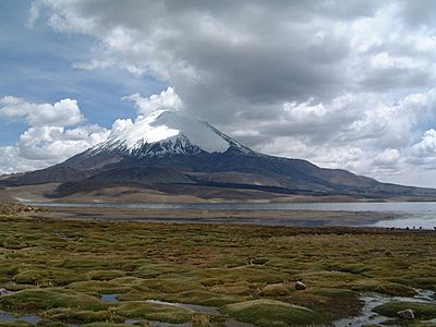
Vegetation at Lake Chungará; the summit of Parinacota is enveloped in a cloud


Many things affect the plants here. These include lack of water, salty soils, strong sunlight, wind, and cold nights. Pollen from these plants can be found in ice samples from Parinacota's icecap.
-
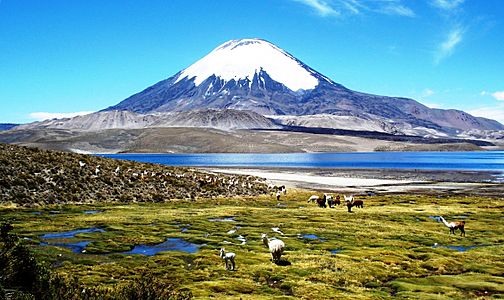
Animals in front of Lake Chungará
-
Animals in front of Lake Chungará


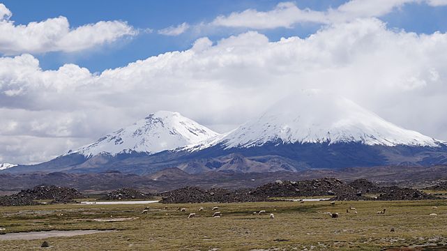
Animals living around Parinacota include flamingos, guanacos, vicuñas, and viscachas. Predators like the Andean cat, pampas cat, and puma also live here. Rodents are the most common animals. Birds like the rhea, tinamous, and the Andean condor are also important.
Many mammal populations were small in the past. But some have grown recently. In 1965, Parinacota and its surroundings became part of the Lauca National Park. This park protects the unique plants and animals. However, there are still threats to the environment. These include possible water diversions from Lake Chungará, hunting, and a major highway nearby.
Lake Chungará itself has its own plants and animals. These include different types of algae and aquatic plants. The lake is home to about 19 species of Orestias fish. Some of these fish are found nowhere else. The volcanic activity of Parinacota and its collapse helped new fish species form.
Parinacota's Eruptive History
Parinacota has had five different periods of volcanic activity. Scientists believe its last eruption was fairly recent. This is because the volcano's shape and lava flows look well-preserved. It is considered one of the most active volcanoes in the Central Andes. Magma might rise easily here because of cracks in the Earth's crust.
Early Stages: Chungará Andesites and Lava Domes

The oldest parts of Parinacota are the "Chungará Andesites" and the lava domes. These form a platform on the volcano's southern side, facing Lake Chungará. These rocks erupted between 300,000 and 100,000 years ago. There was a long break of over 60,000 years before the next stage of eruptions.
The Old Cone and the Big Collapse
While the lava domes were forming, the "Old Cone" of Parinacota began to grow. This happened northwest of the domes. The Old Cone grew for about 85,000 years. It is also known as Parinacota 2. Rocks from this stage are found on the lower slopes. Some of these rocks are 20,000 to 53,000 years old.
The "Border Dacites" also belong to this stage, dated around 28,000 years ago. Ash from this period has been found in the Cotacotani lakes. This shows that the Old Cone had explosive eruptions sometimes. During this time, glaciers also grew on the Old Cone.
The exact date of the giant sector collapse is not certain. Scientists have estimated it happened between 8,000 and 20,000 years ago. The most recent estimate is about 8,800 years ago. This period matches a time when many volcanoes around the world had collapses. Global warming might have made volcanoes more likely to collapse.
The Young Cone and Ajata Cones

After the huge collapse, the volcano quickly rebuilt itself. This stage is called the "Young Cone" or Parinacota 3. During this time, volcanic activity focused on the summit crater. The volcano grew to about 15 cubic kilometers (3.6 cubic miles) in size. Magma erupted much faster during this period.
Besides lava flows, there were also powerful explosive eruptions. Some of these happened around 4,800, 4,300, and 3,600 years ago. Ash from these eruptions fell into Lake Chungará. This ash added calcium to the lake water.
The Ajata cones also formed more recently. These cones are made of basaltic andesite. They have a volume of about 0.2 cubic kilometers (0.05 cubic miles). The Ajata cones formed in four different groups over time. The youngest Ajata flows are about 1,300 to 2,000 years old.
According to scientists, old Aymara stories might describe Parinacota's latest eruption. One story tells of a disaster that destroyed a town with fire. This story might refer to a small explosive eruption that sent a pyroclastic flow into Lake Chungará. This would have happened after the Spanish arrived.
Is Parinacota Still Active?
Today, Parinacota is a dormant volcano. This means it is not erupting, but it could erupt again in the future. Scientists have not seen clear fumarolic activity (gas vents). However, satellite images show slight temperature differences. Also, reports of sulfur smells at the summit suggest there might be a fumarole.
The volcano has some seismic activity (earthquakes). But it has fewer earthquakes than other volcanoes nearby. Scientists consider it a potentially active volcano.
The population density around the volcano is low. So, a new eruption might not cause much damage to people. However, the town of Sajama could be affected. The Arica-La Paz highway runs close to the volcano. It could be threatened by mudflows or debris flows. Small communities like Caquena, Chucullo, and Parinacota are also nearby.
Future hazards could include lahars (mudflows). These could form if magma mixes with the ice cap. Ashfall from eruptions could also harm pastures in the region. The important Lauca National Park could also be greatly affected by new eruptions.
Legends and History
People have lived in the area around Parinacota for about 7,000 to 10,000 years. About 1,000 years ago, the Tiwanaku and then the Inka empires ruled this region. Unlike many other mountains nearby, no ancient artifacts have been found on Parinacota's summit.
Many legends are told about Parinacota and its sister mountain, Pomerape. They are often shown as unmarried sisters. Some stories involve arguments with other mountains, like Tacora and Sajama. These stories often end with Tacora being driven away.
Gallery
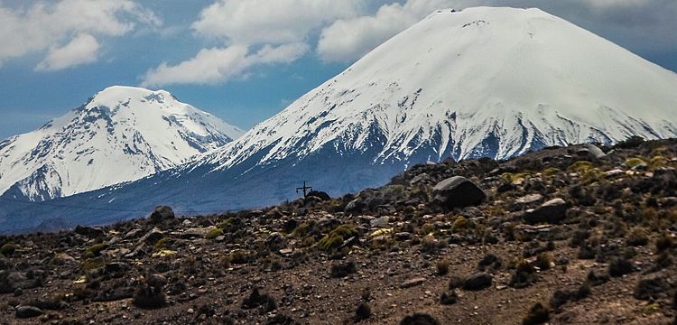
- Parinacota and Pomerape, the Nevados de Payachata
-
Parinacota on the right and Pomerape on the left
-
Parinacota and Pomerape
-
Parinacota on the right and Pomerape just right of the center
-
Parinacota, on the left Pomerape
-
Parinacota, on the left Pomerape


.jpg)


See also
 In Spanish: Volcán Parinacota para niños
- List of volcanoes in Bolivia
- List of volcanoes in Chile
