
Pothohar Plateau facts for kids
Quick facts for kids
Potohar Plateau
سطح مرتفع پوٹھوہار
|
|
|---|---|
 |
|
| Country | |
| Region | Punjab Province |
| District | Rawalpindi District, Islamabad Capital Territory , Chakwal District, Jhelum District |
| Area | |
| • Total | 22,254 km2 (8,592 sq mi) |
| Elevation | 350 to 575 m (1,150 to 1,900 ft) |
| Population
(2017)
|
|
| • Total | 17,464,763 |
| Languages | |
| • Spoken | Potohari, Punjabi, Urdu |
| Time zone | UTC+5 (PST) |
The Potohar Plateau (also spelled Pothohar or Potwar) is a large, flat area of land in northeastern Pakistan. It forms the northern part of the Punjab province. This plateau is next to Azad Kashmir on its west and Khyber Pakhtunkhwa on its south.
Long ago, this region was home to the ancient Soanian culture. We know this because scientists have found old fossils, tools, coins, and remains of archaeological sites here. These discoveries tell us a lot about the people who lived here thousands of years ago.
The main language spoken in the Potohar region is Pothwari. People also speak Punjabi, especially the Majhi dialect. Other local dialects include Dhani and Shahpuri. Many different groups of people live in Potohar. These include clans like the Dhanyal, Mughals (like Mirza, Chughtai, Baig, Barlas), Gujjars, Jatts, Mohyals, Qazi, Khatris, Abbasi, Awans, Bhattis, Hanjras, Janjuas, Satti, Tarkhans, Gakhar clans, Sudhans, and Sikhs.
Contents
Geography of Potohar
The Potohar Plateau has natural borders all around it. To the east, it is bordered by the Jhelum River. The Indus River forms its western border. In the north, you'll find the Kala Chitta Range and the Margalla Hills. To the south, the Salt Range separates Potohar from the Punjab Plain.
Rivers and Hills
The Kala Chitta Range stretches towards Rawalpindi in the east. Two important rivers, the Haro and Soan, flow across the plateau. They start in the eastern hills and flow towards the Indus River. The Salt Range runs from east to west in the south.
The Potohar Plateau includes parts of four districts: Jhelum, Chakwal, and Rawalpindi. The land here is not flat but has many ups and downs. The Kala Chitta Range mountains are usually between 450 and 900 meters high. They stretch for about 72 kilometers. The Soan River begins near Murree and flows into the Indus River near Kalabagh. Sakesar is the highest mountain in this area. Tilla Jogian in Jhelum District is the second highest peak.
Farming and Water
Many hills and rivers in Potohar are surrounded by deep, cut-out valleys called ravines. The streams here flow very deeply. This makes them not very useful for irrigation (watering crops). So, agriculture in Potohar mostly depends on rainfall. The area gets about 380 to 500 millimeters of rain each year. The northwest gets the most rain, while the southwest is much drier.
Farmers mainly grow wheat, barley, and sorghum. They also grow legumes (like beans or lentils). In more fertile areas near the Indus River, you can find onions, melons, and tobacco.
Wildlife and Natural Resources
The Potohar Plateau is home to various animals. You might see urial (a type of wild sheep), chinkara (a gazelle), chukar partridges, hares, mongooses, wild boars, and yellow-throated martens.
However, the area faces challenges. There isn't much rainfall, and there's a lot of deforestation (trees being cut down). Also, coal mining and the search for oil and gas are happening. These activities are causing the area to lose its plant life. Lakes like Uchali, Khabeki, Jhallar, and Kallar Kahar have become much smaller over time.
The plateau is very important for Pakistan's energy. It has major oil fields. The first ones were found at Khaur in 1915 and Dhuliān in 1935. Later, the Tut field was found in 1968, and Missa Keswal in 1992. Oil exploration continued in the 1990s. These oil fields are connected by pipelines to the Attock Refinery in Rawalpindi. A large new oil reserve was also found near Jhelum. The Ghauri X-1 oil well is expected to be one of the country's biggest oil producers.
Major Cities
Several important cities are located on the Potohar Plateau. These include the capital city of Islamabad and its twin city, Rawalpindi. Smaller cities like Chakwal, Jhelum, and Attock are also part of this region.
History of Potohar


The Potohar Plateau has a very long and rich history. It was home to the ancient Soanian culture. The famous Indus Valley civilization also thrived here between 2300 and 1800 BC. Some of the oldest Stone Age tools in the world have been found on this plateau. These tools date back an amazing 500,000 to 100,000 years! The simple stone tools found show how early humans lived and worked here during the Ice Age.
Around 3000 BC, small village communities started to grow in the area. This was an important step in the development of early civilization.
Ancient Cities and Forts
Many ancient ruins can be found across the Potohar countryside. These include the remains of the Shahi kingdom, which was destroyed by Mahmud of Ghazni in the 11th century. Also, parts of ancient Gandhara were destroyed by the Hunas (Indo-Hephthalites) in the 6th century.
Ancient Taxila is a very important historical site on the plateau. It is recognized as a UNESCO World Heritage Site. Taxila was a famous center for Hindu and Buddhist learning. It was connected to the Silk Road, a major trade route. Students from all over the world came to study at its great university. Taxila was ruled by the Persian Achaemenid Empire, then Alexander the Great, and later the Sassanians. It was a thriving city in Gandhara from the 1st to 5th centuries AD. Sadly, it was finally destroyed by the Hunas between 450 and 565 AD.
The city of Rawalpindi also has a long history. Evidence shows that a Buddhist center existed there at the same time as Taxila. This ancient city was also likely destroyed by the Hunas. Later, in 1493 AD, a Gakhar chief named Jhanda Khan rebuilt it. He named it Rawalpindi after a village called Rawal. Today, Rawalpindi is the twin city of Pakistan's capital, Islamabad.
Rohtas Fort is another UNESCO World Heritage site in Potohar. Sher Shah Suri built it in 1541. He wanted to control the Gakhars, who were loyal to the Mughal Emperor Humayun.
Rawat Fort is about 17 kilometers (11 miles) east of Rawalpindi. It is on the Grand Trunk Road that leads to Lahore. Inside the fort is the grave of Sultan Sarang Khan, a Gakhar Chief. He died in 1546 AD fighting against Sher Shah Suri's forces. If you climb the steps inside the tomb, you can see a wide view of the plateau and the Mankiala Stupa.
The remains of the Mankiala Stupa are about 32 kilometers (20 miles) southeast of Rawalpindi. This Buddhist stupa was built during the rule of Kanishka (128-151 AD). A legend says that Gautama Buddha sacrificed parts of his body here to feed seven hungry tiger cubs. In 1930, gold, silver, and copper coins were found in this stupa. A bronze box with ancient writings was also discovered.
Pharwala Fort is about 40 kilometers (25 miles) from Rawalpindi. The Gakhar ruler, Sultan Kai Gohar, built it in the 10th century. It was built on the ruins of an older Hindu Shahi Fort from the same century. The Gakhars ruled the Potohar region for about 850 years. Emperor Babur attacked this fort in 1519 AD.
Katasraj Temple
The Salt Range in Potohar has many Hindu temples. The most famous one is the Katasraj temple. It is about 25 kilometers (16 miles) from Chakwal. This temple is special for many reasons. Local Hindus left it when they moved to East Punjab in 1947. Many sacred Hindu stories are connected to it, some involving the god Shiva himself. It has always been a holy place for pilgrimages. Even today, Hindu worshippers come to the temple every year. They bathe in the sacred pool around which Katasraj is built.
Legend says that the five Pandava brothers, heroes of the ancient Sanskrit epic Mahabharata, stayed here for four years during their exile. While Katas Raj is not widely known, its two partly ruined temples from the Hindu Shahi period (650-950 AD) have been photographed often. Experts from the University of Peshawar and the Pakistan Heritage Society are studying and documenting these important historical buildings.
Other Interesting Facts
- The Potohar region gave its name to a car model. The Suzuki Jimny SJ-410 was called the Suzuki Potohar in Pakistan.
- The fossil skull of a very old ape, the Sivapithecus indicus, was found in the Potohar plateau.
Images for kids
-
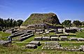
The Dharmarajika Stupa
-
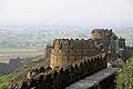
Rohtas Fort was built upon a hill overlooking the Pothohar Plateau.
-
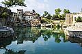
The complex consists of several temples and associated structures.


See also
 In Spanish: Meseta de Potwar para niños
