Dauphin County, Pennsylvania facts for kids
Quick facts for kids
Dauphin County
|
|||
|---|---|---|---|
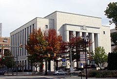
Dauphin County Courthouse in Harrisburg
|
|||
|
|||
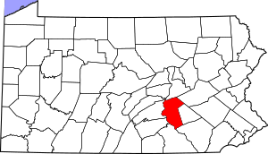
Location within the U.S. state of Pennsylvania
|
|||
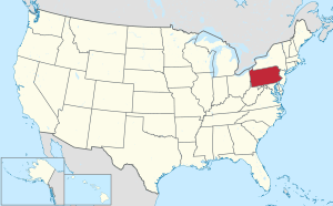 Pennsylvania's location within the U.S. |
|||
| Country | |||
| State | |||
| Founded | March 4, 1785 | ||
| Named for | Louis Joseph, Dauphin of France | ||
| Seat | Harrisburg | ||
| Largest township | Lower Paxton Township | ||
| Area | |||
| • Total | 558 sq mi (1,450 km2) | ||
| • Land | 525 sq mi (1,360 km2) | ||
| • Water | 33 sq mi (90 km2) 5.9%% | ||
| Population | |||
| • Estimate
(2023)
|
289,234 | ||
| Time zone | UTC−5 (Eastern) | ||
| • Summer (DST) | UTC−4 (EDT) | ||
| Congressional district | 10th | ||
|
Pennsylvania Historical Marker
|
|||
| Designated: | December 9, 1982 | ||
Dauphin County is a county in Pennsylvania, a state in the United States. It's like a big neighborhood or region within the state. As of 2020, about 286,401 people live here.
The main city and county seat is Harrisburg. This is also the capital city of Pennsylvania!
Dauphin County was created a long time ago, on March 4, 1785. It was named after Louis Joseph, Dauphin of France. He was the first son of King Louis XVI of France. The word "Dauphin" was a title for the oldest son of the King of France.
This county is part of the South Central Pennsylvania area. It's also part of a larger group of cities called the Harrisburg–Carlisle Metropolitan Statistical Area.
A famous place in the county was the Three Mile Island Nuclear Generating Station. This was a power plant that closed in 2019. It was known for a nuclear incident that happened there in 1979.
Contents
Geography of Dauphin County
Dauphin County covers about 558 square miles. Most of this area is land (525 square miles), and a smaller part is water (33 square miles).
The Susquehanna River forms most of the county's western border. This is a very large and important river in Pennsylvania.
Neighboring Counties
Dauphin County shares its borders with these other counties:
- Northumberland County (north)
- Schuylkill County (northeast)
- Lebanon County (east)
- Lancaster County (south)
- York County (southwest)
- Cumberland County (west)
- Perry County (west)
- Juniata County (northwest)
Main Roads and Highways
Many important roads pass through Dauphin County, connecting it to other parts of Pennsylvania and beyond. These include:

 I-76 / Penna Turnpike
 I-81
I-81 I-83
I-83 I-283
I-283
 US 11 / US 15
 US 22
US 22 US 209
 US 322
 US 422
 PA 25
PA 25 PA 39
PA 39 PA 147
 PA 225
 PA 230
 PA 283
 PA 325
 PA 341
 PA 441
 PA 443
 PA 743
 PA 849
 SR 3032
Climate and Weather
Dauphin County generally has a humid continental climate. This means it has warm, humid summers and cold winters. Some lower areas, like Harrisburg, might feel a bit more like a humid subtropical climate, which means slightly milder winters.
People and Population
| Historical population | |||
|---|---|---|---|
| Census | Pop. | %± | |
| 1790 | 18,155 | — | |
| 1800 | 22,270 | 22.7% | |
| 1810 | 31,883 | 43.2% | |
| 1820 | 21,653 | −32.1% | |
| 1830 | 25,243 | 16.6% | |
| 1840 | 30,118 | 19.3% | |
| 1850 | 35,754 | 18.7% | |
| 1860 | 46,756 | 30.8% | |
| 1870 | 60,740 | 29.9% | |
| 1880 | 76,148 | 25.4% | |
| 1890 | 96,977 | 27.4% | |
| 1900 | 114,443 | 18.0% | |
| 1910 | 136,152 | 19.0% | |
| 1920 | 153,116 | 12.5% | |
| 1930 | 165,231 | 7.9% | |
| 1940 | 177,410 | 7.4% | |
| 1950 | 197,784 | 11.5% | |
| 1960 | 220,255 | 11.4% | |
| 1970 | 223,834 | 1.6% | |
| 1980 | 232,317 | 3.8% | |
| 1990 | 237,813 | 2.4% | |
| 2000 | 251,805 | 5.9% | |
| 2010 | 268,100 | 6.5% | |
| 2020 | 286,401 | 6.8% | |
| 2023 (est.) | 289,234 | 7.9% | |
| U.S. Decennial Census 1790-1960 1900-1990 1990-2000 2010,< 2020 |
|||
In 2020, the county had 286,401 people. About 61% of the people were White, 17% Black or African American, and 6% Asian. About 11% of the population was of Hispanic or Latino background.
Amish Community
Dauphin County is home to an Amish community. These families live in the Lykens Valley, in the northern part of the county. They moved here from Lancaster County to find land that was less expensive.
2020 Census Details
| Race | Number | Percent |
|---|---|---|
| White (not Hispanic) | 175,175 | 61.16% |
| Black or African American (not Hispanic) | 48,404 | 17% |
| Native American (not Hispanic) | 396 | 0.14% |
| Asian (not Hispanic) | 17,183 | 6% |
| Pacific Islander (not Hispanic) | 88 | 0.03% |
| Other/Mixed (not Hispanic) | 13,904 | 4.85% |
| Hispanic or Latino | 31,251 | 11% |
Economy and Jobs
Many people in Dauphin County work for the government, since Harrisburg is the state capital. Other big employers include:
- The state government of Pennsylvania
- Milton S. Hershey Medical Center (a hospital)
- The Hershey Company (famous for chocolate!)
- Hershey Entertainment & Resorts Co. (theme parks and resorts)
- UPMC Pinnacle Hospitals
- The United States federal government
- Pennsylvania State University (a large university)
- PHEAA – Pennsylvania Higher Education Assistance Agency
- United Parcel Service Inc (UPS)
- TYCO Electronics Corp.
Fun and Recreation
Dauphin County has great places for outdoor fun! There are two Pennsylvania state parks where you can explore nature:
Education in Dauphin County
Dauphin County has many schools and colleges for students of all ages.
Colleges and Universities
If you want to go to college, here are some options in the county:
- Dixon University Center
- Harrisburg Area Community College
- Harrisburg University of Science and Technology
- Penn State Harrisburg
- Penn State Hershey Medical Center
- Temple University Harrisburg Campus
- Widener University School of Law
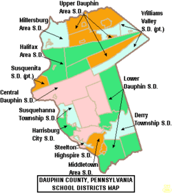
Public School Districts
Here are the public school districts that serve students in Dauphin County:
- Central Dauphin School District
- Derry Township School District
- Halifax Area School District
- Harrisburg School District (Pennsylvania)
- Lower Dauphin School District
- Middletown Area School District
- Millersburg School District
- Steelton-Highspire School District
- Susquehanna Township School District
- Susquenita School District (also in Perry County)
- Upper Dauphin School District
- Williams Valley School District (also in Schuylkill County)
Public Charter Schools
Dauphin County also has several public charter schools:
- Infinity Charter School
- Sylvan Heights Science Charter School
- Capital Area School for the Arts
- Premier Arts and Science Charter School
Library System
The Dauphin County Library System offers library services to everyone in the county. It has a main library in Harrisburg and eight other branch libraries. It's a great place to find books, learn new things, and use computers.
Communities in Dauphin County
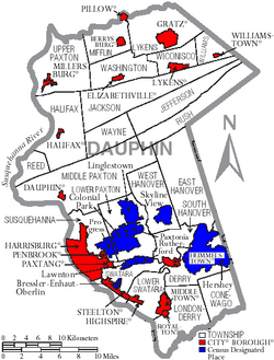
In Pennsylvania, there are different types of towns and areas. These include cities, boroughs, and townships. Here are the main communities in Dauphin County:
City
- Harrisburg (This is the county seat, where the county government is located.)
Boroughs
Boroughs are smaller towns with their own local governments.
- Berrysburg
- Dauphin
- Elizabethville
- Gratz
- Halifax
- Highspire
- Hummelstown
- Lykens
- Middletown
- Millersburg
- Paxtang
- Penbrook
- Pillow
- Royalton
- Steelton
- Williamstown
Townships
Townships are larger areas, often more rural, that also have their own local governments.
- Conewago
- Derry
- East Hanover
- Halifax
- Jackson
- Jefferson
- Londonderry
- Lower Paxton
- Lower Swatara
- Lykens
- Middle Paxton
- Mifflin
- Reed
- Rush
- South Hanover
- Susquehanna
- Swatara
- Upper Paxton
- Washington
- Wayne
- West Hanover
- Wiconisco
- Williams
Census-Designated Places (CDPs)
These are areas that the U.S. Census Bureau defines for collecting data, but they don't have their own separate local governments like cities or boroughs.
Unincorporated Communities
These are smaller places that are not officially part of a city, borough, or CDP.
- Bachmanville
- Cartin
- Chambers Hill
- Clifton
- Dietrich
- Deodate
- Dayton
- Carsonville
- Ebenezer
- Edgemont
- Ellendale Forge
- Enders
- Enterline
- Erdman
- Estherton
- Freys Grove
- Fort Hunter
- Grantville
- Greenfield
- Hanoverdale
- Heckton
- Hockersville
- Hoernerstown
- Inglenook
- Jednota
- Killinger
- Loyalton
- Lucknow
- Manada Gap
- Manada Hill
- Matamoras
- Matterstown
- Montrose Park
- Oakleigh
- Oakmont
- Oberlin Gardens
- Paxtang Manor
- Piketown
- Powells Valley
- Rockville
- Sand Beach
- Shellsville
- Singersville
- Speeceville
- Swatara
- Vaughn
- Waynesville
Population Ranking of Communities
This table shows the population of the largest communities in Dauphin County, based on the 2010 census.
† county seat
| Rank | City/Town/etc. | Municipal type | Population (2010 Census) |
|---|---|---|---|
| 1 | † Harrisburg (State Capital) | City | 49,528 |
| 2 | Hershey | CDP | 14,257 |
| 3 | Colonial Park | CDP | 13,229 |
| 4 | Progress | CDP | 9,765 |
| 5 | Middletown | Borough | 8,901 |
| 6 | Linglestown | CDP | 6,334 |
| 7 | Steelton | Borough | 5,990 |
| 8 | Paxtonia | CDP | 5,412 |
| 9 | Hummelstown | Borough | 4,538 |
| 10 | Rutherford | CDP | 4,303 |
| 11 | Skyline View | CDP | 4,003 |
| 12 | Lawnton | CDP | 3,813 |
| 13 | Penbrook | Borough | 3,008 |
| 14 | Millersburg | Borough | 2,557 |
| 15 | Highspire | Borough | 2,399 |
| 16 | Lykens | Borough | 1,799 |
| 17 | Paxtang | Borough | 1,561 |
| 18 | Elizabethville | Borough | 1,510 |
| 19 | Bressler | CDP | 1,437 |
| 20 | Williamstown | Borough | 1,387 |
| 21 | Palmdale | CDP | 1,308 |
| 22 | Enhaut | CDP | 1,007 |
| 23 | Wiconsico | CDP | 921 |
| 24 | Royalton | Borough | 907 |
| 25 | Halifax | Borough | 841 |
| 26 | Dauphin | Borough | 791 |
| 27 | Gratz | Borough | 765 |
| 28 | Oberlin | CDP | 588 |
| 29 | Lenkerville | CDP | 550 |
| 30 | Union Deposit | CDP | 407 |
| 31 | Berrysburg | Borough | 368 |
| 32 | Pillow | Borough | 298 |
Famous People from Dauphin County
Many interesting people have come from Dauphin County:
- Milton S. Hershey (1857–1945), who started The Hershey Company and built the town of Hershey.
- H.B. Reese (1879–1956), who invented the famous Reese's Peanut Butter Cups.
- Newt Gingrich (1943–), a well-known politician who used to be the Speaker of the U.S. House of Representatives. He was born in Harrisburg.
- Christian Pulisic (1998–), a famous soccer player who plays for Chelsea F.C. and the United States national team. He was born in Hershey.
- Micah Parsons (1999–), a professional football player.
- Michelle Wolf (1985–), a comedian.
Images for kids
See also
 In Spanish: Condado de Dauphin para niños


