Somerset County, Maryland facts for kids
Quick facts for kids
Somerset County
|
|||
|---|---|---|---|

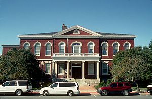
Somerset County Courthouse
|
|||
|
|||
| Motto(s):
"Semper Eadem" (English: "Ever the Same")
|
|||

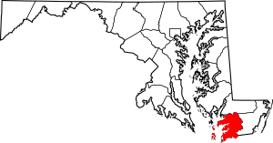
Location within the U.S. state of Maryland
|
|||
 Maryland's location within the U.S. |
|||
| Country | |||
| State | |||
| Founded | August 22, 1666 | ||
| Named for | Mary, Lady Somerset | ||
| Seat | Princess Anne | ||
| Largest town | Princess Anne | ||
| Area | |||
| • Total | 610.35 sq mi (1,580.8 km2) | ||
| • Land | 319.75 sq mi (828.1 km2) | ||
| • Water | 290.60 sq mi (752.7 km2) | ||
| Population
(2020)
|
|||
| • Total | 24,620 | ||
| • Density | 40.338/sq mi (15.574/km2) | ||
| Time zone | UTC−5 (Eastern) | ||
| • Summer (DST) | UTC−4 (EDT) | ||
| Congressional district | 1st | ||
Somerset County is a county in the state of Maryland, located at its southernmost tip. In 2020, about 24,620 people lived here, making it one of Maryland's smaller counties. Its main town and county seat is Princess Anne. The county is part of the "Lower Eastern Shore" area of Maryland.
Somerset County was named after Mary, Lady Somerset. She was the wife of Sir John Somerset. Her sister, Anne Calvert, later had Anne Arundel County named after her.
The University of Maryland Eastern Shore is located in Princess Anne. Somerset County is also part of the Salisbury, Maryland-Delaware metropolitan area.
Contents
A Look Back: Somerset County's History
Early Settlements and Quakers
Somerset County was first settled by English colonists. Many of these settlers were Quakers from Virginia. In the 1650s, Virginia made a law that Quakers had to become Anglican or leave the colony. Because of this, a group of Quakers asked Lord Baltimore, who governed Maryland, if they could move to the Eastern Shore of Maryland.
Lord Baltimore agreed in 1661. He saw this as a chance to strengthen Maryland's borders against Virginia. The Quakers settled near the Pocomoke River in 1662. Another group of Anglican settlers from Virginia also moved north to the Manokin River.
Lord Baltimore then set up a special group to oversee this new territory. This group helped create new settlements and keep records. This also helped Maryland claim the land more strongly.
A Border Dispute with Virginia
In 1663, Virginia tried to claim that its border with Maryland was much further north. A group of soldiers from Virginia, led by Colonel Edmund Scarborough, arrived in the Annemessex settlement. They tried to make the settlers promise loyalty to Virginia. They also wanted to arrest Stephen Horsey, a leader who spoke out against taxes.
Horsey refused to go with them, saying he was loyal to Maryland and Lord Baltimore. The settlers made Scarborough and his soldiers leave. The soldiers then went to the Manokin Settlement. Even though the Anglican settlers there were willing to promise loyalty to Virginia, they would not act against Lord Baltimore. Scarborough returned to Virginia without success.
First Leaders of the County
The new settlers created a government for Somerset County. It was the eighth county formed in the Province of Maryland. Stephen Horsey was chosen to be on the first county court in 1665. He and Captain William Thorne met with Charles Calvert, who officially made them county commissioners. Horsey was known for standing up for what he believed in.
Solving Border Problems
The county continued to have arguments about its borders, especially the northern one. Lord Baltimore thought his land went all the way to the top of the Delmarva Peninsula. But in the 1680s, William Penn, who founded Pennsylvania, claimed some of this land too. This led to a long legal fight between Penn and Baltimore.
They eventually agreed to divide the Delmarva Peninsula. However, they disagreed on exactly where the line should be drawn. Finally, in 1763, surveyors Charles Mason and Jeremiah Dixon drew the Transpeninsular Line. This line became the official border between Delaware and Maryland.
How the County Grew
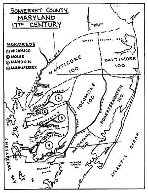
More and more settlers, mostly from Virginia, moved to the area. By 1666, there were enough people for the area to become an official county with its own local government. On August 22, 1666, Lord Baltimore officially created Somerset County. He set up a sheriff, a military leader, and surveyors to plan roads. In 1667, the county was divided into five main areas called "Hundreds." More Hundreds were added as the area was explored.
Different Faiths in the County
Settlement generally moved from the Chesapeake Bay eastward. The first settlers were Quakers and Anglicans, and more people of these faiths continued to arrive. In the 1670s, Presbyterians from Scotland and Ireland also began to move to the county.
In 1680, William Stevens, an Anglican, asked a Presbyterian group in Ireland to send a minister to Somerset County. Reverend Francis Makemie arrived in 1683. He was followed by other Irish Presbyterian ministers. Towns like Rehoboth and Snow Hill became important centers for Presbyterians. Their work eventually led to the start of American Presbyterianism in 1706.
In 1689, the "Glorious Revolution" in England changed who ruled. The Protestant rulers William and Mary took over from the Catholic King James II. This also led to a "Protestant Revolution" in Maryland. The Catholic government was overthrown, and Maryland became a Royal colony controlled by the king. The capital moved from St. Mary's City to Annapolis.
In 1692, the Maryland government made the Church of England the official church. This made things harder for Quakers and Presbyterians, who were not allowed to hold political office for a while. Their numbers in the county slowly went down until the American Revolution.
For over 100 years, the county grew with the help of enslaved Africans who worked on tobacco farms. Tobacco was a very important crop. But over time, tobacco farming wore out the soil. By the early 1800s, some farmers started growing different crops. The Eastern Shore remained mostly rural and had a society based on slavery.
A Link to Napoleon
There's a local legend that Napoleon I, the French emperor, almost came to Somerset County! After he was defeated in 1815, Napoleon wanted to escape to the United States. His brother, Jerome Bonaparte, had married an American woman from Baltimore. Through her, the Bonapartes had connections to important American families.
According to a 1944 book, a former mayor of New Orleans, Nicholas Girod, planned to rescue Napoleon from his exile in 1821. The plan was to hide Napoleon at Beverly House in Princess Anne, Somerset County. Then, he would be moved to Napoleon House in New Orleans. However, Napoleon died before the plan could happen.
Native American People
As English colonies grew, they took over land belonging to Native Americans. The coastal areas were home to tribes who spoke Algonquian languages. The number of Native Americans decreased because of diseases, wars, and changes to their way of life. Some tribes moved west or joined other tribes to the north.
However, some descendants of Maryland's tribes stayed. They married colonists, including white indentured servants and enslaved African and African-American people. Children of Native American mothers often grew up in their mother's culture. In recent times, many Native American groups have reorganized and gained recognition from the state.
New Counties Formed
After a war between the Dutch and English, the Dutch lost their colonies along the Delaware Bay. One of these became Durham County, Maryland, from 1665 to 1669. In 1669, it became part of Somerset County. Then, in 1683, it was given to William Penn.
Later, in 1742, Worcester County was formed from the eastern part of Somerset County. In 1867, parts of Somerset and Worcester counties were used to create a new county called Wicomico County.
Many historic places in Somerset County are listed on the National Register of Historic Places.
Somerset County's Geography
Somerset County covers about 610 square miles. About 320 square miles is land, and 291 square miles (48%) is water.
Neighboring Counties
Somerset County shares borders with:
- Wicomico County (to the north)
- Accomack County, Virginia (to the south)
- Dorchester County (to the northwest)
- Worcester County (to the east)
- Saint Mary's County (to the west)
Protected Natural Areas
The Deal Island Wildlife Management Area is a protected area in the northwest part of the county. It includes Deal Island and parts of the Chesapeake Bay. This area is about 13,000 acres and has over 9 miles of flat trails.
Climate and Weather
Somerset County has a humid subtropical climate. This means it has warm, humid summers and mild winters. The weather is usually above freezing all year.
| Climate data for Crisfield, Maryland | |||||||||||||
|---|---|---|---|---|---|---|---|---|---|---|---|---|---|
| Month | Jan | Feb | Mar | Apr | May | Jun | Jul | Aug | Sep | Oct | Nov | Dec | Year |
| Record high °F (°C) | 64 (18) |
69 (21) |
77 (25) |
87 (31) |
91 (33) |
92 (33) |
99 (37) |
98 (37) |
92 (33) |
90 (32) |
78 (26) |
71 (22) |
99 (37) |
| Mean daily maximum °F (°C) | 44 (7) |
47 (8) |
55 (13) |
65 (18) |
74 (23) |
82 (28) |
87 (31) |
85 (29) |
79 (26) |
69 (21) |
58 (14) |
49 (9) |
66 (19) |
| Mean daily minimum °F (°C) | 30 (−1) |
31 (−1) |
38 (3) |
48 (9) |
57 (14) |
66 (19) |
71 (22) |
71 (22) |
64 (18) |
53 (12) |
43 (6) |
34 (1) |
51 (10) |
| Record low °F (°C) | −1 (−18) |
3 (−16) |
10 (−12) |
27 (−3) |
38 (3) |
46 (8) |
51 (11) |
50 (10) |
45 (7) |
30 (−1) |
22 (−6) |
7 (−14) |
−1 (−18) |
| Average precipitation inches (mm) | 3.25 (83) |
3.00 (76) |
4.29 (109) |
2.81 (71) |
3.12 (79) |
2.83 (72) |
4.14 (105) |
4.15 (105) |
2.76 (70) |
2.78 (71) |
2.80 (71) |
2.51 (64) |
38.44 (976) |
| Source: Weather.com | |||||||||||||
People of Somerset County
| Historical population | |||
|---|---|---|---|
| Census | Pop. | %± | |
| 1790 | 15,310 | — | |
| 1800 | 17,358 | 13.4% | |
| 1810 | 17,195 | −0.9% | |
| 1820 | 19,579 | 13.9% | |
| 1830 | 20,166 | 3.0% | |
| 1840 | 19,508 | −3.3% | |
| 1850 | 22,456 | 15.1% | |
| 1860 | 24,992 | 11.3% | |
| 1870 | 18,190 | −27.2% | |
| 1880 | 21,668 | 19.1% | |
| 1890 | 24,155 | 11.5% | |
| 1900 | 25,923 | 7.3% | |
| 1910 | 26,455 | 2.1% | |
| 1920 | 24,602 | −7.0% | |
| 1930 | 23,382 | −5.0% | |
| 1940 | 20,965 | −10.3% | |
| 1950 | 20,745 | −1.0% | |
| 1960 | 19,623 | −5.4% | |
| 1970 | 18,924 | −3.6% | |
| 1980 | 19,188 | 1.4% | |
| 1990 | 23,440 | 22.2% | |
| 2000 | 24,747 | 5.6% | |
| 2010 | 26,470 | 7.0% | |
| 2020 | 24,620 | −7.0% | |
| 2023 (est.) | 24,910 | −5.9% | |
| U.S. Decennial Census 1790–1960 1900–1990 1990–2000 2010 2020 |
|||
Population in 2020
In 2020, the population of Somerset County was 24,620 people. Here's a quick look at the different groups living there:
| Race / Ethnicity | Pop 2010 | Pop 2020 | % 2010 | % 2020 |
|---|---|---|---|---|
| White alone (NH) | 13,796 | 12,886 | 52.12% | 52.34% |
| Black or African American alone (NH) | 11,082 | 9,449 | 41.87% | 38.38% |
| Native American or Alaska Native alone (NH) | 83 | 80 | 0.31% | 0.32% |
| Asian alone (NH) | 183 | 250 | 0.69% | 1.02% |
| Pacific Islander alone (NH) | 2 | 1 | 0.01% | 0.00% |
| Some Other Race alone (NH) | 46 | 69 | 0.17% | 0.28% |
| Mixed Race/Multi-Racial (NH) | 415 | 810 | 1.57% | 3.29% |
| Hispanic or Latino (any race) | 863 | 1,075 | 3.26% | 4.37% |
| Total | 26,470 | 24,620 | 100.00% | 100.00% |
Note: The US Census counts Hispanic/Latino people as an ethnic group. This table separates them from the main racial groups.
Population in 2010
In 2010, there were 26,470 people living in Somerset County. About 53.5% were white, and 42.3% were black or African American. About 3.3% of the population was of Hispanic or Latino background.
The average household had 2.37 people, and the average family had 2.91 people. The median age was 36.5 years.
The median income for a household was $42,443. For families, it was $49,759. About 18.6% of all people, and 27.0% of those under 18, lived below the poverty line.
Towns and Communities
City
Town
- Princess Anne (This is the county seat, meaning it's where the county government is located.)
Census-Designated Places (CDPs)
These are areas that the Census Bureau defines for gathering data, but they are not officially incorporated towns.
- Chance
- Dames Quarter
- Deal Island
- Eden
- Fairmount
- Frenchtown-Rumbly
- Mount Vernon (also known as Hog's Neck, Cow Island, or Jason)
- Smith Island
- West Pocomoke
Other Communities (Unincorporated)
These are smaller communities that are not officially part of a city or town.
See also
 In Spanish: Condado de Somerset (Maryland) para niños


