
Swan River (Western Australia) facts for kids
Quick facts for kids Swan River |
|
|---|---|

|
|

Map of the area around Perth, showing the location of the Swan River
|
|
| Native name | Noongar: Derbarl Yerrigan |
| Country | Australia |
| State | Western Australia |
| City | Perth; Fremantle |
| Physical characteristics | |
| River mouth | Indian Ocean Fremantle 0 m (0 ft) 32°4′25″S 115°42′52″E / 32.07361°S 115.71444°E |
| Length | 72 km (45 mi) |
| Basin features | |
| Basin size | 121,000 km2 (47,000 sq mi) |
| Tributaries |
|

The Swan River is a famous river in the southwest of Western Australia. Its name in the Noongar language is Derbarl Yerrigan. This river flows right through Perth, which is the capital and largest city of Western Australia.
Contents
What is the Swan River Like?
The Swan River is an estuary, which means it's where the river meets the sea. It flows through the city of Perth. The parts of the river closer to the ocean are wide and deep. Further upstream, the river becomes narrower and shallower.
Where Does the River Get Its Water?
The Swan River collects water from a huge area called a catchment. This area is about 121,000 square kilometres (47,000 sq mi) in total. The river has three main smaller rivers that flow into it: the Avon River, Canning River, and Helena River.
The Canning and Helena rivers have dams built on them. These dams, called Canning Dam and Mundaring Weir, store a lot of the drinking water for Perth. Most of the fresh water in the Swan River comes from the Avon River.
The area around the river has a Mediterranean climate. This means it has mild, wet winters and hot, dry summers. So, the amount of water flowing in the river changes a lot with the seasons.
How Does the River Flow?
The Avon River starts near Yealering, about 221 kilometres (137 mi) southeast of Perth. It winds its way north to Toodyay. Then, it turns southwest in Walyunga National Park. At this point, where the Wooroloo Brook joins it, the Avon River officially becomes the Swan River.
The Canning River begins near North Bannister, about 100 kilometres (62 mi) southeast of Perth. It meets the Swan River at Applecross, flowing into a wide area called Melville Water. The river then gets narrower at Blackwall Reach. From there, it flows through Fremantle Harbour and finally reaches the Indian Ocean.
The Dreamtime Story of the River
The Noongar people have a special belief about the Darling Scarp. They believe it is the body of a Wagyl, also known as Waugal. This is a snake-like being from their Dreamtime stories. The Wagyl is said to have moved across the land, creating all the rivers, waterways, and lakes. Many believe the Wagyl created the Swan River.
The river's mouth has small tides, usually rising and falling about 1 metre (3 ft 3 in). However, the water levels can also change due to air pressure.
How the River Has Changed Over Time
Long, long ago, before a time called the Tertiary period, the sea level was much lower. The Swan River used to curve north of Rottnest Island. It flowed into the Indian Ocean a bit north and west of Rottnest. As it flowed, it carved out a huge gorge, similar in size to the Grand Canyon. This underwater canyon is still there today, called Perth Canyon. It's located near the edge of the continental shelf.

The Swan River drains a large area called the Swan Coastal Plain. This area is over 100,000 square kilometres (39,000 sq mi). The region has a Mediterranean climate, with hot, dry summers and cool, wet winters. However, this weather pattern seems to be changing. The Swan River flows down from the Darling Scarp across the coastal plain to the ocean at Fremantle.
The river starts as the Avon River, which rises near Yealering in the Darling Range. This is about 175 kilometres (109 mi) from where it meets the ocean at Fremantle. The Avon flows north through towns like Brookton, Beverley, York, Northam, and Toodyay. Other rivers like the Dale River, the Mortlock River, and the Brockman River join it. The Avon becomes the Swan River when Wooroloo Brook flows into it near Walyunga National Park.
Smaller Rivers Joining the Swan
Many other smaller rivers, called tributaries, join the Swan River. These include Ellen Brook, Jane Brook, Henley Brook, Wandoo Creek, Bennett Brook, Blackadder Creek, Limestone Creek, Susannah Brook, and the Helena River. Most of these smaller rivers now dry up or only flow during certain seasons. This is because of human activities like clearing land and building new areas.
Wetlands and Islands

Between Perth and Guildford, the river makes several loops. In the past, areas like Maylands Peninsula, Ascot, and Burswood were swampy wetlands. These wetlands were north of the city, near Claise Brook and Herdsman Lake. Most of these wet areas have since been filled in for building. Heirisson Island, where The Causeway bridge crosses, used to be a group of small islands.
Perth Water and Melville Water
Perth Water is the part of the river between the city and South Perth. It's separated from the main estuary by a narrow section called The Narrows. The Narrows Bridge was built here in 1959. After The Narrows, the river opens up into a large area called Melville Water. The Canning River flows into the Swan River at Canning Bridge in Applecross. This is the widest part of the river, measuring over 4 kilometres (2.5 mi) from north to south. Point Walter has a long sand spit that sticks out up to 800 metres (2,600 ft) into the river, making boats go around it.
The River's End at Fremantle
The river narrows again between Chidley Point and Blackwall Reach. It curves around Point Roe and Preston Point before becoming the harbour. The Stirling Bridge and the Fremantle Traffic Bridge cross the river just north of its mouth. The Swan River finally flows into the Indian Ocean at Fremantle Harbour.
Animals and Plants of the Swan River
The Swan-Canning Estuary is home to many different kinds of plants and animals. Here are some of them:
- Fish: Over 130 types of fish live here, including bull sharks, rays, cobblers (also called Swan River catfish), herring, pilchards, bream, flatheads, leatherjackets, and blowfish.
- Jellyfish: You might see jellyfish like Phyllorhiza punctata and Aurelia aurita.
- Mammals: Bottlenose dolphins are often seen swimming in the river.
- Crabs and Prawns: There are prawns and blue manna crabs.
- Birds: Many birds live by the river, including the famous black swan, silver gulls, cormorants, twenty-eight parrots, rainbow lorikeets, kingfishers, red-tailed black cockatoos, Australian pelicans, Australian magpies, herons, and ducks.
History of the Swan River

The river was named Swarte Swaene-Revier (Black Swan River) by a Dutch explorer named Willem de Vlamingh in 1697. He named it after the many black swans he saw there. Vlamingh sailed a short way up the river, reaching about Heirisson Island.
Another expedition, led by French explorer Nicholas Baudin, also sailed up the river in 1801.
When the British settlement of Perth began in 1829, Governor Stirling wanted the name "Swan River" to only refer to the part of the river upstream of the Heirisson Islands. He called the wider parts, like Perth Water, "Melville Water."
Soon after Perth was founded, people started to change the river. They did this for several reasons:
- To stop floods in winter.
- To make it easier for boats to travel by making channels deeper.
- To remove swampy land where mosquitoes lived.
- To create more dry land for farms and buildings.
Perth's streets were often very sandy and muddy. Governor James Stirling reported in 1837 that there were hardly any proper roads. They had cleared some paths and built bridges over streams, but crossing the wider parts of the Swan River still needed ferries.
Parts of the river needed to be dredged, which means digging up the bottom. The dug-up material was then dumped onto muddy areas to raise the land nearby. In 1862, a very wet winter caused major floods. These floods were even worse because of all the land that had been filled in. The first special digging machine, called a bucket dredge, in Western Australia was named the Black Swan. It was used from 1872 to 1911 to dig channels and fill in land.

Changes to the River's Shape
Since European settlement in 1829, many parts of the river, especially around the city, have been reshaped:
- Claise Brook: This was a freshwater creek that drained lakes north of the city. For many years, it became polluted. Since the late 1980s, the area has been cleaned up and now has a nice inlet for boats.
- Point Fraser: This used to be a large point of land on the north side of the river. It was removed between 1921 and 1935 when land was filled in to make the riverbank straighter.
- The Esplanade: The northern riverbank used to be very close to the city. Houses on St Georges Terrace had gardens that went right to the water's edge. Now, the Esplanade is a road set back from the water.
- Heirisson Islands: These were once a group of small muddy islands. Today, it's one man-made island with deep channels on each side.
- Burswood: Early on, the river was too shallow for many boats to travel between Perth and Guildford. So, a canal was dug in 1831 to create Burswood Island. This made travel easier. More land was filled in here throughout the 1900s.
- Point Belches: This area, later called Mill Point in South Perth, was a sandy point with a deep bay. This bay was filled in and widened to become the South Perth peninsula, where the Narrows Bridge is now.
- Mounts Bay: This bay was made much smaller in the 1950s when the Narrows Bridge and roads were built. An elderly woman named Bessie Rischbieth famously protested this by standing in front of bulldozers in 1957. She stopped them for one day!
- Fremantle Harbour: The harbour was built in the 1890s. A limestone reef that blocked the river's mouth was removed. This changed how the river flowed, making it more affected by tides. At this time, the Helena River was also dammed to provide water for the Kalgoorlie Goldfields.
Protecting the River's Environment
In the past, the river was used to get rid of all sorts of waste. Even into the 1970s, local councils had rubbish dumps along the riverbanks. Factories also released waste into the river. Cleanup efforts are still happening in some areas to remove harmful substances that seep into the river.
In summer, sometimes there are too many algae growing in the river. This is called an algal bloom. It can kill fish and is caused by nutrients from farms and fertilisers washing into the river. Sometimes, spills of chemicals have also caused parts of the river to be closed for safety. Even with these challenges, the river is still in pretty good shape.
In 2010, the Western Australian government limited the amount of phosphorus in fertilisers. This was done to help protect the health of the Swan and Canning river system.
The Perth Water area, next to the City of Perth, is a popular spot for watching the annual Australia Day fireworks. Over 400,000 people gather on the riverbanks, in Kings Park, and on boats to watch the show.
Major Floods in History
Records of floods in the Swan River estuary go back to 1829. In July 1830, just a year after the colony started, the river rose 6 metres higher than normal. Many new settlers lost their belongings and animals. Other big floods happened in 1847 and 1860. The most recent flood was in 2017.
The biggest recorded flood was in July 1872. This was a very rare event, like a "100-year flood." At the Helena River, the 1872 flood was much higher than the 1862 flood. A newspaper report from July 26, 1872, said that the area around Perth looked like a huge lake. All the jetties were underwater, and roads to Fremantle were covered. People had to climb hills to get into Perth.


In July 1926, another big flood caused the Upper Swan Bridge to wash away. A part of the Fremantle Railway Bridge also collapsed. This happened just five minutes after a train full of schoolchildren had crossed it! Luckily, no one was hurt, but it caused big problems for trade for several months. The bridge was fixed and reopened in October 1926.
Who Looks After the River?
The Swan River Trust is a government group that helps protect and manage the Swan and Canning rivers. It was created in 1989 and works with community members, state, and local government groups. They meet regularly to give advice on how to develop and care for Perth's river system.
How People Use the Swan River
Getting Around on the River
In the early days of the Swan River Settlement, the river was the main way to travel between Perth and Fremantle. This continued until the government built a railway system connecting Fremantle, Perth, and Guildford.

Bridges Over the Swan River

There are currently 22 road and railway bridges that cross the Swan River. Here are some of them, starting from Fremantle and going upstream:
- Fremantle Railway Bridge, connecting North Fremantle to Fremantle.
- Fremantle Traffic Bridge, connecting North Fremantle to Fremantle.
- Stirling Bridge (Stirling Highway), connecting North Fremantle to East Fremantle.
- Narrows Bridge, connecting South Perth to Perth (for the Kwinana Freeway and Mandurah railway line). There are three separate Narrows Bridges.
- The Causeway (north and south parts), connecting Perth to Heirisson Island and then to South Perth.
- Matagarup Bridge, a pedestrian bridge connecting East Perth to Perth Stadium in Burswood.
- Goongoongup Bridge, connecting East Perth to Burswood (for the Armadale railway line).
- Windan Bridge, connecting East Perth to Burswood (Graham Farmer Freeway).
- Garratt Road Bridge, connecting Bayswater to Ascot (two bridges).
- Redcliffe Bridge, connecting Bayswater to Ascot (Tonkin Highway).
- Bassendean Bridge, connecting Bassendean to Guildford.
- Guildford Railway Bridge, connecting Bassendean to Guildford (for the Midland railway line).
- Barkers Bridge, connecting Guildford to Caversham.
- Whiteman Bridge, connecting Caversham to Middle Swan (Reid Highway and Roe Highway).
- Maali Bridge, a pedestrian bridge connecting Henley Brook to Herne Hill.
- Yagan Bridge, connecting Belhus to Upper Swan (Great Northern Highway).
- Upper Swan railway bridge, Upper Swan.
- Bells Rapids bridge, connecting Upper Swan to Brigadoon.
.jpg)
Boating and Sports
The Swan River is a popular place for water sports.
- Rowing Clubs: Some of the earliest clubs were the West Australian Rowing Club and the Swan River Rowing Club, which started in 1887.
- Yacht Clubs: There are fifteen yacht clubs along the Swan River. Most are on Melville Water, Freshwater Bay, and Matilda Bay. The Royal Perth Yacht Club, located on Pelican Point, hosted the 1987 America's Cup sailing race. This was the first time in 132 years the race was held outside the United States.
The River's Importance to Perth
The Swan River is a very important part of Perth's culture. Many water sports like rowing, sailing, and swimming happen on its waters.
It is also the location for the City of Perth Skyworks, a large fireworks show held every year on Australia Day.
Images for kids
-
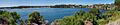
Panorama of Rocky Bay looking south
See also
 In Spanish: Río Swan para niños
