Taney County, Missouri facts for kids
Quick facts for kids
Taney County
|
||
|---|---|---|

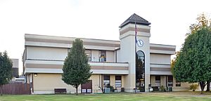
The Taney County Courthouse in Forsyth
|
||
|
||

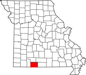
Location within the U.S. state of Missouri
|
||
 Missouri's location within the U.S. |
||
| Country | ||
| State | ||
| Founded | January 4, 1837 | |
| Named for | Roger B. Taney | |
| Seat | Forsyth | |
| Largest city | Branson | |
| Area | ||
| • Total | 652 sq mi (1,690 km2) | |
| • Land | 632 sq mi (1,640 km2) | |
| • Water | 19 sq mi (50 km2) 2.9% | |
| Population
(2020)
|
||
| • Total | 56,066 | |
| • Density | 85.99/sq mi (33.201/km2) | |
| Time zone | UTC−6 (Central) | |
| • Summer (DST) | UTC−5 (CDT) | |
| Congressional district | 7th | |
Taney County is a county located in the southwestern part of Missouri, a U.S. state. In 2020, about 56,066 people lived there. The main town, or county seat, is Forsyth. Taney County is also part of the Branson Micropolitan Statistical Area, which means it's connected to the larger city of Branson.
Taney County was officially started on January 4, 1837. It was named after Roger Brooke Taney. He was the fifth Chief Justice of the U.S. Supreme Court. He is known for a very important court case called Dred Scott v. Sandford. Even though his name is pronounced /ˈtɔːni/, people usually say /ˈteɪni/ when talking about Taney County.
The county is a popular place for tourists. It includes famous spots like Branson and beautiful lakes such as Table Rock, Taneycomo, and Bull Shoals.
Contents
History of Taney County
The very first courthouse in Taney County was built in 1837. It was located near Bull Creek and the White River. This building was used until Forsyth became the county seat. Sadly, a tornado destroyed it in 1963.
The second courthouse, located in Forsyth, was destroyed during a Civil War battle on July 22, 1861. A new courthouse was built, but it burned down on December 19, 1885.
A third courthouse had to be moved in 1952. This was to make way for the building of Bull Shoals Lake. The fourth and current courthouse opened on August 1, 1952. An addition was completed in 1991 after two years of construction.
In 2008, a new building called the Taney County Judicial Center was built. This center holds the courtrooms, the Circuit Clerk's office, and the County Jail.
Geography of Taney County
Taney County covers a total area of 652 square miles. About 632 square miles of this is land. The remaining 19 square miles (2.9%) is water.
The White River and its smaller rivers and streams flow through the county.
Neighboring Counties
- Christian County (north)
- Douglas County (northeast)
- Ozark County (east)
- Marion County, Arkansas (southeast)
- Boone County, Arkansas (south)
- Carroll County, Arkansas (southwest)
- Stone County (west)
Main Roads
 U.S. Route 65
 U.S. Route 160
 Route 76
 Route 86
 Route 125
 Route 165
 Route 176
 Route 248
 Route 265
 Route 376
 Route 465 (this road is now part of MO-76)
Public Transportation
- Jefferson Lines
Protected Natural Areas
- Mark Twain National Forest (part of it is in Taney County)
People of Taney County
| Historical population | |||
|---|---|---|---|
| Census | Pop. | %± | |
| 1840 | 3,264 | — | |
| 1850 | 4,373 | 34.0% | |
| 1860 | 3,576 | −18.2% | |
| 1870 | 4,347 | 21.6% | |
| 1880 | 5,599 | 28.8% | |
| 1890 | 7,973 | 42.4% | |
| 1900 | 10,812 | 35.6% | |
| 1910 | 9,287 | −14.1% | |
| 1920 | 8,878 | −4.4% | |
| 1930 | 8,867 | −0.1% | |
| 1940 | 10,323 | 16.4% | |
| 1950 | 9,863 | −4.5% | |
| 1960 | 10,238 | 3.8% | |
| 1970 | 13,023 | 27.2% | |
| 1980 | 20,467 | 57.2% | |
| 1990 | 25,561 | 24.9% | |
| 2000 | 39,703 | 55.3% | |
| 2010 | 51,675 | 30.2% | |
| 2020 | 56,066 | 8.5% | |
| U.S. Decennial Census 1790-1960 1900-1990 1990-2000 2010-2015 |
|||
In 2000, there were 39,703 people living in Taney County. The population density was about 24 people per square kilometer. Most people (96.22%) were White. About 2.42% of the population was Hispanic or Latino.
The average age of people in the county was 39 years old. About 22.40% of the population was under 18 years old.
Religions in Taney County
Many people in Taney County are Protestant Christians. The most common groups are Southern Baptists, Roman Catholics, and Presbyterians.
2020 Census Information
| Race | Num. | Perc. |
|---|---|---|
| White (not Hispanic) | 46,468 | 83% |
| Black or African American (not Hispanic) | 837 | 1.5% |
| Native American (not Hispanic) | 407 | 0.73% |
| Asian (not Hispanic) | 608 | 1.1% |
| Pacific Islander (not Hispanic) | 187 | 0.33% |
| Other/Mixed (not Hispanic) | 3,230 | 5.76% |
| Hispanic or Latino | 4,239 | 7.56% |
Education in Taney County
Most adults in Taney County (81.4%) have a high school diploma or higher. About 14.9% have a bachelor's degree or higher.
Colleges and Universities
- Ozarks Technical Community College, Hollister
- College of the Ozarks, Point Lookout
Public Schools
- Bradleyville R-I School District - Bradleyville
- Bradleyville Elementary School (Grades PK-6)
- Bradleyville High School (Grades 7-12)
- Branson R-IV School District - Branson
- Branson Primary School (Preschool)
- Branson Buchanan Elementary (Grades K-4)
- Branson Cedar Ridge Elementary (Grades K-4)
- Branson Buchanan Intermediate (Grades 4-6)
- Branson Cedar Ridge Intermediate (Grades 4-6)
- Branson Jr. High School (Grades 7-8)
- Branson High School (Grades 9-12)
- Forsyth R-III School District - Forsyth
- Forsyth Elementary School (Grades K-4)
- Forsyth Middle School (Grades 5-8)
- Forsyth High School (Grades 9-12)
- Hollister R-V School District - Hollister
- Hollister Elementary School (Grades PK-4)
- Hollister Middle School (Grades 5-6)
- Riedgedale Elementary School
- Hollister Jr. High School (Grades 7-8)
- Hollister High School (Grades 9-12)
- Kirbyville R-VI School District - Kirbyville
- Kirbyville Elementary School (Grades K-3)
- Kirbyville Middle School (Grades 4-8)
- Mark Twain R-VIII School District - Rueter
- Mark Twain Elementary School (Grades K-8)
- Taneyville R-II School District - Taneyville
- Taneyville Elementary School (Grades K-8)
Private Schools
- Link Academy - Scott Township (near Branson)
- Trinity Christian Academy - Hollister (Preschool-12) - A Christian school
- Riverview Bible Baptist Church School - Forsyth (Grades 5-8) - A Baptist school
- School of the Ozarks - Point Lookout
Libraries
- Forsyth Public Library
- Library Center of the Ozarks
Towns and Communities
Cities
- Branson (the biggest city, a small part is in Stone County)
- Forsyth (the county seat)
- Hollister
- Merriam Woods
- Rockaway Beach
Villages
- Bull Creek
- Kirbyville
- Saddlebrooke (mostly in Christian County)
- Taneyville
Census-Designated Place
Other Communities (Unincorporated)
See also
 In Spanish: Condado de Taney para niños
 | Selma Burke |
 | Pauline Powell Burns |
 | Frederick J. Brown |
 | Robert Blackburn |


