Tropical Storm Bonnie (2010) facts for kids
| Tropical storm (SSHWS/NWS) | |
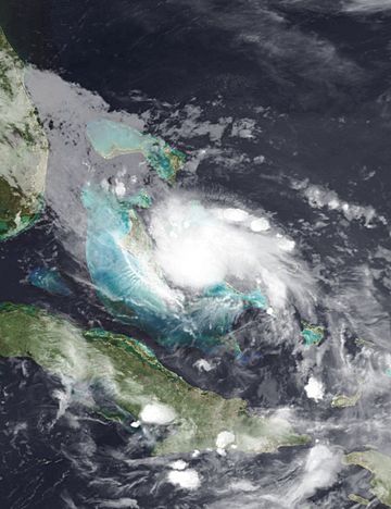
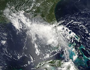
Tropical Storm Bonnie near peak intensity over the Bahamas on July 23
|
|
| Formed | July 22, 2010 |
|---|---|
| Dissipated | July 25, 2010 |
| (Remnant low after July 24) | |
| Highest winds | 1-minute sustained: 45 mph (75 km/h) |
| Lowest pressure | 1005 mbar (hPa); 29.68 inHg |
| Fatalities | 1 total |
| Damage | $1.36 million (2010 USD) |
| Areas affected | Puerto Rico, Hispaniola, Turks and Caicos, Bahamas, Florida |
| Part of the 2010 Atlantic hurricane season | |
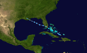
Tropical Storm Bonnie was a small and not very strong tropical storm. It brought stormy weather to the northern Caribbean Sea and the Gulf Coast of the United States in July 2010. Bonnie was the third tropical storm and second named storm of the 2010 Atlantic hurricane season. It started as a tropical wave over the Bahamas on July 22.
The storm grew stronger as it moved across the islands. It then made landfall on the southeastern coast of Florida the next day. Once inland, Bonnie became weaker and turned into a tropical depression. It then moved into the Gulf of Mexico, where it completely faded away on July 24. What was left of the storm reached land between Louisiana and Mississippi on July 25. This caused warnings for severe thunderstorms and even tornadoes in the area.
Before Bonnie became a storm, it caused a lot of rain in the Greater Antilles. This led to some flooding. In the Dominican Republic, hundreds of people had to leave their homes. Several bridges also fell apart because of the rushing water. One person drowned in Puerto Rico after being swept away by a swollen river. Other places like Haiti, the Bahamas, and Florida had lighter rain. The leftover parts of Bonnie caused more serious effects. There was heavier rain and stronger winds near the Gulf Coast, especially in Louisiana. The total damage from Bonnie and its remnants was about $1.36 million in 2010.
Contents
How Tropical Storm Bonnie Formed and Moved
On July 10, a weather system called a tropical wave moved off the coast of Africa. It traveled west over the Atlantic Ocean for several days. At first, it only brought weak showers. Weather experts did not think it would grow into a strong storm. Even though the winds high up in the atmosphere were not perfect, the system slowly started to develop by July 19. The air pressure at the surface began to drop.
The wave moved along the northeastern Caribbean. There, thunderstorms grew and faded because of changing winds and brief contact with land in Hispaniola. By July 22, thunderstorms returned over the Bahamas. A clear area of low pressure formed between the islands of Acklins and Great Inagua. Satellites showed a closed wind pattern. This led the National Hurricane Center (NHC) to announce that Tropical Depression Three had formed around 3 PM UTC. However, later studies showed it had formed nine hours earlier.
When it formed, the depression was expected to move west-northwest. This was because of a strong high-pressure area nearby. Later that day, the lowest pressure dropped to 1006 millibars. Satellite images showed good airflow moving away from the storm. This helps storms grow. Even though its cloud pattern was still messy, a special reconnaissance aircraft flew into the storm. It found that the winds had gotten stronger. So, it was upgraded to Tropical Storm Bonnie. This happened southeast of Nassau, Bahamas, about five hours after the NHC first started tracking it.
Around 9 PM UTC, Bonnie passed over Ragged Island in the Bahamas. Its winds were about 40 mph (65 km/h). Soon after, it reached its strongest point with winds of 45 mph (75 km/h). The next day, conditions high up in the atmosphere became less favorable. So, the storm did not get much stronger as it sped towards Florida. Even though it had tropical storm-force winds, they were only in a few rainbands to the north and east of the center. The strongest thunderstorms were over southeast Florida.
On July 23 at 2:30 PM UTC, Bonnie's center made landfall near Elliott Key with winds of 40 mph (65 km/h). Moving over land made the storm fall apart even more. Its thunderstorms quickly faded. Another reconnaissance flight confirmed that the winds were not very strong. Experts believe the storm lost its tropical storm strength around 6 PM UTC that same day.
On the morning of July 24, strong thunderstorms briefly returned over the center as Bonnie moved into the Gulf of Mexico. But after this, the storm moved into an area with very strong winds high up. These winds quickly blew away the thunderstorms. Bonnie then became just a tight swirl of low clouds. There were only a few small patches of strong thunderstorms left. Later satellite images showed Bonnie no longer had a clear storm structure. The NHC announced that the system had faded away. It was about 100 miles (160 km) from the mouth of the Mississippi River. What was left of Bonnie drifted west-northwest. It finally disappeared over southeast Louisiana on July 25.
Preparing for Tropical Storm Bonnie
When the NHC first started tracking Bonnie, they issued a tropical storm warning for the central and northwest islands of the Bahamas. In Florida, a tropical storm watch was put in place. This covered the area from Golden Beach north to Jupiter Inlet, and included Lake Okeechobee. Also, a tropical storm warning was issued from Golden Beach to Bonita Springs on Florida's west coast. This included the Florida Keys and Florida Bay.
By early July 23, the tropical storm warning from Golden Beach to Bonita Springs was canceled. A new tropical storm warning was issued from Englewood to Deerfield Beach, Florida. Six hours later, a tropical storm watch was put into effect from Destin, Florida to Morgan City, Louisiana. This was later upgraded to a tropical storm warning. Three hours after that, the tropical storm watch from Deerfield Beach to Jupiter Inlet, Florida, was canceled. All tropical storm warnings in the Bahamas were also stopped. By 3 PM UTC on July 24, all tropical storm watches and warnings had been canceled. This was shortly before Bonnie completely faded away.
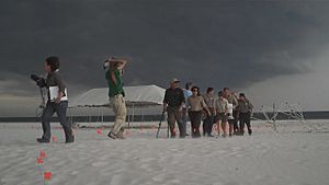
Three cruise ships had to change their routes because of Bonnie. These ships were the Carnival Pride, Carnival Destiny, and Grandeur of the Seas. Because of the storm threat, Louisiana Governor Bobby Jindal declared a state of emergency on July 22. Along the Gulf Coast, people were worried about how the storm might affect the Deepwater Horizon oil spill that happened earlier that year. Authorities prepared for possible evacuations of low-lying coastal areas. This was because of the risk of storm surge carrying oil. On July 23, Admiral Thad Allen ordered the oil spill site to be evacuated. Bonnie was a safety threat to nearly 2,000 people working there. Ships and vessels in the area started getting ready to leave on July 24. Closer to shore, about 1,300 fishing boats that were laying oil booms also had to evacuate.
Impact of Tropical Storm Bonnie
Caribbean Islands
The weather system that became Bonnie brought a lot of rain to parts of Puerto Rico and Hispaniola. This caused widespread flooding. In Puerto Rico, one person drowned after being caught in a swollen river. About 1,500 people in the Dominican Republic needed to be evacuated. Officials in the Dominican Republic said the system brought more than 4 inches (100 mm) of rain. Several towns in the country were cut off after bridges collapsed. Some light flooding also happened in Artibonite, Haiti, but no damage was reported there.
As Bonnie moved through the Bahamas, people bought extra food and water as a safety step. However, no big preparations were made. Most businesses stayed open during the storm's passage. Schools were already closed for the summer break. Overall, Bonnie's effects on the islands were quite small. Heavy rain fell on a few islands, and there was a lot of lightning. No known damage or deaths happened.
United States
Bonnie was a weak and disorganized storm when it hit Florida. So, its effects there were minimal. Strong winds damaged newly planted trees, and some power lines fell. About 14,000 people across the state lost power. A storm surge of 0.94 feet (0.29 meters) was measured at Virginia Key. Tropical storm-force winds were recorded in several places. However, sustained winds over 40 mph (65 km/h) were only found at Virginia Key. Rainfall was also light, with a maximum of 3.25 inches (83 mm) falling in northern Miami-Dade County. In total, the money lost from the storm in Florida was about $2,000 in 2010. In Pinellas County, one person was taken to the hospital after being hit by lightning at Fred Howard Park on July 24.
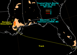
On July 25, the remnants of Bonnie brought very heavy rain to parts of Louisiana. In just 90 minutes, between 8 and 9 inches (200 and 230 mm) of rain fell in West Baton Rouge Parish. About 110 homes in the parish were flooded. This caused about $500,000 in losses in 2010. Along Highway 15, 2 feet (0.61 meters) of water covered the road. In Washington Parish, more than 20 bridges and roads were washed out by flash flooding. The losses there were about $200,000 in 2010.
Strong thunderstorms with the system also brought powerful winds. These winds were estimated up to 69 mph (111 km/h). They knocked down several trees, causing $6,000 in losses in 2010. A second day of severe weather on July 26 brought very strong wind gusts to parts of Vernon Parish. Two chicken houses were destroyed by the winds, killing 22,000 chickens. Losses from these winds were estimated at $310,000 in 2010. After moving through Louisiana, Bonnie's remnants brought heavy rain to parts of Texas. In Hidalgo County, U.S. Route 69 was reportedly covered with high water.
Further inland, moisture from Bonnie mixed with a cold front. This created widespread thunderstorms over Arkansas, Mississippi, and Tennessee. In Arkansas, lightning from a severe thunderstorm knocked out power to much of the city of Rison. This happened after it struck a power transformer. Significant wind damage occurred in Dallas County. Awnings were blown off homes, roofs were damaged, and trees were knocked down. Heavy rains also caused local flash flooding, covering several highways. Across the state, storm damage was estimated at $344,000 in 2010.
See also
 In Spanish: Tormenta tropical Bonnie (2010) para niños


