
Waterfront Trail facts for kids
Quick facts for kids Waterfront Trail |
|
|---|---|

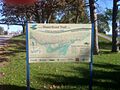
A sign demarcating The Waterfront Trail in Toronto
|
|
| Length | 3,600 km (2,200 mi) |
| Location | Ontario, Canada |
| Trailheads | Niagara-on-the-Lake, Quebec border (near Cornwall, Ontario) |
| Use | Biking, hiking, inline skating |

The Great Lakes Waterfront Trail is a super long path for walking, biking, and exploring. It stretches over 3600 kilometers (that's about 2236 miles!) across Ontario, Canada. This amazing trail connects more than 150 towns and First Nations communities. It follows the shores of the Great Lakes and the St. Lawrence River.
The trail helps us celebrate nature and different cultures. It's also part of a bigger plan to protect the world's largest group of freshwater lakes. The Waterfront Regeneration Trust, a charity, helped create this trail with local partners. In Toronto, a part of the trail is called the Martin Goodman Trail. Many people also use the Waterfront Trail to get to work or school in Southern Ontario.
Contents
Trail Expansion and Future Plans
In October 2013, Kathleen Wynne, who was the Premier of Ontario at the time, announced that the government would help make the trail even bigger. This was to better connect places used for the 2015 Pan Am Games.
She said she wanted everyone in Ontario to benefit from the money spent on the Games. Extending the trail system was a great way for the excitement of the Games to last long after 2015.
The government also promised to work with First Nation and Métis communities. They planned to add special markers along the trails. These markers would honor the history and culture of Indigenous communities in Ontario.
The trail would connect to four main Pan Am and Parapan Am Games places. These included the Athletes' Village and different sports parks. All plans for the Pan Am trails also had to make sure they were easy for everyone to use, including people with disabilities.
In November 2013, two design companies were chosen to rethink the old Ontario Place area in Toronto. Their goal was to create more green spaces and parks there.
Since 2013, the trail has grown a lot! New parts have been added along Lake Erie, Lake Huron, and Georgian Bay. This has added over 2000 kilometers to its total length.
What You Can Do on the Trail
The Waterfront Trail is used for many fun activities. It's a great place to get outside and be active!
- Walking and Hiking
- Running
- Cycling
- Inline skating
- Skateboarding
- Using Mobility scooters
- Mountain biking
Cities Along the Trail
The Great Lakes Waterfront Trail connects many different cities and First Nations communities. Here's a list of some of them:
| St. Lawrence River | Lake Ontario | Lake Erie & Lake St. Clair | Lake Huron | Georgian Bay | Lake Huron (North Channel) |
|---|---|---|---|---|---|
| South Glengarry | Loyalist | Niagara-on-the-Lake | Plympton-Wyoming | Northern Bruce Peninsula
(Tobermory, Lion's Head) |
Greater Sudbury |
| Cornwall | Greater Napanee | Niagara Falls | Kettle & Stoney Point
First Nation |
South Bruce Peninsula
(Wiarton) |
Nairn and Hyman |
| South Dundas | Deseronto | Fort Erie | Lambton Shores
(Grand Bend) |
Georgian Bluffs | Baldwin |
| South Stormont | Belleville | Port Colborne | South Huron | Owen Sound | Espanola |
| Prescott | Quinte West | Haldimand County
(Dunnville, Nanticoke) |
Bluewater (GAP) | Meaford | NEMI (Little Current) |
| Augusta | Prince Edward County
(Picton, Carrying Place) |
Norfolk County | Central Huron | The Blue Mountains
(Thornbury, Blue Mountain Village) |
Sheguiandah |
| Brockville | Brighton | Elgin County
(Port Burwell, Port Stanley) |
Goderich | Collingwood | Assiginack (Manitouwaning) |
| Gananoque | Cramahe / Colborne | Chatham-Kent South
(Erieau, Rondeau Park) |
Ashfield-Colborne-Wawanosh
(Amberley) |
Wasaga Beach | Sables-Spanish Rivers |
| Frontenac Islands
(Wolfe Island and Howe Island) |
Alnwick/Haldimand | Leamington | Huron-Kinloss
(Lucknow, Ripley) |
Township of Tiny | Spanish |
| Kingston | Cobourg | Kingsville | Kincardine | Penetanguishene | Serpent River First Nation |
| Port Hope | Pelee Island | Saugeen Shores
(Port Elgin, Southampton) |
Midland | Township of the North Shore | |
| Clarington | Colchester | Saugeen Ojibway Nation | Tay Township
(Waubaushene) |
Blind River | |
| Oshawa | Amherstburg | South Bruce Peninsula
(Sauble Beach) |
Severn Township
(Port Severn, Severn Bridge) |
Huron Shores
(Iron Bridge) |
|
| Whitby | LaSalle | Northern Bruce Peninsula | Orillia | Thessalon | |
| Ajax | Windsor | Manitoulin Island | Gravenhurst | Plummer Additional | |
| Pickering | Tecumseh | Tekummah (South Baymouth) | Bracebridge | Bruce Mines | |
| Toronto | Lakeshore | Muskoka Lakes
(Port Carling, Bala, Minette) |
Johnson Township (Desbarats) | ||
| Mississauga | Chatham-Kent North
(Pain Court, Mitchell's Bay) |
Georgian Bay
(Honey Harbour, MacTier) |
St. Joseph Island
(Richard's Landing, Jocelyn, Hilton, Hilton Beach) |
||
| Oakville | Wallaceburg | Seguin (Rosseau) | Tarbutt Township | ||
| Burlington | St. Clair (Sombra) | Parry Sound | Laird Township | ||
| Hamilton | Sarnia and Point Edward | McDougall | McDonald, Meredith and
Aberdeen Additional (Echo Bay) |
||
| Grimsby | Carling | Garden River First Nation | |||
| Lincoln | The Archipelago | Sault Ste Marie | |||
| St. Catharines
(Port Dalhousie, Port Weller) |
Shawanaga First Nation | Prince Township |
Regional Municipalities connected by the Great Lakes Waterfront Trail
- Frontenac County
- Northumberland County
- Regional Municipality of Durham
- Region Of Peel
- Niagara Region
- Essex County
- Lambton County
- Huron County
- Bruce County
- Grey County
- Simcoe County
- Muskoka District
Cool Places to Visit Along the Trail
The Waterfront Trail has many interesting spots to stop and explore. Here are some of the most famous ones:
Toronto Harbourfront
- Location: 43°36′55.12″N 79°23′28.21″W / 43.6153111°N 79.3911694°W
A highlight of the trail is the Toronto Islands Ferry Terminal. From here, you can take a ferry to the huge Toronto Islands. These islands include Centre Island and Hanlan's Point Beach. It's a peaceful place where only special vehicles are allowed. Cyclists and skaters love exploring the islands.
This part of the trail also has cool artistic designs. Look for the "Wave Decks," which are famous for their unique shape.
The Beaches Community
- Location: 43°39′20.12″N 79°18′40.21″W / 43.6555889°N 79.3111694°W
The Beaches is a lively neighborhood in eastern Toronto. It's special because many homes are right next to the lake. The beach itself is a popular spot for beach volleyball. Many cyclists and rollerbladers also enjoy the area. North of the waterfront, you'll find lots of small shops and restaurants. From The Beaches, the trail runs west along the Toronto waterfront.
Sugar Beach
Sugar Beach used to be a parking lot. Now, it's a fun non-swimming beach in Toronto. You can find it at Lower Jarvis Street and Queen's Quay. It's a great place to relax by the water.
Port Credit
- Location: 43°33′02″N 79°35′10″W / 43.55056°N 79.58611°W
Port Credit is a town located by the Credit River. The trail here goes through both homes and businesses. Most of the trail is separate from car traffic. This makes it a safe and enjoyable ride.
Spencer Smith Park

- Location: 44°5′33″N 79°31′7″W / 44.09250°N 79.51861°W
Spencer Smith Park in Burlington is a great example of how cities are making waterfronts better. It's a beautiful park right on the shore of Lake Ontario. In 2013, a new pier was opened here. It's a perfect spot to enjoy the lake views.
You might see people doing yoga or T'ai chi at the public gazebo. The park also hosts the yearly Sound Of Music festival. This is a big celebration for the area.
1000 Islands
- Location: 44°20′19″N 76°8′1″W / 44.33861°N 76.13361°W
The 1000 Islands Bikepath is a 37-kilometer trail. It runs next to the Parkway between Gananoque and Brockville. This section is a beautiful part of the Waterfront Trail.
Ontario Place Park
In July 2014, the government announced a big plan for Ontario Place. It will be turned into a huge park. This new park will be a major spot along the trail.
Cycling on the Trail

Not all parts of the Great Lakes Waterfront Trail are separate from roads. Some sections share the road with cars. The goal is to eventually have the entire trail off-road. They want it to be as close to the water as possible, without harming nature.
The Waterfront Regeneration Trust is working hard to make the trail better. They partner with local and provincial governments. For example, the Ministry of Transportation added paved shoulders to Highway 17. This helped cyclists in areas where there were no other roads.
The Waterfront Regeneration Trust wants to create a cycling path all around the Great Lakes. They have big plans to add many more kilometers to the trail. They are working to improve road conditions and add clear signs. This will make the trail even better for bike tourists.
Trail Facts and Figures
Here are some interesting facts about the Great Lakes Waterfront Trail:
Length
- Over 3000 kilometers (2236 miles) are officially marked.
- Another 700 kilometers (434 miles) are part of a planned expansion. This route goes between Collingwood and Sudbury.
- There are still about 50 kilometers (31 miles) of gaps in the trail.
What You'll Find
- 155 communities connected
- The trail touches 3 Great Lakes and is near a fourth, Lake Superior.
- 520 parks and natural areas along the waterfront.
- 42 Provincial Parks
- 6 National Parks and 23 national historical sites
- 239 beaches, including 21 Blue Flag Beaches (which means they are very clean and safe!)
- 152 places with arts and culture heritage.
- 37 major yearly waterfront festivals.
- 170 marinas and yacht clubs.
- 21 Bike Friendly Communities.
- Over 50 major trails that connect to the Waterfront Trail.
Images for kids
-
A sign demarcating The Waterfront Trail in Toronto
-

Logo of The Waterfront Trail
-

Spencer Smith Park's Waterfront Trail "compass"
-
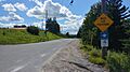
Old Soo Road in Lively, one of a number of mixed-traffic sections of the trail.
