Bollinger County, Missouri facts for kids
Quick facts for kids
Bollinger County
|
|
|---|---|

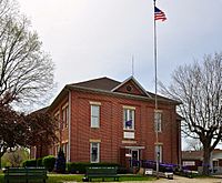
Bollinger County Courthouse, April 2014
|
|

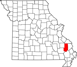
Location within the U.S. state of Missouri
|
|
 Missouri's location within the U.S. |
|
| Country | |
| State | |
| Founded | March 1, 1851 |
| Named for | George Frederick Bollinger |
| Seat | Marble Hill |
| Largest city | Marble Hill |
| Area | |
| • Total | 621 sq mi (1,610 km2) |
| • Land | 618 sq mi (1,600 km2) |
| • Water | 3.3 sq mi (9 km2) 0.5% |
| Population
(2020)
|
|
| • Total | 10,567 |
| • Density | 17.016/sq mi (6.570/km2) |
| Time zone | UTC−6 (Central) |
| • Summer (DST) | UTC−5 (CDT) |
| Congressional district | 8th |
Bollinger County is a county located in the southeastern part of the U.S. state of Missouri. In 2020, about 10,567 people lived here. The main town, called the county seat, is Marble Hill. It's also the biggest and only city in the county.
Bollinger County is mostly a rural area, meaning it has lots of countryside and farms. Its economy is supported by farming and building work. The county was officially started in March 1851. It was named after George Frederick Bollinger, who was an early settler in the area.
This county is part of the larger Cape Girardeau and Illinois Metropolitan Statistical Area. It's also famous for the "Missouri dinosaur" bones found near Glen Allen in 1942. Plus, Blue Pond, the deepest natural pond in Missouri, is located in the southern part of the county.
Contents
History
In the fall of 1799, a settler named George Frederick Bollinger moved to this area. He was from North Carolina and had German family roots. He convinced about 20 other families to leave North Carolina and settle west of what is now Cape Girardeau, Missouri.
To get the land, Bollinger had to sign a paper saying he and his group were Roman Catholics. But most of them were actually from the German Reformed Church, not Catholic. However, Don Louis Lorimier, who was in charge of land in Cape Girardeau for Spain, was impressed by Bollinger. So, he decided to let them settle there anyway.
The Bollinger group moved into an area known as the "Dutch Settlement" in January 1800. This was along the Whitewater River. They crossed the Mississippi River with their wagons because it was so cold the river had frozen solid!
Later, the land changed hands quickly. It went from Spain to France, and then in 1803, it became part of the United States through the Louisiana Purchase. This change wasn't good for the Shawnee people who had settled there earlier. In 1825, the U.S. government made a treaty with the Shawnee. This treaty forced them to move to what is now Shawnee Mission, Kansas. This land had belonged to the Osage tribes before. Some routes of the Cherokee Trail of Tears also passed through parts of Bollinger County, like Sedgewickville, Glennon, and Zalma.
The area west of Cape Girardeau became Bollinger County in 1851. It was named after George Frederick Bollinger. The county seat was first called Dallas, but its name was changed to Marble Hill in 1865. In the next county over, Madison County, the town of Fredericktown was also named after Bollinger.
Geography
Bollinger County covers about 621 square miles. Most of this is land (618 square miles), and a small part is water (3.3 square miles). The land in the county changes a lot. In the south, it's flat like the Mississippi Delta. But in the north, you'll find hills that are part of the Ozark Hills.
Neighboring Counties
- Perry County (north)
- Cape Girardeau County (east)
- Stoddard County (south)
- Wayne County (southwest)
- Madison County (northwest)
Main Roads
Protected Areas
- Mark Twain National Forest (part of it is in Bollinger County)
People and Population
| Historical population | |||
|---|---|---|---|
| Census | Pop. | %± | |
| 1860 | 7,371 | — | |
| 1870 | 8,162 | 10.7% | |
| 1880 | 11,130 | 36.4% | |
| 1890 | 13,121 | 17.9% | |
| 1900 | 14,650 | 11.7% | |
| 1910 | 14,576 | −0.5% | |
| 1920 | 13,909 | −4.6% | |
| 1930 | 12,269 | −11.8% | |
| 1940 | 12,898 | 5.1% | |
| 1950 | 11,019 | −14.6% | |
| 1960 | 9,167 | −16.8% | |
| 1970 | 8,820 | −3.8% | |
| 1980 | 10,301 | 16.8% | |
| 1990 | 10,619 | 3.1% | |
| 2000 | 12,029 | 13.3% | |
| 2010 | 12,363 | 2.8% | |
| 2020 | 10,567 | −14.5% | |
| U.S. Decennial Census 1790-1960 1900-1990 1990-2000 2010-2020 |
|||
In 2000, there were about 12,029 people living in Bollinger County. Most people in the county were White. A small number of people were Native American, Asian, or Black. About 0.57% of the people were Hispanic or Latino.
The average age of people in the county was 38 years old. About 26% of the population was under 18 years old.
Religion
Bollinger County is part of the "Bible Belt," which means many people there are Protestant Christians. The most common religions are Southern Baptists, Roman Catholics, and United Methodists.
2020 Census
| Race | Num. | Perc. |
|---|---|---|
| White (NH) | 9,862 | 93.33% |
| Black or African American (NH) | 35 | 0.33% |
| Native American (NH) | 30 | 0.3% |
| Asian (NH) | 20 | 0.2% |
| Pacific Islander (NH) | 3 | 0.03% |
| Other/Mixed (NH) | 464 | 4.4% |
| Hispanic or Latino | 153 | 1.5% |
Economy
Life in Bollinger County is generally less expensive than in many other parts of the U.S. The unemployment rate (the number of people looking for jobs who can't find them) is usually lower than the average for Missouri and the whole country.
The main jobs in Bollinger County are in manufacturing (making things in factories), healthcare and social services, construction (building things), and retail trade (selling goods in stores). For men, common jobs include construction, farming, and truck driving. For women, common jobs are in healthcare, education, and making clothes.
Most people (78%) work for a private company. About 10% work for the government, and 11% are self-employed (they work for themselves). Most workers (76%) drive their own cars to work.
Farming
Farming is very important to Bollinger County's economy. The average farm size is about 250 acres. Farmers earn money from selling their crops and animals. The most common crops grown here are soybeans, corn, and wheat. Many farms are run by families or individuals.
Education
In 2007, about 70.7% of adults in Bollinger County had finished high school. About 6.9% had earned a bachelor's degree or higher from college.
Public Schools
- Leopold R-III School District – Leopold
- Leopold Elementary School (Kindergarten–6th grade)
- Leopold High School (7th–12th grade)
- Meadow Heights R-II School District – Patton
- Meadow Heights Elementary School (Pre-Kindergarten–6th grade)
- Meadow Heights High School (7th–12th grade)
- Woodland R-IV School District – Marble Hill
- Woodland Elementary School (Kindergarten–4th grade)
- Woodland Middle School (5th–8th grade)
- Woodland High School (9th–12th grade)
- Zalma R-V School District – Zalma
- Zalma Elementary School (Kindergarten–6th grade)
- Zalma High School (7th–12th grade)
Public Libraries
- Bollinger County Library
Climate and Weather
Missouri generally has a climate with cool to cold winters and long, hot summers. Bollinger County is in a part of Missouri that gets very cold air from the Arctic and hot, humid air from the Gulf of Mexico. This means the county often has big changes in temperature.
Average temperatures in Bollinger County range from about 22°F (–6°C) in January to 89°F (32°C) in July.
Here are some weather facts about Bollinger County:
- The warmest month on average is July.
- The highest temperature ever recorded was 108°F (42°C) in 1954.
- January is the coolest month on average.
- The lowest temperature ever recorded was –27°F (–33°C) in 1951.
- The most rain usually falls in March (about 4.91 inches).
Bollinger County experiences more tornadoes than the U.S. average. Between 1950 and 2004, tornadoes caused one death and 24 injuries. On April 27, 2002, a strong tornado (called an F3) hit the area. It had winds up to 206 mph. It sadly killed a teenage boy between Hahn and Marble Hill, injured 16 people, and caused $4 million in damage.
2023 Tornado
In the early morning of April 5, 2023, another tornado, an EF2, caused damage in Glen Allen and Grassy. This tornado tragically killed 5 people and injured many others.
Fun Places to Visit
Bollinger County is part of Missouri's River Heritage Region and has several interesting historical spots:
- The Bollinger County Museum of Natural History in Marble Hill has a growing collection of natural history items and Native American artifacts. It's also home to "the Missouri dinosaur."
- The Massey Log House, built in 1869, is in Marble Hill.
- The Alma Fisher One-Room School, also in Marble Hill, shows what old schoolhouses were like.
- The Cat Ranch Art Guild in Marble Hill helps promote art in the county. It was started to honor a local artist named Tom Runnels.
- St. John's Catholic Church in Leopold has one of the oldest pipe organs west of the Mississippi River.
Communities
City
Villages
Other Communities
Townships
Bollinger County is divided into eight areas called townships:
|
|
Famous People
- Madison Roswell Smith – He was a U.S. ambassador to Haiti and a U.S. representative for Missouri.
- James Fulton Zimmerman – An educator and historian.
- Orville Zimmerman – A U.S. representative for Missouri.
See also
 In Spanish: Condado de Bollinger para niños

