
Brandywine Creek (Christina River tributary) facts for kids
Quick facts for kids Brandywine Creek |
|
|---|---|

Hagley mill race on the Brandywine
|
|

Christina River Basin, including Brandywine Creek
|
|
| Country | United States |
| State | Pennsylvania, Delaware |
| Cities | Chadds Ford, PA, Wilmington, DE |
| Physical characteristics | |
| Main source | West Branch Brandywine Creek Honey Brook Township, Chester County, Pennsylvania 850 ft (260 m) 40°06′51″N 75°55′35″W / 40.11417°N 75.92639°W |
| 2nd source | East Branch Brandywine Creek Honey Brook Township, Chester County, Pennsylvania 686 ft (209 m) 40°07′09″N 75°53′15″W / 40.11917°N 75.88750°W |
| River mouth | Christina River Wilmington, New Castle County, Delaware, USA 0 ft (0 m) 39°43′55″N 75°31′53″W / 39.73194°N 75.53139°W |
| Length | 20 mi (32 km) |
| Basin features | |
| Basin size | 300 sq mi (780 km2) |
| Tributaries |
|

The Brandywine Creek (also known as the Brandywine River) is a stream that flows into the Christina River. It runs through southeastern Pennsylvania and northern Delaware in the United States. The main part of the Brandywine is about 20 miles (32 km) long. It is even called a "Pennsylvania Scenic River" because of its beauty.
The creek starts with two main branches, the East Branch and West Branch. They begin close to each other in Honey Brook Township, Pennsylvania. This is about 20 miles (32 km) northwest of where they join.
The Brandywine Creek flows into the Christina River in Wilmington, Delaware. This spot was where the New Sweden colony first settled on March 29, 1638. A famous battle, the Battle of Brandywine, happened near the creek in Chadds Ford, Pennsylvania. This was on September 11, 1777, during the American Revolution.
The creek's water power was very important for early American industry. It ran gristmills in Brandywine Village and the nearby DuPont gunpowder mill. These mills were key before steam power became common.
Contents
Where Does the Brandywine Creek Flow?
The Brandywine Creek starts with two branches, the East Branch and West Branch. Both begin in western Chester County, Pennsylvania, near Honey Brook. The East Branch flows for about 27 miles (44 km). The West Branch flows for about 33 miles (53 km).
They meet about 10 miles (16 km) southeast of Coatesville. This meeting point is between East Bradford Township and Pocopson Township. After they join, the combined stream is called Brandywine Creek. It keeps flowing southeast through Chester County.

The creek passes Chadds Ford in Delaware County, Pennsylvania. Then it enters the state of Delaware about 5 miles (8 km) north of Wilmington. In Delaware, the creek flows through First State National Historical Park and Brandywine Creek State Park. It then goes into Wilmington, passing through Brandywine Park.
The Brandywine Creek joins the Christina River about 1 mile (1.6 km) east of downtown Wilmington. The Christina River then flows into the Delaware River estuary. The Christina also gets water from the White Clay Creek and Red Clay Creek. Where the Christina and Delaware rivers meet, it's the rough line between fresh and saltwater.
Many towns are in the Brandywine Valley. In Pennsylvania, these include Chadds Ford, Downingtown, and parts of West Chester. In Delaware, towns like Centreville and Greenville are part of it.
A Look Back: History of the Brandywine
Native Americans called the Lenape Nation lived along the Brandywine Creek. They spoke Algonquian. They hunted, farmed corn, beans, and squash, and fished. The Brandywine was especially good for catching shad fish. The Lenape had many names for the creek, like Wauwaset and Wawassan.
Early European Settlers
The first Europeans to settle on the Brandywine were Swedish. On March 29, 1638, Peter Minuit started the New Sweden colony. This was near where the Christina and Brandywine rivers meet, at Fort Christina in modern-day Wilmington. About 600 Swedes, Finns, and Dutch people settled there. They are known for bringing the log cabin to America.
The Swedes called the creek Fiskiekylen, meaning "Fish Creek." The name "Brandywine" might come from an old Dutch word for brandy or gin, brandewijn. Or it could be from the Swedish word brännvin (Swedish vodka). Some say a Dutch ship carrying brandy sank in the creek due to ice in 1655. Another idea is that it came from an early mill owner, Andreas Brainwende.
The Swedes, Dutch, and English fought over the area until 1674, when England took control. William Penn received a charter for Pennsylvania in 1681. He soon gained control over what is now Delaware. By 1687, a Swedish colonist, Tyman Stidham, opened the first mill on the Brandywine near Wilmington.
Lenape and Quakers

Even though the Lenape were still along the Brandywine, their numbers had dropped greatly. This was due to European diseases and wars with other tribes. They signed treaties with Europeans, but were forced out of eastern Pennsylvania by the time of the French and Indian War. The Lenape complained that mill dams on the creek were harming their shad fishing.
Indian Hannah (1730–1802) is thought to be the last Lenape to live in Chester County. She is buried near the creek's forks.

Many Quakers and other Protestants settled the valley. They focused on farming and milling. Quaker influence is still strong today, with many Quaker schools and meetings in the area. The Quaker millers near the Brandywine's mouth worked together to keep their flour high quality. Their "Brandywine Superfine" flour was sold all along the Atlantic coast.
Revolutionary War and Art
The creek is famous for the 1777 Battle of Brandywine during the American Revolutionary War. British General William Howe marched towards Philadelphia. He needed to cross the Brandywine near Chadds Ford. General George Washington placed most of his American troops along the creek. The Brandywine Battlefield Park marks this historic area.
Before the battle, General Anthony Wayne had his headquarters in Brandywine Village. Early paper mills along the creek were important during the Revolution. They supplied Benjamin Franklin's print shop and paper for the Declaration of Independence.
The Conestoga wagon was first built to carry grain to the Brandywine flour mills.
A group of famous painters, including N.C. Wyeth, Andrew Wyeth, and Howard Pyle, are known as the "Brandywine School." They are famous for their landscape paintings of the Brandywine valley. Many of their artworks can be seen at the Brandywine River Museum in Chadds Ford.
Brandywine Village and Early Industry

The Brandywine Creek drops sharply in elevation just north of Wilmington. This drop provided strong water power for early industries. These included flour milling and the first DuPont gunpowder mills. The creek's connection to the Delaware River allowed goods to be shipped easily.
In 1687, Tyman Stidham opened the first mill on the Brandywine. Around 1735, Brandywine Village was founded across the creek from Wilmington. By 1743, a dam and a millrace (a channel for water to power a mill) were built. In 1760, a bridge was built where the Market Street Bridge is today. More flour mills were added.
Oliver Evans helped mills become more efficient in the 1780s. This was a big step in the Industrial Revolution. Delaware's first paper mill opened in 1787. This site later became Bancroft Mills, a huge textile mill.
By 1796, Brandywine Village had 12 mills. They could grind 400,000 bushels of grain each year. In 1802, Eleuthère Irénée du Pont bought land on the creek. He started gunpowder mills there, known as the Eleutherian Mills. By 1810, it was the biggest gunpowder producer in the country. During the Civil War, over 4 million barrels of gunpowder were made here. These mills, which closed in 1921, are now part of the Hagley Museum and Library.

The millers worked together to ensure their flour was high quality. "Brandywine Superfine" flour was shipped all over the Atlantic coast. A mill race that once powered mills is still working in Brandywine Park in Wilmington.
Further north, Downingtown was known as Milltown. It had grist mills built in the early 1700s. By the 1880s, Downingtown became known for its paper mills. Coatesville, on the west branch, became famous for making iron goods from 1810. Today, Mittal still makes steel there.
Protecting History: Historic Places
Many places near the Brandywine Creek are listed on the National Register of Historic Places. This means they are important historical sites.
| Site | Address | Listed |
|---|---|---|
| Fort Christina | E. 7th Street, Wilmington, Delaware Near mouth of creek 39°44′14″N 75°32′18″W / 39.73722°N 75.53833°W |
1961, 1966 |
| Old Swedes Church | E. 7th Street at Church Street 39°44′18″N 75°32′26″W / 39.73833°N 75.54056°W |
1961, 1966 |
| Brandywine Village | North and east of Market Street Bridge 39°45′06″N 75°32′33″W / 39.7518°N 75.5425°W |
1971, 1976 |
| Brandywine Park | North of Market Street Bridge to Augustine Bridge 39°45′18″N 75°33′00″W / 39.7550°N 75.5500°W |
1976 |
| Bancroft Mills | Rockford Road at the Brandywine 39°46′07″N 75°33′57″W / 39.7685°N 75.5657°W |
1984 |
| Eleutherian Mills | Rt. 141 at Brandywine Creek Bridge 39°46′29″N 75°34′42″W / 39.7746°N 75.5783°W |
1966 |
| Brandywine Powder Mills District | Rt. 141 at the Brandywine 39°46′48″N 75°34′40″W / 39.78000°N 75.57778°W |
1984 |
| N.C. Wyeth House and Studio | Murphy Rd. near Creek Road, Chadds Ford, Pennsylvania 39°52′05″N 75°35′10″W / 39.868°N 75.586°W |
1979 |
| Chadds Ford Historic District | U.S. Route 1 at Creek Road, Chadds Ford, Pennsylvania 39°52′19″N 75°35′28″W / 39.8719°N 75.5911°W |
1971 |
| Brandywine Battlefield | U.S. Route 1 east of Brandywine Creek, Chadds Ford, Pennsylvania 39°52′31″N 75°34′31″W / 39.87528°N 75.57528°W |
1966 |
| Downingtown Log House | 15 E. Lancaster Ave., Downingtown, Pennsylvania on East Branch Brandywine Creek 40°00′23″N 75°42′15″W / 40.0064°N 75.7043°W |
1979 |
| Roger Hunt Mill | Race Street, Downingtown, PA 40°00′30″N 75°42′39″W / 40.0084°N 75.7108°W |
1979 |
| Embreeville Historic District | West Branch Rt. 162 at Cannery Rd. 39°55′38″N 75°43′50″W / 39.9273°N 75.7306°W |
1985 |
| Coatesville Historical District | 1st–6th Streets and East Lincoln Highway at West Branch Brandywine Creek, Coatesville, Pennsylvania 39°58′58″N 75°49′21″W / 39.9828°N 75.8225°W |
1987 |
Ecology: Helping Fish Return
In 2019, the first of eight dams on Brandywine Creek was removed. This helps American shad (a type of fish) swim further up the river. These dams blocked the shad from reaching their spawning grounds in Pennsylvania. A project called "Brandywine Shad 2020" aims to remove all eight dams. This project is led by Professor Jerry Kauffman from the University of Delaware Water Resources Center.
Images for kids
-
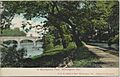
A postcard from about 1905, showing the Brandywine looking downstream towards the Van Buren Street Bridge in Wilmington. Notice the mill race on the right.
-
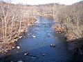
Brandywine Creek in Wilmington in 2006.
-
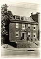
The William Lea house in Brandywine Village.
-
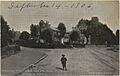
Brandywine Village from the Market Street Bridge, from a postcard dated 1906.
-
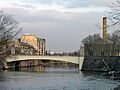
The Market Street Bridge, looking downstream. Brandywine Village is on the left, and the Wilmington Pumping Station is on the right.
-
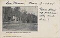
DuPont gunpowder mills on the Brandywine, from a 1905 postcard. These mills were still working then.
-
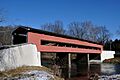
Smith's Covered Bridge.
-

Canoeing near Pocopson.
-
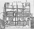
Oliver Evans's design for automated flour milling.


