
Brussels facts for kids
Quick facts for kids
Brussels
|
|||
|---|---|---|---|
|
A collage with several views of Brussels, Top: Northern Quarter business district, 2nd left: Flower Carpet event at the Grand-Place/Grote Markt, 2nd right: Town Hall and Mont des Arts/Kunstberg area, 3rd: Parc du Cinquantenaire/Jubelpark, 4th left: Manneken Pis, 4th middle: Cathedral of St. Michael and St. Gudula, 4th right: Congress Column, Bottom: Royal Palace
|
|||
|
|||
| Nickname(s):
BXL
|
|||

Brussels
Location in Belgium

Brussels
Location in Europe
|
|||
| Country | |||
| Community | French Community Flemish Community |
||
| Settled | c. 580 | ||
| Founded | 979 | ||
| County of Brussels | c. 870 | ||
| City Charter of Brussels | 10 June 1229 | ||
| Region | 18 June 1989 | ||
| Founded by | Charles, Duke of Lower Lorraine | ||
| Capital | City of Brussels | ||
| Municipalities |
List
Anderlecht
Auderghem / Oudergem Berchem-Sainte-Agathe / Sint-Agatha-Berchem Bruxelles-Ville / Brussel-Stad Etterbeek Evere Forest / Vorst Ganshoren Ixelles / Elsene Jette Koekelberg Molenbeek-Saint-Jean / Sint-Jans-Molenbeek Saint-Gilles / Sint-Gillis Saint-Josse-ten-Noode / Sint-Joost-ten-Node Schaerbeek / Schaarbeek Uccle / Ukkel Watermael-Boitsfort / Watermaal-Bosvoorde Woluwe-Saint-Lambert / Sint-Lambrechts-Woluwe Woluwe-Saint-Pierre / Sint-Pieters-Woluwe |
||
| Area | |||
| • Region/City | 162.4 km2 (62.7 sq mi) | ||
| Elevation | 13 m (43 ft) | ||
| Population
(1 January 2023)
|
|||
| • Region/City | 1,235,192 | ||
| • Estimate
(1 January 2020)
|
1,212,352 | ||
| • Density | 7,605.9/km2 (19,699/sq mi) | ||
| • Metro | 2,500,000 | ||
| Demonym(s) | |||
| Demographics | |||
| • Official languages | French • Dutch | ||
| • Ethnic groups | 25.7% Belgian 74.3% others • 41.8% non-European |
||
| GDP | |||
| • Region/City | €96.513 billion (2022) | ||
| • Metro | €200.457 billion (2022) | ||
| Time zone | UTC+1 (CET) | ||
| • Summer (DST) | UTC+2 (CEST) | ||
| Postal code(s) |
42 postal codes
|
||
| Area code(s) | 02 | ||
| ISO 3166 code | BE-BRU | ||
| GeoTLD | .brussels | ||
| HDI (2019) | 0.948 very high · 1st of 11 |
||
.jpg)

.jpg)
.jpg)

_St._Michael_%26_St._Gudula_Cathedral_Tower,_Brussels.jpg)
.jpg)


Brussels is a special region in Belgium. It has 19 different towns, and one of them, the City of Brussels, is the capital of Belgium! Brussels is in the middle of the country. It's part of both the French and Flemish communities.
Long ago, people in Brussels mostly spoke Dutch. But over time, more and more people started speaking French. Today, Brussels is officially bilingual, meaning both French and Dutch are spoken. French is the main language, but many people also speak English and other languages.
Brussels started as a small village by the Senne River. It grew into an important city in Europe. After World War II, Brussels became a major center for international politics. Many global organizations, diplomats, and leaders are based here. It's often called the de facto capital of the European Union (EU). This is because many important EU offices are in Brussels. You'll also find the headquarters of NATO here.
Brussels is the most crowded region in Belgium. It covers about 162 square kilometers and has over 1.2 million people. Its larger metropolitan area has more than 2.5 million people, making it the biggest in Belgium. Brussels is a major economic hub in Western Europe. It's also a key center for trains, roads, and air travel. The Brussels Metro is Belgium's only subway system. Its airport and train stations are the busiest in the country.
Brussels is famous for its delicious food, like its waffles, chocolate, and many types of beer. It also has amazing historical buildings. Some of these are even protected as UNESCO World Heritage Sites. Popular places to visit include the Grand-Place (main square), Manneken Pis, and the Atomium. Brussels is also known as a capital of Belgian comics.
Contents
Brussels' Story: A Journey Through Time
How Brussels Began

The story of Brussels is connected to the history of Western Europe. People lived here as far back as the Stone Age. The official start of Brussels is usually set around 979. This is when Duke Charles of Lower Lorraine moved important religious items to a chapel on an island in the Senne River. He also built the city's first strong fort on that island.
Growing in the Middle Ages
Around the year 1000, Brussels became part of the County of Leuven. Its location on the Senne River, along a trade route between cities like Bruges and Ghent, helped it become a busy center for selling textiles. The town grew quickly, spreading to higher ground where there was less risk of floods. By 1183, the leaders of Leuven became Dukes of Brabant.
In the early 1200s, Brussels built its first city walls. The city kept growing, and work began on the beautiful Cathedral of St. Michael and St. Gudula in 1225. Later, between 1356 and 1383, a second set of walls was built to protect the larger city. You can still see parts of these old walls today.
From Dukes to Empires

In the 14th century, Brussels became part of the powerful Duchy of Burgundy. Later, through a royal marriage, it came under the rule of the House of Habsburg. Brussels became a very important capital for the rich Burgundian Netherlands.
One of the most famous rulers was Charles V. He was born in Ghent and became King of Spain and Holy Roman Emperor. Brussels was one of his main capitals. In 1555, he gave up his power in the Palace of Coudenberg. This grand palace was later destroyed by fire in 1731.

In the 16th and 17th centuries, Brussels was known for its lace and tapestries. But in 1695, during a war, the French army attacked Brussels with cannons. This was the most damaging event in the city's history. The Grand-Place and thousands of buildings were destroyed. The city was rebuilt in the years that followed, changing its look forever.
After 1713, Brussels was ruled by Austria. Then, in 1795, France took control. French rule ended in 1815 after Napoleon was defeated at the Battle of Waterloo, which is near Brussels. The city then joined the United Kingdom of the Netherlands.
Modern Brussels Takes Shape
In 1830, the Belgian Revolution started in Brussels. The city became the capital of the new country of Belgium. On July 21, 1831, Leopold I became the first King of the Belgians. He oversaw the removal of the old city walls and the building of many new structures.

Brussels grew a lot in the 19th century. Its population went from about 80,000 to over 625,000 people. The Senne River had become very dirty, so from 1867 to 1871, it was completely covered over. This allowed for new, modern buildings and wide boulevards, which you can still see in downtown Brussels today. Famous buildings like the Brussels Stock Exchange and the Palace of Justice were built during this time.
Brussels also became a major center for the Art Nouveau style in the late 1800s. Architects like Victor Horta created beautiful, flowing designs.
Brussels in the 20th Century

In the 20th century, Brussels hosted many important events, including three world's fairs. During both World War I and World War II, Brussels was occupied by German forces. Luckily, it did not suffer much damage. British troops freed the city on September 3, 1944.

After World War II, Brussels modernized a lot. New railway connections and subway lines were built. In the 1960s, Brussels became the main capital of what is now the European Union. Many modern office buildings were constructed for this purpose. Sometimes, this rapid building led to the demolition of older, beautiful buildings, a process called "Brusselisation."
Brussels Today
The Brussels-Capital Region was officially created on June 18, 1989. It is one of Belgium's three federal regions and has a bilingual status. The yellow iris flower is the symbol of the region.
Brussels continues to host major international events. It was a European Capital of Culture in 2000. It has also hosted several NATO Summits.
Brussels as a Capital City
Brussels is the capital of Belgium. The City of Brussels is the specific municipality that serves as the country's core capital.
Many important national buildings are located in the City of Brussels.
- The Royal Palace of Brussels is where the King of the Belgians works.
- The Palace of the Nation is where Belgium's laws are made.
- The office of the Prime Minister of Belgium is also nearby.
- The Court of Cassation, Belgium's highest court, is in the Palace of Justice.
The City of Brussels is also the capital for both the French Community and the Flemish Community in Belgium. Their parliaments and governments are located here.

Languages of Brussels

When Belgium became a country in 1830, Brussels was mostly Dutch-speaking. But over time, it changed to a city where French is the main language. This shift happened because many French-speaking people moved there. Also, many Dutch-speaking people in Brussels started learning and using French. This was partly because French had higher social status in Belgium at the time. By the mid-20th century, most people in Brussels spoke French.
Brussels Culture: Art, Food, and Fun!
Amazing Architecture

Brussels has many different styles of buildings. You can see medieval buildings on the Grand Place and modern buildings for the EU.
Some key sights include:
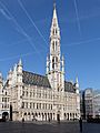
- The Grand Place, a UNESCO World Heritage Site since 1988, with its Gothic town hall.
- The Cathedral of St. Michael and St. Gudula.
- The Royal Castle of Laken with its large greenhouses.
- The Royal Palace of Brussels.
The Atomium is a famous 103-meter-tall structure built for the 1958 World's Fair. It looks like an iron crystal model. Next to it is the Mini-Europe park, which has tiny models of famous European buildings.
The Manneken Pis, a small statue of a peeing boy, is a well-known symbol of the city.
Other important landmarks are the Cinquantenaire park with its arch and museums, the Basilica of the Sacred Heart, and the buildings of the EU in the European Quarter.

Brussels also has many cultural places like the La Monnaie Theatre for opera. There are over 80 museums, including the Royal Museum of Fine Art and the Comic Museum. Brussels has a lively music scene, from opera to techno clubs.
Many buildings in Brussels show the Art Nouveau style. Architects like Victor Horta were famous for their designs. You can see great examples in areas like Schaerbeek and Ixelles.
Arts and Creativity
Brussels has a long history of famous artists. The surrealist painter René Magritte studied here. The city is also known as a capital of comic strips. Famous Belgian comic characters include Lucky Luke, Tintin, and Marsupilami. You can see large comic book murals painted on city walls. The Belgian Comics Museum celebrates this art form.
The Royal Museums of Fine Arts of Belgium have a huge collection of paintings. These include works by famous Flemish painters like Bruegel. The Magritte Museum has the world's largest collection of René Magritte's art.
The King Baudouin Stadium is Belgium's largest concert and sports venue, holding 50,000 people.
Delicious Food and Drinks

Brussels is known for its delicious local waffles, chocolate, French fries, and many types of beers. The Brussels sprout vegetable even got its name from the city!
You can find about 1,800 restaurants in Brussels. Belgian food is considered some of the best in Europe. Besides restaurants, there are many cafes and bistros. Cafes offer beer and light meals. Brasseries often have a wide selection of beers and traditional Belgian dishes.
Belgian food mixes French cooking with heartier Flemish dishes. Popular specialties include Brussels waffles and mussels with fries. Brussels is a hub for chocolate makers like Neuhaus and Godiva. You can also find many places selling fresh, hot waffles on the street.
Besides regular Belgian beers, the unique lambic beer is only brewed in and around Brussels. Kriek (cherry beer) is very popular and can be found in almost every bar.
Brussels' Economy

Brussels' economy is mostly based on services. This is because it's a center for many international companies and European institutions. It also has some special craft industries, like the Cantillon Brewery, which makes traditional lambic beer.
Getting Around Brussels
Travel by Air
Brussels has two airports. Brussels Airport is in nearby Zaventem. The smaller Brussels South Charleroi Airport is about 50 km away. Brussels is also connected to other European cities by high-speed trains like Eurostar (to London) and Thalys (to Amsterdam, Paris, and Cologne).
Waterways
Brussels has its own port on the Brussels-Scheldt Maritime Canal. The Brussels-Charleroi Canal links Brussels to industrial areas in Wallonia.
Public Transportation
The Brussels Metro started in 1976. Before that, underground tram lines were used. The city also has a large network of buses and trams.
You can use one ticket for different types of public transport in the city. Commuter trains will soon be part of a new network around the city. Brussels also has car-sharing and shared bicycle services.
Roads and Highways

In old times, Brussels was at the crossing of important trade routes. Today, the city's main streets still spread out from the Grand Place. Many boulevards were built over the Senne River and the old city walls.
Brussels is a central point for national roads. These main roads usually run straight, but sometimes they go through narrow shopping streets.
The city is circled by major European highways like the E19 and E40. Brussels also has a ring road, called the "ring" (R0). The city center, known as "the pentagon," is surrounded by an inner ring road (R20), which follows the path of the old city walls.

Notable people
Sister Cities
Brussels is connected to these cities around the world:
Images for kids
-
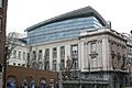
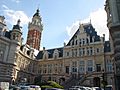
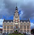
The Brussels Parliament building
-
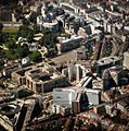
Aerial view of the European Quarter
-
The Place du Luxembourg/Luxemburgplein with the European Parliament in the background
-
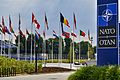
Flags of NATO member states wave at the entrance of NATO's headquarters in Haren
-
Headquarters of Eurocontrol in Haren
-
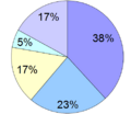
Languages spoken at home in the Brussels-Capital Region (2013) French Dutch and French Dutch French and other language Neither Dutch nor French
-
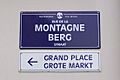
Bilingual French and Dutch street signs in Brussels
-
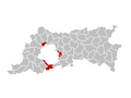
The municipalities with language facilities (in red) near Brussels
-
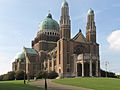
The National Basilica of the Sacred Heart in Koekelberg
-
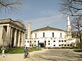
The Great Mosque of Brussels is the seat of the Islamic and Cultural Centre of Belgium.
-
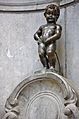
Manneken Pis is a well-known public sculpture in Brussels.
-
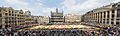
The Grand Place of Brussels, a UNESCO World Heritage Site
-
Flagey Building (or Maison de la Radio) in Ixelles
-
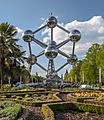
The Atomium, a landmark of Brussels
-
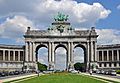
The Cinquantenaire/Jubelpark memorial arcade and museums
-
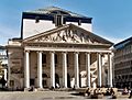
The Royal Theatre of La Monnaie
-
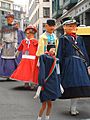
Meyboom giants in Brussels, a UNESCO Intangible Cultural Heritage
-
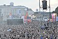
Brussels Summer Festival (BSF)
-
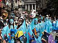
Zinneke Parade of Brussels
-
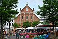
Flea market on the Place du Jeu de Balle/Vossenplein
-
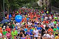
20 km of Brussels
-
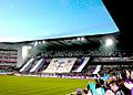
R.S.C. Anderlecht fans at the Constant Vanden Stock Stadium
-
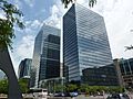
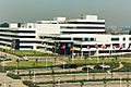
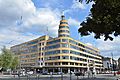
Brussels' Northern Quarter business district
-
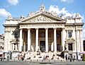
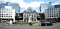
The former Brussels Stock Exchange building
-
Main building on the Solbosch campus of the Université libre de Bruxelles (ULB)
-
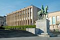
The Royal Library of Belgium (KBR)
-
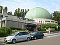
The Planetarium of the Royal Observatory of Belgium
-
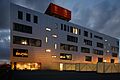
Erasmus Hospital in Anderlecht
-
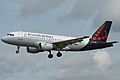
Brussels Airlines Airbus A319 landing at Brussels Airport in Zaventem
-
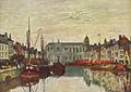
The Saint Catherine Dock, Eugène Boudin, 1871
-
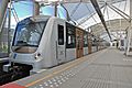
Brussels Metro carriage at Erasme/Erasmus metro station
-
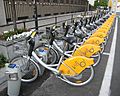
Villo! shared bicycles in Brussels
-
Auderghem (Oudergem)
-
Berchem-Sainte-Agathe (Sint-Agatha-Berchem)
-
City of Brussels
-
Forest (Vorst)
-
Ixelles (Elsene)
-
Molenbeek-Saint-Jean (Sint-Jans-Molenbeek)
-
Saint-Gilles (Sint-Gillis)
-
Saint-Josse-ten-Noode (Sint-Joost-ten-Node)
-
Schaerbeek (Schaarbeek)
-
Uccle (Ukkel)
-
Watermael-Boitsfort (Watermaal-Bosvoorde)
-
Woluwe-Saint-Lambert (Sint-Lambrechts-Woluwe)
-
Woluwe-Saint-Pierre (Sint-Pieters-Woluwe)
-
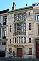
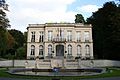
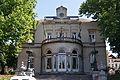
Hôtel Tassel by Victor Horta (1893)
-
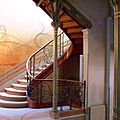
Stairway in Hôtel Tassel
-
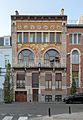
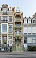
Hôtel Ciamberlani by Paul Hankar (1897)
-
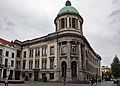
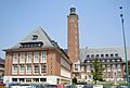
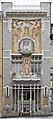
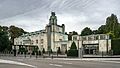
Former Old England department store by Paul Saintenoy (1899)
-
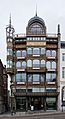
Saint-Cyr House by Gustave Strauven (1903)
-
Cauchie House by Paul Cauchie (1905)
-
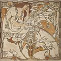
Sgraffito panel in the Cauchie House
-
Stoclet Palace by Josef Hoffmann (1911)


.jpg)

.PNG)


.jpg)


_landing_at_Brussels_Airport_(1).jpg)


.jpg)


.jpg)


_-_2264-0007-0.jpg)


.jpg)


.jpg)
.jpg)
.jpg)


See also
 In Spanish: Región de Bruselas-Capital para niños
