Clark County, Indiana facts for kids
Quick facts for kids
Clark County
|
||
|---|---|---|

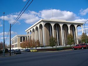
Clark County Courthouse in Jeffersonville, Indiana
|
||
|
||

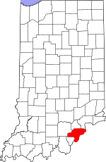
Location within the U.S. state of Indiana
|
||
 Indiana's location within the U.S. |
||
| Country | ||
| State | ||
| Founded | February 3, 1801 | |
| Named for | General George Rogers Clark | |
| Seat | Jeffersonville | |
| Largest city | Jeffersonville | |
| Area | ||
| • Total | 376.45 sq mi (975.0 km2) | |
| • Land | 372.86 sq mi (965.7 km2) | |
| • Water | 3.60 sq mi (9.3 km2) 0.96%% | |
| Population
(2020)
|
||
| • Total | 121,093 |
|
| • Density | 320/sq mi (120/km2) | |
| Time zone | UTC−5 (Eastern) | |
| • Summer (DST) | UTC−4 (EDT) | |
| Congressional district | 9th | |
|
||
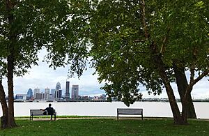
Clark County is a county in the U.S. state of Indiana. It is located right across the Ohio River from Louisville, Kentucky. In 2020, about 121,093 people lived there. The main city and county seat is Jeffersonville. Clark County is part of the larger Louisville area.
Contents
History of Clark County
Clark County is on the north side of the Ohio River. It was an important entry point into Indiana. People started settling here in 1783. General George Rogers Clark and his soldiers were given 150,000 acres of land by the state of Virginia. This was a reward for winning battles against the British. A small part of this land, 1,000 acres, became Clarksville. This was the first official American settlement in the Northwest Territory, started in 1784.
Clark County was officially formed on February 3, 1801. It was created from land that used to be part of Knox County. Over time, parts of Clark County were used to create many other counties in Indiana.
The first county seat was in Springville in 1801. Then, Jeffersonville became the county seat in 1802. But in 1810, the county seat moved to Charlestown. It stayed there until 1873, when it moved back to Jeffersonville.
Clark County was a strong supporter of ending slavery during the time it was a territory. Many people living there were Quakers. They had moved from North Carolina to escape places where slavery was common. They did not want slavery to be allowed in Indiana.
From its early days, Clark County's growth was connected to the Ohio River. In the 1800s, steamboats helped transport goods. This led to more businesses and factories in the county. In 1832, James Howard started the Howard shipyards. This made Clark County a leader in building boats.
Railroads also helped the economy grow. Lines like the Monon line and the Jeffersonville, Madison, and Indianapolis Railroad connected Clark County to bigger cities like Indianapolis and Chicago.
Other important businesses came to Clark County in the 1800s. These included the Louisville Cement Company in Speed, Indiana and the Ford Plate Glass Company in Jeffersonville.
In the 1920s, the Colgate-Palmolive Company moved to Clarksville. They bought an old prison building in 1923 and turned it into a factory. It operated there until 2008.
During World War II, Clark County became very busy. The government built the Indiana Arsenal near Charlestown in 1940. This factory made gunpowder for the war and employed up to 20,000 people. The Howard shipyards also built landing craft for the Navy. Later, Howard shipyards became Jeffersonville Boat and Machine Company, known as Jeffboat.
After the war, the county grew a lot. New roads like Interstate 65 made it easier for people to live and shop there.
Clark County's history is closely tied to the Ohio River. The river helped the county grow economically for a long time. Today, the county has many different types of businesses. It still looks to the river as a link to its important past.
Geography
Clark County is on the eastern edge of Indiana. Its eastern border is next to Kentucky, across the Ohio River. The land here has low, rolling hills. Some areas are used for farming, and others have cities and towns. The western part of the county has many small valleys and streams. The highest point is a ridge near Henryville, which is about 1,030 feet (314 meters) above sea level.
The county covers about 376.45 square miles (975.0 km2). Most of this, about 372.86 square miles (965.7 km2), is land. The rest, about 3.60 square miles (9.3 km2), is water.
Neighboring Counties
- Scott County - north
- Jefferson County – northeast
- Trimble County, Kentucky – northeast
- Oldham County, Kentucky – east
- Jefferson County, Kentucky – south
- Floyd County – southwest
- Washington County – west
Clark County is special because it borders two counties with the same name: Jefferson County in Indiana and Jefferson County in Kentucky.
Cities in Clark County
Towns in Clark County
Census-Designated Places
These are areas that are like towns but are not officially incorporated.
Unincorporated Places
These are smaller communities that are not part of any city or town.
- Arctic Springs
- Belknap
- Bennettsville
- Bethlehem
- Black Diamond
- Blue Lick
- Broom Hill
- Carwood
- Cementville
- Clarke
- Dallas
- Dyeton
- Floyd
- Hamburg
- Haussdale
- Henze
- Hibernia
- Hughes
- Longview Beach
- Marysville
- Nabb
- New Market
- Oak Park
- Otisco
- Otto
- Prairie Crossing
- Prather
- Pulltight
- River Ridge
- Rockford
- Solon
- Speed
- St Joseph
- Starlight
- Sunset Village
- Underwood
- Watson
- Wilson
Extinct Towns
These are towns that no longer exist.
- Andalusia
- Claysburg
- Oregon
- Port Fulton
- Springville
Townships
Clark County is divided into these smaller areas called townships.
- Bethlehem
- Carr
- Charlestown
- Jeffersonville
- Monroe
- Oregon
- Owen
- Silver Creek
- Union
- Utica
- Washington
- Wood
Transportation
- Transit Authority of River City (TARC) provides bus services.
Main Roads
Airport
- KJVY – Clark Regional Airport
Climate and Weather
| Weather chart for Jeffersonville, Indiana | |||||||||||||||||||||||||||||||||||||||||||||||
|---|---|---|---|---|---|---|---|---|---|---|---|---|---|---|---|---|---|---|---|---|---|---|---|---|---|---|---|---|---|---|---|---|---|---|---|---|---|---|---|---|---|---|---|---|---|---|---|
| J | F | M | A | M | J | J | A | S | O | N | D | ||||||||||||||||||||||||||||||||||||
|
3.3
41
25
|
3.3
47
29
|
4.4
57
37
|
3.9
67
46
|
4.9
75
56
|
3.8
83
65
|
4.3
87
70
|
3.4
86
68
|
3.1
79
61
|
2.8
68
49
|
3.8
56
39
|
3.7
45
30
|
||||||||||||||||||||||||||||||||||||
| temperatures in °F precipitation totals in inches source: The Weather Channel |
|||||||||||||||||||||||||||||||||||||||||||||||
|
Metric conversion
|
|||||||||||||||||||||||||||||||||||||||||||||||
In Jeffersonville, the average temperature in January is about 25°F (-4°C). In July, it's about 87°F (31°C). The coldest temperature ever recorded was -22°F (-30°C) in January 1994. The hottest was 107°F (42°C) in July 1936. The amount of rain changes throughout the year. May usually gets the most rain, and October gets the least.
In March 2012, two towns in Clark County, Marysville and Henryville, were badly damaged by tornadoes.
Population Information
| Historical population | |||
|---|---|---|---|
| Census | Pop. | %± | |
| 1810 | 5,670 | — | |
| 1820 | 8,709 | 53.6% | |
| 1830 | 10,686 | 22.7% | |
| 1840 | 14,595 | 36.6% | |
| 1850 | 15,828 | 8.4% | |
| 1860 | 20,502 | 29.5% | |
| 1870 | 24,770 | 20.8% | |
| 1880 | 28,610 | 15.5% | |
| 1890 | 30,259 | 5.8% | |
| 1900 | 31,835 | 5.2% | |
| 1910 | 30,260 | −4.9% | |
| 1920 | 29,381 | −2.9% | |
| 1930 | 30,764 | 4.7% | |
| 1940 | 31,020 | 0.8% | |
| 1950 | 48,330 | 55.8% | |
| 1960 | 62,795 | 29.9% | |
| 1970 | 75,876 | 20.8% | |
| 1980 | 88,838 | 17.1% | |
| 1990 | 87,774 | −1.2% | |
| 2000 | 96,472 | 9.9% | |
| 2010 | 110,232 | 14.3% | |
| 2020 | 121,093 | 9.9% | |
| 2023 (est.) | 125,467 | 13.8% | |
| US Decennial Census 1790–1960 1900–1990 1990–2000 2010–2019 |
|||
In 2010, there were 110,232 people living in Clark County. There were 44,248 households, and 29,474 families. The county had about 295.6 people per square mile. Most people (87.1%) were white. About 6.9% were black or African American. People of Hispanic or Latino origin made up 4.9% of the population.
The average household had 2.46 people, and the average family had 2.98 people. The average age of people in the county was 37.9 years old.
2020 Census Data
| Race | Number | Percent |
|---|---|---|
| White (not Hispanic) | 95,403 | 78.8% |
| Black or African American (not Hispanic) | 9,265 | 7.65% |
| Native American (not Hispanic) | 249 | 0.2% |
| Asian (not Hispanic) | 1,305 | 1.1% |
| Pacific Islander (not Hispanic) | 127 | 0.1% |
| Other/Mixed (not Hispanic) | 6,853 | 5.7% |
| Hispanic or Latino | 7,891 | 6.5% |
Education
Clark County has several public school districts and private schools. There are also two colleges where students can earn degrees.
Public School Districts
Clarksville Community School Corp.
- Clarksville Senior High School
- Clarksville Middle School
- Greenacres Elementary School
- George Rogers Clark Elementary School (Closed 2010)
West Clark Community School Corp.
- Silver Creek High School
- Borden Jr/Sr High School
- Henryville Jr/Sr High School
- Silver Creek Middle School
- Borden Elementary School
- Henryville Elementary School
- Silver Creek Elementary School
Greater Clark County Schools
- Charlestown Senior High School
- Jeffersonville High School
- New Washington High School
- Charlestown Middle School
- New Washington Middle School
- Parkview Middle School
- River Valley Middle School
- Bridgepoint Elementary School
- Maple Elementary School
- New Washington Elementary School
- Northaven Elementary School
- Parkwood Elementary School
- Pleasant Ridge Elementary School
- Jonathan Jennings Elementary School
- Riverside Elementary School
- Spring Hill Elementary School
- Thomas Jefferson Elementary School
- Utica Elementary School
- Wilson Elementary School
- Options Alternative School
- Corden Porter School
Private Schools
These schools are part of the Archdiocese of Indianapolis.
- Our Lady of Providence Junior-Senior High School
- St. Anthony of Padua Elementary School (Kindergarten to 7th grade)
- Sacred Heart of Jesus (Preschool to 8th grade)
- St. John Paul II School (Kindergarten to 8th grade)
Colleges and Universities
- Ivy Tech State College (a non-profit college)
- Mid-America College of Funeral Services (a non-profit college)
- Ottawa University – Jeffersonville (a non-profit university)
See also
 In Spanish: Condado de Clark (Indiana) para niños
 | Precious Adams |
 | Lauren Anderson |
 | Janet Collins |


