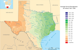
Climate of Texas facts for kids
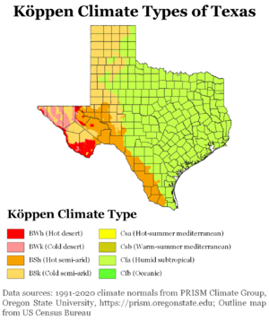
Texas has many different types of weather! It can be very dry in the west and very humid in the east. This huge state has several areas with unique climates: the Northern Plains, the Trans-Pecos Region, the Texas Hill Country, the Piney Woods, and South Texas. Generally, the part of Texas east of Interstate 35 is warm and humid, while the part west of Interstate 35 is a dry desert.
Texas gets more tornadoes than any other state, with about 139 each year. Big storms called tropical cyclones (like hurricanes) can also hit Texas. These storms can come from the Gulf of Mexico or even from the eastern Pacific Ocean. Storms from the Gulf are more likely to hit the upper Texas coast. Texas has also seen many big floods throughout history, both from tropical storms and from weather systems that get stuck.
Contents
Weather in Different Parts of Texas
Northern Plains
| City | Jan | Feb | Mar | Apr | May | Jun | Jul | Aug | Sep | Oct | Nov | Dec |
|---|---|---|---|---|---|---|---|---|---|---|---|---|
| Abilene | 55/32 | 61/37 | 69/44 | 77/52 | 85/61 | 91/69 | 95/72 | 94/71 | 87/64 | 78/54 | 65/42 | 57/34 |
| Amarillo | 49/23 | 54/27 | 62/34 | 71/42 | 79/52 | 87/61 | 91/65 | 89/64 | 82/56 | 72/45 | 58/32 | 50/24 |
| Lubbock | 52/24 | 58/29 | 66/36 | 75/45 | 83/56 | 90/64 | 92/68 | 90/66 | 83/58 | 74/47 | 62/35 | 53/26 |
| Midland | 60/29 | 66/34 | 74/41 | 82/48 | 89/58 | 94/65 | 96/68 | 94/67 | 88/61 | 80/51 | 68/39 | 61/31 |
| San Angelo | 58/29 | 63/34 | 71/42 | 79/50 | 86/59 | 91/66 | 95/70 | 94/68 | 88/63 | 79/51 | 67/39 | 59/31 |
| Wichita Falls | 52/29 | 58/34 | 67/41 | 76/49 | 84/59 | 92/68 | 97/72 | 96/71 | 88/64 | 77/52 | 64/40 | 54/31 |
The Northern Plains of Texas have a semi-dry climate. This means it doesn't get a lot of rain, usually between 16 and 32 inches (406 and 813 mm) each year. It's also prone to droughts. This area gets some snow, especially in the Texas Panhandle, where it can get 15 to 30 inches (381 to 762 mm) of snow each year.
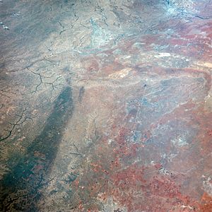
Summers here have many clear, sunny days. Winter nights often drop below freezing (32°F or 0°C). The wettest months are April and May. This region is part of Tornado Alley, so tornadoes are common in late spring. They happen when winds from the west and south meet. In the 1930s, poor land use and strong winds caused huge dust storms, known as the Dust Bowl. Today, better farming methods help prevent this. The Panhandle, being furthest from the Gulf, has colder winters with occasional Arctic blasts that bring very cold and snowy weather.
Trans-Pecos Region
The Trans-Pecos region, also called Big Bend Country, is in western Texas. It's mostly the Chihuahuan Desert with some mountains. This area has the most clear, sunny days in the state during fall, winter, and spring. It's also the driest, getting only about 16 inches (406 mm) of rain or less each year.
Snow is rare in the lower areas, but the highest mountain peaks can get heavy snow in winter. The dry climate causes the land to become more like a desert, and too much animal grazing makes this worse. In the mountains, you can find coniferous forests (like pine trees) where it's wetter and cooler. The wettest months here are in the summer. Winds are strong as they blow through canyons and valleys. In flatter areas, these strong winds are used to create electricity.
Hill Country
| City | Jan | Feb | Mar | Apr | May | Jun | Jul | Aug | Sep | Oct | Nov | Dec |
|---|---|---|---|---|---|---|---|---|---|---|---|---|
| Austin | 60/40 | 65/44 | 73/51 | 79/58 | 85/65 | 91/71 | 95/73 | 96/73 | 90/69 | 81/60 | 70/49 | 62/42 |
| San Antonio | 62/39 | 67/43 | 74/50 | 80/57 | 86/66 | 91/72 | 95/74 | 95/74 | 90/69 | 82/59 | 71/49 | 64/41 |
| Waco | 57/33 | 62/38 | 70/46 | 78/53 | 84/63 | 91/70 | 96/74 | 96/73 | 90/66 | 79/57 | 68/45 | 59/36 |
The Texas Hill Country, or central Texas, is known for its many rivers and hills. The climate is semi-dry in the west and more humid in the east and south. Both areas have hot summers and mild winters, with some cold spells. It can be very humid during the warm season.
The plants here include both broadleaf evergreen (trees that stay green all year) and deciduous (trees that lose their leaves) trees near rivers. Dry grasslands and open woodlands are common in the northwest, while thicker woodlands and moister grasslands are found in the east and south. This region can get a lot of rain in one year (up to 48 inches or 1219 mm), leading to floods near rivers. But in drier years, it might only get 12 inches (305 mm). On average, it gets 21 to 35 inches (533 to 889 mm) of rain annually. April and May are the wettest months.
Piney Woods
| City | Jan | Feb | Mar | Apr | May | Jun | Jul | Aug | Sep | Oct | Nov | Dec |
|---|---|---|---|---|---|---|---|---|---|---|---|---|
| Dallas | 55/36 | 61/41 | 69/49 | 77/56 | 84/65 | 92/73 | 96/77 | 96/76 | 89/69 | 79/58 | 66/47 | 57/39 |
| Fort Worth | 55/34 | 61/40 | 68/47 | 76/54 | 83/61 | 91/69 | 97/74 | 96/74 | 89/65 | 79/55 | 67/44 | 58/35 |
| Galveston | 62/50 | 64/52 | 70/58 | 75/65 | 81/72 | 87/78 | 89/80 | 89/79 | 87/76 | 80/68 | 71/59 | 64/52 |
| Houston | 63/45 | 67/48 | 74/55 | 79/61 | 86/68 | 91/74 | 94/75 | 93/75 | 89/72 | 82/62 | 73/53 | 65/47 |
| Port Arthur | 61/43 | 65/46 | 72/52 | 78/59 | 84/66 | 89/72 | 92/74 | 92/73 | 88/69 | 80/60 | 71/51 | 64/45 |
The Piney Woods is the eastern part of Texas and has a humid subtropical climate. It gets the most rain, over 60 inches (1524 mm) annually in the far east. This is because humid air from the Gulf of Mexico moves into the area and causes rain. Coastal areas are often cloudy, but northern parts are sunniest in summer.
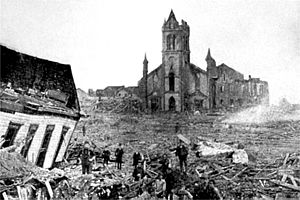
April and May are the wettest months. This area often has severe thunderstorms and tornadoes, especially in spring. Hurricanes also hit this region. The Galveston Hurricane of 1900 was one of the worst, and more recently, Hurricane Rita caused a lot of damage. The high humidity makes summer heat feel even hotter. Along the coast, temperatures stay cooler in winter and spring because of the cool Gulf waters. Thick fog can form in February and March, sometimes stopping ships for days.
South Texas
| City | Jan | Feb | Mar | Apr | May | Jun | Jul | Aug | Sep | Oct | Nov | Dec |
|---|---|---|---|---|---|---|---|---|---|---|---|---|
| Brownsville | 69/50 | 72/53 | 78/59 | 82/65 | 87/72 | 91/75 | 92/75 | 93/75 | 89/73 | 84/66 | 77/59 | 70/52 |
| Corpus Christi | 66/46 | 70/49 | 76/56 | 81/62 | 86/69 | 90/74 | 93/74 | 93/75 | 90/72 | 84/64 | 75/55 | 68/48 |
| Del Rio | 63/40 | 68/44 | 76/52 | 83/59 | 89/67 | 94/72 | 96/74 | 96/74 | 91/69 | 82/61 | 71/49 | 63/41 |
| Laredo | 68/44 | 73/48 | 82/56 | 89/63 | 95/70 | 100/74 | 102/75 | 99/75 | 93/71 | 86/63 | 76/53 | 68/45 |
| Victoria | 63/44 | 67/47 | 73/54 | 79/60 | 85/68 | 90/73 | 93/75 | 94/75 | 90/70 | 83/62 | 73/52 | 65/45 |
South Texas includes dry ranch land and the wetter Rio Grande Valley. The inland areas get similar rainfall to the Northern Plains. Coastal areas are warm most of the year because of currents from the Gulf of Mexico. Summers are hot and humid.
The coast gets more rain than inland areas, and subtropical forests grow along the Rio Grande. April and May are the wettest months in western South Texas. But near the Gulf Coast, September is the wettest month because of tropical storms and hurricanes. These storms can bring huge amounts of rain, like 5 to 10 inches (127 to 254 mm) in just a day or two. Inland, where it's drier, you'll see ranches with thick, thorny bushes and grasslands. Winters are usually mild. Snow is rare because there isn't much humidity in winter. Summers are mostly hot and dry, but can be humid when winds come from the Gulf. Tornadoes can happen, but they are less common here than in other parts of Texas.
The very southern tip of Texas is almost tropical. In years with warmer temperatures, you can see many tropical plants in the lower Rio Grande Valley, like in a tropical savanna climate.
Cold Weather and Snow
Northern and western parts of Texas get snow every year because their winters are colder. In February 1956, a huge snowstorm hit northern Texas. Vega got 24 inches (61 cm) of snow in one day, and Plainview got 24 inches (61 cm) in one day. El Paso in Far West Texas got 22.4 inches (57 cm) of snow in 24 hours in December 1987.
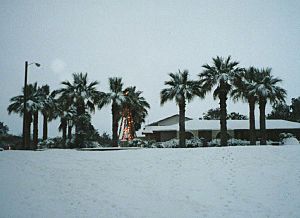
For central and southern Texas, snow is much rarer. In February 1895, a large part of southeastern Texas got over 12 inches (30 cm) of snow, with nearly 30 inches (76 cm) in Port Arthur. More recently, around Christmas 2004, up to 13 inches (33 cm) of snow fell along the middle coast, with the most in Victoria.
One of the worst cold spells for the whole state happened in December 1983. Several places had record-long periods of temperatures at or below freezing (32°F or 0°C). Lubbock stayed below freezing for 9 days (207 hours). The Dallas-Fort Worth airport was below freezing for 12 days (296 hours). Snow that fell in mid-December stayed on the ground until New Year's Day 1984.
February 2021 also brought a record-breaking cold snap. In Austin, temperatures stayed at or below freezing for 7 days (168 hours). In Abilene, it was below freezing for 10 days (252 hours). Central Texas, including Waco, Bryan, and Killeen, had a new record of 9 days (205 hours) at or below freezing. San Angelo had 6 days (152 hours) of freezing temperatures.
Severe Weather
Thunderstorms are very common in Texas, especially in the eastern and northern parts. Texas is part of Tornado Alley, a region where tornadoes happen often. The state experiences the most tornadoes in the U.S., with an average of 139 each year. These usually hit North Texas and the Panhandle most often, usually in April, May, and June.
Hurricanes
Texas is located at the northwestern end of the Gulf of Mexico, which makes it open to hurricanes. Some of the most damaging hurricanes in U.S. history have hit Texas. A hurricane in 1875 killed about 400 people in Indianola. Then, another hurricane in 1886 destroyed the town completely. This allowed Galveston to become the main port city. However, Galveston was then devastated by a hurricane in 1900 that killed about 8,000 people (and possibly up to 12,000), making it the deadliest natural disaster in U.S. history.
Other major Texas hurricanes include Hurricane Carla in 1961, Hurricane Beulah in 1967, Hurricane Alicia in 1983, Hurricane Rita in 2005, Hurricane Ike in 2008, and Hurricane Harvey in 2017.
The areas where hurricanes are most likely to hit in Texas seem to be changing. In the early 1980s, the middle coast was the most common target. But since the 1960s, that area has been hit less often. Recent studies show that the upper coast of Texas has been the most common place for hurricanes to make landfall since 1851.
Flooding
The biggest danger from tropical storms for Texans is flooding. It's interesting that weaker tropical storms can sometimes cause more heavy rain and terrible flooding than stronger ones. Storms that spread out a lot, like Hurricane Beulah, also tend to bring a lot of rain. Slow-moving storms, such as Tropical Storm Amelia (1978) and Hurricane Harvey (2017), can also cause huge amounts of rain.
Tropical storms from both the eastern Pacific and Atlantic Oceans can affect Texas. Flooding in Texas is generally more common in spring and early autumn. It can also happen when weather fronts get stuck and interact with strong upper-level storms. The most likely place for floods in Texas is the Balcones Escarpment. This is an area in central Texas where the land suddenly changes elevation, between the Edwards Plateau and the coastal plain.
Extreme Temperatures
The highest temperature ever recorded in Texas was 120°F (49°C). This happened on August 12, 1936, in Seymour, and again on June 28, 1994, in Monahans. The lowest temperature ever recorded in Texas was -23°F (-31°C), on February 8, 1933, in Seminole.
| Climate data for Texas | |||||||||||||
|---|---|---|---|---|---|---|---|---|---|---|---|---|---|
| Month | Jan | Feb | Mar | Apr | May | Jun | Jul | Aug | Sep | Oct | Nov | Dec | Year |
| Record high °F (°C) | 98 (37) |
104 (40) |
108 (42) |
113 (45) |
116 (47) |
120 (49) |
119 (48) |
120 (49) |
116 (47) |
110 (43) |
102 (39) |
98 (37) |
120 (49) |
| Record low °F (°C) | −22 (−30) |
−23 (−31) |
−12 (−24) |
5 (−15) |
15 (−9) |
32 (0) |
40 (4) |
39 (4) |
25 (−4) |
8 (−13) |
−10 (−23) |
−16 (−27) |
−23 (−31) |
El Niño and La Niña
The El Niño–Southern Oscillation (ENSO) cycle greatly affects Texas weather. During the El Niño phase, a strong air current called the jet stream moves across the southern U.S. This means Texas winters are colder and get more snow than usual. Texas is also less likely to be hit by hurricanes during El Niño because of increased winds that break up storms in the Atlantic. Spring and early summer bring more rain, especially when a low-pressure system is over the Four Corners region or northern Mexico, causing monsoon-like weather.
During the opposite phase, La Niña, the jet stream is much further north. This makes winters milder and drier than normal. Hurricanes are more likely to hit Texas during La Niña because there are fewer winds to break them up in the Atlantic. Droughts in Texas are much more likely during La Niña. For example, the 2010-2011 La Niña caused one of the worst droughts in Texas history.
Climate Change
The climate in Texas is changing. This is partly because of global warming and more greenhouse gases being released. By 2016, most of Texas had already gotten about 1.5 degrees Fahrenheit warmer. This warming is due to greenhouse gases from the United States and other countries.
Texas is expected to face many environmental changes from climate change in the United States. These include rising sea levels, more frequent extreme weather events, and less water resources.
Texas had a fast-growing economy in 2020. A lot of this growth came from making traditional energy sources like oil and natural gas.
Even though Texas has a long history of producing oil and natural gas, renewable energy is growing fast. More jobs in solar energy have appeared. Also, wind farms have been built in West Texas. Texas has a lot of sunshine, flat land, and a good business environment. This means it has great potential to develop more renewable energy in the future.
Many cities in Texas are also taking action. For example, Austin, Houston, Dallas, and San Antonio have started Climate Action Plans. Government groups also have programs like the Texas Emissions Reduction Plan. They also have the Innovative Energy Demonstration Program. These programs help promote renewable energy and climate education in Texas. | Sharif Bey |
 | Hale Woodruff |
 | Richmond Barthé |
 | Purvis Young |


