Cowans Gap State Park facts for kids
Quick facts for kids Cowans Gap State Park |
|
|---|---|
|
IUCN Category III (Natural Monument)
|
|

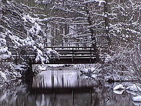
A snow-covered bridge at Cowans Gap State Park
|
|
| Location | Pennsylvania, United States |
| Area | 1,085 acres (4.39 km2) |
| Elevation | 1,204 ft (367 m) |
| Established | 1937 |
| Named for | John and Mary Cowan |
| Governing body | Pennsylvania Department of Conservation and Natural Resources |
| Website | Cowans Gap State Park |
Cowans Gap State Park is a fun place to visit in Pennsylvania, USA! It covers about 1,085-acre (439 ha) of land. You can find it in Fulton and Franklin Counties. The park is mostly surrounded by the Buchanan State Forest. It's a great spot for outdoor adventures.
Contents
Park History: A Look Back in Time
Early Times: French and Indian War
The story of Cowans Gap State Park goes way back to the French and Indian War. This was a big fight between the British and the French. Both sides wanted control of the land, especially the Ohio River Valley. Native American tribes were allies with both sides.
During this time, important roads were built through the area. General Edward Braddock led British soldiers in 1755. His men built Braddock's Road. Colonel James Burd also built Burd's Road to help move supplies. This road even passed through Cowans Gap!
Later, in 1758, General John Forbes led another British effort. His team built the Forbes Road. This road helped the British take control of Western Pennsylvania.
The Cowan Family's Story
Cowans Gap is named after John and Mary Cowan. They settled here right after the American Revolution. John was from a family who supported the British (called Loyalists). Mary was from a family who supported the American side (called Patriots).
They met in Boston in 1775. John was a Major in the British Army. After the war, he wanted to marry Mary. Her family said no, so John and Mary eloped!
They first lived in Chambersburg. Then, they decided to move to Kentucky. But their wagon broke near Fort Loudoun. John traded his horses and broken wagon to a Tuscarora chief for the land that is now Cowans Gap.
The chief gave John a smoking pipe and "tomahawk rights." This meant John marked a large chestnut tree with three slashes. It was a sign of peace with the Tuscarora people. John officially got the land deed in 1785. The Cowans built their home near where the Forbes Road passed through.
Forests and Fires
For a long time, the forests around Cowans Gap were cut down. This happened in the late 1700s and early 1800s. People needed charcoal for iron furnaces nearby. Colliers (people who made charcoal) cut down trees like white pine and hardwoods. They stacked the wood and burned it slowly to make charcoal.
The forests grew back, but then more trees were cut down for another iron furnace in 1865. By 1907, almost all the trees were gone. What was left were dry tree tops. Sparks from steam locomotives often started huge wildfires. These fires burned everything to ashes.
Building the Park: Civilian Conservation Corps
After all the fires, a huge effort began to plant new trees. This happened during the Great Depression. President Franklin D. Roosevelt started the Civilian Conservation Corps (CCC). This program gave jobs to young, unemployed men across the United States.
A CCC camp was built at Cowans Gap. The young men first lived in tents. Soon, they built cabins, which you can still use today! The CCC planted thousands of new trees. They also built four bridges, 30 miles (48 km) of state roads, and 32 miles (51 km) of fire trails. They even built 11 miles (18 km) of telephone lines.
The CCC also cleared brush from the forests and streams. They built pavilions and the dam that created Cowans Gap Lake. Thanks to their hard work, Cowans Gap State Park opened to the public in 1937.
Fun Activities at Cowans Gap State Park
Cowans Gap State Park is open all year for fun! You can have picnics around Cowans Gap Lake. People also enjoy hiking, cross-country skiing, hunting, fishing, ice fishing, ice skating, and boating.
Hiking Trails
The park has about 10 miles (16 km) of trails for hiking. Some are also good for cross-country skiing in winter.
- Cameron Trail (0.5 miles (800 m)): This is a "difficult" trail. It goes along the park's southern edge and ends on top of Cove Mountain.
- Geyer Trail (0.5 miles (800 m)): Another "difficult" trail. It starts near the dam on Cowans Gap Lake and climbs Tuscarora Mountain. You'll see patches of mountain laurel here.
- Logging Road Trail (1.7 miles (2.7 km)): This is an "easy" trail. It goes around the base of Cove Mountain and connects to other trails. It's popular for cross-country skiing.
- Horseshoe Trail (0.6 miles (970 m)): A "very difficult" trail for experienced hikers. It's very steep with loose rocks as it climbs Cove Mountain.
- Knobsville Road Trail (1.3 miles (2.1 km)): This is a "moderate" trail. It follows an old road built by the CCC. It also goes up Cove Mountain. You can see an old landslide exhibit and a CCC-built incinerator. This trail leads to a great park overlook.
- One Mile Trail (0.4-mile (640 m)): Don't let the name fool you, it's not one mile long! It's an "easy" trail. It's called "One Mile Trail" because it's one mile from Parking Lot #3.
- Plessinger Trail (1.1 miles (1.8 km)): A "moderate" and rocky trail. It follows Little Aughwick Creek, which is great for fishermen.
- Ski Trail (0.2 miles (320 m)): An "easy" short trail. It connects Parking Lot #7 to the Logging Road Trail.
- Three Mile Trail (1.1 miles (1.8 km)): This trail is also not three miles long! It's a "moderate" trail. It's called "Three Mile Trail" because it's three miles down Aughwick Road from Parking Lot #3. It passes through pretty mountain laurel patches.
- Tuscarora Trail: This trail is a branch of the famous Appalachian Trail. About 2 miles (3.2 km) of it passes through Cowans Gap State Park.
- Forbes Trail: A longer backpacking trail that goes across southern Pennsylvania. It passes through Cowans Gap State Park. Most people using this trail are long-distance backpackers.
Cowans Gap Lake
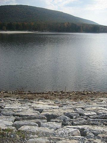
Cowans Gap Lake is 42 acres (17 ha) big. The CCC created it during the Great Depression by building a dam on Little Aughwick Creek. The lake is open for fishing, swimming, and boating. In winter, you can go ice skating and ice fishing. Be careful in winter, as the park staff only checks ice thickness in the ice skating area.
Fishermen can catch trout, bass, panfish, and perch in the lake. Little Aughwick Creek is also a good spot for trout. Always follow the rules from the Pennsylvania Fish and Boat Commission.
The beach is open from 11:00 am to 7:00 pm. There are no lifeguards, so swim at your own risk. A food stand at the beach sells yummy snacks like pizza, funnel cake, french fries, and ice cream.
You cannot use gas-powered boats on Cowans Gap Lake. Electric-powered and non-powered boats need to be registered. During summer, you can rent row and paddle boats at the lake.
Hunting
About 630 acres (250 ha) of the park's woods are open for hunting. Hunters must follow the rules of the Pennsylvania Game Commission. Common animals to hunt include squirrels, white-tailed deer, and turkeys. Hunting groundhogs is not allowed. Hunters can also reach the nearby Buchanan State Forest from the park's parking lots.
Staying Overnight at the Park
Camping
The campground at Cowans Gap State Park is open from mid-April (for trout season) to mid-December (after deer season). There are 224 campsites. They can fit anything from a small tent to a large RV. The campground has modern restrooms with flush toilets and hot showers. There's also a special area for large groups, like the Boy Scouts.
Cabins
You can also stay in one of the 10 rustic cabins. The CCC built these cabins during the Great Depression. Each cabin has three rooms and can sleep four people. They have a refrigerator, stove, fireplace, and two bunk beds. They don't have indoor plumbing, but there's a modern restroom with hot showers nearby.
Nearby State Parks to Explore
Here are some other state parks within 30 miles (48 km) of Cowans Gap State Park:
- Big Spring State Forest Picnic Area (Perry County)
- Buchanan's Birthplace State Park (Franklin County)
- Mont Alto State Park (Franklin County)
- Caledonia State Park (Adams and Franklin Counties)
- Fort Frederick State Park (Maryland)
- Fowlers Hollow State Park (Perry County)
- South Mountain State Park (Maryland)
- Trough Creek State Park (Huntingdon County)
- Warriors Path State Park (Bedford County)
 | DeHart Hubbard |
 | Wilma Rudolph |
 | Jesse Owens |
 | Jackie Joyner-Kersee |
 | Major Taylor |


