
Department of Ancash facts for kids
Quick facts for kids
Department of Ancash
|
|||
|---|---|---|---|

Cordillera Blanca and Cordillera Negra in the Department of Ancash
|
|||
|
|||
.svg) |
|||
| Country | Peru | ||
| Subdivisions | 20 provinces and 166 districts | ||
| Largest city | Chimbote | ||
| Capital | Huaraz | ||
| Area | |||
| • Total | 35,914.41 km2 (13,866.63 sq mi) | ||
| Elevation
(Capital)
|
3,052 m (10,013 ft) | ||
| Highest elevation | 6,768 m (22,205 ft) | ||
| Lowest elevation | 0 m (0 ft) | ||
| Population
(2017)
|
|||
| • Total | 1,083,519 | ||
| • Density | 30.169478/km2 (78.13859/sq mi) | ||
| UBIGEO |
02
|
||
| Dialing code | 043 | ||
| ISO 3166 code | PE-ANC | ||
| Poverty rate | 21.5% | ||
| Percentage of Peru's GDP | 2.76% | ||


Ancash (Quechua: Anqash; Spanish: Áncash) is a beautiful and diverse region in western Peru. It's known for its amazing mountains, deep valleys, and sandy beaches. Ancash shares borders with other Peruvian regions like La Libertad to the north, Huánuco and Pasco to the east, and Lima to the south. To its west, you'll find the vast Pacific Ocean.
The capital city of Ancash is Huaraz, which is nestled high in the Andes mountains. The largest city and a very important port is Chimbote, located on the coast. The name "Ancash" comes from the Quechua word anqash, which can mean 'light' or 'blue', or even 'eagle'.
Contents
- Discovering Ancash: Geography and Nature
- Ancash Through Time: A Brief History
- How Ancash is Organized: Political Divisions
- Ancash's Economy
- People and Culture: Demographics
- Place Names: Toponyms
- Exploring Ancash: Tourism
- Famous Mountains and Ancient Sites
- Popular Tours in Ancash
- Traveling the Pativilca-Caraz-Huallanca Route
- The Majestic Cordillera Blanca
- Huascarán National Park: A Natural Treasure
- The Cordillera Negra: A Shield for the White Mountains
- Exciting Extreme Sports in Ancash
- The Santa River and Cañón del Pato
- The Beautiful Callejón de Conchucos
- Getting Around: Transportation
- Quick Facts About Ancash
- Famous People From Ancash
- Images for kids
- See also
Discovering Ancash: Geography and Nature

Ancash is a land of incredible contrasts. You can find high mountains with snowy peaks and deep valleys, as well as long sandy beaches by the Pacific Ocean. The western part of Ancash has steep slopes that form narrow canyons.
The region is crossed by two major mountain ranges. To the west is the Cordillera Negra (Black Mountain Range), which has peaks without glaciers. To the east is the Cordillera Blanca (White Mountain Range), famous for its many peaks covered in snow and ice. These include the towering Huascarán and the beautiful Alpamayo.
Between these two mountain ranges, the Santa River flows through a valley called the Callejón de Huaylas. This valley becomes very narrow in one spot, forming the Cañón del Pato (Duck Canyon).
Peru's Highest Peak: Huascarán
The snow-covered peak of Huascarán is the highest mountain in Peru. It's also the second highest in all of the Americas, reaching an amazing height of 6,768 meters (22,205 feet). This giant mountain stands tall above the deep ocean trough of Chimbote, which is 6,263 meters (20,548 feet) deep! Many lakes, like Llanganuco Lakes and Lake Parón, were formed by ancient glaciers.
The Pacific Coast and Ocean Currents
The coast of Ancash is greatly influenced by the Pacific Ocean. Two important currents, the Humboldt Current (also called the Peruvian current) and the El Niño current, have a big impact on the region.
Normally, the Humboldt Current brings cold water, which is full of fish. This makes Ancash a great place for fishing, especially for anchoveta. In the 1950s, Chimbote was even the world's top fishing port!
However, when warmer waters from the north, like the El Niño current, arrive, they can cause heavy rains on the coast. This makes the anchoveta disappear, which affects fishing. The rivers can also flood, causing damage to land and cities. It's hard to predict when these currents will change.
Islands and Beaches
Along the northern coast of Ancash, you'll see many islands and islets. Most of these are home to guano seabirds. Some important islands are Tortuga Island, La Viuda Island, Isla Blanca, and Santa Island.
The coastal region also has many peninsulas, small inlets, warm bays, and colorful sand beaches. Many of these are hard to reach by land. Some popular beaches include Grande Beach, La Gramita Beach, and Las Salinas Beach. Much of this coast is a long stretch of sandy desert, which is common in Peru's coastal areas due to the Humboldt Current.
Rivers of the Coast
Green valleys, where crops like sugarcane, rice, and cotton are grown, can be found along the rivers. The main rivers on the Ancash coast are the Huarmey, Culebras, Casma, Sechín, Nepeña, Lacramarca, and Santa.
The Santa River is special because it has water all year round, fed by glaciers and lakes in the Cordillera Blanca. Most other rivers on the Peruvian coast only have water when it rains in the highlands or when El Niño brings more water.
Ancash Through Time: A Brief History

Around 400 to 600 BC, the very first Peruvian civilization, called Chavín, began and grew in this area. This culture is very important because it influenced many other cultures in the Andean and Amazonian regions. The archaeologist Julio C. Tello believed that Chavín was the "mother of all the cultures" that later developed in ancient Peru. The name Chavín comes from the Quechua word Chawpin, meaning 'center' or 'headquarters'.
Later, during the Inca Empire, the people living in the Santa valley became part of the Inca empire under Pachacuti.
When the first Spaniards arrived, they were drawn to the area by its rich silver veins. Over time, the Spanish built new cities where Inca ones once stood. This is how Jerónimo de Alvarado founded the city of Huaraz. Huaraz became important during the time of Simón Bolívar, who used it as a base to help free Peru.
The department of Ancash was officially created after a big battle in 1839, which ended a conflict called the Peru-Bolivia Confederation.
In 1970, a terrible earthquake hit Ancash. It caused a lot of damage and sadly, more than 50,000 people lost their lives. It was one of the deadliest natural disasters in Peru's history.
Today, most people in Ancash live in the Callejón de Huaylas valley. Since 2011, there have been protests in the region about mining. People are concerned about water pollution and who controls the natural resources.
How Ancash is Organized: Political Divisions
Ancash is divided into 20 provinces. These provinces are then split into 166 smaller areas called districts. The capital city of Ancash is Huaraz. Here are the provinces and their capital cities:
| Province | Capital | Districts |
|---|---|---|
| Aija | Aija | 5 |
| Antonio Raymondi | Llamellín | 6 |
| Asunción | Chacas | 2 |
| Bolognesi | Chiquián | 15 |
| Carhuaz | Carhuaz | 11 |
| Carlos F. Fitzcarrald | San Luis | 3 |
| Casma | Casma | 4 |
| Corongo | Corongo | 7 |
| Huaraz | Huaraz | 12 |
| Huari | Huari | 16 |
| Huarmey | Huarmey | 5 |
| Huaylas | Caraz | 10 |
| Mariscal Luzuriaga | Piscobamba | 8 |
| Ocros | Orcos | 10 |
| Pallasca | Cabana | 11 |
| Pomabamba | Pomabamba | 4 |
| Recuay | Recuay | 10 |
| Santa | Chimbote | 9 |
| Sihuas | Sihuas | 10 |
| Yungay | Yungay | 8 |
Ancash's Economy
Ancash has the third largest economy in Peru. A big part of its economy comes from mining for gold, copper, and zinc. The coast is also very rich in fish, making Ancash the most productive fishing region in Peru. Peru is actually the world's largest exporter of fish meal. Farmers in Ancash grow crops like potatoes, wheat, and barley.
People and Culture: Demographics
Most people in Ancash speak Spanish as their first language (about 68%). However, a significant number (about 31%) speak Quechua, specifically the Ancash Quechua variety.
Languages Spoken in Ancash
Here's a look at the main languages spoken in Ancash:
| Province | Quechua | Spanish | Total |
|---|---|---|---|
| Aija | 2,807 | 4,623 | 7,445 |
| Antonio Raymondi | 12,073 | 3,694 | 15,842 |
| Asunción | 6,854 | 1,564 | 8,508 |
| Bolognesi | 4,473 | 24,374 | 28,998 |
| Carhuaz | 30,365 | 10,971 | 41,444 |
| C.F Fitzcarrald | 17,956 | 1,709 | 19,761 |
| Casma | 5,517 | 34,299 | 39,908 |
| Corongo | 745 | 7,128 | 7,889 |
| Huaraz | 50,570 | 88,410 | 139,377 |
| Huari | 45,830 | 12,619 | 58,721 |
| Huarmey | 1,695 | 24,521 | 26,251 |
| Huaylas | 28,772 | 21,422 | 50,297 |
| M. Luzuriaga | 19,687 | 1,841 | 21,645 |
| Ocros | 734 | 7,932 | 8,686 |
| Pallasca | 84 | 26,958 | 27,147 |
| Pomabamba | 22,061 | 3,875 | 26,007 |
| Recuay | 6,587 | 11,450 | 18,084 |
| Santa | 9,005 | 365,507 | 375,430 |
| Sihuas | 10,520 | 17,965 | 28,564 |
| Yungay | 37,806 | 13,678 | 51,656 |
| Total | 314,141 | 684,540 | 1,001,660 |
| % | 31.36 | 68.34 | 100.00 |
Who Lives in Ancash? Ethnicity
Ethnicity in Ancash (2017) Mestizo (54.9%) Quechua (35.3%) White People (5.9%) Afro-Peruvian (3.2%) Other (0.7%)
Most people in Ancash identify as Mestizo (a mix of European and Indigenous heritage) or Quechua (Indigenous people).
Religion in Ancash
Most people in Ancash are Catholic (about 77%). A smaller group (about 15.5%) are Evangelical.
Education: Literacy Rates
As of 2017, most of the population in Ancash (about 85%) can read and write.
Place Names: Toponyms
Many place names in Ancash come from the Quechua language. In areas like the Cordillera Blanca, you'll find many names with Quechua origins. The Peruvian government is working to make sure these names are spelled correctly using the original indigenous alphabets on official maps and signs.
Exploring Ancash: Tourism


The Callejón de Huaylas, in the middle of Ancash, is a very popular place for tourists. It has many natural sights, places for sports, and ancient ruins from old cultures. The Cordillera Blanca is a huge draw for visitors who want to see its glaciers, valleys, lakes, and hot springs. Ancash is sometimes called the "Switzerland of Peru" because of its stunning mountains.
Famous Mountains and Ancient Sites
You can see the four-mile-high Huascarán, which is part of the Huascarán National Park. The Alpamayo peak is also here, and it's considered one of the most beautiful mountains in the world!
Ancash also has many interesting archaeological sites from ancient cultures. These include the Guitarrero Cave (which is about 12,000 years old!), the pre-Columbian ruins of Chavín de Huantar, Hunsakay, Willkawayin, Sechín, and Pañamarka.
Popular Tours in Ancash
There are several tours that let you explore the main tourist and historical spots in Ancash:
- Huaraz – Recuay – Catac – Pachaqutu ravine and Pastururi.
- Yungay – Llankanuku – Vaquería – Waripampa – Santa Cruz and Caraz.
- Caraz, Cañon del Pato.
- Huaraz – Pitiq – Qillqay and Juanca.
- Caraz, Puya Raimondi at Mirador de Huinchus.
- Huaraz – Olleros – Yanashallash – Chavín de Huantar – Qiruqucha and Catac.
- Caraz, Parun Lake.
- Catac and Carpa.
- Huaraz – Willkawayin and Llaqa ravine.
- Chacas – Perlilla.
- Chacas – Huari.
Traveling the Pativilca-Caraz-Huallanca Route
The historic village of Pativilca in the Lima Region is where Simón Bolívar planned his journey to free Peru. It's about 202 kilometers (126 miles) north of Lima. From here, a paved highway leads to the Callejón de Huaylas. This road often needs repairs because of flash floods and heavy rains, which is common for mountain roads in Peru.
The highway is 287 kilometers (178 miles) long and offers a comfortable ride. It climbs steeply through the Cordillera Negra (Black Range) up to the top of Conococha, which is 4,100 meters (13,451 feet) above sea level. From there, the road goes down into the Callejón de Huaylas. The trip from Lima to Huaraz and then to Caraz takes about seven to eight hours by car or bus.
As you leave Pativilca, the highway passes through wide fields of sugarcane for about 20 kilometers (12 miles), following the Fortaleza River. When you reach the town of Huaricanga, you enter the Ancash region. The road then slowly climbs the first hills of the Cordillera Negra for about 50 kilometers (31 miles). The climb gets much steeper past the towns of Chasquitambo and Chaucayán, with many twists and turns.
The Majestic Cordillera Blanca

This mountain range is made of giant, snow-covered peaks that are considered some of the most beautiful in the world. The White Mountain Range is the highest tropical mountain range globally. It runs along the east side of the Callejón de Huaylas and is about 180 kilometers (112 miles) long.
It has 35 peaks that are taller than 6,000 meters (19,685 feet), plus many smaller ones. These mountains offer different levels of challenge for climbers. It's called the "White" mountain range not just because of its snow, but also because of the white rocks it's made of. Huascarán, the highest peak in Peru, reaches 6,768 meters (22,205 feet).
Alpamayo, at 5,947 meters (19,511 feet), is known as "the most beautiful snow mountain in the world." This title was given after a photo of Alpamayo won a world contest in Germany in 1966. Other notable peaks include Huandoy N (6,395 m), Huantsán (6,410 m), Chopicalqui (6,354 m), Copa N (6,173 m), Artesonraju (6,025 m), Santa Cruz S (6,259 m), and Hualcán (6,126 m).
The beauty of the Cordillera Blanca is also helped by the Cordillera Negra. The Cordillera Negra acts like a shield, blocking strong winds from the Pacific Ocean. This helps prevent the large glaciers of the Cordillera Blanca from melting too quickly.
Huascarán National Park: A Natural Treasure

Huascarán National Park is one of Peru's most amazing conservation areas. It's filled with stunning peaks, lakes, canyons, rivers, and waterfalls. Inside the park, you can see the entire Cordillera Blanca and seven peaks over 6,000 meters (19,685 feet) tall. This makes it a top spot for climbers and mountaineers from all over the world.
The park was created on July 1, 1975, and covers 340,000 hectares (840,000 acres). It includes parts of many provinces in Ancash. UNESCO has also named it a biosphere reservation and a World Heritage Site.
The park's land is very uneven, with snowy peaks ranging from 5,000 to 6,768 meters (16,404 to 22,205 feet) above sea level. It also has deep valleys carved by ancient glaciers and many lakes. There are 663 glaciers within the park's borders.
The climate in the park has two clear seasons: a dry season from April to September (driest in June-August) and a wet season from October to May (rainiest in January-March).
The park is home to a huge variety of plants, including the unique and giant Puya raimondii. You can also find many animals like tarucas (Andean deer), spectacled bears, vicuñas, pumas, foxes, vizcachas, weasels, Andean mountain cats, opossums, and hog-nosed skunks. Many birds, such as ducks, American coots, and hummingbirds, also live here.
The Cordillera Negra: A Shield for the White Mountains

The road from Casma to Huaraz is not very busy. It starts paved but then becomes an unpaved path that climbs the sides of the Cordillera Negra, following the Casma River. This route gets steeper as it approaches Pariacoto. There aren't many big towns along this road, except for Pira, which offers some services for travelers.
This very steep and narrow road winds between large cliffs and valleys. You'll see small farming villages with fields of potatoes, wheat, barley, and other foods. There's also a lot of livestock and human activity.
The valleys of the Cordillera Negra, which runs parallel to the Cordillera Blanca for 150 kilometers (93 miles), are often dark and dry. Some hills in this range include Rumicruz (5,020 m), Rocarre (5,187 m), Cerro Rico (5,015 m), and Chunta (4,810 m).
The Cordillera Negra is very important for the beauty of the Cordillera Blanca. It acts like a shield, softening the winds from the Pacific Ocean and preventing the large glaciers of the Cordillera Blanca from melting. The Cordillera Negra has rocky peaks with very little winter snow, reaching a maximum height of 5,500 meters (18,045 feet). Its name comes from the contrast with the white, snowy peaks of the Cordillera Blanca.
Exciting Extreme Sports in Ancash
The Callejón de Huaylas and Huascarán National Park are perfect for extreme sports:
- Mountaineering: The glaciers of the Cordillera Blanca are some of the best places in the world for ice climbing. You can climb all year, but the best weather is from May to September.
- Trekking: Ancient paths offer amazing opportunities for hiking all year. You can see diverse plants and animals, impressive snowy mountains, deep valleys, archaeological sites, and traditional villages. Hikes can last from one day to three weeks.
- Camping: Spending a night under the moonlight with only the stars and constellations like Capricornus and Crux for company is a wonderful experience. You can camp any time of year.
- Canoeing: The Santa River has different levels of rapids, making it great for river sports like canoeing and kayaking. The Llankanuku and Qiruqucha lakes are also good for boat rides.
- Cycling: Cyclists love riding on the highways and roads inside and outside Huascarán National Park. You can cycle all year. The area near Caraz has the best rides and downhill tracks.
- Rock climbing: The granite rocks around the Cordillera Blanca glaciers are perfect for rock climbing. There are walls from 100 to 1,000 meters (328 to 3,281 feet) high with many technical challenges. There's even a special climbing area called Rocódromo de Monterrey.
- Alpine skiing: You can ski down glaciers like Pastururi, Copa, Wallqan, Huascarán, Wallunarahu, and Perlilla. Perlilla is a newly discovered spot with 6 kilometers (3.7 miles) of slopes for skiing and snowboarding. These snowy mountains are also great for sliding on snow and building snowmen!
- Paragliding – Hang gliding: The Callejón de Huaylas has several spots perfect for these flying sports, available all year.
- Horse riding: Enjoy exciting rides on trails with Peruvian horses raised in the Callejón de Huaylas.
- Fishing: You can fish for trout with a rod in the rivers and lakes of the Cordillera Blanca and Cordillera Negra any time of year.
The Santa River and Cañón del Pato
From Chimbote to Huallanca, it's about 140 kilometers (87 miles). This unpaved road follows the path of an old railway line that was destroyed by the 1970 earthquake.
Outside Chimbote, the highway goes through the wide, flat, and fertile lands of the Santa valley, continuing to Huallanca. From Chuquicara, the highway gets narrower. The Chuquicara River, a major branch of the Santa River, has dark water because of coal sediments from the Pallasca mountains.
From Huallanca, you can travel through the Cañón del Pato. This is one of many canyons along the 370-kilometer (230-mile) Santa River. The Santa River starts at Lake Conococha and is the most important river on the coast. Over centuries, it has carved a narrow pass at 2,000 meters (6,562 feet) high in the Cordillera Negra.
In this area, the river water turns into whirlpools and rapids before flowing out of a narrow gorge called Cañón del Pato (Duck Canyon). This powerful waterfall is used to generate hydroelectric energy at the Cañón del Pato power station in Huallanca. From Huallanca, you can enter the Callejón de Huaylas or the Callejón de Conchucos (Conchucos valley).
The Beautiful Callejón de Conchucos
The Callejón de Conchucos is a lovely series of valleys located east of the Cordillera Blanca. A highway connects it from Catac to Huallanca.
Eight provinces of the Ancash Region are part of the Callejón de Conchucos. These are Huari, Asunción, Antonio Raymondi, Mariscal Luzuriaga, Pomabamba, Sihuas, Corongo, and Pallasca. This valley is on the other side of the Cordillera Blanca from the Callejón de Huaylas, before the Marañón River.
The land here has high peaks, deep valleys, and tough grasslands, making it a rugged area, like much of Peru's highlands. The northern provinces of Pallasca and Corongo have direct access to Chimbote and the Callejón de Huaylas. The other provinces have a main highway with two entry points, one from Huari Province and the other from Huallanca District and Sihuas Province, connecting Pomabamba, Mariscal Luzuriaga, and Antonio Raymondi provinces.
Getting Around: Transportation
Five main highways cross the Ancash region:
- The North Pan-American highway, which runs along the coast.
- Three east-west highways that connect the coast to the highlands, especially the Callejón de Huaylas:
- Pativilca – Huaraz – Caraz – Huallanca
- Nepeña – Pamparumas – Caraz
- Huarmey – Aija – Recuay
- Casma – Huaraz
- Chimbote – Huallanca – Caraz
- One highway that runs through the Callejón de Conchucos (Conchucos Alley) in the east of the Cordillera Blanca.
Ancash also has a network of smaller local roads.
Quick Facts About Ancash
| Weather | Warm and semitropical |
| Temperature | Annual average 16.2°C (61.2°F) |
| Road network | 4,429 km (2,752 miles) |
| Illiteracy rate | 14.7% |
| Child mortality rate | 43 per thousand |
| Distances |
|
Famous People From Ancash
- Santiago Antúnez de Mayolo: A famous physicist, engineer, and mathematician.
Images for kids
-
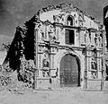
The church in Ocros, a town affected by the 1970 Ancash earthquake.

See also
 In Spanish: Departamento de Áncash para niños
- Tourism in Peru
