Macomb County, Michigan facts for kids
Quick facts for kids
Macomb County
|
||
|---|---|---|
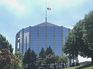
Macomb County Administration Building in Mt. Clemens
|
||
|
||
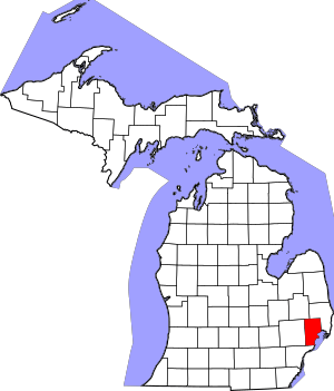
Location within the U.S. state of Michigan
|
||
 Michigan's location within the U.S. |
||
| Country | ||
| State | ||
| Founded | January 15, 1818 | |
| Named for | Alexander Macomb | |
| Seat | Mount Clemens | |
| Largest city | Warren | |
| Area | ||
| • Total | 571 sq mi (1,480 km2) | |
| • Land | 479 sq mi (1,240 km2) | |
| • Water | 92 sq mi (240 km2) 16%% | |
| Population
(2020)
|
||
| • Total | 881,217 | |
| • Estimate
(2023)
|
875,101 |
|
| • Density | 1,543.3/sq mi (595.9/km2) | |
| Time zone | UTC−5 (Eastern) | |
| • Summer (DST) | UTC−4 (EDT) | |
| Congressional districts | 9th, 10th | |
Macomb County (/məˈkoʊm/ MƏ-kohm) is a county located on the eastern side of Michigan. It is part of the Detroit area and has many northern suburbs. The main government office is in Mt. Clemens. The biggest city is Warren.
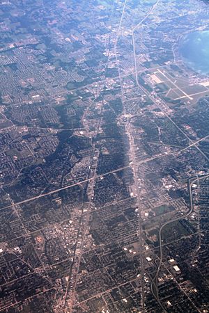
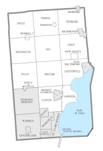
In 2020, about 881,217 people lived here. This makes Macomb County the third most populated county in Michigan. It is behind Wayne and Oakland counties. Macomb County has 27 cities, townships, and villages. Three of these are among the ten largest communities in Michigan. Most people live in the southern part of the county.
Contents
History of Macomb County
Early Settlers and Founding
For many centuries, the Ojibwe people lived in the area that is now Macomb County. They were here long before Europeans arrived. The first European settlers were French explorers and fur traders in the 1600s. They sometimes married Ojibwe women. Later, Moravian missionaries also settled here.
Macomb County was officially created on January 15, 1818. It was the third county formed in the Michigan Territory. The county was named after Alexander Macomb, Jr.. He was born in Detroit and was a hero in the War of 1812. He became the Commanding General of the U.S. Army in 1828.
Growth and Development
When Macomb County was first formed, it was much larger. As more people moved in, parts of it were used to create other counties. These included Oakland, Lapeer, Genesee, and St. Clair counties.
After World War II, Macomb County grew very quickly. Its population more than doubled between 1950 and 1960. Many people who worked in auto factories and other middle-class jobs moved to the county. In 2009, voters in Macomb County decided to have a County Executive. This person helps lead the county government.
Geography of Macomb County
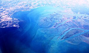
Macomb County covers about 571 square miles. About 479 square miles are land, and 92 square miles (16%) are water. The county's eastern border is Lake St. Clair. Across the lake to the southeast is Canada.
Most of Macomb County is considered part of Southeast Michigan. However, the far northern areas, like Richmond and Armada, are often seen as part of Michigan's Thumb region. The northern part of the county has many farms and rural areas. The southern part has a mix of suburban and city areas.
Neighboring Counties
Macomb County shares borders with several other counties:
- St. Clair County, Michigan - to the northeast
- Lapeer County, Michigan - to the northwest
- Oakland County, Michigan - to the west
- Wayne County, Michigan - to the south
- Lambton County, Ontario, Canada - across Lake St. Clair to the southeast
Population and People
| Historical population | |||
|---|---|---|---|
| Census | Pop. | %± | |
| 1810 | 580 | — | |
| 1820 | 898 | 54.8% | |
| 1830 | 2,413 | 168.7% | |
| 1840 | 9,716 | 302.7% | |
| 1850 | 15,530 | 59.8% | |
| 1860 | 22,843 | 47.1% | |
| 1870 | 27,616 | 20.9% | |
| 1880 | 31,627 | 14.5% | |
| 1890 | 31,813 | 0.6% | |
| 1900 | 33,244 | 4.5% | |
| 1910 | 32,606 | −1.9% | |
| 1920 | 38,103 | 16.9% | |
| 1930 | 77,146 | 102.5% | |
| 1940 | 107,638 | 39.5% | |
| 1950 | 184,961 | 71.8% | |
| 1960 | 405,804 | 119.4% | |
| 1970 | 625,309 | 54.1% | |
| 1980 | 694,600 | 11.1% | |
| 1990 | 717,400 | 3.3% | |
| 2000 | 788,149 | 9.9% | |
| 2010 | 840,978 | 6.7% | |
| 2020 | 881,217 | 4.8% | |
| 2023 (est.) | 875,101 | 4.1% | |
| U.S. Decennial Census 1790-1960 1900-1990 1990-2000 2010-2019 |
|||
In 2010, there were about 840,978 people living in Macomb County. Most residents were White (85.4%). Other groups included Black or African American (8.6%) and Asian (3.0%). About 2.3% of people were Hispanic or Latino.
Many people in Macomb County have European backgrounds. Common ancestries include German, Polish, and Italian. Since the late 1900s, groups like Bosnians, Albanians, and Macedonians have also settled here.
Asian groups like Arabs, Asian Indians, and Chaldo-Assyrians also live in the county. In 2000, there were over 2,478 Native American residents.
In 2000, about 31% of homes had children under 18 living there. The average household had 2.52 people. The median age in the county was 37 years old.
Macomb County saw a lot of growth after World War II. Its population grew by over 100% between 1950 and 1960. It has continued to grow, but at a slower rate since 1980.
Parks and Fun Activities
Macomb County has many parks and outdoor spaces. There are over 130 parks covering about 12,000 acres. These parks are managed by state, regional, county, and local governments.
Some of the biggest parks include:
- Freedom Hill County Park
- Macomb Orchard Trail
- Lake St. Clair Metropark
- Stony Creek Metropark
The county also has 31 miles of shoreline along Lake St. Clair. There are more than 100 marinas for boats.
Transportation
Airports
Several airports serve the Macomb County area:
- Coleman A. Young International Airport (DET) (Detroit) - For smaller planes.
- Detroit Metropolitan Wayne County Airport (DTW) (Romulus) - A major airport with many flights.
- Oakland County International Airport (PTK) (Waterford Township) - For charter flights.
- Selfridge Air National Guard Base (Mount Clemens) - A military airbase.
- Romeo State Airport (near Romeo, Michigan) - A small airport within Macomb County.
- Ray Community Airport (near Ray, Michigan) - Another small airport in the county.
Main Roads
Macomb County has several important highways:
 I-94 (Edsel Ford Freeway): This highway runs east-west through Detroit. It goes to Ann Arbor and Chicago in the west. To the northeast, it goes to Port Huron.
 I-696 (Walter Reuther Freeway): This road also runs east-west. It connects to I-94 and helps people travel through Detroit's northern suburbs.
 M-3 (Gratiot Avenue): A major road that goes from Marysville to downtown Detroit.
 M-53: Known as the Van Dyke Freeway. It runs north through the county.
 M-59: Also called Veterans Memorial Freeway or Hall Road. It runs east-west across the county.
 M-102 (8 Mile Road): This road forms the border between Detroit and the suburbs of Macomb and Oakland counties. It's famous from the movie 8 Mile.
Other Roads
- Jefferson Avenue: A scenic road that follows the shore of the Detroit River and Lake St. Clair.
- Mile Roads: Many east-west roads in the Detroit area are called "mile roads." They are spaced one mile apart and increase in number as you go north from Detroit. For example, 15 Mile Road.
Communities in Macomb County
Cities
- Center Line
- Eastpointe
- Fraser
- Grosse Pointe Shores (partly)
- Memphis (partly)
- Mount Clemens (county seat)
- New Baltimore
- Richmond (partly)
- Roseville
- St. Clair Shores
- Sterling Heights
- Utica
- Warren
Villages
Townships
- Chesterfield Charter Township
- Clinton Charter Township
- Harrison Charter Township
- Shelby Charter Township
- Washington Charter Township
- Armada Township
- Bruce Township
- Lenox Township
- Macomb Township
- Ray Township
- Richmond Township
Unincorporated Communities
Education
Macomb County has many school districts for students:
- Almont Community Schools
- Anchor Bay School District
- Armada Area Schools
- Center Line Public Schools
- Chippewa Valley Schools
- Clintondale Community Schools
- East Detroit Public Schools
- Fitzgerald Public Schools
- Fraser Public Schools
- Lakeview Public Schools
- Lake Shore Public Schools
- L'Anse Creuse Public Schools
- Memphis Community Schools
- Mount Clemens Community School District
- New Haven Community Schools
- Oxford Area Community Schools
- Richmond Community Schools
- Rochester Community School District
- Romeo Community Schools
- Roseville Community Schools
- South Lake Schools
- Utica Community Schools
- Van Dyke Public Schools
- Warren Consolidated Schools
- Warren Woods Public Schools
Famous People from Macomb County
Many well-known people have lived in or come from Macomb County.
Actors and Actresses
- Dean Cain, actor, from Mount Clemens
- Dave Coulier, actor/comedian, from St. Clair Shores
- Adrienne Frantz, actress and singer, from Mount Clemens, Michigan
- Crystal Reed, actress, from Roseville, Michigan
Athletes
- David Booth, NHL player, from Washington Township
- Kyle Connor, NHL player for the Winnipeg Jets
- Danny DeKeyser, NHL Player, from Macomb County
- Joe DeLamielleure, NFL Player, from Center Line
- Derian Hatcher, NHL player, from Sterling Heights
- Kevin Hatcher, NHL player, from Sterling Heights
- Pat Hentgen, MLB player, from Fraser
- John Smoltz, MLB player, from Warren
- Jim Sorgi, NFL player, from Fraser
- Doug Weight, NHL player, from Warren
- Mark Wells, member of the 1980 Olympic hockey team, from St. Clair Shores
Musicians
- Kid Rock, from Romeo
- Mitch Ryder, from Roseville
- Uncle Kracker, from Harrison Township
- Eminem, from Warren
- Alice Cooper, from Eastpointe
Other Notable People
- Joe Cada, professional poker player, from Shelby Township
- Dick Enberg, sportscaster, from Armada
- Butch Hartman, creator of The Fairly OddParents, from New Baltimore
- Jerry M. Linenger, NASA astronaut, from Eastpointe
See also
 In Spanish: Condado de Macomb para niños
 | Mary Eliza Mahoney |
 | Susie King Taylor |
 | Ida Gray |
 | Eliza Ann Grier |


