
Sneinton facts for kids
Quick facts for kids Sneinton |
|
|---|---|
.jpg) Sneinton Dale, the area's high street |
|

Sneinton
|
|
| Population | 12,689 (2011) |
| OS grid reference | SK 58848 39685 |
| Unitary authority | |
| Shire county | |
| Region | |
| Country | England |
| Sovereign state | United Kingdom |
| Post town | NOTTINGHAM |
| Postcode district | NG2 |
| Dialling code | 0115 |
| Police | Nottinghamshire |
| Fire | Nottinghamshire |
| Ambulance | East Midlands |
| EU Parliament | East Midlands |
| UK Parliament |
|

Sneinton (say "Snenton") is a lively area, or suburb, in Nottingham, England. It used to be a separate village. Sneinton is located east of Nottingham city centre. It is bordered by Bakersfield to the north, Colwick to the east, and the River Trent to the south. Sneinton has been part of Nottingham City since 1877.
Sneinton has been a village since at least 1086. It grew a lot during the industrial era when factories brought more people to the area. After World War II, many people from different countries moved here. This has made Sneinton a very diverse place. Famous people from Sneinton include William Booth, who started The Salvation Army, and George Green, a brilliant mathematician. George Green worked at Green's Mill, a windmill at the top of Belvoir Hill.
Today, Sneinton has been updated with new buildings and spaces. An old telephone exchange is now student housing. The market area has become a pedestrian plaza. Old market units are now home to small, creative businesses.
Contents
Sneinton's Past

The story of Sneinton is closely connected to the history of Nottingham. When an Anglo-Saxon leader named "Snot" settled the area, he called it "Snottingham." This meant "the home of Snot's people." The area east of the city, where Sneinton is now, was called "Snottington." This name meant "farmstead settlement."
Sneinton is mentioned in the Domesday Book of 1086. It was called "Notintone" then, which was how the Normans said the Anglo-Saxon name. Over time, between 1086 and 1599, the name "Sneinton" became the common way to spell it. In 1891, Sneinton had a population of 17,439 people. It officially became part of Nottingham in 1897.
How Sneinton Grew in the Industrial Age
Until the 1800s, Sneinton was just a small village. It sat on a hill about a mile east of Nottingham, looking over the River Trent. This changed when the main landowner, the First Earl Manvers, sold land to builders. Many homes were built for Nottingham's factory workers. These early homes were often crowded.
Green's Mill, a red brick tower mill, was built around 1807. It replaced an older, smaller windmill. After the mill's founder died, his son, the famous mathematician George Green, took over. He ran the mill until he died in 1841.
Near Green's Mill was the Nottingham Lunatic Asylum. This was a hospital for people with mental health issues. It opened in 1812 and closed in 1902. Later, it became a school called King Edward's. This school was eventually torn down. Now, King Edward Park is in its place.
By the late 1800s, more land was sold for building. New Victorian houses were built on the hills of Sneinton Dale. These homes were much better quality and many still stand today. The population of Sneinton grew to its highest point of 23,093 people in 1901. This was because lace and textile manufacturing were growing, along with other big industries.
Sneinton in Modern Times
In the 1930s, Nottingham started to deal with overcrowding. Many homes in Sneinton were old, damp, and too small. These houses were torn down, and new areas were built. More building stopped during World War II, when Sneinton was heavily bombed. Many factories on Meadow Lane were hit.
In the 1950s, more new homes were built, including five tall tower blocks. These buildings are still standing today. Around this time, people from other countries started to move to Sneinton. They were looking for affordable homes close to jobs.
Today, Sneinton still feels like a friendly village. It has kept its strong sense of community. House prices have gone up, but homes in Sneinton are still more affordable than in other Nottingham areas. This might change as new building projects, like "Eastside," are completed nearby.
How Sneinton Has Been Renewed
In the 1930s, the market for fruit and vegetables moved from the city centre to Sneinton. This market grew, with brick units for traders and a new market square. In the 1980s, the area became less used. But with new money, the old market units were turned into shops for small businesses and restaurants.
An old telephone exchange on Brook Street was also turned into student housing. This brought more people to the area, and it became known as the 'Creative Quarter'. More student housing is planned nearby. The old market square is now a walking area. The Victoria Baths, a swimming and leisure centre, was made bigger in 2012. Other nearby areas like Broadmarsh, Hockley, and the Lace Market are also being updated.
How Sneinton is Governed

Sneinton officially became part of Nottingham in 1877. Now, it is governed by Nottingham City Council. Nottingham has sent Members of Parliament (MPs) to the UK Parliament since 1295. In 1885, the area was split into different parts. Since then, Sneinton has been part of the Nottingham East area for Parliament. Most of Sneinton is in the Dales voting area, called an electoral ward. However, the Sneinton Elements housing area is in the St. Anns ward.
Sneinton's Geography

Sneinton is the area around Sneinton Dale road. This road runs for about two miles east from Nottingham city centre. It turns into Oakdale at a roundabout, which marks the border with Bakersfield. Other borders are less clear. Carlton Road is usually seen as the northern edge, and the A612 Newark road as the southern edge of the homes.
Sneinton sits on soft Bunter sandstone. This type of rock can be easily dug to create artificial cave dwellings. The area around Nottingham was once known as "Tigguo Cobauc," meaning "The Place of Caves." This name was used in 893 AD. Cave homes also existed in Sneinton. They were called the "Hermitage" because religious people lived there. When Manvers Road was first built, some buildings used the caves as back rooms. In 1829, a rockfall destroyed these buildings. Later, in 1897, a railway expansion cut away much of the rock, removing most of Sneinton's caves. A few small parts can still be seen along Sneinton Hermitage.
People of Sneinton
In 1801, only 558 people lived in Sneinton. By 1851, this number had grown to 8,440. The population reached its highest point of 23,093 in 1901.
Today, Sneinton is home to people from many different parts of the world. These include people from the West Indies, Southern Asia, East Asia, Southeast Asia, The Middle East, Eastern Europe, Southern Europe, Western Europe, Africa, South America, and North America. The largest group comes from Pakistan. This mix of people makes Sneinton a very multicultural place. You can find many different kinds of restaurants and shops here. In 2011, Sneinton had 12,689 people. About 60% were white, 20% Asian, 8% black, 9% mixed, and 2% other.
Sneinton's Economy
In the 1800s, Sneinton's main industries were making lace and textiles, like most of Nottingham. Sneinton also had heavier industries, such as an iron foundry, engineering works, and brickworks. Most of the red brick terraced houses you see today were built in the 1800s. Many of the old factories and warehouses have been torn down to make way for more housing.
Sneinton used to have a traditional outdoor public market. This market was at the north-western end of Sneinton, where it meets the city centre. The market faced challenges in recent years.

Sneinton Market was greatly changed into a walking area for the student part of town. This project is called "Nottingham Eastside." It is part of Nottingham City Council's plan to make the south-eastern city centre a "Creative Quarter." This area includes the Lace Market, Hockley, and BioCity. The goal is to create growth and jobs. In 2012, the government gave £25 million to a fund to help businesses in the Creative Quarter.
Sneinton Dale and Sneinton Boulevard are the two main shopping streets in the area. They have done well even during tough economic times. The Sneinton Business Forum represents over 160 local businesses.
Culture in Sneinton

The art gallery Trade is one of several projects at One Thoresby St. It has been called one of "the world's best secret art galleries." Sneinton Dale used to have an art deco cinema called Dale Cinema. It was open from 1932 to 1957.
There are about a dozen pubs in Sneinton. The oldest is The Lord Nelson. It is in a 500-year-old building that was once a coaching inn. The studios for the local radio station Gem 106 are also nearby.
Sneinton Festival
Every July, Sneinton hosts a festival with a different theme. The first festival was in 1995. It is run by a group of volunteers from the community. These include local residents, schools, churches, youth groups, artists, and musicians. Since 2002, the Sneinton Community Project has helped organize the festival.
The Sneinton Festival has three main parts:
- Workshops: Before the festival, workshops help young people create art, decorations, and costumes. They also practice dance and performances.
- Festival Week: This is a week of free events based on arts. They happen in and around Sneinton.
- Carnival Day: The festival ends with a parade on Carnival Day. The parade includes floats, costumes, and different bands and dancers. After the parade, there is an afternoon of free entertainment in Hermitage Square.
Interesting Places in Sneinton

Sneinton has several parks and allotments, like Belvoir Park. But the biggest green space is Colwick Woods. Colwick Woods is east of Sneinton and is almost as big as Sneinton itself, covering 50 hectares (123 acres). It has both grassland and old ancient woodland. It is a special place for nature and a Site of Special Scientific Interest. You can find unique plants and animals here, including different types of pipistrelle and noctule bats.
There are walking paths throughout Colwick Woods. The woods are very popular for outdoor activities like walking and mountain biking. Greenwood Dale High School is next to the reserve. The school and the reserve have worked together on educational events. A group called the Friends of Colwick Woods meets regularly to help take care of the woods.
Green's Mill is a restored 19th-century windmill. It is at the top of Belvoir Hill, looking over Nottingham. It was built in the early 1800s to grind wheat into flour. It was used until the 1860s. The mill was fixed up in the 1980s and is now part of a science centre. It is a popular tourist attraction.

The Sneinton Dragon is a large sculpture made of stainless steel. It stands where Colwick Loop Road and Sneinton Hermitage meet. Local artist Robert Stubley created it after people in Sneinton were asked what public art they wanted. It was put up on November 21, 2006. The dragon is 7 feet tall and has a wingspan of 15 feet. It took 3 months to build. During Christmas, the dragon sometimes gets a Santa hat! There are also three other sculptures in Sneinton.
Getting Around Sneinton
The main road through Sneinton is Sneinton Dale. Many of the streets in Sneinton are named after battles and generals from the Second Boer War. Sneinton is bordered by the B686 (Carlton Road) to the north. To the west and south, it is bordered by the A612 road (Manvers Street and Colwick Loop Road). This road goes from Nottingham to Newark-on-Trent. A railway line runs through Sneinton, but it has not had a station since 1959. Tram lines used to run down Carlton Road.
Buses
- 43: Nottingham - Sneinton Dale - Bakersfield
- 44: Nottingham - Sneinton - Colwick - Netherfield - Gedling
Education in Sneinton
Sneinton has six primary schools: William Booth Primary School, Edale Rise Primary and Nursery School, Sneinton St Stephen's CofE Primary School, Windmill L.E.A.D. Academy, the Iona School, and The Nottingham Academy (which uses the old Jesse Boot Primary School building). The Nottingham Academy also runs the only secondary school in the area. This school is on the sites of the former Greenwood Dale and Elliot Durham Schools. Sneinton also has a public library on Sneinton Dale.
Religions in Sneinton

| Religion in Sneinton (Ward 2011) | ||||
|---|---|---|---|---|
| religion | percent | |||
| Christianity | 41.3% | |||
| Buddhism | 0.4% | |||
| Hinduism | 0.8% | |||
| Judaism | 0.1% | |||
| Islam | 19.9% | |||
| Sikhism | 0.5% | |||
| Others | 0.5% | |||
| No Religion | 29.3% | |||
| Unknown / None | 7.3% | |||
The different religions in Sneinton show how diverse its people are. The main religious denomination has traditionally been the Church of England. There are four Church of England churches: St. Christopher's, St. Cyprian's, St. Matthias', and St. Stephen's. St. Stephen's is the main parish church.
Two former Church of England churches are now used by other groups. St Alban's is now Catholic. St. Luke's is now the Congregation of Yahweh. St Mary's and St. George's is a local Coptic Christian church. Bethesda is a Pentacostal church. Beyond Christianity, there is also a Hindu Temple & Community Centre on Carlton Road. The Jamia Masjid Sultania mosque was recently built on Sneinton Dale for the Muslim community.
Sports in Sneinton
Sneinton has several gyms, including the award-winning Victoria Leisure Centre. Carlton Town F.C. is a local football team. It was first started as Sneinton F.C. in 1904. There are two local basketball teams: the men's team is the Beeston Tropics, and the women's team is the Nottingham Wildcats.
Famous People from Sneinton
- The mathematician George Green was born in Sneinton in 1793. He lived near one of the village windmills, which he owned and ran.
- William Booth (born 1829), who started The Salvation Army, was born in a house that is now The William Booth Birthplace Museum. It is on Notintone Place.
- Another famous person from Sneinton was William Thompson. He was a bare-knuckle boxing champion, better known as Bendigo. A former pub in the area used to have a statue of him above its door.
- Lydia Beardsall, the mother of author D.H. Lawrence, came from Sneinton. She married Arthur Lawrence in St Stephen's Church on December 27, 1875.
- More recently, film director Shane Meadows lived in Sneinton. He filmed some of his early movies partly in Sneinton, including Small Time in 1996.
Images for kids
-
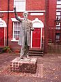
Statue of William Booth, on Notintone Place
-
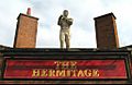
Statue of Bendigo on the former Hermitage pub


See also
 In Spanish: Sneinton para niños
