South Pass (Wyoming) facts for kids
Quick facts for kids South Pass |
|
|---|---|
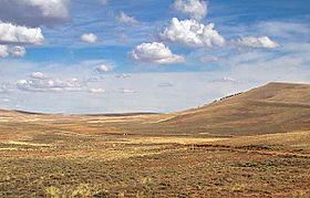
Historic South Pass, seen from the east looking westward towards Pacific Springs
|
|
| Elevation | 7,412 ft (2,259 m) |
| Traversed by | Oregon Trail, California Trail, and Mormon Trail, Wyoming Highway 28 |
| Location | Fremont County, Wyoming United States |
| Range | Wind River Range and Antelope Hills (Radium Springs, Wyoming) |
| Coordinates | 42°22′12″N 108°54′49″W / 42.37000°N 108.91361°W |
| Topo map | USGS Pacific Springs |
|
South Pass
|
|
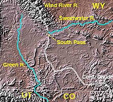
Map of southwestern Wyoming showing location of South Pass at the headwaters of the Sweetwater River
|
|
| Lua error in Module:Location_map at line 420: attempt to index field 'wikibase' (a nil value). | |
| Nearest city | South Pass City, Wyoming |
| NRHP reference No. | 66000754 |
| Significant dates | |
| Added to NRHP | October 15, 1966 |
| Designated NHL | January 20, 1961 |
South Pass is a special route across the Continental Divide in the Rocky Mountains. It is located in southwestern Wyoming. This pass is a wide, high area about 35 miles (56 km) across. It sits between the tall Wind River Range to the north and the Oregon Buttes to the south.
Even though it's about 1.5 miles (2.4 km) high, South Pass is the lowest point on the Continental Divide in the central and southern Rockies. This made it a natural and easy crossing point. In the 1800s, it became the main route for people traveling west. These travelers used the Oregon Trail, California Trail, and Mormon Trail. South Pass was named a U.S. National Historic Landmark in 1961.
Contents
History of South Pass
South Pass was well known to Native Americans for a long time. The first European Americans crossed it in 1812. They were looking for a safer way to return from the West Coast. Finding this easy crossing through the Rockies was a big step in the United States' westward expansion.
Who First Crossed South Pass?
The first recorded crossing by European Americans was on October 22, 1812. Robert Stuart and six friends from the Pacific Fur Company made this journey. They were trying to avoid Crow warriors as they returned to St. Louis, Missouri from Astoria, Oregon. A Shoshone person told Stuart about a shorter path to the south.
The famous Lewis and Clark Expedition (1803-1806) did not find South Pass. They were looking for a water route across the Continental Divide. They followed a northern path up the Missouri River. They crossed the Rockies over difficult passes in the Bitterroot Range.
How Was South Pass Rediscovered?
After Stuart's crossing, the War of 1812 slowed down exploration. South Pass was rediscovered in 1823 by William Henry Ashley's Rocky Mountain Fur Company. Jedediah Smith and his group made the first crossing from east to west in February 1824. Ashley then started the first Rocky Mountain Rendezvous in 1825.
In 1832, Captain Benjamin Bonneville helped create a wagon road across the pass. His group used 20 wagons instead of pack-trains. They supplied fur trappers from Fort Bonneville, which they built near the Green River.
Early Travelers and Settlers
In 1834, Nathaniel Jarvis Wyeth led the first Methodist missionaries across the pass. These included Jason Lee, Daniel Lee, and Cyrus Shepard. They were joined by the naturalist John Kirk Townsend. He wrote about this first use of the Oregon-California Trail.
- In 1835, Thomas Fitzpatrick guided Protestant missionaries Samuel Parker and Dr. Marcus Whitman across the pass.
- In 1836, Fitzpatrick guided the "First White Women to Cross This Pass." These were Narcissa Whitman and Eliza Hart Spalding, along with their husbands.
- By 1838, four more American missionary women had crossed South Pass.
The first family of emigrants to settle in Oregon, the Walkers, crossed the pass in 1840. Joel Pickens Walker and his wife Mary Young Walker traveled with their four children. In 1841, Fitzpatrick led the Bartleson-Bidwell Party across the pass. This was the very first wagon train.
Mapping and Military Expeditions
In 1842, John C. Fremont led a United States Army Corps of Topographical Engineers expedition to map South Pass. He reached the pass on August 8, 1842. Fremont noted how gradual the climb was. He said they had to look closely to find the highest point. In 1843, Fremont figured out the pass's elevation was 7,490 feet (2,283 m) above sea level. He called it about halfway between the Mississippi River and the Pacific Ocean on the common travel route.
Stephen W. Kearny led the first military expedition to South Pass in 1845. By 1848, over 18,000 Americans had crossed the pass. By 1860, more than 300,000 people had used this important route.
Gold and Mining Near South Pass
Gold was found near the pass as early as 1842. However, a big rush of miners didn't happen until 1867. This was after a gold sample was taken to Salt Lake City. The gold rush led to new mining towns like South Pass City and Atlantic City.
The easy-to-find gold in the streams ran out quickly. By 1870, many miners started to leave. In 1884, Emile Granier, a French mining engineer, started a new way of mining using water pressure. This allowed gold mining to continue. Gold mining started again in nearby Rock Creek in the 1930s. From 1962 to 1983, a U.S. Steel iron ore mine operated in Atlantic City. The company's railroad crossed South Pass.
After the Pacific Telegraph Act of 1860, South Pass Station was built in 1861. It was located at the Last Crossing on the Sweetwater River.
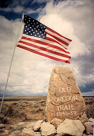
Wyoming Highway 28 now crosses the modern pass. It generally follows the old Oregon Trail route. You can still clearly see the wagon ruts in many places near the highway.
What is the Topography of South Pass?
South Pass is a wide, open saddle of land. It has prairie and sagebrush plants. This makes for a broad and nearly flat route between the Atlantic and Pacific watersheds. The Sweetwater River flows past the east side of the pass. Pacific Creek starts on the west side.
The historic South Pass is the lower of two passes, at an elevation of 7,412 feet (2,259 m). This was the easy crossing point for emigrants. Wyoming Highway 28 crosses the Continental Divide about 2.5 miles (4.0 km) to the northwest. This crossing is also called South Pass and is at 7,550 feet (2,300 m). The Lander Cutoff Route crosses the Continental Divide further northwest. It is about 25 miles (40 km) from the South Passes, at an elevation of 8,030 feet (2,450 m).
See also
 In Spanish: Paso Sur (Wyoming) para niños


