
Southern California Bight facts for kids
Quick facts for kids Southern California Bight |
|
|---|---|

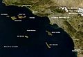
Satellite view of the Southern California Bight in California, including the Channel Islands
|
|
| Location | California, United States Baja California, Mexico |
| Coordinates | 32°43′N 118°21′W / 32.717°N 118.350°W |
| Length | 685 km (426 mi) |
The Southern California Bight is a large curved coastline. It stretches for about 426 miles (685 km). This area runs along the west coast of the United States and Mexico. It goes from Point Conception in California to Punta Colonet in Baja California.
The bight also includes the part of the Pacific Ocean within this curve. This area has several islands. These include the Channel Islands in California. It also has the Coronado Islands and Islas de Todo Santos in Baja California.
This region has a climate like the Mediterranean. This means it has rainy winters and dry summers. The Southern California Bight is home to many plants and animals. You can find fish, birds, and mammals here.
Contents
History of the Southern California Bight
Native American groups lived in this area for thousands of years. They were here long before Europeans arrived. The Chumash people lived in the northern coastal part of the bight. They also lived on the four Northern Channel Islands. The Tongva (or Gabrieleño) lived in the Los Angeles Basin and on the Southern Channel Islands. The Luiseño and Kumeyaay lived in the southern part of the bight.
In 1542, Spanish explorers arrived. Juan Rodríguez Cabrillo and his crew were the first Europeans to land. They landed near what is now San Diego Bay. Cabrillo is thought to be buried on one of the Channel Islands.
The first European settlers came in 1769. They were led by Juan Pérez. The Spanish government wanted to settle in Alta California. This was to stop Russian settlements in the area.
In 2013-2014, many sea stars died. This was the biggest die-off ever seen on the Pacific Coast. A sickness called sea star wasting disease caused this. Sea stars are very important to the ecosystem. Their loss changed the balance of other creatures.
Geography of the Bight

The Southern California Bight has many different land types. It has flat alluvial plains and marine terraces. These are broken up by mountains from the Transverse and Peninsular Ranges. Many islands are located off the coast. The largest is Santa Cruz Island in the Channel Islands.
The northern and central parts of the bight are very urban. This includes the Greater Los Angeles and San Diego-Tijuana areas. The rest of the region is mostly rural. Other big cities along the bight include Santa Barbara, Ventura, Oxnard, Playas de Rosarito, and Ensenada.
Climate in Southern California
The northern part of the bight has a Mediterranean climate. This means it has hot, dry summers and mild, wet winters. The central and southern parts have a semi-arid climate. These areas have hot, dry summers and cool, wet winters.
A marine layer often forms near the coast. This happens in late spring and early summer. It brings cooler air to coastal towns. If the air is very moist, it also brings fog.
There is a 10°C (18°F) difference in average monthly temperature. This is between the cities of Los Angeles and San Diego. Most rain falls in December, January, and February. The average rainfall is about 2 to 3.3 inches (51 to 84 mm) per month.
Marine Life and Ecosystems
The Southern California Bight is a meeting point for different ocean waters. These include waters from the Pacific subarctic and equatorial regions. Because of this, many types of fish live here. Fish from other water masses can be found here too.
The bight is home to 481 kinds of California marine fish. It also has 195 bird species. Seven types of pinnipeds (seals and sea lions) live here.
Tiny Ocean Plants: Phytoplankton
Phytoplankton are very important in the coastal ecosystem. These are tiny, single-celled organisms. They are the main food source for zooplankton (tiny animals). They also help feed the fish population.
Phytoplankton create a strong food chain for all coastal animals. When more phytoplankton grow, there are more fish. This helps local fishing industries.
Fish Species in the Bight

Scientists are studying basking sharks (Cetorhinus maximus). This research program started in 2009 by NOAA.
Here are some common fish found in different ocean zones:
- Surface Zone (Epipelagic):
* Northern anchovy (Engraulis mordax) * Pacific mackerel (Scomber australasicus) * Pacific bonito (Sarda chiliensis) * Yellowtail (Seriola lalandi dorsalis) * Blue shark (Prionace glauca) * Swordfish (Xiphias gladius)
- Nearshore Zone (Neritic):
* Queenfish (Seriphus politus) * White croaker (Genyonemus lineatus) * Pacific butterfish (Peprilus simillimus) * Walleye surfperch (Hyperprosopon anale)
- Rocky Shore Zone (Intertidal):
* Woody sculpin (Clinocottus analis) * Rockpool blenny (Hypsoblennius gilberti) * Spotted kelpfish (Gibbonsia elegans)
Many fish depend on kelp forests for survival. Areas with more kelp have larger fish populations. Fish that live in kelp forests include kelp surfperch (Brachyistius frenatus), kelp bass (Paralabrax clathratus), giant kelpfish (Heterostichus rostratus), and kelp rockfish (Sebastes atrovirens).
A study near San Luis Obispo, California, showed this. When kelp was removed from a reef, fish numbers dropped by 63%. Young fish use kelp beds as safe places to grow. Southern California Edison built a 174-acre (70 ha) kelp reef in 2008.
Birds of the Coast

The Southern California Bight is home to 195 bird species. This includes endangered birds like the light-footed clapper rail (Rallus longirostris levipes).
Some birds nest and hunt near water. This includes bays, harbors, and oceans, especially where kelp grows. Birds like the brown pelican and some cormorants dive headfirst to catch fish. Other birds, such as grebes and loons, migrate from Baja California. They stop in the nearshore waters to fish and feed.
Birds living on rocky shores have special ways to find food. They can grab prey that clings to the rocks. Common rocky seashore birds include black oystercatchers (Haemotopus bachmani), wandering tattlers (Heteroscelus incanus), and Surfbirds (Aphorize virgata).
Other birds, like sandpipers, egrets, and herons, use the tides. They go out to rocks during low tide to find food. Non-seabirds also nest on rocky cliffs. Peregrine falcons and ravens are known to nest on remote sea cliffs. Sandy beaches are home to plovers, terns, marbled godwits (Limosa fedoa), and several types of gulls.
Marine Mammals and Their Journeys
The Southern California Bight has many marine mammals. This is because warm and cool ocean currents meet here. Some mammals live here all the time. Others pass through on their long migration routes. Some only visit to find food.
Laws like the Marine Mammal Protection Act of 1972 and the Endangered Species Act protect these animals. They prevent hunting or harming marine mammals.
Pinnipeds (Seals and Sea Lions)
The most common pinnipeds in the bight are California sea lions. Northern elephant seals have breeding grounds here. They mostly use San Miguel and San Nicolas islands.
Sea otters used to be common. But due to hunting, they mostly live in northern waters now. Otter sightings in the Southern California Bight are rare.
Cetaceans (Whales and Dolphins)
Gray whales travel through the Southern California Bight. They migrate very close to land. They pass southbound from December to February, heading to Baja California. They return northbound from February to May, going towards southern Alaska. Their migrations are among the longest for any mammal, covering over 10,000 miles (16,100 km).
Blue whales also use the bight for their migrations. They leave Baja California by early summer. They are usually in the Southern California Bight in June. The common dolphin is the most common whale or dolphin here. Common dolphins appear more often in warmer water years. They are most common in summer and winter.
Natural Resources of the Bight
The Southern California Bight has oil reserves along its coast and offshore. For the last 100 years, coastal cities like Goleta, Santa Monica, and Huntington Beach have had oil extraction sites. This means there are also pipelines and other structures related to oil.
Other important resources from this region include anchovies, sardines, mackerel, and bass. The rich marine life and easy access to seafood have led to many harbors and marinas. These are found all along the Southern California coast.
Images for kids
-
Satellite view of the Southern California Bight in California, including the Channel Islands
-

Coastal fog covers the city of Ensenada on an April evening. The fog usually clears by midday.
-
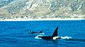
Orcas swimming off Santa Rosa Island
-
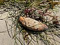
A sweet potato sea cucumber found on a beach in Santa Barbara, California
-
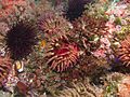
Marine life near Santa Cruz Island


