Sydenham facts for kids
Quick facts for kids Sydenham |
|
|---|---|
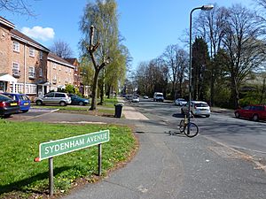 Sydenham Avenue |
|
| Population | 28,378 (SE26 postcode area) |
| OS grid reference | TQ352714 |
| London borough | |
| Ceremonial county | Greater London |
| Region | |
| Country | England |
| Sovereign state | United Kingdom |
| Post town | LONDON |
| Postcode district | SE26 |
| Dialling code | 020 |
| Police | Metropolitan |
| Fire | London |
| Ambulance | London |
| EU Parliament | London |
| UK Parliament |
|
| London Assembly |
|
| Website | http://sydenham.org.uk/ |
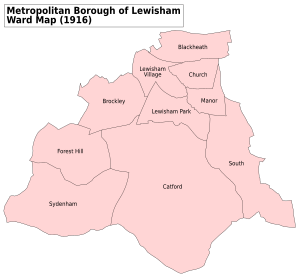
Sydenham is a lively area in south-east London. It's split across three London boroughs: Lewisham, Bromley, and Southwark. Before 1889, Sydenham was part of Kent. It was once a very rich town. The famous Crystal Palace building, which was part of the Great Exhibition, was moved here in 1854. Today, Sydenham is a diverse place with over 28,000 people living here. It borders other areas like Forest Hill and Dulwich.
Contents
- Sydenham's Past: A Journey Through Time
- Exploring Sydenham Today
- Sydenham Hill: High Views and History
- Upper Sydenham: A Mix of Old and New
- Lower Sydenham & Bell Green: Shopping and Green Spaces
- Sydenham's Shopping Streets
- Community Spirit in Sydenham
- Special Protected Areas
- Parks and Green Spaces
- Sydenham Arts: Celebrating Creativity
- Important Buildings and Structures
- Who Lives in Sydenham?
- Getting Around Sydenham
- Sydenham's Location and Landscape
- Fun Facts About Sydenham
Sydenham's Past: A Journey Through Time
Sydenham has a long and interesting history. It started as a small village and grew into the busy area we see today.
How Sydenham Got Started
Sydenham was first called Shippenham. It was just a few small houses hidden among the woods. The people living there would let their animals graze and collect wood from the forests.
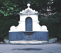
In the 1640s, something exciting happened. Special water springs were found in what is now Wells Park. People believed this water had healing powers. This discovery brought many visitors to the area.
The Arrival of Transport and Industry
Sydenham grew much faster in the 1800s. In 1809, the Croydon Canal was built. It connected the Grand Surrey Canal to Croydon. A large water storage area, called a reservoir, was also built in Sydenham.
However, the canal was not very successful. It closed in 1836. This made it the first canal in Britain to be officially closed by law. The London & Croydon Railway bought the canal. They quickly turned the canal's path into a railway line. This new railway opened in 1839, connecting London Bridge to West Croydon.
After the railway opened, gas companies became interested in Sydenham. The Crystal Palace and District Gas Company built a factory at Bell Green. This factory made gas until 1969. Now, a shopping area stands on most of that site.
The Famous Crystal Palace Era
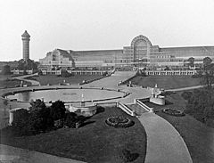
In 1851, the Great Exhibition was held in Hyde Park. It featured an enormous glass building known as the Crystal Palace. In 1854, a company bought this building. They took it apart and rebuilt it in Sydenham Park. This park is now called Crystal Palace Park.
The Crystal Palace in Sydenham became a popular place. It hosted exhibitions, concerts, and sports events. Because of this, Sydenham became a very fashionable area, and many new houses were built. Sadly, the Crystal Palace burned down in 1936.
In 1872, the Children's Hospital in Sydenham opened. It helped many young patients. This hospital closed in 1991, and its services moved to University Hospital Lewisham.
Changes in Sydenham's Railways
In 1884, Upper Sydenham railway station opened. It connected Crystal Palace to London Victoria. However, this station and line were not used much. People preferred other nearby stations like Sydenham Hill (opened 1863) and Crystal Palace (Lower Level). These stations offered more direct routes. After the Crystal Palace burned down in 1936, even fewer people used the Upper Sydenham line. It finally closed in 1954.
Sydenham During World War II
During the Second World War, Sydenham was attacked. The gas works were a target, but they were never badly damaged. The railway line that went through Upper Sydenham station was damaged. Some homes in the area were also destroyed.
Exploring Sydenham Today
Sydenham is made up of different smaller areas, each with its own feel.
Sydenham Hill: High Views and History
Sydenham Hill is one of the highest spots in Greater London. It is 112 metres above sea level. From here, you can see the skyline of the City of London. Sydenham Hill runs alongside Dulwich and Sydenham Woods.
There's an old, unused railway tunnel from the Crystal Palace and South London Junction Railway hidden within these woods. Another railway tunnel, one of Britain's longest at 1,958 metres, runs underneath. This tunnel is part of the Chatham Main Line. Sydenham Hill station serves this area.
Upper Sydenham: A Mix of Old and New
Upper Sydenham is also located on Sydenham Hill. It's a diverse area with people from many backgrounds. The main street of Sydenham used to be the central part of Kirkdale. It was renamed "Kirkdale" in 1936. Today, it has shops like Costcutter and Tesco Express, plus local pubs.
Sydenham School is on Dartmouth Road. Green Flag awarded Sydenham Wells Park is one of the largest parks here. This park is where the famous healing springs were found long ago. Upper Sydenham also has allotments for gardening and the Sydenham Hill estate.
Lower Sydenham & Bell Green: Shopping and Green Spaces
Lower Sydenham & Bell Green is home to Sydenham Community Library. This library was recently reopened by local people after the Lewisham Council closed it.
The Bell Green area has been redeveloped. A new retail park opened in 2013 on the site of an old gas works. This park has big stores like Currys PC World, B&Q, and Next. Sainsbury's has had a large store here since the 1990s. New homes have also been built.
The Bridge Leisure Centre is on Kangley Bridge Road. Mayow Park is near the border with Forest Hill. Along the Hayes railway line, the Lower Sydenham industrial estate has many businesses. It also has the Beckenham and Sydenham Cricket Ground.
Sydenham's Shopping Streets
Sydenham's main shopping area starts around Cobbs Corner on Kirkdale. It then continues onto Sydenham Road, which is often called Sydenham High Street. You'll find many independent shops here, including bookshops, cafes, and a bakery. There are also chain stores like Boots, Lidl, and Superdrug. The Post Office is here, along with several banks like Barclays and Lloyds Bank.
Community Spirit in Sydenham
Sydenham has a very active community. Many groups work to improve the local area. Sydenham Town is a local website where residents can share their ideas. The Sydenham Society, started in 1972, represents the community. It organises events and works with local authorities.
Sydenham Garden is a charity that helps improve the health of people in Bromley and Lewisham. It was started in 2002 and has won awards. Sydenham and Forest Hill won a national competition called Portas Pilot. This gave them money to improve their high streets.
Every summer since 2009, the Sydenham Arts Festival takes place. It offers workshops, music, and family activities.
Special Protected Areas
Sydenham has seven Conservation Areas. These are special places protected for their historical or architectural importance. They include Cobbs Corner, Dulwich Village (Crescent Wood Road), Halifax Street, Sydenham Hill/Kirkdale, Sydenham Park, and Sydenham Thorpes. Sydenham has the most conservation areas in the London Borough of Lewisham.
Parks and Green Spaces
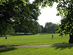
Sydenham has many parks and open spaces. Mayow Park, Lewisham's oldest park, and Sydenham Wells Park have both won Green Flag Awards. Other green areas include Alexandra Recreation Ground and Kirkdale Green. Riverview Walk is a nature area along the River Ravensbourne. Nearby, you can also find Crystal Palace Park, Dulwich Woods, and Sydenham Hill Woods.
Sydenham Arts: Celebrating Creativity
Sydenham Arts is a local charity that supports the arts. It organises free and ticketed cultural events throughout the year. In 2016, former Poet Laureate Sir Andrew Motion praised the Sydenham Arts Festival. He said it was "packed with high-quality speakers" and supported local talent.
Important Buildings and Structures
Sydenham has many interesting buildings:
- St Bartholomew's church (1827–1832) is at the end of Lawrie Park Avenue. It was painted by Camille Pissarro in 1871.
- Six Pillars (1934–35) on Crescent Wood Road is a unique house designed by Berthold Lubetkin. It has six pillars at street level.
- Cobbs Corner is named after a large department store run by Walter Cobb. You can see the date on its impressive dome.
- 180 and 182 Kirkdale were built in the 1850s in a Gothic style.
- 168–178 Kirkdale are three pairs of Italian-style houses from around 1862.
- The Memorial to Queen Victoria (1897) is a grand monument celebrating her Diamond Jubilee.
- Jews Walk is believed to be named after a wealthy Jewish resident. Karl Marx's daughter, Eleanor, lived on Jews Walk. A blue plaque marks her former home.
- Halifax Street is a well-preserved street with houses from the 1840s.
- The Kirkdale Building, once the Sydenham Public Lecture Hall, was built in 1861.
Who Lives in Sydenham?
In 2011, the SE26 postcode area had a population of 28,378 people. There were slightly more females (14,664) than males (13,714).
Famous People from Sydenham
Many well-known people have lived in or been connected to Sydenham:
- John Logie Baird — the inventor of the first colour television system.
- George Baxter — invented colour printing.
- Thomas Campbell — a famous poet.
- Connie Fisher — a singer and actress who won a BBC TV show.
- Bud Flanagan — a popular music hall entertainer.
- W. G. Grace — considered England's greatest cricketer.
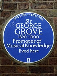
- George Grove — known for his musical dictionary.
- Kazuo Ishiguro — a novelist who won the Booker Prize. He wrote The Remains of the Day in Sydenham.
- Eleanor Marx — daughter of the famous thinker Karl Marx.
- Sandy Powell — a costume designer who has won three Academy Awards.
- Ernest Shackleton — the famous Antarctic explorer.
- Dame Cicely Saunders — started the modern hospice movement.
- Jason Statham — a well-known film actor.
- Bill Wyman — a member of the legendary band The Rolling Stones.
- Lionel Logue — an Australian speech therapist who helped King George VI.
- Richard Jefferies — a naturalist and author.
- David Bowie — the iconic musician lived in Sydenham for five years.
- Margaret Lockwood — star of Alfred Hitchcock's The Lady Vanishes.
Getting Around Sydenham
Sydenham has good public transport links, including trains and buses. It is in Travelcard Zones 3 and 4.
Train Stations in Sydenham
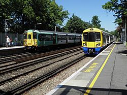
- Sydenham station is the busiest. You can catch London Overground and Southern trains here. They go to places like London Bridge, London Victoria, and Highbury & Islington.
- Sydenham Hill and Penge East stations offer Southeastern services. These trains go to London Victoria and Bromley South.
- Lower Sydenham station also has Southeastern trains. They connect to London Charing Cross, London Bridge, and Hayes.
Bus Services
Many bus routes serve Sydenham. Buses like the 75, 122, 176, and 194 connect Sydenham to Central London, Lewisham, Croydon, Bromley, and other nearby areas.
Roads and Driving
The South Circular Road is close by in Forest Hill. Improvements are being made to the busy Sydenham Road (A212) to make it easier to use.
Sydenham's Location and Landscape
Sydenham is about 7 miles (11 km) south-east of Charing Cross in central London. It's also close to major shopping areas: 3 miles (5 km) south of Lewisham, and about 3 miles (5 km) from Bromley and Croydon.
Hills and Woods
Upper Sydenham and Sydenham Hill are on the Norwood Ridge. Sydenham Hill is one of London's highest points at 367 feet (112 m). Sydenham Hill Wood is a nature reserve. This area was once part of the Great North Wood, a huge forest that covered much of Sydenham. In the 1800s, Sydenham Wells was a popular health resort here.
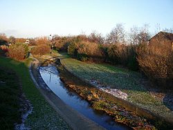
The western parts of Sydenham, like Lawrie Park, are greener and more suburban. Lower Sydenham is to the east. The River Pool, a small river that flows into the River Ravensbourne, runs along the east of Lower Sydenham.
Local Climate
The nearest official weather station is in Greenwich Park.
| Climate data for London (Greenwich) | |||||||||||||
|---|---|---|---|---|---|---|---|---|---|---|---|---|---|
| Month | Jan | Feb | Mar | Apr | May | Jun | Jul | Aug | Sep | Oct | Nov | Dec | Year |
| Record high °C (°F) | 14.0 (57.2) |
19.7 (67.5) |
21.0 (69.8) |
26.9 (80.4) |
31.0 (87.8) |
35.0 (95.0) |
35.5 (95.9) |
37.5 (99.5) |
30.0 (86.0) |
28.8 (83.8) |
19.9 (67.8) |
15.0 (59.0) |
37.5 (99.5) |
| Mean daily maximum °C (°F) | 8.3 (46.9) |
8.5 (47.3) |
11.4 (52.5) |
14.2 (57.6) |
17.7 (63.9) |
20.7 (69.3) |
23.2 (73.8) |
22.9 (73.2) |
20.1 (68.2) |
15.6 (60.1) |
11.4 (52.5) |
8.6 (47.5) |
15.2 (59.4) |
| Mean daily minimum °C (°F) | 2.6 (36.7) |
2.4 (36.3) |
4.1 (39.4) |
5.4 (41.7) |
8.4 (47.1) |
11.5 (52.7) |
13.9 (57.0) |
13.7 (56.7) |
11.2 (52.2) |
8.3 (46.9) |
5.1 (41.2) |
2.8 (37.0) |
7.5 (45.5) |
| Record low °C (°F) | −10.0 (14.0) |
−9.0 (15.8) |
−8.0 (17.6) |
−2.0 (28.4) |
−1.0 (30.2) |
5.0 (41.0) |
7.0 (44.6) |
6.0 (42.8) |
3.0 (37.4) |
−4.0 (24.8) |
−5.0 (23.0) |
−7.0 (19.4) |
−10.0 (14.0) |
| Average precipitation mm (inches) | 51.6 (2.03) |
38.2 (1.50) |
40.5 (1.59) |
45.0 (1.77) |
46.5 (1.83) |
47.3 (1.86) |
41.1 (1.62) |
51.6 (2.03) |
50.4 (1.98) |
68.8 (2.71) |
58.0 (2.28) |
53.0 (2.09) |
591.8 (23.30) |
| Average rainy days (≥ 1.0 mm) | 10.8 | 8.5 | 9.6 | 9.4 | 9.0 | 8.3 | 8.0 | 7.6 | 8.5 | 10.7 | 10.1 | 9.9 | 110.4 |
| Average snowy days | 4 | 4 | 3 | 1 | 0 | 0 | 0 | 0 | 0 | 0 | 1 | 3 | 16 |
| Average relative humidity (%) | 81.0 | 76.0 | 69.0 | 64.0 | 62.0 | 60.0 | 60.0 | 62.0 | 67.0 | 73.0 | 78.0 | 82.0 | 69.5 |
| Mean monthly sunshine hours | 49.9 | 71.4 | 107.1 | 159.8 | 181.2 | 181.0 | 192.1 | 195.1 | 138.9 | 108.1 | 58.5 | 37.4 | 1,480.5 |
| Source 1: Record highs and lows from BBC Weather, except August and February maximum from Met Office | |||||||||||||
| Source 2: All other data from Met Office, except for humidity and snow data which are from NOAA | |||||||||||||
| Climate data for London (Heathrow airport 1981−2010) | |||||||||||||
|---|---|---|---|---|---|---|---|---|---|---|---|---|---|
| Month | Jan | Feb | Mar | Apr | May | Jun | Jul | Aug | Sep | Oct | Nov | Dec | Year |
| Mean daily maximum °C (°F) | 8.1 (46.6) |
8.4 (47.1) |
11.3 (52.3) |
14.2 (57.6) |
17.9 (64.2) |
21.0 (69.8) |
23.5 (74.3) |
23.2 (73.8) |
19.9 (67.8) |
15.5 (59.9) |
11.1 (52.0) |
8.3 (46.9) |
15.2 (59.4) |
| Mean daily minimum °C (°F) | 2.3 (36.1) |
2.1 (35.8) |
3.9 (39.0) |
5.5 (41.9) |
8.7 (47.7) |
11.7 (53.1) |
13.9 (57.0) |
13.7 (56.7) |
11.4 (52.5) |
8.4 (47.1) |
4.9 (40.8) |
2.7 (36.9) |
7.4 (45.4) |
| Average precipitation mm (inches) | 55.2 (2.17) |
40.9 (1.61) |
41.6 (1.64) |
43.7 (1.72) |
49.4 (1.94) |
45.1 (1.78) |
44.5 (1.75) |
49.5 (1.95) |
49.1 (1.93) |
68.5 (2.70) |
59.0 (2.32) |
55.2 (2.17) |
601.7 (23.68) |
| Average rainy days (≥ 1.0 mm) | 11.1 | 8.5 | 9.3 | 9.1 | 8.8 | 8.2 | 7.7 | 7.5 | 8.1 | 10.8 | 10.3 | 10.2 | 109.6 |
| Mean monthly sunshine hours | 61.5 | 77.9 | 114.6 | 168.7 | 198.5 | 204.3 | 212.0 | 204.7 | 149.3 | 116.5 | 72.6 | 52.0 | 1,632.6 |
| Source: Met Office | |||||||||||||
Nearby Areas
 |
Dulwich | Forest Hill, Perry Vale | Catford, Lewisham |  |
| Crystal Palace | Bellingham, Southend Village | |||
| Upper Norwood, Anerley | Penge, Croydon | Beckenham, Bromley |
Fun Facts About Sydenham
- In 2005, there were reports of a large, black, panther-like animal in Sydenham. It was named Arak and was said to be 6 feet long and 3 feet tall.
- A man named John Hussey from Sydenham lived to be 116 years old! He reportedly drank balm-tea with honey for breakfast and ate pudding for dinner for over 50 years.
 | Claudette Colvin |
 | Myrlie Evers-Williams |
 | Alberta Odell Jones |


