Vernon County, Missouri facts for kids
Quick facts for kids
Vernon County
|
|
|---|---|

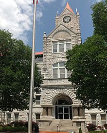
Vernon County Courthouse
|
|

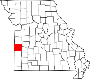
Location within the U.S. state of Missouri
|
|
 Missouri's location within the U.S. |
|
| Country | |
| State | |
| Founded | February 27, 1855 |
| Named for | Colonel Miles Vernon, state senator, and veteran of the Battle of New Orleans |
| Seat | Nevada |
| Largest city | Nevada |
| Area | |
| • Total | 837 sq mi (2,170 km2) |
| • Land | 826 sq mi (2,140 km2) |
| • Water | 10 sq mi (30 km2) 1.2% |
| Population
(2020)
|
|
| • Total | 19,707 |
| • Density | 23.545/sq mi (9.091/km2) |
| Time zone | UTC−6 (Central) |
| • Summer (DST) | UTC−5 (CDT) |
| Congressional district | 4th |
Vernon County is a county located in the western part of Missouri. It sits right on the border with Kansas. In 2020, about 19,707 people lived here.
The main city and county seat is Nevada. Vernon County was officially created on February 27, 1855. It was named after Colonel Miles Vernon, who was a state senator and a hero from the Battle of New Orleans. Long ago, this land was part of the large territory belonging to the Osage Nation, a group of Native Americans.
Contents
History of Vernon County
This county was mostly developed for farming by early settlers. Even today, it remains a mostly rural area with lots of farms.
The Civil War's Impact
Vernon County faced a lot of hardship during the American Civil War. During this time, small groups of fighters, known as guerrillas, attacked Union soldiers. They also carried out personal fights against others in the county.
To stop these attacks, on May 23, 1863, Union Army soldiers burned down Nevada, the county seat. The courthouse was also destroyed. The beautiful courthouse you see today was finished much later, in 1907.
General Thomas Ewing Jr. issued a special order called General Order No. 11 (1863). This order made everyone leave four Missouri counties, including Vernon County. The goal was to stop people from helping the Confederate guerrillas. Most residents could not return home until the Civil War ended in May 1865.
Geography and Location
Vernon County covers a total area of about 837 square miles. Most of this is land, about 826 square miles. The remaining 10 square miles (1.2%) is water.
Neighboring Counties
Vernon County shares its borders with several other counties:
- Bates County (to the north)
- St. Clair County (to the northeast)
- Cedar County (to the east)
- Barton County (to the south)
- Crawford County, Kansas (to the southwest)
- Bourbon County, Kansas (to the west)
- Linn County, Kansas (to the northwest)
Main Roads and Travel
Several important highways pass through Vernon County, making it easy to travel:
 Interstate 49
 U.S. Route 54
 U.S. Route 71
 Route 43
For public transportation, Jefferson Lines provides bus services.
Population and People
The number of people living in Vernon County has changed over the years. Here's how the population has grown and shrunk:
| Historical population | |||
|---|---|---|---|
| Census | Pop. | %± | |
| 1860 | 4,850 | — | |
| 1870 | 11,247 | 131.9% | |
| 1880 | 19,369 | 72.2% | |
| 1890 | 31,505 | 62.7% | |
| 1900 | 31,619 | 0.4% | |
| 1910 | 28,827 | −8.8% | |
| 1920 | 26,069 | −9.6% | |
| 1930 | 25,031 | −4.0% | |
| 1940 | 25,586 | 2.2% | |
| 1950 | 22,685 | −11.3% | |
| 1960 | 20,540 | −9.5% | |
| 1970 | 19,065 | −7.2% | |
| 1980 | 19,806 | 3.9% | |
| 1990 | 19,041 | −3.9% | |
| 2000 | 20,454 | 7.4% | |
| 2010 | 21,159 | 3.4% | |
| 2020 | 19,707 | −6.9% | |
| U.S. Decennial Census 1790-1960 1900-1990 1990-2000 2010 |
|||
Who Lives in Vernon County?
In 2020, the people living in Vernon County included:
| Race | Num. | Perc. |
|---|---|---|
| White (not Hispanic) | 17,966 | 91.2% |
| Black or African American (not Hispanic) | 110 | 0.56% |
| Native American (not Hispanic) | 131 | 0.66% |
| Asian (not Hispanic) | 103 | 0.52% |
| Pacific Islander (not Hispanic) | 18 | 0.1% |
| Other/Mixed (not Hispanic) | 953 | 4.83% |
| Hispanic or Latino | 426 | 2.16% |
Education in Vernon County
Vernon County has several schools and a college.
Public Schools
There are four public school districts serving the area:
- Bronaugh R-VII School District in Bronaugh
- Bronaugh Elementary School (grades PK-6)
- Bronaugh High School (grades 7-12)
- Nevada R-V School District in Nevada
- Bryan Elementary School (grades PK-1)
- Benton Elementary School (grade 2)
- Truman Elementary School (grades 3-5)
- Nevada Middle School (grades 6-8)
- Nevada High School (grades 9-12)
- Northeast Vernon County R-I School District in Walker
- Northeast Vernon County Elementary School (grades PK-6)
- Northeast Vernon County High School (grades 7-12)
- Sheldon R-VIII School District in Sheldon
- Sheldon Elementary School (grades PK-6)
- Sheldon High School (grades 7-12)
Private Schools
- Nevada Seventh-day Adventist Christian School in Nevada (grades 2-7) is a Seventh-day Adventist school.
- St. Mary Elementary School in Nevada (Early Childhood) is a Roman Catholic school.
Colleges and Universities
- Cottey College in Nevada is a private, four-year college just for women.
Public Libraries
- The Nevada Public Library serves the community.
Communities in Vernon County
Vernon County is made up of several towns, villages, and smaller communities.
Cities
- Bronaugh
- Nevada (This is the county seat!)
- Schell City
- Sheldon
Villages
Unincorporated Communities
These are smaller places that don't have their own local government.
Townships
Townships are smaller divisions of the county, often used for local administration.
- Bacon Township
- Badger Township
- Blue Mound Township
- Center Township
- Clear Creek Township
- Coal Township
- Deerfield Township
- Dover Township
- Drywood Township
- Harrison Township
- Henry Township
- Lake Township
- Metz Township
- Montevallo Township
- Moundville Township
- Osage Township
- Richland Township
- Virgil Township
- Walker Township
- Washington Township
See also
 In Spanish: Condado de Vernon (Misuri) para niños
 | Frances Mary Albrier |
 | Whitney Young |
 | Muhammad Ali |


