
York, Maine facts for kids
Quick facts for kids
York, Maine
|
||
|---|---|---|
|
||

York, Maine
Location in Maine
|
||
| Country | United States | |
| State | Maine | |
| County | York | |
| Settled | 1624 | |
| Incorporated | 1652 | |
| Area | ||
| • Total | 131.78 sq mi (341.3 km2) | |
| • Land | 54.67 sq mi (141.6 km2) | |
| • Water | 77.11 sq mi (199.7 km2) | |
| Elevation | 190 ft (60 m) | |
| Population
(2020)
|
||
| • Total | 13,723 | |
| • Density | 104.136/sq mi (40.2070/km2) | |
| Time zone | UTC-5 (Eastern (EST)) | |
| • Summer (DST) | UTC-4 (EDT) | |
| ZIP code |
03909
|
|
| Area code(s) | 207 | |
| FIPS code | 23-87985 | |
| GNIS feature ID | 0582832 | |

York is a town in Maine, a state in the United States. It's located near the southern tip of Maine. In 2020, about 13,723 people lived there.
York is right by the Atlantic Ocean on the Gulf of Maine. It's a popular place for summer vacations. You can find three golf courses, four sandy beaches, and Mount Agamenticus in York. The town has different areas, or villages, like Bald Head, York Village, York Harbor, York Beach, and Cape Neddick. York is also part of the larger Portland area.
Contents
History of York, Maine

Europeans first settled here in 1624. They called the area Agamenticus. This was an Abenaki word for the York River. It was also the name of a hill you could see from the ocean.
In 1638, the settlers changed the name to Bristol. This was after Bristol, England, where many of them came from. Sir Ferdinando Gorges, who owned the land, wanted to build a big city. He named the capital of his area Gorgeana.
On March 1, 1642, King Charles I made Gorgeana the first official city in America.
After Gorges passed away, the Massachusetts Bay Colony took control. In 1652, York, Massachusetts, became a town. It was named after York, England. This made it the second oldest town in Maine, after Kittery.
Control of the area was often fought over by New England and New France. This led to Native American attacks on English settlements. These attacks happened during the French and Indian Wars.

The first church in York was started in 1672. Its leader was Rev. Shubael Dummer.
During King William's War, York was attacked in 1692. This event is known as the Candlemas Massacre. During the attack by the Abenakis, Dummer was shot at his home. About 50 other people were killed. Nearly 100 were taken captive. This included Dummer's wife, Lydia, and their son.
The last local Native American attack happened in 1723. This was in the Cape Neddick area during Dummer's War. The fighting stopped after the French were defeated in 1745. All conflicts ended with the 1763 Treaty of Paris.
York as a Trading Center
York grew as a trading center. It was the capital of the area and had the main jail. Many docks and warehouses were used for trade with the West Indies. Farmers sent their crops and lumber to trade. They received things like sugar and molasses in return.
A famous merchant, John Hancock, had a business here. His old building is now a museum. After the Revolutionary War, trade became difficult. This was because of a law called the Embargo Act of 1807. York lost its status as capital. It didn't become busy again until after the Civil War. Then, its ocean air and old-fashioned charm attracted many tourists. Old homes like the John Sedgley Homestead were popular.
York Today
York became a popular summer vacation spot. It's like Bar Harbor and Newport, Rhode Island. Many beautiful old houses from the Gilded Age can still be seen. These are often in the Shingle style. A group of historic buildings in York Village are now museums. They are looked after by the Old York Historical Society.
Exploring the Villages of York

York is made up of several unique villages:
- York Village – This area has historic buildings and nice shops.
- York Harbor – Here you'll find inns, old homes, and large estates.
- York Beach – This village has fun places like a zoo, arcades, and souvenir shops.
- Cape Neddick – This area is mostly homes. It's famous for its lighthouse.
During the summer, visitors enjoy Short Sands Beach in York Beach. Long Sands Beach is also popular. It's the longest beach in town, stretching over a mile between York Beach and York Harbor. Many hotels and places to stay are in the York Beach area. Most of them close after the summer season.
You can see the Cape Neddick Light (also called Nubble Light) from many places in York. This lighthouse is on Nubble Rock. It has been featured in art and on souvenirs from the Maine coast. A picture of Cape Neddick Light was even sent into space on the Voyager 1 spacecraft! On clear days, you can also see the Boon Island Light. This lighthouse is about 133 feet (41 m) tall. It's located about 6.2 miles (10 km) off York on Boon Island.
Geography and Nature
York covers about 131.78 square miles (341.31 km2). About 54.67 square miles (141.60 km2) is land, and 77.11 square miles (199.71 km2) is water. The York River flows through the town.
The highest point in York is Mount Agamenticus. It is about 692 feet (211 m) above sea level. There's a road to the top. You can find miles of trails for hiking, biking, and horse-riding there. The lowest point is sea level, along the Atlantic Ocean coastline.
York is about 44 miles (71 km) south of Portland. It's about 98 miles (158 km) south of Augusta. It is also about 65 miles (105 km) north of Boston.
Education in York

The York School Department uses the largest part of the town's budget (69%). York has four schools for about 2,000 students.
- Village Elementary School teaches students in kindergarten and first grade.
- Coastal Ridge Elementary School is for grades 2-4.
- York Middle School serves students in grades 5-8.
- York High School is for students in grades 9-12.
Adult education classes are also available for people living in York.
Population of York
| Historical population | |||
|---|---|---|---|
| Census | Pop. | %± | |
| 1790 | 2,900 | — | |
| 1800 | 2,776 | −4.3% | |
| 1810 | 3,046 | 9.7% | |
| 1820 | 3,224 | 5.8% | |
| 1830 | 3,485 | 8.1% | |
| 1840 | 3,111 | −10.7% | |
| 1850 | 2,980 | −4.2% | |
| 1860 | 2,825 | −5.2% | |
| 1870 | 2,654 | −6.1% | |
| 1880 | 2,463 | −7.2% | |
| 1890 | 2,444 | −0.8% | |
| 1900 | 2,668 | 9.2% | |
| 1910 | 2,802 | 5.0% | |
| 1920 | 2,727 | −2.7% | |
| 1930 | 2,532 | −7.2% | |
| 1940 | 3,283 | 29.7% | |
| 1950 | 3,256 | −0.8% | |
| 1960 | 4,663 | 43.2% | |
| 1970 | 5,690 | 22.0% | |
| 1980 | 8,465 | 48.8% | |
| 1990 | 9,818 | 16.0% | |
| 2000 | 12,854 | 30.9% | |
| 2010 | 12,529 | −2.5% | |
| 2020 | 13,723 | 9.5% | |
| sources: | |||

In 2010, there were 12,529 people living in York. There were 5,440 households, and 3,601 families. The average age in York was 49.3 years. About 20.2% of the people were under 18 years old.
Places to Visit in York

Here are some interesting places to see in York:
- Cape Neddick Lighthouse (Nubble Light)
- John Sedgley Homestead
- The Goldenrod
- Short Sands Beach
- Mount Agamenticus
York's Civil War Monument
A monument to a Civil War soldier stands in York Village. It was put up in 1906. Some people think the soldier's uniform looks a bit different from a typical Union soldier's. This might be because the sculptor, Frederick Barnicoat, was English. Or perhaps the designer, John Staples, used a uniform style from a different time, like the Spanish–American War. It's also possible that the 20th Maine Volunteer Infantry Regiment wore a similar uniform.
Famous People from York
Many notable people have connections to York:
- Spencer Albee, musician
- Emerson Baker, historian and author
- Christopher Cassidy, NASA astronaut
- Mandy Cronin, ice hockey executive
- Shubael Dummer, early colonial reverend
- Richard Foerster, poet
- Tim Janis, musician
- Barbara Marois, Olympic field hockey player
- Rufus McIntire, US congressman
- Jeremiah Moulton, colonial officer and judge
- David N. Ott, state representative and lawyer
- Alvah T. Ramsdell, architect
- Neil Rolde, state legislator and Maine historian
- Duncan Robinson, basketball player for the Miami Heat
- Walter Runte, state legislator
- May Sarton, writer
- George Thatcher, state judge and US congressman
- Mark Twain, writer (he spent summers here)
- Windol Weaver, state legislator
Images for kids
-
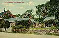
Taylor Cottage in 1913
-
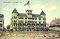
The Wahnita in 1913
-
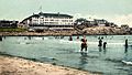
York Beach in 1906
-
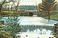
Chase's Pond in 1910
-
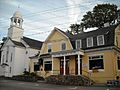
Research Center at Old York
-
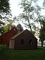
1834 Remick Barn (behind) and Old Schoolhouse (in front)
-
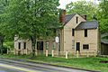
Emerson Wilcox House, 1742, Georgian style, served as a store, a post office and a tavern over time.
-
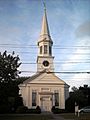
First Parish Church
-
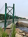
The Wiggly Bridge in York, Maine is the smallest pedestrian suspension bridge in the United States.


See also
 In Spanish: York (Maine) para niños
