Cape York Peninsula facts for kids
- This article is about the peninsula in the Australian state of Queensland; not the Yorke Peninsula in South Australia, or Cape York (Greenland).
Quick facts for kids Cape York Peninsula |
|
|---|---|
 |
|
| Location | Queensland, Australia |
| Area | 288,804 km2 (111,508 sq mi) |
| River | Jardine River |
| Bodies of water | Coral Sea, Torres Strait, Gulf of Carpentaria |
Cape York Peninsula is a huge, wild area in Far North Queensland, Australia. It's known as the largest untouched wilderness in northern Australia. The land is mostly flat. About half of it is used for raising cattle.
This special place has many different natural areas. You can find savannahs with eucalyptus trees, tropical rainforests, and other unique habitats. These areas are very important for the environment worldwide. However, some native animals are in danger from new plants and animals brought in by people.
In 1606, a Dutch sailor named Willem Janszoon was the first known European to reach Australia. He landed on Cape York Peninsula. For a long time after that, not many people explored this area. Much of Cape York remains a wild frontier, mostly untouched by human presence.
Contents
Exploring Cape York
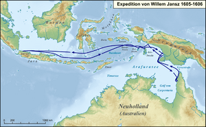
In February 1606, Dutch explorer Willem Janszoon landed near where Weipa is today. This was on the western side of Cape York. It was the first time a European was recorded landing in Australia. It was also the first known meeting between Europeans and Aboriginal Australian people.
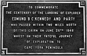
Edmund Kennedy was the first European to try exploring Cape York Peninsula by land. He had been part of another expedition before. His goal was to find a path to the very tip of the peninsula. Businessmen in Sydney wanted to build a port there for trade.
Kennedy's expedition started in May 1848 from Rockingham Bay. This journey became one of Australia's biggest exploration disasters. Out of thirteen men who started, only three survived. Many died from illness or hunger. Some were attacked by local Aboriginal people. Kennedy himself died from spear wounds in December 1848, very close to his goal. The only person to finish the journey was Jackey Jackey, an Aboriginal Australian guide. He then led a rescue team to find the other two survivors.
The peninsula was finally reached by land in 1864. Two brothers, Francis (Frank) and Alexander William Jardine, led a group of eight. They drove cattle from Rockhampton to a new settlement called Somerset on Cape York. Their father was the commander there. On their way, they lost many horses and supplies. They also had conflicts with Aboriginal Australians. They finally arrived in March 1865.
Land and Rocks
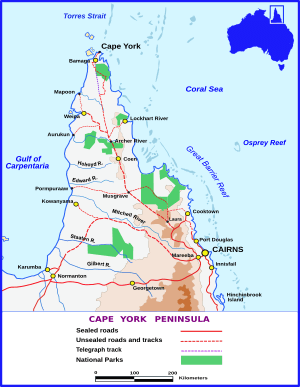
Cape York Peninsula has water on three sides. The west coast touches the Gulf of Carpentaria. The east coast borders the Coral Sea. To the north is the Torres Strait. There isn't a clear southern border, but the official line is around 16°S latitude.
At its widest, the peninsula is about 430 km (270 mi) across. It stretches from the Bloomfield River in the southeast to the west coast near Kowanyama. From its southern border to the tip of Cape York, it's about 660 km (410 mi) long. Some large islands in the Torres Strait include Prince of Wales Island, Horn Island, Moa, and Badu Island.
At the very top of the peninsula is Cape York. This is the northernmost point of mainland Australia. Lieutenant James Cook named it on August 21, 1770. He named it after Prince Edward, Duke of York and Albany, who was a brother of King George III of the United Kingdom.
The landscapes here are very old and stable. They haven't been changed much by earthquakes. The peninsula is a very flat plain. It has winding rivers and large floodplains. There are some low hills, reaching about 800 m (2,600 ft) high, in the McIlwraith Range.
The main part of Cape York Peninsula is the peninsula ridge. This is part of Australia's Great Dividing Range. This mountain range is made of very old rocks, about 1.5 billion years old. Over time, these rocks have worn down a lot.
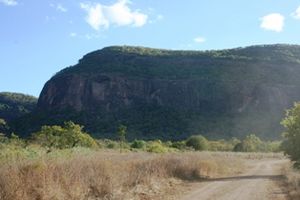
There are some amazing landforms here. You can see huge areas of sand dunes on the eastern coast. There are also giant piles of black granite boulders at Black Mountain National Park. Another interesting feature is the limestone karst areas in the south.
Soil
The soils on Cape York Peninsula are not very fertile. This is even true compared to other parts of Australia. They are very old and weathered. This poor soil is why not many people live here. It's hard to grow crops because the soil doesn't respond well to fertilisers.
Weather
The climate on Cape York Peninsula is tropical and monsoonal. This means it has a very wet season and a dry season. The heavy monsoon season runs from November to April. During this time, it's very hard to travel. The dry season is from May to October.
Temperatures are usually warm to hot. Higher areas are a bit cooler. Average yearly temperatures range from 18 °C (64 °F) in high places to 27 °C (81 °F) in the lowlands. Temperatures rarely go above 40 °C (104 °F) or below 5 °C (41 °F).
There's a lot of rain each year. It can be over 2,000 millimetres (79 in) in some areas, and about 700 millimetres (28 in) at the southern border. Almost all this rain falls between November and April.
| Climate data for Cape York | |||||||||||||
|---|---|---|---|---|---|---|---|---|---|---|---|---|---|
| Month | Jan | Feb | Mar | Apr | May | Jun | Jul | Aug | Sep | Oct | Nov | Dec | Year |
| Mean daily maximum °C (°F) | 29.8 (85.6) |
29.6 (85.3) |
29.6 (85.3) |
29.5 (85.1) |
28.8 (83.8) |
28.1 (82.6) |
27.6 (81.7) |
27.8 (82.0) |
28.5 (83.3) |
29.9 (85.8) |
30.9 (87.6) |
30.8 (87.4) |
29.2 (84.6) |
| Mean daily minimum °C (°F) | 24.0 (75.2) |
23.9 (75.0) |
23.8 (74.8) |
23.7 (74.7) |
23.0 (73.4) |
22.3 (72.1) |
21.5 (70.7) |
21.6 (70.9) |
22.2 (72.0) |
22.9 (73.2) |
23.8 (74.8) |
24.2 (75.6) |
23.1 (73.6) |
| Average rainfall mm (inches) | 370.6 (14.59) |
352.1 (13.86) |
370.9 (14.60) |
205.5 (8.09) |
49.1 (1.93) |
21.1 (0.83) |
19.7 (0.78) |
9.5 (0.37) |
11.4 (0.45) |
34.9 (1.37) |
156.7 (6.17) |
194.6 (7.66) |
1,794.7 (70.66) |
Rivers
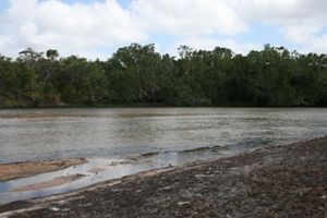
The peninsula ridge acts like a natural wall. It separates the rivers flowing into the Gulf of Carpentaria from those flowing into the Coral Sea. To the west, large, winding rivers like the Mitchell and Jardine flow into the Gulf. In the dry season, these rivers become just a few waterholes. But in the wet season, heavy rains make them huge. They spread across wide floodplains, bringing life to many water animals.
On the eastern side, shorter, faster rivers flow towards the Coral Sea. These include the Olive and Endeavour Rivers. They provide fresh water and nutrients to the Great Barrier Reef. These wild rivers are often lined with thick rainforests or mangroves.
The rivers of Cape York Peninsula are very special because they are mostly untouched. Their water flows and the plants around them are still natural. This makes Cape York Peninsula one of the few places where tropical water cycles are still working perfectly. The peninsula provides about a quarter of Australia's surface water runoff. Even though it's only about 2.7% of Australia's land, it produces more runoff than all of Australia south of the Tropic of Capricorn. These rivers also help refill Australia's huge Great Artesian Basin.
How the Land Formed
The peninsula is the northern part of the Great Dividing Range. This range formed about 300 million years ago. That's when Australia collided with parts of what are now South America and New Zealand. Since then, the mountains have worn down a lot.
Around 40 million years ago, the Indo-Australian tectonic plate started to break away from the ancient supercontinent Gondwana. As it moved north and crashed into the Pacific Plate, the high mountains of New Guinea formed about 5 million years ago. But the old rocks of Cape York Peninsula stayed mostly calm during this time.
During the Pleistocene epoch, Australia and New Guinea were sometimes connected by land and sometimes separated by water. When sea levels were low due to ice ages, Cape York Peninsula was a land bridge. This bridge connected Australia to New Guinea. This connection lasted until the shallow Torres Strait was flooded about 8,000 years ago.
People and Culture
The first known meeting between Europeans and Aboriginal Australians happened on the west coast in 1606. But Europeans didn't settle here until the 1800s. Fishing villages, cattle stations, and mining towns were then built. European settlement led to Aboriginal communities being moved. Also, Torres Strait Islanders started moving to the mainland.
Today, only about 18,000 people live on the peninsula. A large number, about 60%, are Indigenous Australians and Torres Strait Islanders.
Cooktown is the main town for business and administration. It's in the far southeastern part of the peninsula. The biggest town is Weipa, a mining town on the Gulf of Carpentaria. The rest of the area is very empty. About half the people live in small settlements and cattle ranches. Along the main road, there are small service centers like Lakeland, Laura, and Coen.
About 30 km (19 mi) north of Cape York's tip, there's a service center on Thursday Island. Aboriginal communities include Hopevale, Pormpuraaw, Kowanyama, Aurukun, Lockhart River, Napranum, Mapoon, Injinoo, New Mapoon, and Umagico. Torres Strait Islander communities on the mainland are Bamaga and Seisia.
A fully paved road connects Cairns and the Atherton Tableland to Lakeland and Cooktown. The road north of Lakeland Downs to the tip of the peninsula can sometimes be closed. This happens after heavy rains in the wet season, usually from December to May.
The peninsula is a popular place for tourists in the dry season. People enjoy camping, hiking, bird watching, and fishing. Many people take the adventurous drive to the tip of Cape York. This is the northernmost point of mainland Australia.
Around the town of Laura, you can find some of the world's oldest and largest Aboriginal rock painting galleries. Some of these are open for people to see. There's also a new center where you can learn about the rock art and local culture. You can also arrange tours from there.
Languages
Over 30 Aboriginal languages are spoken on Cape York Peninsula. These include Linngithigh, Umpila, and Kuuk Thaayorre. Some of these languages are still being learned by children. Others are spoken by all generations in remote communities. Many Wik languages are being quickly taken over by Wik Mungkan. This seems to be the only Aboriginal language on the peninsula that is growing fast.
Wildlife and Nature
Plants
Cape York Peninsula has many different types of natural areas. It has untouched tropical rainforests, grasslands, savannahs, and wetlands. There are also wild rivers and mangrove swamps. The savannah woodlands usually have tall, thick grass and many eucalypt trees.
These different habitats are home to about 3300 kinds of flowering plants. Almost all of Cape York Peninsula (99.6%) still has its natural plants. It hasn't been broken up into small pieces. Tropical savannahs are rare and damaged in other parts of the world. But here, they are healthy and working well. Cape York Peninsula also has many plants found nowhere else in Australia. More than 260 unique plant species have been found so far. This means parts of the peninsula are very important for nature.
The plants here include very old species from Gondwana. There are also plants that grew after Gondwana broke apart. Some species came from Indomalaya and New Guinea. Most of Cape York Peninsula is drier than New Guinea. This limits how many rainforest plants from New Guinea can grow here.
Tropical rainforests cover about 748,000 ha (1,850,000 acres) of the peninsula. This is 5.6% of the total land area. Rainforests need some rain during the long dry season. These conditions are mostly found on the eastern slopes of the coastal mountains. These rainforests are almost completely untouched. They are very old forests and have many different kinds of plants and animals. They are very important for conservation. The largest continuous rainforest is in the McIllwraith Range-Iron Range area. This rainforest has at least 1000 different plants. This includes 100 rare or threatened species. It also has 16% of all Australia's orchid species.
On poor, dry soils, you can find tropical heathlands. Northeast Cape York Peninsula has Australia's largest areas of this diverse ecosystem.
The large wetlands on Cape York Peninsula are "among the largest, richest and most diverse in Australia." Nineteen important wetlands have been found. Most are on the big floodplains and in coastal areas. Many of these wetlands only appear during the wet season. They support rare plant communities.
The coastal areas and river mouths are lined with mangrove forests. Australia's largest mangrove forest is at Newcastle Bay.
Animals
The peninsula has an amazing variety of animals. There are more than 700 kinds of vertebrate land animals. Forty of these are found nowhere else. Because of its long history, the plants and animals of Cape York Peninsula are a mix. They include old species from Gondwana, unique Australian species, and species that came from Asia or New Guinea.
Birds found here include the buff-breasted buttonquail and golden-shouldered parrot. Some birds, like the pied oystercatcher, are found elsewhere but have important groups here. The peninsula is also home to the eastern brown snake. This is one of the world's most venomous snakes. Mammals include the Cape York melomys, a type of rodent.
The rainforests of the Iron Range National Park have animals also found in New Guinea. These include the eclectus parrot and southern common cuscus. Other rainforest animals include 200 kinds of butterflies. Eleven of these butterflies are unique to the area, like the huge green birdwing. You can also find the green tree python and the northern quoll. The northern quoll is a marsupial that has been greatly reduced by eating the poisonous cane toads.
The riverbanks in the lowlands have their own special wildlife. The rivers, like the Jardine and Wenlock, are full of fish. The wetlands and coastal mangroves are important places for fish to grow. They are also home to crocodiles. The Great Barrier Reef is off the east coast. It is a very important home for marine life.
Dangers and Protection
Cattle ranches cover about 57% of the peninsula. Most are in the central and eastern parts. Land owned by Indigenous people makes up about 20%. The entire west coast is held under Native title. The rest is mostly National Parks. These are managed by the Queensland Parks and Wildlife Service.
The land is used for cattle farming, mining for bauxite and silica sand, nature reserves, tourism, and fishing. There are large amounts of bauxite along the west coast. Weipa is the main mining center.
Some areas have been damaged by too much grazing, mining, uncontrolled fires, and wild pigs. Also, cane toads, weeds, and other introduced species are a problem. But Cape York Peninsula is still quite unspoiled. Its river systems are healthy. No plant or animal species have gone extinct here since Europeans arrived.
In 1990, the Australian government started a study called the "Cape York Peninsula Land Use Strategy." This was to create plans to protect the wilderness. The Queensland and Australian governments are now considering making it a World Natural Heritage area. Important national parks include the Jardine River National Park in the far north and Lakefield National Park in the southeast.
Getting Around
There are two main roads that go north-south through Cape York Peninsula to Cape York. These are the Peninsula Developmental Road (PDR) and the Northern Peninsula Road.
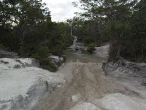
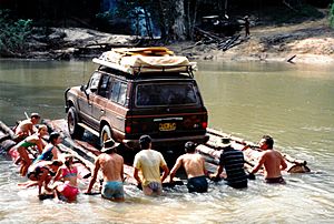
The Northern Peninsula Road now goes around the old overland telegraph line (OTL) track. This old track is often called the "tele track." It was used to build and maintain the telegraph line. Now, it's used by people with four-wheel drive vehicles in the dry season. Many river crossings, like the bridge over the Wenlock River, have been improved. However, many fords (places to cross a river) are still there. The roads are not paved and can be hard to drive on. They are only suitable for four-wheel-drive vehicles and only in the dry season.
In 1986, Cape York was suggested as a place for a spaceport. A group of companies, the Cape York Space Agency, supported this idea. The federal government also supported it. But in 1992, investors stopped supporting it. In 2017, the legal ownership of 160,000 hectares (400,000 acres) of land needed for the spaceport was given back to the Wuthathi, Kuku Yau, and Northern Kaanju people. If built, the spaceport would have included a new town, tourist resorts, an airport, and a harbor.
See also
 In Spanish: Península del cabo York para niños


