
Coral Gables, Florida facts for kids
Quick facts for kids
Coral Gables
|
|||
|---|---|---|---|

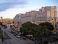
Coral Gables (in foreground) with Downtown Miami barely visible (in background) in 2010
|
|||
|
|||
| Nicknames:
"The City Beautiful", "The Gables"
|
|||

Location of Coral Gables in Miami-Dade County, Florida (left) and of Miami-Dade County in Florida (right)
|
|||

U.S. Census Bureau map showing city limits
|
|||
| Country | |||
| State | |||
| County | |||
| Incorporated | April 29, 1925 | ||
| Government | |||
| • Type | Commission-Manager | ||
| Area | |||
| • Total | 37.31 sq mi (96.64 km2) | ||
| • Land | 12.93 sq mi (33.48 km2) | ||
| • Water | 24.38 sq mi (63.16 km2) | ||
| Elevation | 10 ft (2.8 m) | ||
| Population
(2020)
|
|||
| • Total | 49,248 | ||
| • Estimate
(2022)
|
49,193 | ||
| • Rank | 61st in Florida | ||
| • Density | 3,804.56/sq mi (1,469.32/km2) | ||
| Time zone | UTC-5 (EST) | ||
| • Summer (DST) | UTC-4 (EDT) | ||
| Area codes | 305, 786, 645 | ||
| FIPS code | 12-14250 | ||
| GNIS feature ID | 0280801 | ||
| Website | www.coralgables.com | ||


Coral Gables is a city in Miami-Dade County, Florida, United States. It's part of the larger Miami metropolitan area in South Florida. The city is about 7 miles (11 km) southwest of Downtown Miami. In 2020, about 49,248 people lived there.
Coral Gables is famous for being home to the University of Miami. This is a large private research university. Its main campus covers 240 acres (97 ha) in the city. The University of Miami is the biggest employer in Coral Gables. It is also the second-largest employer in all of Miami-Dade County.
The city is a planned community with a special Mediterranean theme. It is known for its beautiful historic buildings and strict rules about how buildings can look. Many popular landmarks and tourist spots are found here.
Contents
History of Coral Gables
Coral Gables officially became a city on April 29, 1925. It was designed as a planned community. This design was based on the "City Beautiful Movement" from the early 1900s. The city still has very strict rules about how buildings are built.
Who Founded Coral Gables?
The city was created by George E. Merrick, a real estate developer from Pennsylvania. He developed Coral Gables during the "Florida land boom" in the 1920s. Merrick wanted the city's buildings to look like Mediterranean Revival style. This style often looks like old Spanish buildings. For example, the Coral Gables Congregational Church was built in this style. Merrick even donated the land for it. The Catholic Church of the Little Flower was built later in a similar Spanish Renaissance style.
Merrick dreamed of Coral Gables being like "Castles in Spain." He was so successful that Spain's King, Alfonso XIII, gave him an award. It was called the Order of Isabella the Catholic. This award recognized Merrick's support for Spanish culture in Coral Gables.
Growth and Development
By 1926, Coral Gables covered 10,000 acres (4,000 ha). It had made $150 million in sales. Over $100 million was spent on developing the city. That same year, the famous Biltmore Hotel and Golf Course opened. It is still a major landmark today.
Merrick carefully planned different areas of the city. For example, the Downtown shopping area was designed to be only four blocks wide. But it stretched for more than 2 miles (3.2 km). The main street, now called Miracle Mile, went right through the middle. Merrick made sure that every business was less than a two-block walk away.
The city once had an electric trolley system. It stopped running because more people started using cars. But now, a new free trolley system runs along Ponce de León Boulevard. It started in November 2003. Another special feature Merrick planned was the Coral Gables Villages. These villages were built in the 1920s. They showed different architectural styles like Italian, French, and Dutch South African.
University of Miami's Beginning
In 1925, around the same time Coral Gables was founded, the University of Miami was built. It was on 240 acres (97 ha) of land near U.S. Route 1. The first students started classes there in the fall of 1926. There were 372 students in that first class.
Coral Gables During World War II
During World War II, many Navy pilots and mechanics trained in Coral Gables. They also lived in the city.


Preserving History
Coral Gables has always cared a lot about saving its historic buildings. The city made its first preservation law in 1973. This was when many of its original buildings turned 50 years old. More rules were added later to create a Historic Preservation Board and Department. This department helps find important buildings and places. It lists them on the Coral Gables Registry of Historic Places. They also help make sure changes to historic buildings follow the rules.
Geography
Coral Gables is located in South Florida. It has borders on different sides. To the west, it's bordered by Red Road. To the north, it's bordered by Tamiami Trail/U.S. Route 41.
On the east, it's bordered by Douglas Road and LeJeune Road. Part of its eastern border is also Biscayne Bay. To the south, it's bordered by the Charles Deering Estate.
The city covers a total area of about 37.2 square miles (96.3 km2). Most of this area, about 24.0 square miles (62.2 km2), is water. The land area is about 13.1 square miles (33.9 km2).
Climate
Coral Gables has a tropical climate. This is similar to the weather found in many parts of the Caribbean. It's one of the few places in the United States with this type of climate. This means it's usually warm and humid, with a rainy season.
Population and People
As of 2020, Coral Gables had 49,248 people living there. There were 18,457 households and 11,087 families. In 2022, the average household income was estimated to be $118,203.
Things to Do in Coral Gables (Tourism)


Coral Gables is a great place to walk around. It's only about four miles from Miami International Airport. The city has around 140 places to eat and many international stores.
Some famous landmarks in Coral Gables include:
- The Venetian Pool
- Douglas Entrance
- The Miami Biltmore hotel
Media
The main daily newspaper for the area is The Miami Herald. Coral Gables also has its own local newspaper, Coral Gables News Tribune. It comes out twice a month. Students at the University of Miami publish their own newspaper, The Miami Hurricane, every Tuesday.
Economy

Coral Gables is home to some very wealthy areas in the United States. These include neighborhoods like Hammock Oaks and Gables Estates.
Major businesses and organizations that help the economy of Coral Gables include:
- The University of Miami: This is the largest employer in the city. It has over 16,000 staff and faculty.
- Baptist Hospital of Miami: This is the second-largest employer in Coral Gables.
- Bacardi: This company has its United States headquarters here.
- Fresh Del Monte Produce: This company also has its main office in Coral Gables.
- ExxonMobil: This large energy company has marine fuel operations here.
- MasTec, Inc.: This is one of the largest Hispanic-owned companies in the country.
- FIFA: The international soccer organization opened its North American headquarters in Coral Gables. This is to help prepare for the 2026 FIFA World Cup.
Transportation

You can get around Coral Gables using the Metrobus system. The Miami Metrorail also has stations in the city:
- Douglas Road station
- University station
Coral Gables also has a free trolley service. The trolley runs continuously along Ponce de Leon Boulevard during the day.
Diplomatic Offices
Several countries have offices called consulates in Coral Gables. These offices help their citizens and promote their country. Countries with consulates here include Barbados, Colombia, El Salvador, Italy, Peru, and Spain.
Some countries also have honorary consulates. These are usually run by people who live in Coral Gables. The Taipei Economic and Cultural Office for Taiwan is also located here.
Education


University of Miami
The University of Miami is a private university located in Coral Gables. It is known as one of the top universities in the country. It has strong programs in business, engineering, law, marine science, medicine, and music.
Schools for Kids
Public Schools
Schools in Coral Gables are part of the Miami-Dade County Public Schools system. The city has several high schools. These include Coral Gables Senior High School and International Studies Preparatory Academy. Both schools teach students from ninth to twelfth grade.
There is also a K–8 school called Coral Gables Preparatory Academy. It has two campuses, including a historic one. Henry S. West Laboratory Elementary is another school for grades K–6.
For middle school, there are two options: George Washington Carver Middle School and Ponce de Leon Middle School. George Washington Carver Middle School was named after George Carver in 1942.
Private Schools
Coral Gables has several private schools. These include Gulliver Academy, Marian C. Krutulis Campus, which is a PreK–8 school. The lower campus of Riviera Schools is also in Coral Gables.
Other private schools include St. Theresa Catholic School (Pre-K–8), St. Philip's Episcopal School (Pre-K–5), French-American School of Miami (Pre-K–5), and St. Thomas Episcopal Parish School (Pre-K–5).
Public Libraries
The Miami-Dade Public Library System runs the Coral Gables Branch Library in the city.
Famous People from Coral Gables
Many well-known people have lived in Coral Gables, including:
- Marc Anthony, a famous salsa singer
- Dave Barry, a humor writer who won a Pulitzer Prize
- Shane Battier, a former professional basketball player
- Jeb Bush, a former Governor of Florida
- Gail Edwards, an actress from TV shows like Full House
- Juan Ramón Jiménez, a Nobel Prize-winning author
- José José, a popular pop singer
- Alonzo Mourning, a former professional basketball player
- Mimi Rogers, an actress
- Jon Secada, a Latin pop singer
- Jonathan Vilma, a former professional football player
Cool Places to Visit
- Coral Gables Villages
- Coral Way
- Fairchild Tropical Botanic Garden
- Miami Biltmore Hotel
- Miracle Mile
- Shops at Merrick Park
- University of Miami
- Venetian Pool
Festivals and Events
Coral Gables hosts several fun events each year:
- Festival of Art, at the University of Miami, held in January
- Carnival on the Mile, on Miracle Mile, held in February or March
- Junior Orange Bowl Festival, held in December and January
Images for kids
-
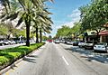
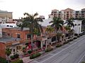
Miracle Mile in Downtown Coral Gables
-
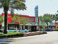
Miracle Theater on Miracle Mile
-
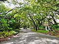
Typical residential street in Coral Gables
-
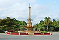
DeSoto Fountain
-
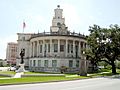
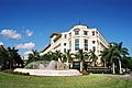
Coral Gables City Hall with its statue of Merrick
-
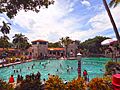
Venetian Pool is a Coral Gables public swimming pool.
-
Giralda Avenue in Coral Gables
-
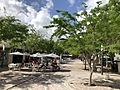
Giralda Plaza
-
Shops at Merrick Park
-
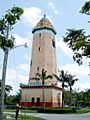
Alhambra Water Tower
-
Miracle Theater on Miracle Mile
-
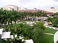
Gardens at Merrick Park
-
Ponce de Leon Boulevard
-
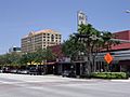
Downtown Coral Gables along Alhambra Circle


Sister Cities
Coral Gables has "sister city" relationships with several cities around the world:
 Aix-en-Provence, France
 Antigua Guatemala, Guatemala
 Cartagena, Colombia
 Quito, Ecuador
 San Isidro, Argentina
 Santa Tecla, El Salvador
 Seville, Spain
See also
 In Spanish: Coral Gables para niños
