Salt Lake County, Utah facts for kids
Quick facts for kids
Salt Lake County
|
||
|---|---|---|
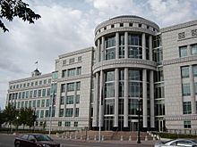
Utah Supreme Court at Scott M. Matheson Court House in Salt Lake City
|
||
|
||
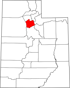
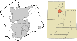
Location within the U.S. state of Utah
|
||
 Utah's location within the U.S. |
||
| Country | ||
| State | ||
| Founded | January 31, 1850 | |
| Named for | Great Salt Lake | |
| Seat | Salt Lake City | |
| Largest city | Salt Lake City | |
| Area | ||
| • Total | 807 sq mi (2,090 km2) | |
| • Land | 742 sq mi (1,920 km2) | |
| • Water | 65 sq mi (170 km2) 8.1% | |
| Population
(2020)
|
||
| • Total | 1,185,238 | |
| • Estimate
(2023)
|
1,185,813 |
|
| • Density | 1,598/sq mi (617/km2) | |
| Time zone | UTC−7 (Mountain) | |
| • Summer (DST) | UTC−6 (MDT) | |
| Congressional districts | 1st, 2nd, 3rd, 4th | |
Salt Lake County is found in the U.S. state of Utah. It is the most populated county in Utah. In 2020, about 1.2 million people lived here. Its main city and largest city is Salt Lake City, which is also the capital of Utah. The county was officially started in 1850. Salt Lake County is one of the most populated counties in the entire United States. It is also one of the few very populated counties in the Rocky Mountains.
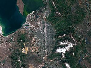
Salt Lake County is mostly in the Salt Lake Valley. This valley is surrounded by mountains. The Oquirrh Mountains are to the west. The Wasatch Range is to the east. The northwestern part of the county also touches the Great Salt Lake. The county is well-known for its ski resorts. Salt Lake City even hosted the 2002 Winter Olympics. Salt Lake County is the main part of the larger Salt Lake City metropolitan area. Recently, long periods of dry weather have made the Great Salt Lake water levels very low. This also affects the county's water supply.
Contents
History of Salt Lake County
This area was home to many different groups of native people for thousands of years.
Early Settlers and Growth
European Americans first settled the Salt Lake County area in 1847. These were Mormon pioneers from the Church of Jesus Christ of Latter-day Saints. They came to the Salt Lake Valley to escape religious problems in the East. Their leader, Brigham Young, said "This is the place" when he saw the valley.
The valley seemed dry to some settlers. But they used irrigation to grow crops. This helped them build a successful city called Great Salt Lake City. Many more Mormons moved here in the years that followed.
The county was officially set up on January 31, 1850. At that time, over 11,000 people lived here.
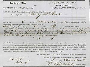
The federal government had some disagreements with Utah Territory. So, a federal surveyor left his job in 1857. This person was supposed to map the land. Without him, settlers couldn't officially claim land. So, the Mormon pioneers made their own maps and land records. These were called Land Title Certificates. They helped people own land and pay taxes.
In 1850, the area became the Utah Territory. The capital was first in Fillmore. But in 1857, Salt Lake City became the capital. In 1858, the government sent soldiers to Utah. They set up Camp Floyd and later Fort Douglas. These forts helped the federal government keep an eye on the area. In 1868, "Great" was removed from the county and city names. That's how they got their modern names.
Mining and Railroads
Patrick Edward Connor was a leader at Fort Douglas. He wanted more non-Mormons to move to Utah. So, he sent people to look for minerals in the mountains. Mines were started in the Wasatch mountains. One famous area was around Alta. Getting minerals out was hard until the Utah Central Railroad arrived in 1870.
The Bingham Canyon Mine in the Oquirrh Mountains became very important. It had huge amounts of copper and silver. This mine brought thousands of workers to the area. At its busiest, the town of Bingham Canyon had 20,000 people. Most mines in the county closed by the early 1900s. But the Bingham Canyon Mine kept growing. Today, it is one of the largest open-pit mines in the world.
Growth in the 20th Century
After the railroad came, more people moved to Salt Lake County. New industries also came to the valley. This made the economy more diverse. Trolley systems were built to help people get around. But by 1945, people started using cars more. So, the trolley system was removed.
During World War II, a large military base called Kearns Army Air Base was built. After the war, this land was sold for homes. Many people moved to the area. Other military bases were also built nearby. This helped the economy and brought more people to Utah. Cities like South Salt Lake, Murray, and Midvale grew very fast.
In the 1960s, many people moved from Salt Lake City to the new suburbs. Cities like Sandy and West Jordan grew quickly in the 1970s and 1980s. Farmland turned into new neighborhoods. West Valley City was formed in 1980 by joining three smaller towns.
Some mining towns, like Bingham Canyon, were removed in the 1960s and 1970s. This made space for the mine to grow. Today, Copperton is the only mining town left in the county.
In the 1990s, growth moved to the south and west parts of the county. Cities like South Jordan and Draper became some of the fastest-growing cities in Utah. Salt Lake City also gained population for the first time in 40 years.
Salt Lake County in the 21st Century
Salt Lake City hosted the 2002 Winter Olympics. This led to a lot of new building projects. The county has become very urbanized. Only a few rural areas are left in the far west. Today, the county faces challenges like traffic and air pollution.
Geography and Nature
The Salt Lake Valley gets water from seven streams. All this water flows into the Great Salt Lake. The lake has no outlet, meaning water only leaves by evaporating. The mountains around the valley are very steep. This shows they are relatively new in terms of geology.
Salt Lake County covers about 807 square miles. Most of this is land, and about 65 square miles is water. It is one of the smaller counties in Utah. The Jordan River flows north through the county.
The Wasatch Mountains are a very important part of the county. They are famous for both summer and winter fun. These mountains are part of the Wasatch-Cache National Forest. The snow here is called 'Greatest Snow on Earth' because it is light and powdery. This helped Salt Lake City win the bid for the 2002 Winter Olympics.
Salt Lake County has four ski resorts:
- Snowbird
- Alta (in Little Cottonwood Canyon)
- Solitude
- Brighton (in Big Cottonwood Canyon)
Hiking and camping are popular in the summer. The Oquirrh Mountains are on the western side of the county. These mountains, along with the smaller Traverse Mountains to the south, form the Salt Lake Valley. The Great Salt Lake is to the northwest.
On the north and east sides of the valley, houses are built high up the mountains. This means they are closer to the national forest. New communities are also being built on the southern and western slopes. Fast growth continues in many parts of the valley. This growth can affect the natural environment. The county government runs several large parks, like Big Cottonwood Park.
How to Get Around
Getting into the Salt Lake Valley is mainly through four narrow areas. These are Parley's Canyon to the east, the area near the Great Salt Lake to the north, the Point of the Mountain to the south, and a space near the Oquirrh Mountains to the west. These routes form a cross shape for transportation.
Air Travel
Salt Lake City International Airport is the main airport for passenger flights. South Valley Regional Airport is another public airport. Salt Lake City International Airport is one of the busiest airports in the United States. It is a major hub for Delta Air Lines. The airport has been undergoing a big renovation project since 2014.
Trains
Amtrak's California Zephyr train runs daily through Salt Lake City Station. It connects California and Chicago.
The Utah Transit Authority (UTA) has a train system called FrontRunner. This train connects Salt Lake County to Ogden in the north and Provo in the south.
UTA also runs a light rail system called TRAX. It has three lines:
- The Blue Line goes from Downtown Salt Lake City to Draper.
- The Red Line goes from South Jordan to the University of Utah.
- The Green Line goes from West Valley City to the Salt Lake City International Airport.
TRAX opened in 1999. New lines and extensions have been added over the years. A modern streetcar line, the S Line, also opened in 2013 in the Sugar House neighborhood.
Roads
Salt Lake County has several major roads:
- I-15 goes north to south through the valley. It is 10-12 lanes wide in many places.
- I-80 goes east to west. It crosses I-15 near Downtown Salt Lake City.
- I-215 is a loop that serves many suburbs.
- US-89, also known as State Street, is a main surface road.
- Bangerter Highway is an expressway on the western side of the valley.
The Utah Transit Authority also runs bus routes throughout the valley. These buses connect to nearby cities and ski resorts in winter.
Walking and Biking Trails
The Jordan River Parkway trail runs north to south through the valley. The planned Crosstown and Parley's trails will create a main east-west route. The Bonneville Shoreline Trail runs along the Wasatch mountains. Many other trails are in the Wasatch-Cache National Forest.
Neighboring Counties
- Davis County – north
- Morgan County – northeast
- Summit County – east
- Wasatch County – southeast
- Utah County – south
- Tooele County – west
Climate and Weather
Salt Lake Valley gets about 15 inches of rain each year. The east side usually gets more rain. Most rain falls in spring. Summers are dry, but sometimes thunderstorms happen from the monsoon season. These storms can cause flash floods or wildfires.
The valley gets about 55 inches of snow each year. The mountains get much more, up to 500 inches. This light, dry snow is great for skiing. Snow usually falls from October to May. The lake effect from the Great Salt Lake can make snow heavier.
In winter, temperature inversions are common. This means cold air and pollution get trapped in the valley. The mountains above are clear and warm. This can lead to unhealthy air quality in the valley.
Population and People
Salt Lake County is home to a diverse group of people. In 2020, the county had 1,185,238 residents.
| Race or Ethnicity | 2020 | 2010 | 2000 | 1990 | 1950 | 1900 |
|---|---|---|---|---|---|---|
| White | 71.5% | 81.2% | 92.0% | 93.1% | 98.6% | 99.2% |
| —Non-Hispanic | 67.6% | 73.9% | 78.1% | 89.9% | n/a | n/a |
| Black or African American | 2.0% | 1.6% | 1.3% | 0.8% | 0.4% | 0.4% |
| Hispanic or Latino (of any race) | 19.6% | 17.1% | 14.7% | 5.9% | 3.1% | n/a |
| Asian | 4.3% | 3.3% | 2.9% | 2.0% | 0.7% | n/a |
| Hawaiian & Pacific Islander | 1.8% | 1.5% | 1.3% | 0.7% | n/a | n/a |
| Native American | 1.1% | 0.9% | 0.9% | 0.9% | 0.7% | 0.01% |
| Multiracial | 9.9% | 3.1% | 1.5% | n/a | n/a | n/a |
The 2000 census was the first to allow residents to select multiple race categories. Before 2000, the census used the category 'Other Race' as a general group. For county data in 1950 and 1900, Utah counted all non-White and non-Black residents using this category. Asian and Hispanic Americans were counted by where their families came from.
In 2020, about 67.6% of people were White (not Hispanic or Latino). About 19.6% of people were Hispanic or Latino. The median age was 32.9 years old. This means half the people were younger than 32.9, and half were older.
The average household size was 2.92 people. The median income for a household was $77,128. This means half of the households earned more than this, and half earned less.
Religion in Salt Lake County
In 2008, about 50.6% of Salt Lake County's population were members of the Church of Jesus Christ of Latter-day Saints (LDS). By 2020, this number had gone down to 46.89%.
Economy and Jobs
The economy of Salt Lake County used to be mainly about LDS services and mining. While these are still important, their role has changed. Since World War II, defense industries have also been very important. This is because of the county's central location and the large, empty Great Salt Lake Desert nearby. This desert is used for training and testing.
Skiing and other winter sports became a big part of the economy starting in 1939. The 2002 Winter Olympics helped tourism and the economy a lot. It also greatly improved transportation. Since the 1960s, the economy has shifted more towards services. In the 1980s and 1990s, technology companies started to arrive. Companies like Overstock.com are still important businesses here.
Northrop Grumman, a big company, builds rocket parts in Magna.
Education and Learning
Salt Lake County has several colleges and universities. The University of Utah is a major research university. Westminster College and Salt Lake Community College also have large campuses.
The county has five public school districts:
- Salt Lake City
- Canyons
- Granite
- Jordan
- Murray
Salt Lake City and Murray have their own school districts. The Granite School District is the third largest in Utah. It covers areas like Magna and West Valley City. The Jordan School District covers the southwest part of the county. This includes cities like West Jordan and Herriman.
In 2007, residents on the east side of the Jordan School District voted to create the Canyons School District. This included cities like Sandy and Draper.
| School | District | Location |
|---|---|---|
| Alta High School | Canyons | Sandy |
| Bingham High School | Jordan | South Jordan |
| Brighton High School | Canyons | Cottonwood Heights |
| Copper Hills High School | Jordan | West Jordan |
| Corner Canyon High School | Canyons | Draper |
| Cottonwood High School | Granite | Murray |
| Cyprus High School | Granite | Magna |
| East High School | Salt Lake City | Salt Lake City |
| Granger High School | Granite | West Valley City |
| Herriman High School | Jordan | Herriman |
| Highland High School | Salt Lake City | Salt Lake City |
| Hillcrest High School | Canyons | Midvale |
| Hunter High School | Granite | West Valley City |
| Jordan High School | Canyons | Sandy |
| Kearns High School | Granite | Kearns |
| Mountain Ridge High School | Jordan | Herriman |
| Murray High School | Murray | Murray |
| Olympus High School | Granite | Holladay |
| Riverton High School | Jordan | Riverton |
| Skyline High School | Granite | Millcreek |
| Taylorsville High School | Granite | Taylorsville |
| West High School | Salt Lake City | Salt Lake City |
| West Jordan High School | Jordan | West Jordan |
Two high schools have closed:
- South High School in Salt Lake City closed in 1988. Now it is part of Salt Lake Community College.
- Granite High School in South Salt Lake closed in 2009. The building was torn down in 2018. Now, a Salt Lake County Library branch is there.
The Roman Catholic Diocese of Salt Lake City also runs several schools in the county. Judge Memorial Catholic High School and Juan Diego Catholic High School are two Catholic high schools.
Salt Lake County also has several independent schools. The Bastian Agricultural and Equestrian Center is here too. It is also a place for Utah State University to offer classes.
Cities and Towns
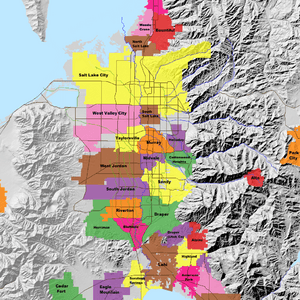
Cities
- Bluffdale
- Cottonwood Heights
- Draper
- Emigration Canyon
- Herriman
- Holladay
- Kearns
- Magna
- Midvale
- Millcreek
- Murray
- Riverton
- Salt Lake City (county seat)
- Sandy
- South Jordan
- South Salt Lake
- Taylorsville
- West Jordan
- West Valley City
- White City
Towns
Unincorporated Communities
- Mount Aire
- Oquirrh, Utah
Former Communities
- Bingham Canyon: This town was removed in 1971 to make way for the expanding mine.
- Lark: This small town was taken down in 1978 for the mine's waste.
Notable People from Salt Lake County
- Parley Parker Christensen: A politician from Utah and California.
- John Paul Kennedy: A retired court judge.
See also
 In Spanish: Condado de Salt Lake para niños


