Geography of Pennsylvania facts for kids
The geography of Pennsylvania is very diverse. It ranges from low-lying areas near the ocean to high mountains and plateaus. This state is known for its natural resources, its important ports, and the big part it played in the founding of the United States.
Contents
Major Features of Pennsylvania
Pennsylvania is often called the "Keystone State." This nickname comes from its central location, acting like a bridge. It connects the Northeastern United States with the Southern United States. It also links the East Coast with the Midwest. The state even touches the Great Lakes at Erie.
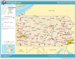
Pennsylvania shares borders with several states and a large lake. To the north and northeast, it borders New York. To the east, it borders New Jersey. To the south, you'll find Delaware, Maryland, and West Virginia. On the west, it borders Ohio. To the northwest, it touches Lake Erie. It also has a small border on Lake Erie with Canada.
The main rivers in Pennsylvania are the Delaware, Susquehanna, Monongahela, Allegheny, and Ohio. Smaller but important rivers include the Lehigh River in the east and Oil Creek in the west. These smaller rivers were very important for Pennsylvania's early industries. Pennsylvania was one of the original 13 colonies.
The state is about 180 miles (290 km) from north to south. It is about 310 miles (500 km) from east to west. Its total land area is about 44,817 square miles (116,075 km²). About 739,200 acres (2,991 km²) of this area are water. Pennsylvania is the 33rd largest state in the United States. The highest point in the state is Mount Davis, which is 3,213 feet (979 m) above sea level. The lowest point is at sea level along the Delaware River.
Regions of Pennsylvania
Pennsylvania Dutch Country
The Pennsylvania Dutch region is in south-central Pennsylvania. It is a popular place for visitors. The Pennsylvania Dutch people include groups like the Amish and Mennonites. They live mostly in rural areas around Lancaster, York, and Harrisburg. Some of these groups avoid modern conveniences. They use horse-drawn farm equipment and carriages. Other groups are harder to tell apart from people who are not Amish or Mennonite.
Even though they are called "Dutch," these people actually came from parts of southwest Germany, Alsace, and Switzerland. The word "Dutch" used to mean "German" in old English.
Western Pennsylvania's Unique Features
Western Pennsylvania makes up about one-third of the state. It is a unique area with its own features. Several things make Western Pennsylvania different from the eastern part. It was hard to reach because of the mountains. Its rivers flow towards the Mississippi River. The area also had a big role in the American steel industry. This industry was centered around Pittsburgh, which is the state's second-largest city.
Other things that make Western Pennsylvania special include its different style of farming. It also saw the rise of the oil industry and timber use. Even the local way of speaking, called Pittsburgh English, sets it apart.
The Mountains of Pennsylvania
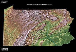
Pennsylvania is cut diagonally by the Appalachian Mountains. These mountains made travel difficult in the past. People often had to follow old Native American trails along river paths. They could only pass through certain spots called water gaps. However, the valleys in central Pennsylvania are connected by the Susquehanna River and its smaller rivers. This allowed for canals to be built in the 1830s.
To the northwest of these folded mountains is the Allegheny Plateau. This plateau sits above a steep edge called the Allegheny Front. It continues into New York. The plateau has valleys formed by small streams. The height difference between valley floors and hilltops is usually a few hundred feet.
Underneath the plateau are sedimentary rocks. These rocks have many fossils and important minerals. These include iron, natural gas, coal, and petroleum. These resources helped local industries grow from the 17th to the 19th centuries.
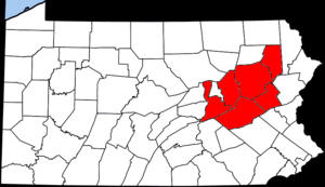
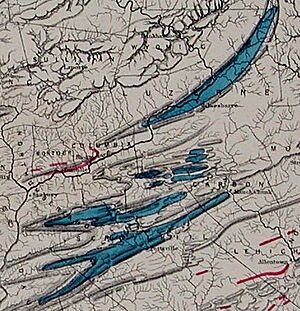
To the south and east of the plateau are the folded mountains and valleys. These are known as the Ridge-and-Valley Appalachians. They stretch from the southern Appalachians up to northern New England. In Northeastern Pennsylvania, east of Harrisburg, these ridges hold the world's richest deposits of anthracite coal. This area is called the Coal Region. This coal was very important for the American Industrial Revolution.
In 1859, Edwin L. Drake drilled the first oil well in the U.S. near Titusville. Similar rock layers also contain coal. In the folded mountain belt, hard coal (anthracite) is mined near Wilkes-Barre and Hazelton. These fossil fuels have been a key resource for Pennsylvania. Timber and dairy farming are also important ways people make a living in central and western Pennsylvania. You can find orchards and vineyards along the shore of Lake Erie in the far northwest.
During the last Ice Age, parts of northeastern and northwestern Pennsylvania were covered by glaciers. These glaciers reached into the Appalachian valleys but did not cover the mountain tops. At their largest, they spread as far south as Moraine State Park, which is about 40 miles (64 km) north of Pittsburgh.
The Shores of Pennsylvania
Pennsylvania has about 57 miles (92 km) of shoreline along the Delaware River estuary. This includes the busy Port of Philadelphia, which is one of the largest seaports in the U.S. Chester, located downstream, is also an important port. The tidal marsh along Pennsylvania's only saltwater shore is protected as the John Heinz National Wildlife Refuge at Tinicum.
Pennsylvania also has a narrow inland freshwater shore at Erie. This is where the Great Lakes meet Lake Erie in the Erie Triangle.
In the west, the Port of Pittsburgh is very large. It even handles more goods by weight than Philadelphia each year. This is because a lot of coal is shipped by barge down the Ohio River.
Ecological Challenges
Pennsylvania has faced several environmental challenges since the 1800s.
- In 1889, the South Fork Dam broke after heavy rain. This dam held back a lake used for recreation. The flood destroyed the factory town of Johnstown downstream. Over 2,200 people died in this famous Johnstown Flood. The town was later rebuilt.
- In 1948, a weather event over Donora trapped pollution from nearby metal factories. This caused 20 deaths and made many more people sick.
- In 1961, an exposed coal seam in Centralia caught fire. This underground coal fire is still burning today. It forced almost everyone in the community to leave. Experts believe it could burn for another 250 years.
- In 1979, there was an incident at the Three Mile Island Nuclear Power Plant. This happened near Harrisburg, the state capital. While it did not destroy the community, the cleanup cost nearly $1 billion. It also made many people in the country feel less positive about nuclear power.
Climate of Pennsylvania
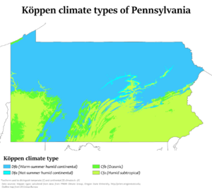
Pennsylvania has three main climate regions. These are mostly determined by how high up an area is, not just how far north or south it is. Most of the state has a humid continental climate. This means it has cool to cold winters and hot, humid summers. This is true for most major cities.
Higher areas have a more severe continental climate. They have warm, humid summers and cold, snowy winters. The far southeastern part of Pennsylvania, around Philadelphia, has a humid subtropical climate. This means it has milder winters and hot, humid summers.
There is plenty of rain and snow throughout the state. The main weather influences come from the Atlantic Ocean, the Gulf of Mexico, and cold air from the Arctic that crosses over the Great Lakes.
See also
 In Spanish: Geografía de Pensilvania para niños
 | Emma Amos |
 | Edward Mitchell Bannister |
 | Larry D. Alexander |
 | Ernie Barnes |


