Gila County, Arizona facts for kids
Quick facts for kids
Gila County
|
|||
|---|---|---|---|
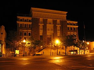
Gila County Courthouse in Globe
|
|||
|
|||
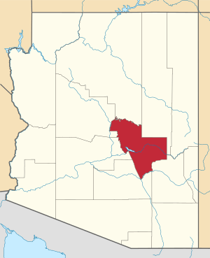
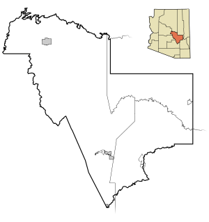
Location within the U.S. state of Arizona
|
|||
 Arizona's location within the U.S. |
|||
| Country | |||
| State | |||
| Founded | February 8, 1881 | ||
| Named for | Gila River | ||
| Seat | Globe | ||
| Largest town | Payson | ||
| Area | |||
| • Total | 4,795 sq mi (12,420 km2) | ||
| • Land | 4,758 sq mi (12,320 km2) | ||
| • Water | 38 sq mi (100 km2) 0.8%% | ||
| Population
(2020)
|
|||
| • Total | 53,272 | ||
| • Estimate
(2023)
|
54,003 |
||
| • Density | 11.1099/sq mi (4.2896/km2) | ||
| Time zone | UTC−7 (Mountain) | ||
| Congressional district | 2nd | ||
Gila County is a county in the central part of Arizona, a state in the U.S.. In 2020, about 53,272 people lived here. The main town and county seat (where the county government is) is Globe.
Gila County is part of the larger Phoenix–Mesa, AZ combined statistical area. It also includes parts of the Fort Apache Indian Reservation and San Carlos Indian Reservation.
Contents
History of Gila County
Gila County was created on February 8, 1881. It was formed from parts of Maricopa and Pinal counties. Later, in 1889, its border was moved eastward to the San Carlos River. The first county seat was in a mining town called Globe City, which is now Globe.
The name "Gila" is thought to come from a Yuma word. This word, "Hah-quah-sa-eel," means "running water which is salty." The Spanish then shortened it to "Gila."
Past Conflicts and Important Rulings
In the 1880s, a big conflict happened in Gila County. It was called the Pleasant Valley War. This was a long disagreement between families who raised cattle (the Grahams) and families who raised sheep (the Tewksburys). This conflict was about land and resources.
Many people were involved, and some lost their lives. Frederick Russell Burnham, a famous scout, was part of this conflict. Another well-known person, Tom Horn, was also involved. No one was ever charged for the events of this war.
In the 1960s, Gila County was home to a young person named Gerald Gault. His case led to a very important U.S. Supreme Court decision in 1967. This ruling, called in re Gault, said that young people have the same rights as adults when they are arrested. This means they have rights to know what they are accused of. They also have rights to lawyers and for their families to be told about their arrest. They can also face the people who accuse them. This ruling made sure young people are treated fairly in the legal system.
Geography of Gila County
Gila County covers a total area of about 4,795 square miles. Most of this area, about 4,758 square miles, is land. The rest, about 38 square miles, is water. This means water makes up about 0.8% of the county's total area.
Neighboring Counties
Gila County shares its borders with several other counties:
- Yavapai County to the northwest and north
- Maricopa County to the west
- Pinal County to the south
- Graham County to the south
- Navajo County to the east and northeast
- Coconino County to the north
Protected Natural Areas
Parts of these national forests and monuments are located in Gila County:
- Coconino National Forest
- Tonto National Forest
- Tonto National Monument
Population and People
| Historical population | |||
|---|---|---|---|
| Census | Pop. | %± | |
| 1890 | 2,021 | — | |
| 1900 | 4,973 | 146.1% | |
| 1910 | 16,348 | 228.7% | |
| 1920 | 25,678 | 57.1% | |
| 1930 | 31,016 | 20.8% | |
| 1940 | 23,867 | −23.0% | |
| 1950 | 24,158 | 1.2% | |
| 1960 | 25,745 | 6.6% | |
| 1970 | 29,255 | 13.6% | |
| 1980 | 37,080 | 26.7% | |
| 1990 | 40,216 | 8.5% | |
| 2000 | 51,335 | 27.6% | |
| 2010 | 53,597 | 4.4% | |
| 2020 | 53,272 | −0.6% | |
| 2023 (est.) | 54,003 | 0.8% | |
| U.S. Decennial Census 1790–1960 1900–1990 1990–2000 2010–2020 |
|||
2020 Census Information
The 2020 census showed that Gila County had a population of 53,272 people. The table below shows the different racial and ethnic groups living in the county. It's important to know that the U.S. Census counts Hispanic/Latino people as an ethnic group, and they can be of any race.
| Race / Ethnicity (NH = Non-Hispanic) | Pop 2000 | Pop 2010 | Pop 2020 | % 2000 | % 2010 | % 2020 |
|---|---|---|---|---|---|---|
| White alone (NH) | 35,391 | 35,298 | 32,757 | 68.94% | 65.86% | 61.49% |
| Black or African American alone (NH) | 174 | 195 | 239 | 0.34% | 0.36% | 0.45% |
| Native American or Alaska Native alone (NH) | 6,412 | 7,615 | 8,655 | 12.49% | 14.21% | 16.25% |
| Asian alone (NH) | 211 | 256 | 427 | 0.41% | 0.48% | 0.80% |
| Pacific Islander alone (NH) | 24 | 34 | 45 | 0.05% | 0.06% | 0.08% |
| Other race alone (NH) | 36 | 38 | 203 | 0.07% | 0.07% | 0.38% |
| Mixed race or Multiracial (NH) | 541 | 573 | 1,663 | 1.05% | 1.07% | 3.12% |
| Hispanic or Latino (any race) | 8,546 | 9,588 | 9,283 | 16.65% | 17.89% | 17.43% |
| Total | 51,335 | 53,597 | 53,272 | 100.00% | 100.00% | 100.00% |
2010 Census Information
In 2010, there were 53,597 people living in Gila County. There were 22,000 households, with about 14,294 of them being families. The population density was about 11.3 people per square mile.
Most people, about 76.8%, identified as white. About 14.8% were American Indian. Other groups included Asian (0.5%), Black or African American (0.4%), and Pacific Islander (0.1%). About 17.9% of the population was of Hispanic or Latino origin.
The average age of people in Gila County was 47.9 years old.
Transportation
Main Highways
These are the major roads that go through Gila County:
 U.S. Route 60
 U.S. Route 70
 State Route 77
 State Route 87
 State Route 188
 State Route 260
Airports
You can find these public airports in Gila County:
Communities
City
- Globe (This is the county seat)
Towns
- Hayden (partly in Pinal County)
- Miami
- Payson
- Star Valley
- Winkelman (partly in Pinal County)
Census-Designated Places (CDPs)
These are areas that are like towns but are not officially incorporated as cities or towns.
- Bear Flat
- Beaver Valley
- Canyon Day
- Carrizo
- Cedar Creek
- Central Heights-Midland City
- Christopher Creek
- Claypool
- Copper Hill
- Cutter
- Deer Creek
- Dripping Springs
- East Globe
- East Verde Estates
- El Capitan
- Flowing Springs
- Freedom Acres
- Geronimo Estates
- Gisela
- Haigler Creek
- Hunter Creek
- Icehouse Canyon
- Jakes Corner
- Kohls Ranch
- Mead Ranch
- Mesa del Caballo
- Oxbow Estates
- Peridot
- Pinal
- Pine
- Rock House
- Roosevelt
- Roosevelt Estates
- Round Valley
- Rye
- San Carlos
- Six Shooter Canyon
- Strawberry
- Tonto Basin
- Tonto Village
- Top-of-the-World
- Washington Park
- Wheatfields
- Whispering Pines
- Young
Other Communities
Ghost Towns
These are towns that no longer have people living in them.
Indian Communities
Education
Gila County has several school districts that serve its students:
Unified School Districts
These districts include both elementary and high schools:
- Globe Unified School District
- Hayden-Winkelman Unified School District
- Miami Unified School District
- Payson Unified School District
- San Carlos Unified School District
- Whiteriver Unified School District
Elementary School Districts
These districts focus on elementary education:
- Pine Strawberry Elementary School District
- Tonto Basin Elementary School District
- Young Elementary School District
Notable People
Some well-known people from Gila County include:
- George W. P. Hunt
- David Gowan
- Rose Mofford
See also
 In Spanish: Condado de Gila para niños
 | May Edward Chinn |
 | Rebecca Cole |
 | Alexa Canady |
 | Dorothy Lavinia Brown |


