
Lake Kankakee facts for kids
Quick facts for kids Lake Kankakee |
|
|---|---|
_Grn_on_grn.jpg)
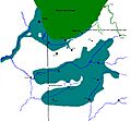
Lake Kankakee based on Barrett, Edward, 1916
|
|

Lake Kankakee
Location in the United States
|
|
| Location | North America |
| Group | Great Lakes |
| Coordinates | 41°13′N 86°58′W / 41.22°N 86.96°W |
| Primary inflows | Wisconsin Glacier |
| Primary outflows | Kankakee River |
| Catchment area | l |
| Basin countries | Canada United States |
| Max. length | 50 mi (80 km) |
| Max. width | 50 mi (80 km) |
| Average depth | 40 ft (12 m) |
| Max. depth | 45 ft (14 m) |
| Surface elevation | 560 ft (171 m) |
Lake Kankakee was a huge lake that existed a very long time ago, about 14,000 years ago! It formed in the valley of the Kankakee River in Northwest Indiana. This happened when giant ice sheets, called glaciers, started to melt and shrink.
The lake was created by meltwater from three big parts of the Wisconsin glaciation (a period when much of North America was covered by ice). These ice sheets were the Michigan Lobe, Saginaw Lobe, and Huron-Erie Lobe. They formed a giant bowl-like area across Indiana.
Around 13,000 years ago, the lake started to drain. It eventually reached a certain level because of a natural limestone ridge called the Momence Ledge. This ridge acted like a dam, holding water in the upper part of the basin. This created the famous Grand Kankakee Marsh.
Lake Kankakee is known as a prehistoric lake. It existed during the Pleistocene Era, which was the last Ice Age. The lake formed when the Michigan and Saginaw parts of the glacier had melted back to areas known as the Valparaiso Moraine and Kalamazoo Moraine. Even though the glaciers weren't moving forward much, the summer meltwater created a huge lake. This lake covered parts of 13 counties in two different states!
In the 1840s, a person named F. H. Bradley gave the lake its name, Lake Kankakee. He believed a large lake once filled the Kankakee area. He noticed sand deposits outside the marsh, which were a big clue. These sands were moved by wind, not by lake water or rivers. Bradley estimated the lake would have been about 685 feet (209 m) above sea level.
Contents
How Lake Kankakee Formed
.jpg)
The glaciers weren't completely still. They were melting at the same speed that new ice was pushing down from the north. This meant their edges stayed in roughly the same place. The melting ice created huge amounts of water.
Water from the eastern side of the Michigan Lobe and the western side of the Saginaw Lobe flowed through the Dowagiac River valley in western Michigan. This water joined the ancient St. Joseph River. The river's flow actually reversed, heading south towards the flat land where South Bend is today. From the east, the St. Joseph River valley also collected meltwater from the Saginaw Lobe and the Huron-Erie Lobe.
The Valparaiso Moraine was like a southern wall for the Michigan Lobe. It also formed the northern edge of the Kankakee Valley. The Dowagiac River valley stretched north between the Valparaiso Moraine (on the west) and the Kalamazoo Moraine (on the east). The Kalamazoo Moraine was another side of the melting Saginaw Lobe.
The meltwater from the St. Joseph valley flowed across the flat land south and east of South Bend, Indiana. It then entered the valley of the Kankakee River. Water from the Huron-Erie Lobe came through the upper Tippecanoe valley. This water spread across the flat land in Starke, Pulaski, Jasper, and Newton counties. It then joined the shallow waters in the Kankakee basin, covering parts of St. Joseph, LaPorte, Porter and Lake counties.
The meltwaters were trapped between the ice to the north and east. To the south, the Nebo-Gilboa Ridge (part of the Bloomington Moraine) and the Marseilles moraine acted as barriers. To the west, the Marseilles moraine was the final and lowest barrier. Near Marseilles, Illinois, the water eventually flowed over this barrier. This created an outlet into the ancient Mississippi River, forming the modern Illinois River. This huge flood of water is known as the Kankakee Torrent.
What Lake Kankakee Looked Like
Lake Kankakee was enormous! It covered more than 3,000 square miles (7,800 km2) of northern Indiana and the border of Illinois. The lake actually had two main open areas of water. These were separated by the Iroquois Moraine, which stuck out like a peninsula from the west.
The northern part of the lake stretched from just west of Momence, Illinois, along the main part of the Kankakee River. It went all the way to the marshy areas southwest of South Bend, Indiana. The southern part of the lake stretched from near Watseka, Illinois eastward to the Tippecanoe River. These two large water areas were connected by about 35 miles (56 km) of flat land, west of the Tippecanoe River. Even the valley of the Tippecanoe River, from Monticello, north past Winimac and reaching to Rochester, was part of this giant lake.
How the Lake Changed Over Time
Around 15,000 years ago, the Michigan part of the glacier had melted back. It was along a line from Wisconsin, about 30 miles (48 km) inland from Lake Michigan. It curved south around Chicago, through Indiana, and then north into Michigan. Meanwhile, the Huron-Saginaw part of the glacier had melted back to a line in Michigan, extending from Holland eastward through Kalamazoo to Jackson.
By 14,000 years ago, the glaciers had completely cleared the Kankakee River valley of ice. At this point, the ice moving from the north was melting at the same rate. This meant the glacier stayed in place, but it kept releasing huge amounts of water, sand, and silt into the valley. This water created Lake Kankakee. It flooded an area from Momence, Illinois upstream to South Bend, Indiana. A southern pool also reached from Watseka, Illinois east to Monticello and Winamac, Indiana.
When a lake drains or the land rises, the materials deposited in the lake water become dry land. Most of the soils around the Kankakee area are loamy. This means they are a mix of clay, silt, and sand. The flat land where the water flowed out (the outwash plain) has sand underneath, with layers of gravel.
The strong westerly winds started to affect 'Lake Kankakee' just like they affect the shores of Lake Michigan today. Sand dunes began to form along the south and eastern shorelines. Where large chunks of ice had been left behind and melted, sand filled in these hollows. Water flowing from the Valparaiso Moraine also built ridges of sand that led into the lake. On the south side, the winds continued to build up sand dunes.
As the glacier melted further north, the amount of water flowing into the lake decreased. The lake slowly drained and filled in. Because the water couldn't easily cut through the hard limestone ridge at Momence, Lake Kankakee eventually became a huge marshland. This marsh covered about 500,000 acres (202,346 hectares)!
Sand Dunes from the Wind
The sand dunes formed by wind (called Aeolian sands) mark the southern edge of Lake Kankakee. These sands were blown inland from the shoreline by the wind. This sandy area starts in the northeast, along the Maxinkuckee moraine of the Saginaw ice lobe. You can find it in Marshall County, Indiana, near Lake Maxinkuckee and Culver, Indiana. While some dunes are on the moraine itself, most of the sand beds are along its western edge.
The Maxinkuckee moraine follows the north side of the Tippecanoe River into Fulton County, heading east towards Rochester. The southeastern edge of these sands then swings south and west through Cass County. It goes west of Logansport, then turns west again, passing about 9 miles (14 km) north of Lake Cicott. Here, a sand ridge forms the eastern border of the flat land, sloping westward to the Tippecanoe River. This ridge continues westward in a steady line to the Tippecanoe Valley at Monticello. This ridge is like a side moraine, formed between the Saginaw lobe to the north and the Erie lobe to the south. The ridge continues westward and becomes harder to see as it passes west of Kentland, Indiana.
Where the Lake Drained Out
Lake Kankakee was over 40 feet (12 m) higher than the Kankakee River is today. It flowed over the western divide near Morris, Illinois. Here, another lake had formed as the glacier moved away from the Marseilles moraine.
At first, this water flowed through many gaps in the moraine, at elevations of 640 feet (200 m) to 650 feet (200 m) above sea level. Eventually, one gap, which is now part of the Illinois River, dropped lower than the others. This became the main outlet for both this lake and Lake Kankakee.
This outlet crosses exposed bedrock, which means it was a very long and slow process for the water to carve its way through. This shows that both lakes were held back for a long time. The terraces and beaches in the Morris Basin are about 560 feet (170 m) above sea level. This is about 60 feet (18 m) higher than the start of the Illinois River today. This proves that this lake existed during the time the Valparaiso Moraine was forming.
The level of Lake Kankakee extended up the Kankakee River Valley as far as Braidwood, where the sand dunes began. Once this break in the Marseilles moraine was created, it also became the outlet for Lake Chicago (another ancient lake). Combined with the waters from Lake Wauponsee, the outlet became deeper.
At this time, Lake Kankakee was draining a lot of water from the St. Joseph River's watershed, which was fed by the Saginaw glacier. The massive amount of water eroding the land created many of the features we see along the Illinois River and the lower Kankakee River. The rock barrier at Momence stopped the erosion from going further upstream. The various lakes formed by the melting glaciers were at their highest levels during this period. The main outlet was at or above 650 feet (200 m) above sea level.
Images for kids
-
Lake Kankakee based on Barrett, Edward, 1916
-
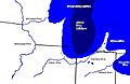
Formation of the Valparaiso Moraine and the Kankakee Valley.
