
List of extreme points of New Zealand facts for kids
New Zealand is a country with many interesting places! This article will tell you about its extreme points – these are the places that are the farthest north, south, east, or west. We'll also look at the highest and lowest spots.
You might know that State Highway 1 goes all the way from Cape Reinga in the north to Bluff in the south. People often think Cape Reinga is the very top of the North Island, but North Cape is actually a tiny bit further north. Cape Reinga is more like the most north-western point. The same goes for Bluff; while it's very far south on the South Island, Slope Point is actually the southernmost tip.
Contents
Extreme Points of New Zealand
New Zealand as a Whole
Here are the most extreme points for all of New Zealand, including its many islands:
- Northernmost point – Nugent Island, part of the Kermadec Islands. This tiny island is way up north! (29°13′54″S 177°52′09″W / 29.23167°S 177.86917°W)
- Southernmost point – Jacquemart Island, which is just off the coast of Campbell Island. It's super far south! (52°37′10″S 169°07′33″E / 52.61944°S 169.12583°E)
- Westernmost point – Cape Lovitt, found in the Auckland Islands. This is the farthest west you can go in New Zealand. (50°47′59.42″S 165°52′12.46″E / 50.7998389°S 165.8701278°E)
- Easternmost point – Forty-Fours / Motuhara, located in the Chatham Islands. These islands are far to the east of the main New Zealand landmass. (43°57′44″S 175°50′01″W / 43.96222°S 175.83361°W)
- Highest point – Aoraki / Mount Cook, which stands tall at 3,724 meters (about 12,218 feet) above sea level. (43°35′42″S 170°8′31″E / 43.59500°S 170.14194°E)
- Lowest point – Near Momona in the Taieri Plains. This spot is about 2 meters (6.5 feet) below sea level! (approximately 45°55′S 170°13′E / 45.917°S 170.217°E)
The farthest point inland in New Zealand is about 8 kilometers (5 miles) northeast of Cromwell. It's about 119 kilometers (74 miles) from both the Tasman Sea and the Pacific Ocean.
The distance from the northernmost point (Nugent Island) to the southernmost point (Jacquemart Island) is about 2,813 kilometers (1,748 miles). If you were to travel around all four extreme points (north, south, east, west), the total distance would be about 6,176 kilometers (3,838 miles)!
Note: These points do not include New Zealand's claims in the Ross Dependency (Antarctica) or its administration of the Tokelau Islands.
North Island Extreme Points
- Northernmost point – Surville Cliffs, part of North Cape.
- Southernmost point – Cape Palliser.
- Westernmost point – Cape Maria van Diemen.
- Easternmost point – East Cape.
- Highest point – Mount Ruapehu, standing at 2,797 meters (9,177 feet) above sea level.
- Lowest point – Lagoon Farm/Parklands in Napier, which is 1 meter (3.3 feet) below sea level. The lowest human-made spot is the Martha Mine pit in Waihi, 15 meters (49 feet) below sea level.
South Island Extreme Points
- Northernmost point – Cape Farewell.
- Southernmost point – Slope Point.
- Westernmost point – West Cape.
- Easternmost point – West Head.
- Highest point – Aoraki / Mount Cook, at 3,724 meters (12,218 feet) above sea level.
- Lowest point – Taieri Plains, 2 meters (6.5 feet) below sea level.
Extreme Settlements
Northernmost Settlements
Te Hāpua is the northernmost settlement on the North Island. However, there used to be a station with people living on Raoul Island, which is even further north. Kaitaia is the northernmost urban area (a place with at least 1,000 people). New Zealand's northernmost city is Whangārei.
On the South Island, the northernmost settlement is Pūponga, near Farewell Spit. Tākaka is the northernmost urban area with over 1,000 people, and Nelson is the northernmost city on the South Island.
Southernmost Settlements
The southernmost settlement in New Zealand is Oban, on Stewart Island. There was once a weather station on Campbell Island even further south, but it hasn't been permanently staffed since 1995. The southernmost town in New Zealand with over 1,000 people is Bluff. New Zealand's southernmost city is Invercargill, which is also its westernmost city. While New Zealand has a permanently staffed base at Scott Base in the Ross Dependency (Antarctica), this area is not considered part of New Zealand itself.
The southernmost settlement on the North Island is Ngawi, near Cape Palliser. Wellington is the southernmost urban area on the North Island with over 1,000 people and the North Island's southernmost city.
Easternmost Settlements
The settlement of Waitangi on Chatham Island is New Zealand's easternmost settlement. On the main islands of New Zealand, the easternmost settlement of note is Tikitiki. The town of Ruatoria is New Zealand's easternmost town. New Zealand's easternmost city and urban area with over 1,000 people is Gisborne.
In the South Island, Ward is the easternmost settlement. Picton is the easternmost town with over 1,000 people, and Nelson is the easternmost city.
Westernmost Settlements
Small settlements at the start of Doubtful Sound and near the Manapouri Hydro are the westernmost settlements in New Zealand. The westernmost settlement of importance is Manapouri, and the westernmost town with over 1,000 people is Te Anau. New Zealand's westernmost city is Invercargill, which is also its southernmost city.
On the North Island, Te Kao is both the westernmost and northernmost settlement of importance. Kaitaia is the westernmost town with over 1,000 people, and New Plymouth is the westernmost city.
Most Remote Settlements
Waitangi on Chatham Island is New Zealand's most remote important settlement. It's over 700 kilometers (435 miles) from mainland New Zealand and any other major settlement.
Twizel (population 1,850) is the country's most remote urban area with over 1,000 people. The closest town by road is Cromwell (population 7,160), which is 141 kilometers (88 miles) away.
Christchurch (population 384,800) is the country's most remote city with over 30,000 people. The closest city in a straight line is Nelson (population 51,900), 256 kilometers (159 miles) away. By road, the closest city is Dunedin (population 106,200), 360 kilometers (224 miles) away.
Closest Point to Australia
The closest point in New Zealand to Australia (not including Australia's Antarctic claims or external territories) is near the Resolution Island lighthouse. This spot is about 1,491 kilometers (926 miles) from a point near the Tasman Island lighthouse in Tasmania, Australia.
The shortest distance from any New Zealand territory to any Australian territory (outside of Antarctic claims) is from Auckland Island to Macquarie Island. This distance is about 617 kilometers (383 miles).
Images for kids
-
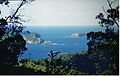
Kermadec Islands (Nugent Island is the northernmost point, but not clearly visible here)
-
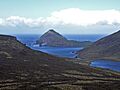
Jacquemart Island in the distance – New Zealand's southernmost point
-
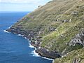
Cape Lovitt – New Zealand's westernmost point
-
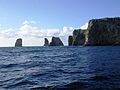
Forty-Fours/Motuhara – New Zealand's easternmost point


See also
- Geography of New Zealand
- Extreme points of Earth
