Geography of New Zealand facts for kids
Quick facts for kids Geography of New Zealand |
|
|---|---|
| Region | Oceania |
| Coordinates | 42°S 174°E / 42°S 174°E |
| Area | Ranked 75th |
| • Total | 268,680 km2 (103,740 sq mi) |
| • Land | 97.9% |
| • Water | 2.1% |
| Coastline | 15,134 km (9,404 mi) |
| Borders | 0 km |
| Highest point | Aoraki / Mount Cook 3,724 m (12,218 ft) |
| Lowest point | Taieri Plain −2 m |
| Longest river | Waikato River 425 km (264 mi) |
| Largest lake | Lake Taupō 3,487 km2 (1,346 sq mi) |
| Climate | Mostly temperate, with some areas being tundra and subantarctic |
| Terrain | Mostly mountainous or steep hills, volcanic peaks in the central North Island, and fiords in the far south west. |
| Natural Resources | Natural gas, iron ore, sand, coal, timber, hydropower, gold, limestone |
| Natural Hazards | Flooding, earthquakes, volcanic activity, tsunamis |
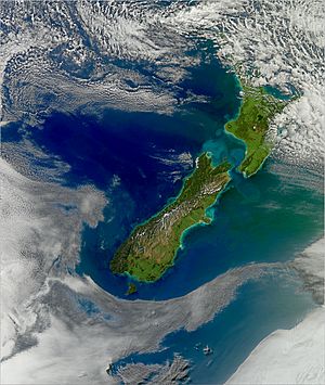
New Zealand (Māori: Aotearoa) is an island country in the southwestern Pacific Ocean. It's located near the center of the water hemisphere, which is the half of Earth with the most water. New Zealand is made up of about 700 islands. Most of these islands are what's left of a much larger landmass called Zealandia, which is now mostly under the sea.
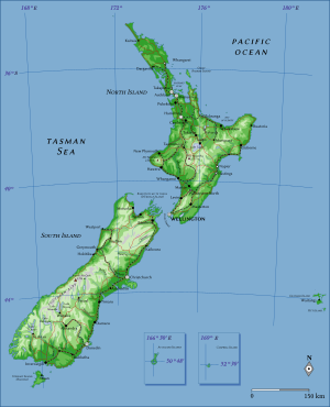
The two main islands are the South Island (called Te Waipounamu in Māori) and the North Island (called Te Ika-a-Māui). They are separated by the Cook Strait. The third largest island is Stewart Island / Rakiura, which is about 30 kilometres (19 miles) south of the South Island. The three biggest islands stretch for 1,600 kilometres (990 miles) from north to south. New Zealand is the sixth-largest island country in the world, covering 268,680 km2 (103,740 sq mi) of land.
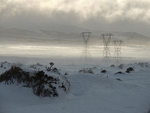
New Zealand's scenery is very diverse. It has fiords (deep, narrow inlets of the sea) in the southwest and sandy beaches in the subtropical Far North. The Southern Alps mountain range dominates the South Island. A volcanic plateau covers much of the central North Island. Temperatures can drop below 0 °C (32 °F) or rise above 30 °C (86 °F). The weather can be wet and cold on the South Island's west coast, but dry and more continental just a short distance away across the mountains. Some areas in the far south have a climate similar to the tundra.
About two-thirds of New Zealand's land is useful for farming or other economic activities. The North Island has the most people, with 4 million residents. Auckland is the largest city. The South Island is bigger in size but has fewer people, with over 1.18 million residents.
New Zealand sits on the edge of two huge tectonic plates: the Pacific Plate and the Australian Plate. This makes it one of the most active places in the world for earthquakes and volcanoes. The country has had several very strong earthquakes in its history.
The main islands of New Zealand are about 2,000 kilometres (1,200 miles) east of Australia, across the Tasman Sea. The closest foreign neighbor is Norfolk Island (part of Australia), about 750 kilometres (470 miles) to the northwest. Other islands nearby to the north include New Caledonia, Tonga, and Fiji. New Zealand is the southernmost country in Oceania. Because it's relatively close to Antarctica, the South Island is a key starting point for scientific trips to the icy continent.
Contents
Exploring New Zealand's Land and Sea
How Big is New Zealand?
New Zealand is located in the South Pacific Ocean at 41°S 174°E / 41°S 174°E. It's a long, narrow country, stretching 1,600 kilometres (990 mi) from north to south. Its widest point is about 400 kilometres (250 mi). With a land area of 268,680 km2 (103,740 sq mi), it's the sixth-largest island country in the world.
New Zealand has about 600 islands in total. These islands give it a long coastline of 15,134 km (9,404 mi). It also has a huge ocean area called an exclusive economic zone, which is about 4,083,744 km2 (1,576,742 sq mi). This zone is more than 15 times larger than its land area!
The South Island is New Zealand's biggest landmass and the 12th-largest island in the world. The Southern Alps mountains run down the length of the island. On the east side, you'll find the Canterbury Plains. The West Coast is known for its rugged shores, heavy rain, lots of native forests (called bush), and glaciers.
The North Island is the second-largest island and the 14th-largest in the world. The Cook Strait separates it from the South Island, with the narrowest point being 23 kilometres (14 mi). The North Island has fewer large mountains than the South Island. However, it does have a chain of narrow mountain ranges that reach up to 1,700 metres (5,600 ft). Many of the remaining forests are found in these mountains and rolling hills. The North Island also has many separate volcanic peaks.
Besides the North and South Islands, the five largest inhabited islands are:
- Stewart Island / Rakiura (30 kilometres (19 mi) south of the South Island).
- Chatham Island (about 800 kilometres (500 mi) east of the South Island).
- Great Barrier Island (in the Hauraki Gulf).
- Rangitoto ki te Tonga / D'Urville Island (in the Marlborough Sounds).
- Waiheke Island (about 22 km (14 mi) from central Auckland).
New Zealand's Farthest Points
People in New Zealand often say "From Cape Reinga to The Bluff" to talk about the entire length of the country. Cape Reinga / Te Rerenga Wairua is the very northern tip of the North Island. Bluff is a port town near the southern tip of the South Island.
However, the actual farthest points of New Zealand are on some of its smaller, faraway islands:
- The northernmost point is Nugent Island in the Kermadec Islands.
- The southernmost point is Jacquemart Island in the Campbell Island group.
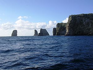
- The easternmost point is in a group of islands called the Forty-Fours, part of the Chatham Islands.
- The westernmost point is Cape Lovitt on Auckland Island.
New Zealand's Opposite Side of the World
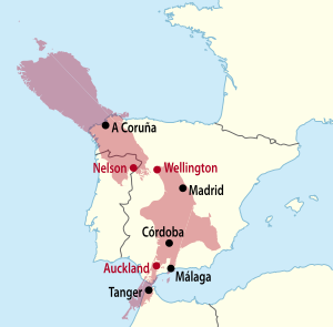
New Zealand is mostly on the opposite side of the world from the Iberian Peninsula in Europe (Spain and Portugal). For example, the northern part of the South Island is opposite Galicia and northern Portugal. Most of the North Island is opposite central and southern Spain, from Valladolid to Gibraltar. Parts of the Northland Peninsula are opposite Morocco.
The Antipodes Islands were named because people thought they were directly opposite Britain. While they are the closest land to Britain's true opposite point, they are actually opposite a spot near Cherbourg in France. In Europe, "Antipodes" is often used to refer to New Zealand and Australia.
New Zealand's Earth Story: Geology and Volcanoes
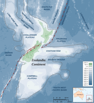
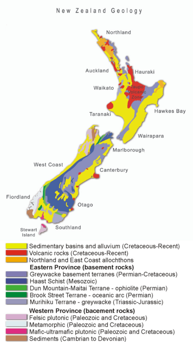
New Zealand is part of Zealandia, a microcontinent that is almost half the size of Australia. Zealandia slowly sank after it broke away from the ancient supercontinent called Gondwana. This submerged continent has high points that sometimes form islands. The main islands of New Zealand, Stewart Island, New Caledonia, and the Chatham Islands are all part of Zealandia.
New Zealand's land has been pushed up by the grinding action of the Indo-Australian Plate and Pacific tectonic plates. These two plates are constantly moving and pushing against each other. This is why New Zealand has so many earthquakes.
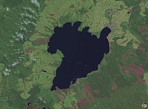
East of the North Island, the Pacific Plate is forced underneath the Indo-Australian Plate. This process, called subduction, causes many volcanoes to form in the North Island. There are several large volcanoes that erupt quite often. There are also huge calderas (collapsed volcanic craters), with the most famous one forming Lake Taupō. Lake Taupō has had incredibly powerful eruptions in the past. The Oruanui eruption about 26,500 years ago was so big that it caused the land to collapse and form the lake. The most recent eruption happened around 180 CE. The heat from this volcanic area is used to create electricity in hydrothermal power plants. Some volcanic areas, like the Rotorua geysers, are also popular tourist spots.
In the South Island, the plates move differently. Here, the Indo-Australian Plate is forced under the Pacific Plate. The area where this change happens, at the top of the South Island, has a lot of uplift and many active faults. Big earthquakes happen often here. The capital city, Wellington, is in the middle of this active region.
The rapid uplift in the South Island forms the Southern Alps. These mountains divide the island, creating a narrow, wet strip on the west and wide, dry plains on the east. The rain that falls on these mountains helps generate most of New Zealand's electricity through hydroelectric power. A large part of the plate movement happens along the Alpine Fault, which is almost 800 kilometres (500 mi) long. This fault is expected to rupture (break) every 330 years or so. The last major rupture was in 1717.
The fast uplift and high erosion in the Southern Alps expose valuable rocks, including the gemstone pounamu (greenstone). The South Island also has two major goldfields, in Otago and the West Coast.
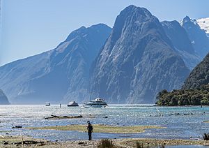
South of New Zealand, the Indo-Australian Plate is also going under the Pacific Plate. This causes new volcanoes to form. The youngest volcanoes in the South Island are the Solander Islands, which are less than 2 million years old. This region is mostly covered by the rugged and wild Fiordland, an area of valleys carved by glaciers and then filled with water. Few people live here.
Mountains, Volcanoes, and Glaciers
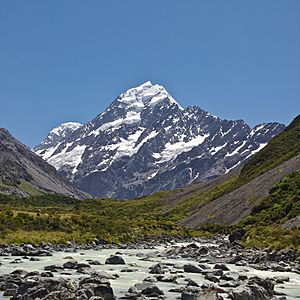
The South Island is much more mountainous than the North Island. It has 18 peaks over 3,000 metres (9,800 feet) high in the Southern Alps, which stretch for 500 kilometres (310 mi). New Zealand's highest mountain is Aoraki / Mount Cook, which is 3,724 metres (12,218 feet) tall. The second highest is Mount Tasman, at 3,497 metres (11,473 ft). The Southern Alps also have huge glaciers like Franz Josef and Fox.
The North Island Volcanic Plateau in the central North Island has many volcanoes, lava plains, and crater lakes. The three highest volcanoes are Mount Ruapehu (2,797 metres (9,177 ft)), Mount Taranaki (2,518 metres (8,261 ft)), and Mount Ngauruhoe (2,287 metres (7,503 ft)). Mount Ruapehu has erupted about every 50 years. The 1886 eruption of Mount Tarawera, near Rotorua, was New Zealand's largest and deadliest eruption in the last 200 years, killing over 100 people. Another long chain of mountains runs through the North Island, from Wellington to East Cape, including the Tararua and Kaimanawa.
The lower slopes of the mountains are covered in native forests. Above the forests, you'll find shrubs and then tussock grasses. Higher up, in the Alpine tundra areas, there are small cushion plants and herbfields, many with white and yellow flowers.
Caves: Underground Wonders
New Zealand's caves form in three main ways:
- Karst caves: These form when water slowly dissolves limestone rock. The main areas for these caves are the Waitomo District and Takaka Hill.
- Lava caves: These are lava tubes that form when the outside of a lava flow hardens, but the liquid lava inside drains away. You can find these where there are recent volcanoes, like on Rangitoto Island near Auckland.
- Sea caves: These are carved out by waves hitting weak spots in coastal rocks.
As caves grow over thousands of years, they can sometimes break through to the surface somewhere else, forming a natural arch, like the Ōpārara Basin Arches.
Rivers and Lakes
About 1.6% of New Zealand's land area (not counting estuaries) is covered by rivers, lakes, and ponds. If you include estuaries and coastal wetlands, it's about 2.2%.
The mountainous areas of the North Island have many rivers. Many of these are fast-flowing and not easy to travel on by boat. The east of the South Island has wide, braided rivers, like the Waimakariri. These rivers, formed by glaciers, spread out into many channels across gravel plains. The total length of all the country's rivers is over 180,000 kilometres (110,000 mi). The Waikato River in the North Island is the longest, at 425 km (264 mi). New Zealand's rivers also have hundreds of waterfalls, with the Huka Falls (where Lake Taupō drains) being very popular.
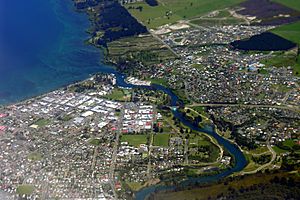
Lake Taupō, in the center of the North Island, is the largest lake by surface area. It sits in a caldera created by the Oruanui eruption, which was the biggest eruption in the world in the last 70,000 years. New Zealand has 3,820 lakes larger than one hectare. Many lakes are used as reservoirs for hydroelectric power plants.
Coastal Wetlands
Wetlands are areas where water covers the soil, or is present near the surface of the soil, for all or parts of the year. They are home to the largest number of different animals and plants. New Zealand has six Ramsar sites, which are wetlands recognized as important worldwide. These cover almost 551 square kilometres (213 sq mi), including the Whangamarino Wetland.
New Zealand's Climate
New Zealand's climate is influenced by its temperate latitude, strong westerly winds, the surrounding ocean, and its mountains, especially the Southern Alps. The climate is mostly temperate, meaning it has mild temperatures. Average temperatures range from 8 °C (46 °F) in the South Island to 16 °C (61 °F) in the North Island. January and February are the warmest months, and July is the coldest. New Zealand doesn't have huge temperature swings, except in central Otago. However, the weather can change very quickly. The Northland region in the far north experiences nearly subtropical conditions.
Most settled, lowland areas get between 600 and 1,600 mm (24 and 63 in) of rainfall each year. The west coast of the South Island gets the most rain, while the east coast and inland basins, like the Canterbury Plains, get the least (about 350 mm (14 in) per year). Christchurch is the driest major city, getting about 640 mm (25 in) of rain annually. Hamilton is the wettest, with over 1,325 mm (52.2 in) per year. The wettest area by far is the rugged Fiordland region in the southwest of the South Island, which gets between 5,000 and 8,000 mm (200 and 310 in) of rain annually, and up to 15,000 mm in some isolated valleys. This is among the highest rainfall in the world!
The UV index (which measures the strength of the sun's ultraviolet rays) can be very high in the north of the North Island during summer. This is partly because New Zealand has very little air pollution and many hours of sunshine. Most areas get over 2000 hours of sunshine per year. The sunniest areas are Nelson/Marlborough and the Bay of Plenty, with 2,400 hours per year.
The table below shows the average daily maximum and minimum temperatures for New Zealand's six largest cities. North Island cities are usually warmest in February, while South Island cities are warmest in January.
| Location | Jan/Feb (°C) | Jan/Feb (°F) | July (°C) | July (°F) |
|---|---|---|---|---|
| Auckland | 23/16 | 74/60 | 14/7 | 58/45 |
| Wellington | 20/13 | 68/56 | 11/6 | 52/42 |
| Christchurch | 22/12 | 72/53 | 10/0 | 51/33 |
| Hamilton | 24/13 | 75/56 | 14/4 | 57/39 |
| Tauranga | 24/15 | 75/59 | 14/6 | 58/42 |
| Dunedin | 19/11 | 66/53 | 10/3 | 50/37 |
Climate change in New Zealand will bring many changes. By the end of this century, New Zealand is expected to have more rainfall, more frequent extreme weather events, and higher temperatures. In 2021, the Ministry for the Environment estimated that New Zealand's total greenhouse gas emissions were 0.17% of the world's total. However, when looking at emissions per person, New Zealand is one of the highest emitters among certain developed countries.
People and Places: Human Geography
Where Do People Live in New Zealand?
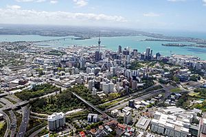
Over the last century, more and more people have moved to the North Island. Today, less than a quarter of New Zealand's population lives in the South Island. More than three-quarters of the population lives in the North Island. Half of all New Zealanders live north of Lake Rotorua, and one-third live in the Auckland Region. Auckland is also the fastest-growing region.
Most New Zealanders live in cities. About 84.2% of the population lives in urban areas. About 64.6% live in the 20 main cities (with populations of 30,000 or more). And 43.3% live in the four largest cities: Auckland, Christchurch, Wellington, and Hamilton. New Zealand's population density is very low, with about 19 people per square kilometer.
New Zealand's people have been shaped by immigration. The country's culture is a mix of different groups adapting to a new land. The most common language spoken is English (89.8%). However, the Māori language (3.5%) is more common in areas with many Māori people, like Gisborne and Northland. There are also many other languages spoken, like Samoan, Hindi, and various Chinese dialects. These are mostly found in the larger cities, especially Auckland, where many new immigrants settle.
Farming in New Zealand
Only a small part of New Zealand's land is suitable for growing crops (1.76%). About 7,210 square kilometres (2,780 sq mi) of land is irrigated (watered artificially). New Zealand is the world's largest exporter of sheep. Its farming industry mainly focuses on raising animals like dairy cows, beef cattle, and lambs. Dairy products are the top export. Besides animal farming, people also harvest mussels, oysters, and salmon. Farmers also grow fruits like kiwifruit, peaches, and nectarines.
New Zealand's distance from other countries and its varied rainfall, elevation, and soil quality have shaped where and how farming is done. As of 2007, almost 55% of New Zealand's land was used for farming. Three-fourths of this was pasture land for animals. The amount of farmland has decreased since 2002.
New Zealand's isolated location means it has fewer pests than some other places. However, it also means its farms are more easily affected by new diseases and pests that are introduced. A big problem for farmers is the rapidly growing wild rabbit population. Rabbits have been a problem since they were brought to the country in the 1930s. They eat grass and crops, and damage the soil. Farmers worry about their livelihoods and how rabbits will affect food supply.
In 1997, some farmers illegally released a rabbit-killing virus called the rabbit haemorrhagic disease virus (RHDV). It worked well at first, but after 20 years, the rabbits became immune. In March 2018, a new strain of the virus, called K5, was released. This virus aims to kill 40% of the rabbit population and works much faster. Some animal rights groups are concerned about the virus because of how it kills the rabbits. However, farmers are generally very thankful for the virus.
Almost half of New Zealand's climate change emissions come from farming. These are mainly greenhouse gases like methane and nitrous oxide, which come from grazing animals. While more carbon dioxide in the air helps plants grow faster, the long-term effects of climate change threaten farmers with more frequent and severe floods and droughts. Kiwifruit growers have faced problems because of climate change. Warm winters in the 2010s meant kiwifruit plants didn't get enough cold weather to flower properly, leading to smaller harvests. Droughts have also reduced apple production. However, the dairy industry has adjusted well to climate change effects so far.
Natural Hazards in New Zealand
Flooding is the most common natural hazard. New Zealand often gets heavy rain from weather systems. Towns are usually near hills, which get much more rain than lowlands because of the orographic effect (rain caused by air rising over mountains). Mountain streams can rise quickly and overflow, covering farms with water and mud. Close monitoring, weather forecasts, stopbanks (walls to hold back water), dams, and replanting trees in hill country have helped reduce the worst effects.
New Zealand experiences about 14,000 earthquakes a year. Some are very strong, over magnitude 7. Since 2010, several large and shallow earthquakes have happened near Christchurch. These caused 185 deaths, widespread damage to buildings, and significant liquefaction (where soil behaves like a liquid during shaking). Volcanic activity is most common on the central North Island Volcanic Plateau. Tsunamis affecting New Zealand are linked to the Pacific Ring of Fire.
Droughts are not common and happen mainly in Otago and the Canterbury Plains. They occur less often in the North Island between January and April. Forest fires were rare in New Zealand before humans arrived. During summer, lighting fires in public conservation areas is banned.
Nature and Wildlife: Environment and Ecology
New Zealand was geographically isolated for 80 million years. This isolation has greatly influenced how its unique animals, fungi, and plants evolved. The native forests, called bush, are dominated by evergreen trees like the giant kauri and southern beech. The country also has a diverse range of birds. Several are flightless, such as the kiwi (a national symbol), the kākāpō, the takahē, and the weka. There are also several species of penguins. About 30 bird species are currently listed as endangered or critically endangered.
Many bird species, including the giant moa, became extinct after Polynesians arrived, bringing dogs and rats. Europeans later introduced more dogs and rats, as well as cats, pigs, ferrets, and weasels. Native plants and animals continue to be severely affected by invasive species. New Zealand conservationists have developed new ways to help threatened wildlife. These include creating island sanctuaries, controlling pests, moving wildlife to new areas, fostering young animals, and restoring islands and other special areas.
Massive deforestation happened after humans arrived. About half of the forest cover was lost to fire after Polynesian settlement. Much of the remaining forest was cut down after European settlement to make way for farms. Today, forests cover only 23% of the land.
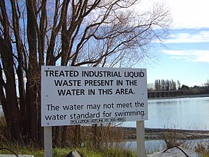
Pollution, especially water pollution, is one of New Zealand's biggest environmental problems. The quality of fresh water is under pressure from farming, hydropower, city growth, pest invasions, and climate change. However, much of the country's household and industrial waste is now increasingly filtered and sometimes recycled.
Protected Areas: Saving Nature
Some areas of land, sea, rivers, or lakes are protected by law. This means their special plants, animals, landforms, and other unique features are kept safe from harm. New Zealand has three World Heritage Sites, 13 national parks, 34 marine reserves, and thousands of other scenic, historic, and recreation reserves. The Department of Conservation manages about 8.5 million hectares of public land, which is about 30% of New Zealand's total land area.
Environmental Agreements
New Zealand is part of several international agreements to protect the environment. Some of the major ones are:
|
|
New Zealand in Pop Culture
New Zealand's beautiful and varied landscapes have been featured in many TV shows, like Hercules: The Legendary Journeys and Xena: Warrior Princess. More and more movies are also filmed in New Zealand because of its amazing scenery, including The Lord of the Rings trilogy.
New Zealand is sometimes accidentally left off world maps. This is because it's physically isolated, relatively small compared to Australia, and often placed at the very bottom-right of many map styles, like the Mercator. This has become a popular joke, and there's even a dedicated online community about it!
See also
 In Spanish: Geografía de Nueva Zelanda para niños
 | Tommie Smith |
 | Simone Manuel |
 | Shani Davis |
 | Simone Biles |
 | Alice Coachman |


