Madison County, Alabama facts for kids
Quick facts for kids
Madison County
|
||
|---|---|---|

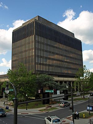
Madison County Courthouse in Huntsville
|
||
|
||

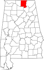
Location within the U.S. state of Alabama
|
||
 Alabama's location within the U.S. |
||
| Country | ||
| State | ||
| Founded | December 13, 1808 | |
| Named for | James Madison | |
| Seat | Huntsville | |
| Largest city | Huntsville | |
| Area | ||
| • Total | 813 sq mi (2,110 km2) | |
| • Land | 802 sq mi (2,080 km2) | |
| • Water | 11 sq mi (30 km2) 1.4% | |
| Population
(2020)
|
||
| • Total | 388,153 | |
| • Estimate
(2023)
|
412,600 |
|
| • Density | 477.43/sq mi (184.34/km2) | |
| Time zone | UTC−6 (Central) | |
| • Summer (DST) | UTC−5 (CDT) | |
| Congressional district | 5th | |
|
||
Madison County is a special area called a county in the northern part of Alabama, a state in the United States. In 2020, about 388,153 people lived here. By 2023, it became the second-most populated county in Alabama!
The main city and government center of the county is Huntsville. Since the middle of the 1900s, Madison County has become a major hub for defense and space research. This means a lot of work happens here on rockets and other advanced technology. The county is named after James Madison, who was the fourth President of the United States. He was also the first President to visit Alabama. Madison County is part of the larger Huntsville Metropolitan Area.
Contents
History of Madison County
Madison County was created on December 13, 1808. This was done by the governor of the Mississippi Territory. It's known as the "birthplace" of the state of Alabama. Alabama officially joined the United States on December 14, 1819. Huntsville was chosen as the very first capital city of the new state.
For many years, the county's economy was mostly about farming. People grew a lot of cotton on large farms called plantations. Before the Civil War, these farms used the forced labor of enslaved African Americans. Madison County was one of the biggest cotton-producing areas in Alabama.
Madison County had the largest population in Alabama from 1810 to 1840. In 1810, almost half of the people in what would become Alabama lived here. This count did not include Native American tribes. But by 1850, Madison County's population growth slowed down. It became the 7th largest county. This was likely because it relied mostly on cotton, with few other industries.
Cotton remained important even after the Civil War. Many African Americans still worked on farms, but they were now sharecroppers or tenant farmers. Later, in the late 1800s, factories that made cloth from cotton were built. These factories only hired white workers because of unfair rules called Jim Crow laws. In the early 1900s, farming was still important, but the cloth factories grew bigger.
During World War II, the Army built Redstone Arsenal here. It was a place to make chemical weapons. This brought new industries to the county. After the war, Redstone Arsenal became a center for new weapons and rocket development. In 1950, a group of German rocket scientists came to Redstone Arsenal. They were led by Wernher von Braun. They came to research and develop new types of rockets.
By the 1960s, this research expanded to rockets for space travel. The Redstone rocket was changed to send the first two Americans into space. The U.S. started to invest a lot in the Space Race. This was to compete with the Soviet Union during the Cold War. It also helped increase scientific discoveries. All this work in defense and space has created many jobs. Most of these jobs are for private companies. The number of people living in Madison County has grown a lot. It went from 72,903 people in 1950 to an estimated 403,565 in 2022.
Geography of Madison County
Madison County covers about 813 square miles. Most of this area, about 802 square miles, is land. The rest, about 11 square miles, is water.
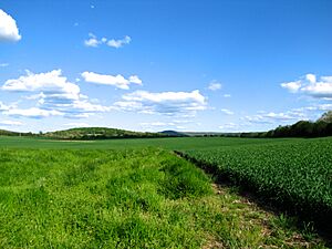
The southern and eastern parts of the county have many hills and mountains. These are parts of the Cumberland Plateau. Examples include Keel Mountain, Monte Sano Mountain, and Green Mountain. The northern and western parts of the county are flatter.
Rivers in Madison County
Neighboring Counties

- Lincoln County, Tennessee (north)
- Franklin County, Tennessee (northeast)
- Jackson County (east)
- Marshall County (southeast)
- Morgan County (southwest)
- Limestone County (west)
Protected Natural Areas
- Wheeler National Wildlife Refuge (part of it is in Madison County)
People of Madison County
| Historical population | |||
|---|---|---|---|
| Census | Pop. | %± | |
| 1810 | 4,699 | — | |
| 1820 | 17,481 | 272.0% | |
| 1830 | 27,990 | 60.1% | |
| 1840 | 25,706 | −8.2% | |
| 1850 | 26,427 | 2.8% | |
| 1860 | 26,451 | 0.1% | |
| 1870 | 31,267 | 18.2% | |
| 1880 | 37,625 | 20.3% | |
| 1890 | 38,119 | 1.3% | |
| 1900 | 43,702 | 14.6% | |
| 1910 | 47,041 | 7.6% | |
| 1920 | 51,268 | 9.0% | |
| 1930 | 64,623 | 26.0% | |
| 1940 | 66,317 | 2.6% | |
| 1950 | 72,903 | 9.9% | |
| 1960 | 117,348 | 61.0% | |
| 1970 | 186,540 | 59.0% | |
| 1980 | 196,966 | 5.6% | |
| 1990 | 238,912 | 21.3% | |
| 2000 | 276,700 | 15.8% | |
| 2010 | 334,811 | 21.0% | |
| 2020 | 388,153 | 15.9% | |
| 2023 (est.) | 412,600 | 23.2% | |
| U.S. Decennial Census 1790–1960 1900–1990 1990–2000 2010–2020 |
|||
Population in 2020
In 2020, there were 388,153 people living in Madison County. There were 157,770 households, which are groups of people living together. About 101,684 of these were families. The county had about 484 people per square mile. There were also 169,820 housing units, like houses or apartments.
Population in 2010
In 2010, Madison County had 334,811 people. There were 109,955 households. About 33% of these households had children under 18. More than half (53.4%) were married couples. About 11.8% had a female head of the house with no husband. About 27.2% of households were single people living alone.
The population was spread out by age:
- 25.6% were under 18
- 9.4% were 18 to 24
- 31.5% were 25 to 44
- 22.7% were 45 to 64
- 10.8% were 65 or older
The average age was 36 years. For every 100 females, there were about 95 males.
The average income for a household in the county was $44,704. For a family, it was $54,360. About 10.5% of the people in the county lived below the poverty line. This included 14.1% of those under 18 and 9.6% of those 65 or older.
Communities in Madison County
Madison County has several cities, towns, and other communities.
Cities in Madison County
- Huntsville (This is the county seat, where the main government offices are. Parts of it are also in other counties.)
- Madison (Also partly in another county.)
- New Hope
- Owens Cross Roads
Towns in Madison County
Census-Designated Places (CDPs)
These are areas that are like towns but are not officially incorporated.
- Harvest
- Hazel Green
- Meridianville
- Moores Mill
- New Market
- Redstone Arsenal
Unincorporated Communities
These are smaller communities that are not officially part of a city or town.
Education in Madison County
The Madison County School System manages public schools. These schools are in the county's rural areas and in many of its communities. This includes Gurley, Harvest, Hazel Green, Meridianville, Moores Mill, New Hope, Owens Cross Roads, New Market, Redstone Arsenal, Toney, and Monrovia. The system has 14 elementary schools, 4 middle schools, 5 high schools, a ninth-grade school, and a career/technical center.
High schools in the Madison County School System are:
- Buckhorn High School (in New Market)
- Hazel Green High School
- Madison County High School (in Gurley)
- New Hope High School
- Sparkman High School (in Harvest)
There are also many private schools in Madison County. Some of these are Randolph School, Madison Academy, Westminster Christian Academy, and Faith Christian Academy.
The cities of Madison and Huntsville have their own separate school systems. These are the Madison City School District and the Huntsville City School District. The Madison City School District also includes the town of Triana.
Transportation in Madison County
Getting around Madison County is easy with various ways to travel.
Major Highways
 Interstate 565
 U.S. Highway 72 (also known as University Drive in Huntsville)
 U.S. Highway 231 (also known as Memorial Parkway in Huntsville)
 U.S. Highway 431 (also known as Governors Drive and Memorial Parkway in Huntsville)
 State Route 53 (also known as Jordan Lane in Huntsville)
 State Route 255 (also known as Research Park Boulevard)
Public Transit
- Orbit (a bus system)
Railroads
- Norfolk Southern Railway
- Huntsville and Madison County Railroad Authority
Air Travel
The Port of Huntsville offers both passenger flights and cargo shipping.
- Huntsville International Airport lets people fly to most parts of the United States.
- The International Intermodal Center handles air cargo.
There are also three smaller public airports in the county:
- Hazel Green Airport
- Madison County Executive Airport
- Moontown Airport
Bicycle Routes
Huntsville has several paths for bicycles. Madison County also plans to build a 70-mile path for biking and walking.
Places to Visit in Madison County
Madison County has many interesting places to see and things to do.
- Monte Sano State Park is a beautiful park with mountains and trails.
- The U.S. Space & Rocket Center is a museum where you can learn all about space exploration and rockets.
- Part of the Flint River flows through the county, offering scenic views.
- Hampton Cove Golf Course is a large golf course, part of the Robert Trent Jones Golf Trail.
- There is a historical marker for Lincoln School and Village. These areas became part of Huntsville in 1956.
See also
 In Spanish: Condado de Madison (Alabama) para niños
 | Frances Mary Albrier |
 | Whitney Young |
 | Muhammad Ali |


