
Khyber Pakhtunkhwa facts for kids
Quick facts for kids
Khyber Pakhtunkhwa
|
|||
|---|---|---|---|
  .jpg)   Top left to right: Bab-e-Khyber, Mohabbat Khan Mosque, Kalam Valley, Bahrain, Swat Valley, and Lake Saiful Muluk
|
|||
|
|||
| Nickname(s):
Frontier, Frontier Province, Sarhad
|
|||
.svg) |
|||
| Country | |||
| Established | 14 August 1947 re-established 1 July 1970 |
||
| Capital | Peshawar | ||
| Largest city | Peshawar | ||
| Government | |||
| • Type | Province | ||
| • Body | Provincial Assembly | ||
| Area | |||
| • Total | 101,741 km2 (39,282 sq mi) | ||
| Population
(2017)
|
|||
| • Total | 35,525,047 | ||
| • Density | 349.1714/km2 (904.350/sq mi) | ||
| Assembly seats | 124 | ||
| Districts | 35 | ||
| Union Councils | 986 | ||

Khyber Pakhtunkhwa (often called KPK) is one of the four main areas, or provinces, of Pakistan. It is in the northwestern part of the country. This province shares a border with Afghanistan.
Before 2010, it was known as the North-West Frontier Province. Its name was changed to Khyber Pakhtunkhwa in 2010. This change happened through an important update to Pakistan's Constitution.
Khyber Pakhtunkhwa is the third-largest province in Pakistan. This is true for both its population and its economy. However, it is the smallest of the four provinces in terms of land size. This area was once home to the ancient kingdom of Gandhara. The ruins of its old capital, Pushkalavati, are near the city of Charsadda.
The region has a long history. It was once a strong center for Buddhism. Because it is close to the Khyber Pass, many different empires invaded it over time. After 2001, the province faced some difficult times. Many people had to move from their homes for safety.
In 2018, a big change happened. The FATA region officially became part of Khyber Pakhtunkhwa. This was a historic merger.
Contents
Early History of Khyber Pakhtunkhwa

During the time of the Indus Valley Civilization, the Khyber Pass was very important. This pass, located in the Hindu Kush mountains, was a trade route. Merchants used it to travel to other regions. Around 1500 BCE, groups of Indo-Aryan peoples also used this pass. They traveled through it to reach areas like modern-day Iran, Pakistan, Afghanistan, and North India.
The city of Peshawar is the capital today. In ancient times, it was called Purushapura. This region was once a Hindu area. It was also known as a major center for learning.
Music and Culture
Music is a big part of the culture in Khyber Pakhtunkhwa. Hindko and Pashto folk music are very popular. These music styles have a history going back hundreds of years. The main instruments used are the rubab, mangey, and harmonium.
In Chitral and northern Swat, Khowar folk music is enjoyed. The tunes of Khowar music are different from Pashto music. The main instrument for Khowar music is the Chitrali sitar. A type of band music is also popular in Chitral. It uses clarinets (called surnai) and drums. This music is played at polo matches and dances.
Geography and Landscape

Khyber Pakhtunkhwa is mostly on the Iranian plateau. It is where the Hindu Kush mountains meet the hills near the Indus River. This area has had earthquakes in the past. The famous Khyber Pass connects the province to Afghanistan. The Kohalla Bridge in Circle Bakote Abbottabad is an important crossing. It goes over the Jhelum River in the east.
The Sheikh Badin Hills are made of sandstone. They stretch from the Sulaiman Mountains to the Indus River. These hills separate Dera Ismail Khan District from the plains of Lakki Marwat District. The highest point is the limestone Sheikh Badin Mountain. This mountain is protected as part of the Sheikh Badin National Park.

Near the Indus River, there are limestone hills called the Kafir Kot hills. Here, you can find the ancient Hindu complex of Kafir Kot.
The province has two main geographical zones. The northern zone goes from the Hindu Kush mountains to the Peshawar basin. It is cold and snowy in winter. It also gets a lot of rain and has pleasant summers. The southern zone stretches from Peshawar to the Derajat basin. This area is dry. It has hot summers and cold winters.
The province has many beautiful places. Its snow-capped peaks and green valleys are great for tourism. Khyber Pakhtunkhwa has about 18 National Parks.
National Parks of Khyber Pakhtunkhwa


Economy of Khyber Pakhtunkhwa

Khyber Pakhtunkhwa has the third largest provincial economy in Pakistan. One important part of its economy is forestry. The province also produces 10% of Pakistan's mining output. Since 1972, its economy has continued to grow.
Agriculture is still very important. The main crops grown here include wheat, maize, tobacco, rice, and sugar beets. Many different fruits are also grown. Workshops across the province make small arms and weapons. Khyber Pakhtunkhwa produces at least 78% of the marble in Pakistan.
New factories and technology businesses in Peshawar have created more jobs. Trade is also a big part of the economy. The markets, or bazaars, in the province are well-known throughout Pakistan. New industrial zones have helped reduce the number of people without jobs.
Images for kids
-
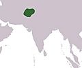
Approximate boundaries of the Gandharan Empire; Alexander's Army also passed through this area centered on the modern-day Khyber Pakhtunkhwa province of Pakistan
-
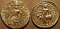
Gold coin of Kushan king Kanishka II, featuring lord Shiva (200–220 AD)
-
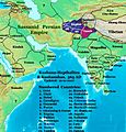
Asia in 565 CE, showing the Shahi kingdoms, centered on modern Khyber Pakhtunkhwa.
-
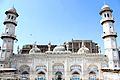
Bestowed by Mohabbat Khan bin Ali Mardan Khan in 1630, the white-marble façade of the Mohabbat Khan Mosque is one of Peshawar's most iconic sights.
-
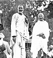
Bacha Khan with Mahatma Gandhi
-
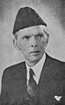
Muhammad Ali Jinnah, the founder of Pakistan
-
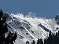
Ghabral, Swat Valley
-
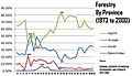
Khyber Pakhtunkhwa's dominance: forestry
-
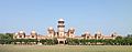
University of Peshawar
-
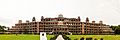
Islamia College University
-
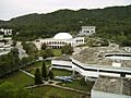
Ghulam Ishaq Khan Institute of Engineering Sciences and Technology


.jpg)
See also
 In Spanish: Jaiber Pastunjuá para niños
