
Pembina County, North Dakota facts for kids
Quick facts for kids
Pembina County
|
|
|---|---|

Pembina County Courthouse before 1920
|
|

Location within the U.S. state of North Dakota
|
|
 North Dakota's location within the U.S. |
|
| Country | |
| State | |
| Founded | January 9, 1867 (created) August 12, 1867 (organized) |
| Named for | a Chippewa term |
| Seat | Cavalier |
| Largest city | Cavalier |
| Area | |
| • Total | 1,121 sq mi (2,900 km2) |
| • Land | 1,119 sq mi (2,900 km2) |
| • Water | 2.7 sq mi (7 km2) 0.2% |
| Population
(2020)
|
|
| • Total | 6,844 |
| • Estimate
(2022)
|
6,763 |
| • Density | 6.105/sq mi (2.3573/km2) |
| Time zone | UTC−6 (Central) |
| • Summer (DST) | UTC−5 (CDT) |
| Congressional district | At-large |
Pembina County is a county located in the state of North Dakota in the United States. In 2020, about 6,844 people lived there. The main town and county seat is Cavalier.
Contents
History of Pembina County

For thousands of years, different Native American groups lived in the area around the Pembina and Red rivers. When Europeans first arrived in the 1500s, the main tribes were the Assiniboine and the Lakota (also called Sioux).
The Ojibwe people, also known as Chippewa, slowly moved west from the Great Lakes. They traded a lot with French trappers and settlers. Many French trappers married Native American women. Their children and grandchildren, known as the Métis, continued to hunt and trap. The Ojibwe and Métis often supported the French during wars against Great Britain.
After Great Britain won the Seven Years' War, the Chippewa had to deal with a new trading system. By the late 1700s, the Chippewa had guns from trading and horses from the Mandan and Hidatsa tribes. They moved onto the Great Plains and pushed the Lakota further west. During the War of 1812, the Ojibwe teamed up with the British against the United States. They hoped to stop European-American settlers from moving onto their land.
After the border with Canada was set, the Chippewa in the Dakota Territory had to work with the United States. For many years, the Chippewa and Lakota fought along the Red River. The Chippewa eventually pushed the Lakota into what is now western North and South Dakota.
In 1849, a Catholic Jesuit missionary named Father George Belcourt described the Pembina area. He said it included all the land watered by rivers flowing into the Red River, south of the 49th parallel (the border with Canada). This huge area stretched about 400 miles north to south and over 500 miles east to west. It had prairies, rivers, and lakes, and was home to many buffalo. The Chippewa and Métis relied on these buffalo for food.
The Métis used special two-wheeled carts pulled by oxen to carry furs to markets. These markets were along the Red River Trails, connecting what is now Winnipeg, Canada, to Mendota or St. Paul, Minnesota. They also used these carts for long buffalo hunts.
Over time, the Ojibwe agreed to give up much of their land to the U.S. government through treaties. The government then sold this land to settlers. The Ojibwe moved to smaller Indian reservations within their original territory.
The first Pembina County was in the Minnesota Territory. When Minnesota became a state in 1858, its western border was the Red River. The land to the west became unorganized. A new Pembina County was created in the Dakota Territory on January 9, 1867. Its government officially started on August 12, 1867. The county was named after a Chippewa word meaning "stab" or "stabbing."
Pembina, the oldest European-American settlement in North Dakota, was the first county seat. In 1911, the county seat was moved to Cavalier. The county's borders changed several times but have been the same since 1887. Many new counties, like Cass County and Grand Forks County, were formed from parts of Pembina County.
Icelandic State Park is in Pembina County. The first settlers from Iceland in North Dakota arrived in Pembina County in the late 1870s. They came from the "New Iceland" settlements near Lake Winnipeg.

Many of these Icelandic immigrants settled in areas called "Icelandic Townships," like Akra, Beaulieu, Gardar, and Thingwalla. In the early 1900s, very few non-Icelandic families lived there. You can still see this history in the names of some towns and townships. For example, Akra was named after a town in Iceland, and Gardar was named after the first Scandinavian to visit Iceland.
Icelandic State Park was created to help remember and preserve the history of these early pioneers.
Geography of Pembina County
Pembina County is in the very northeastern corner of North Dakota. Its northern border touches Canada, and its eastern border is next to Minnesota. The Red River of the North flows north along the county's eastern edge.
The Pembina River flows east through the northern part of the county and joins the Red River. The Tongue River also flows northeast and joins the Pembina River. The land in the county has rolling hills and river valleys. Most of the land is used for farming.
The land slopes down towards the east and north. The highest point is about 1,302 feet (397 meters) above sea level on the western border. The county covers a total area of 1,121 square miles (2,903 square kilometers). Most of this is land (1,119 square miles or 2,898 square kilometers), with a small amount of water (2.7 square miles or 7.0 square kilometers). The lowest point in North Dakota is in Pembina County, where the Red River flows out of the state into Manitoba, Canada.
Main Roads
 Interstate 29
 U.S. Highway 81
 North Dakota Highway 5
 North Dakota Highway 18
 North Dakota Highway 32
 North Dakota Highway 44
 North Dakota Highway 66
 North Dakota Highway 89
Neighboring Areas
- Rural Municipality of Stanley, Manitoba, Canada - northwest
- Municipality of Rhineland, Manitoba, Canada - north
- Rural Municipality of Montcalm, Manitoba, Canada - northeast
- Kittson County, Minnesota - east
- Marshall County, Minnesota - southeast
- Walsh County - south
- Cavalier County - west
Parks and Protected Areas
- Frost Fire Ski and Snow Board Area
- Houghton National Wildlife Management Area
- Icelandic State Park
- Juhl National Wildlife Management Area
- McDonald National Wildlife Management Area
- Pembina Gorge State Recreation Area
- Pembina Prairie National Wildlife Management Area
- Tetrault State Forest (part)
People of Pembina County
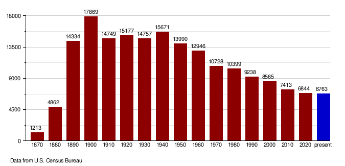
| Historical population | |||
|---|---|---|---|
| Census | Pop. | %± | |
| 1870 | 1,213 | — | |
| 1880 | 4,862 | 300.8% | |
| 1890 | 14,334 | 194.8% | |
| 1900 | 17,869 | 24.7% | |
| 1910 | 14,749 | −17.5% | |
| 1920 | 15,177 | 2.9% | |
| 1930 | 14,757 | −2.8% | |
| 1940 | 15,671 | 6.2% | |
| 1950 | 13,990 | −10.7% | |
| 1960 | 12,946 | −7.5% | |
| 1970 | 10,728 | −17.1% | |
| 1980 | 10,399 | −3.1% | |
| 1990 | 9,238 | −11.2% | |
| 2000 | 8,585 | −7.1% | |
| 2010 | 7,413 | −13.7% | |
| 2020 | 6,844 | −7.7% | |
| 2022 (est.) | 6,763 | −8.8% | |
| U.S. Decennial Census 1790-1960 1900-1990 1990-2000 2010-2020 |
|||
Population Changes Over Time
This chart shows how the population of Pembina County has changed over the years.
More About the People
In 2010, there were 7,413 people living in Pembina County. About 95.5% of the people were white, and 1.9% were Native American. People from German backgrounds made up the largest group (33.8%), followed by Norwegian (21.3%).
About 24.5% of households had children under 18. The average household had 2.23 people. The average age of people in the county was 46.7 years old.
Towns and Communities
Cities
Small Communities (Unincorporated)
Townships
- Advance
- Akra
- Bathgate
- Beaulieu
- Carlisle
- Cavalier
- Crystal
- Drayton
- Elora
- Felson
- Gardar
- Hamilton
- Joliette
- La Moure
- Lincoln
- Lodema
- Midland
- Neche
- Park
- Pembina
- St. Joseph
- St. Thomas
- Thingvalla
- Walhalla
Native American Reservations
Old Towns (Ghost Towns)
- Bowesmont
- Concrete
See also
 In Spanish: Condado de Pembina (Dakota del Norte) para niños
